ABSTRACT
Understanding the spatial distribution and habitat utilization by animals play a significant role in wildlife conservation and habitat management for the benefits of both animals and communities living close to protected areas. This study was conducted to identify the distribution and habitat use of Crocodilus niloticus in Tekeze River Dam through qualitative and quantitative surveys based on diurnal survey, semi-structured questionnaire and geographic information system (GIS) spatial analysis methods. The Tekeze River Dam representing the study area was divided into seven stratified river stratum. All spatial data were recorded and analyzed using ArcGIS 10 software. The distribution revealed that C. niloticus were registered along the main river stretch and its tributaries. Majority of C. niloticus prefer river banks, shallow water depth and rocky ground to perform their activity patterns. Along the 71.2 km² of the study area delineated for habitat preferences, 9.78 km2 was the highly suitable habitat while 4.63 km2 was the least suitable. The influence on communal resources, fishery activities and irrigation practice at small-scale on river banks and increment of water level due to flooding of the Tekeze River Dam were among the primary causes of disturbances induced by human to C. niloticus distribution and its habitats. The perception of most respondents to the conservation of this specie was not encouraging although their presence in the river was important in keeping the ecological balance of the ecosystem. It is therefore suggested that the success of conservation programs and habitats management should focus on educating the local community to raise awareness and change their attitudes towards promoting conservation development initiatives of C. niloticus in the area.
Key words: Crocodilus niloticus, distribution, habitat preferences, Tekeze River Dam, threatened specie.
Understanding the spatial distribution and habitat utilization of animals is very important for wildlife conservation and management for both biodiversity protection and the livelihoods benefits of communities living close to protected areas. The spatial distribution of an organism is mainly influenced by the appropriateness of the environment (Aarts et al., 2008). The ecological requirement, habitat use and preferences of the concerned organisms tend therefore to play key roles in wildlife conservation and management (Aramde et al., 2011; Ekwal et al., 2012). Ethiopia is a large country with diverse agro-ecological zones and rich in biodiversity. However, some Ethiopian wildlife populations tend to be threatened due to habitat disturbances, hunting and environmental pollution. This is also the case with crocodiles. Worldwide, crocodiles are known as threatened species due to overexploitation, hunting or killing of animals, habitat loss, pollution and human disturbances (Ross, 1998; Fergusson, 2010; Ijeomah and Efenakpo, 2011).
Among the other factors driving crocodilian population’s decline includes also, invasive plant species such as alien plant (Chromolaena odorata) that affect breeding of Crocodilus niloticus in case of the Lake St and Lucia as an alien plant in South Africa (Leslie and Spotila, 2001). The loss of any species of crocodiles would therefore lead to threat on biodiversity and a decline of a key species that depend on crocodiles for survival (Fergusson, 2010). Among the well-known crocodile species along the Nile River valley includes the C. niloticus. It is an apex semi-aquatic predator, known as symbolic specie of a great importance to civilization of the area and serves as a model organism for international wildlife conservation. In recent times, a number of surveys on C. niloticus have been conducted throughout Africa and its range as well as in some areas of Ethiopia like Lake Chamo, southern part of Ethiopia on its distribution (Ross, 1998; Whitaker and Whitaker, 2007; Hekkala et al., 2011).
Although there are very little studies about crocodiles in Ethiopia, however crocodiles often play a key role in maintaining and safeguarding biodiversity of wetlands. They are also considered as environmental indicator species, especially for the build-up of contaminants and as apex predators. They contribute also by playing an essential role in the nutrients recycling (Botha, 2011; Ijeomah and Efenakpo, 2011). Meanwhile, crocodiles also represent a good source of income generation through the sale of skin and its meats to tourists as well as through crocodile ranching/farming for enterprises development. The status of these species represents therefore an indicator of the overall health of wetland ecosystems. In the past, Ethiopia was known as the habitat of the largest Nile crocodile populations that occurred in the Rift-Valley Lakes and rivers.
Today, the populations of Nile crocodile have declined to near extinct in the region but there is still lack of information on Ethiopian crocodiles’ population, distribution and habitat preferences. This has led to the limited understanding on the human-wildlife interactions, the implementation of effective conservation strategies, habitat management and sustainable management of crocodiles’ population as valuable source of income generation for local communities in the country. In addition, there is also a lack of research study assessing the population status of crocodiles such as C. niloticus so as to conserve, manage and sustainably utilize that specie in the northern parts of Ethiopia in general, and in Tekeze River Dam, in particular. Therefore, the purpose of this study was to determine the distribution, habitat use and to establish a baseline data of the current status of C. niloticus in Tekeze River Dam, Tigray, Ethiopia.
Study area
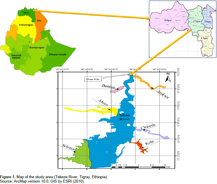
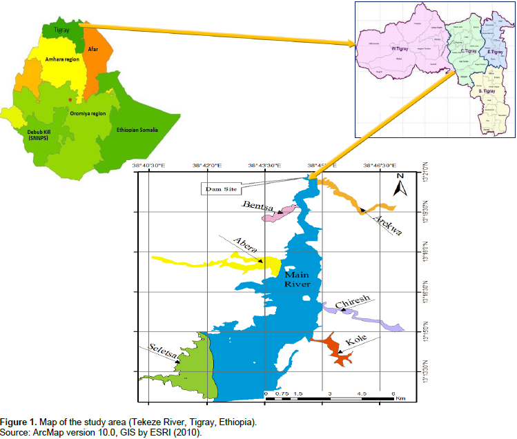
The Tekeze River Dam (hereafter TRD) representing the study area is located in Tigray Regional National State of Ethiopia and at 142 km faraway from Mekelle (capital city of Tigray) in the west side of the study site. It is located at 13° 16' 0” N - 13° 21’ 0” N latitude and 38° 42' 0" E 38° 47’ 0’’ E longitude with an altitudinal range of 727 to 4517 m a.s.l (Figure 1). The catchment area of Tekeze River Dam was 30,390 km2 while the topography accounts for high peaks and plateaus as well as deep canyon gorges. Tekeze River Basin experiences a climate with a maximum temperature ranging between 21 to 43°C and a minimum falling between 3 to 19°C. In the lowlands, mean annual rainfall is 600 mm and 1,300 mm in the Simians Mountains and in the highlands of river basin. This river initially originated from North Wollo Highland covering an area of 82,350 km2 and flowing to the West Nile directions which has annual runoff of approximately 7.6 BM3.
Methods of data collection and surveyed
To collect all relevant data necessary for determining the spatial distribution and habitat preferences of C. niloticus in TRD, qualitative and quantitative surveys were carried out from November 2012 to May 2013. Diurnal shoreline survey and the geo referenced data generated from GIS and remote sensing using Google earth were used. The presence of crocodile was ascertained through visual sightings and interviews with experienced fishermen and local residents. During the study, Yemaha 40 hp boat, Binocular Celestron 10 x 50 image-stabilizing binocular and Garmin, Etrex Vista GPS were also used. All crocodile sightings positions were recorded and logged into a Gramin Geographic Positioning System (GPS). Locations were only recorded if there was at least less than 10 m accuracy on the GPS receiver.
At the time of survey, basic observations were carried out like the physical and vegetative character of the shoreline, crocodile numbers, age-size classification, basking sites, swimming and prey availability by adopting methods used (Whitaker, 2007; Leslie et al., 2011). The size classifications of crocodile are determined based on modifications of methods adopted from Botha et al. (2011) and Combrin et al. (2011). Accordingly, juveniles are assigned to age- size class which is less than 1.2 m; sub-adult assigned for those size classes ranges from 1.2 up to 2.5 m and adult for crocodile size greater than or equal to 2.5 m band. The study area was divided into seven zones namely: Arekwa (Zone I), Main River (Zone II), Bentsa (Zone III), Abera (Zone IV), Chiresh (Zone V), Seletsa (Zone VI) and Kole (Zone VII) based on the main river stretches and its tributaries (Figure 1). In the meantime, data were collected on each river zone to record the presences, habitat conditions and characteristics of C. niloticus in the study area.
Use of geo referenced data sources and analysis of area determination for mapping spatial distribution and habitats type of crocodile
To model the habitat suitability of the study area for C. niloticus habitation, GIS and remote sensing data were used as the main data source (Table 1). The analysis used to delineate potentially suitable habitat of C. niloticus were outlined. Before proceeding to the actual spatial analysis task, the area coverage has been determined using data collected from GPS shoreline survey during crocodile observational survey and Google Earth satellite imagery. By combining the two data types, the boundary of the study area has been determined. Ecological studies indicated that nesting and basking were rarely found more than 100 to 200 m distance from permanent water (Harvey and Hill, 2003). To incorporate this and identify the human interventions along the shoreline of Tekeze River, a 300 m buffer layer within the surroundings of the River had been produced using proximity analysis in Arc GIS 10 software. Hence, the areas found within 300 m of its shoreline were set to be the study area of interest (AOI). The resulting layer defines all areas within 300 m from water and was considered a potentially suitable habitat for the activity patterns of crocodiles.

Data processing and preparation
Land cover classification
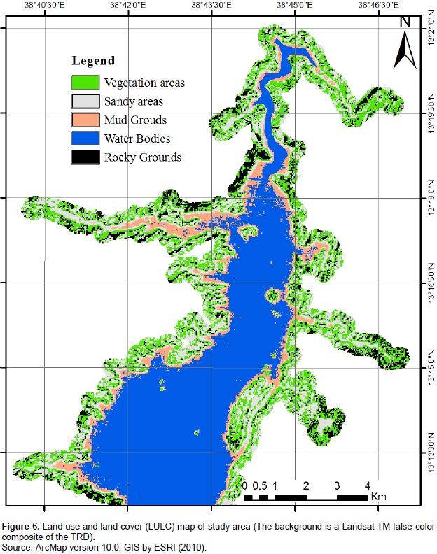
A Landsat TM5 satellite image, acquired on 10 November, 2011 was used to produce a map of all cover types in the study area. The classification of cover types adhered to a subset of the scheme used by Harvey and Hill (2003) with some modifications. These cover types considered were those specific enough to reflect the crocodile presences and sufficiently to include the habitat encountered in Tekeze River. Before the image classification, 4, 3, 2 and 1 band combinations was done to identify the vegetation from the other land cover types. This is because, once the vegetation were differentiated, it would be easy to identify the remaining land cover class. The resulting classification scheme having relevance with crocodile habitat suitability consisted of the following five land cover class:
1) Open water
2) Shoreline vegetation
3) Rocky ground
4) River banks with muddy ground
5) Shoreline sand beach.
Following this, a supervised image classification was done using ERDAS IMAGINE image–processing system for classification of satellites image into spectrally similar class. The accuracy level of image classification was done using 78 Ground control points sampled from the land cover classes. It has been able to maintain 87% of overall image classification accuracy results. The land cover map was then reclassified into five main classes, by giving a higher cell value for land cover classes which were assumed to be suitable for crocodile habitat. In the reclassification process, river banks were identified as the 1st suitable areas, sandy areas the 2nd, open water the 3rd, rocky ground the 4th and vegetations near shore line the 5th.
Deriving and reclassifying slope layer
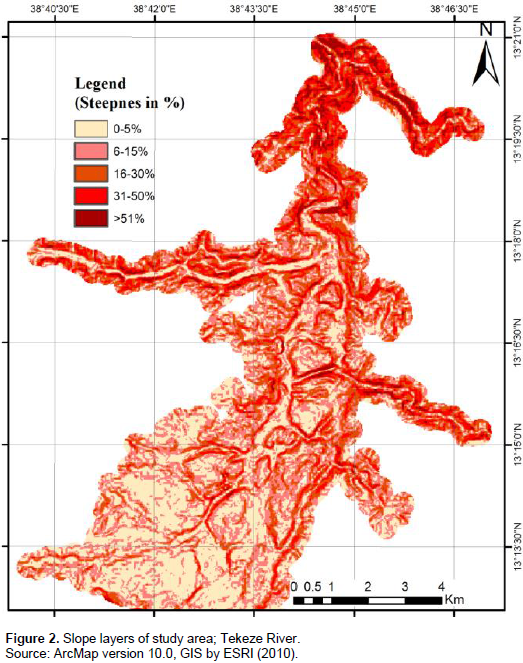
Slope layer was identified as one of the influential factor affecting habitat suitability and was incorporated in the model. The slope map of the areas was derived from 30 m resolutions of Digital Elevation Model (DEM) of the study area using the Spatial Analysis Tools (SAT) of Arc GIS 10 software. This was obtained from the United States Geological Survey. Assuming that flat areas were considered more suitable for crocodile habitat selection for the purpose of basking and nesting as well as searching prey while steep areas were considered as less suitable habitat for crocodiles. Accordingly, the slope layer was reclassified into five main classes by giving higher cell values to flat areas (having a steepness of less than 5%) and assigning lower cell values to less suitable slopes (Figure 2).

Developing and reclassifying distance to human interventions areas layers
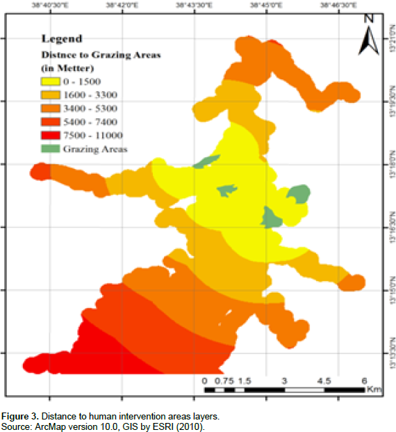
It was stated that human interventions would create disturbances on habitats suitability. C. niloticus habitat areas should ideally be far from areas where there were intense human activities. To take into account this factor in the model in terms of human interventions in the surrounding areas, the Tekeze River was delineated using GPS. Such areas include parts of the River where there were fishery activities, seasonal irrigated areas in the river banks, availability of grazing lands in the surrounds of the River while the River was used as source of livestock water point. Grazing is viewed as a disturbance for basking and nesting of crocodiles when performed at vicinity of crocodile habitats. Nesting sites were often trampled upon by cattle, either causing complete destruction of eggs or cattle run the risks of being attacked by crocodiles. The GPS data were imported into ArcGIS 10 software and a human intervention’s area as polygon layer was delineated using the GPS data. Based on this layer, distance to grazing areas was derived using the spatial analysis extension of ArcGIS 10 software (Figure 3). The layer was reclassified into five main classes, by giving higher cell values to those areas located farthest away from human intervention’s sites and areas closest to human intervention’s areas were given lower cell values.

Deriving and reclassifying distance to center of River layer
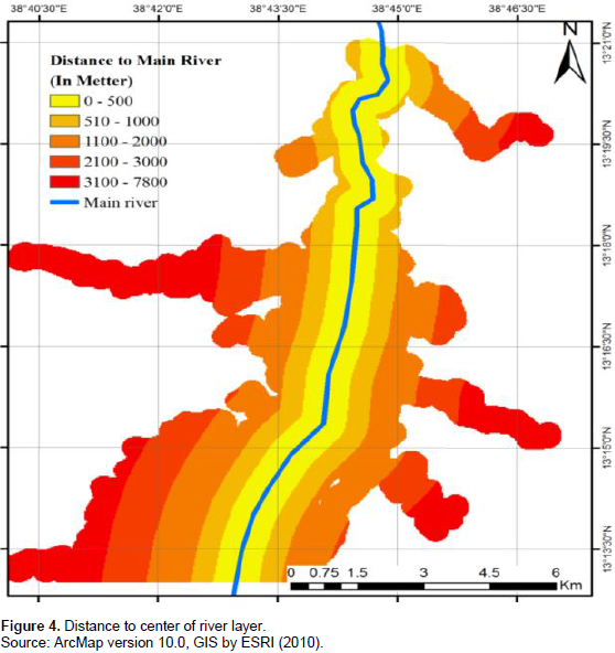
It is assumed that C. niloticus prefers to habitate in the shallow shorelines of the lake than the center of the lake where the depth of the lake was very high. Taking this into account, the main center of the lake was determined through field survey in combination with high resolution Google Earth Satellite Images. Thereafter, distance to the main center of the lake was derived based on this data using the spatial analysis extension of Arc GIS 10 software. This distance to main center of the river layer was reclassified into five main classes by giving 5 to the cells having the farthest away distance to the center of the lake whereas 1 was given to the cells having a closest distance to the shorelines of the lake (Figure 4).
Deriving and reclassifying distance to River shore line layer
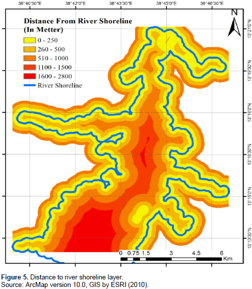
Since the shorelines of the river other than the main center of the river or hinter lands were preferred by crocodiles for habitation, therefore, the shorelines of the lake were delineated from high resolution satellite images. Distance to shoreline’s layer has been estimated and reclassified into five main classes (Figure 5). In doing so, areas found close to shorelines were assigned the highest cellvalues while areas found faraway to shorelines were assigned the lowest cell values.
Combining and weighting the layers
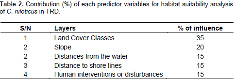
Using the weighted overlay tool element of the Arc GIS 10 spatial analysis extension, the above data sets were combined and weighed. In the weighting process, the following percentage of influence was maintained (Table 2). This has enabled production of the habitat suitability map of the area.
Data analysis
Data were recorded and entered to excel-spread sheet 2010 prior to applying data analysis. For each of the sites section surveyed, the total numbers of crocodiles, and their distribution with respect to habitat selection and relative density (individual number/km of surveyed area) were calculated. Crocodile sighting data were analyzed to show the distribution and habitat suitability of crocodiles over the study area using Arc GIS 10 software for windows. Total mean and standard deviations of crocodile presences were calculated for all age size-classes due to the small number of crocodiles encountered in each size class by surveyed zone. All statistical analysis was conducted using SPSS (SPSS 20.0 for windows). The attributes from georeferenced data were also presented and finally the spatial distribution and habitat suitability of C. niloticus in TRD were given.
Spatial distribution of Nile crocodile along Tekeze River Dam (TRD)
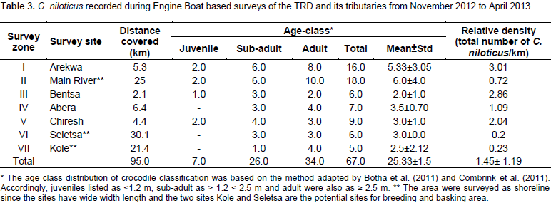
A total of seven stratified zones were surveyed to determine the abundances, distribution and habitat preferences of C. niloticus in the study area. In total, 67 individuals of C. niloticus were recorded in TRD and the distribution of crocodile along the major river and its branches were presented in Table 3. The distribution of crocodiles following age class was different along the entire survey of river stratum. The total mean and standard deviation of C. niloticus age-class distribution was 25.33±1.5 (Table 3). The relative density of C. niloticus in Arekwa sites was highest (3.01/km) and least in Seletsa River stratum (0.2/km).

Spatial distributions of land use and land cover in Tekeze River Dam
The results of land use and land cover classifications are presented in Figure 6. The latter was generated by Landsat TM5 satellite image. This map of land use and land cover of an area presents patterns of land utilizations and also to evaluate the coverage of micro-habitat types of crocodiles in study area. Accordingly, rocky grounds were found in Arekwa, Bentsa and on the edge of main River zones of the study area. Muddy and sandy river banks were most frequently found in inlet-river channels such as Abera, Arekwa, Seletsa, Bentsa and Chiresh zones of the study area. High vegetations coverage was mostly common in Kole and Seletsa River stratum. The accuracy level of overall image classifications result was 87%.
Habitat preferences and frequency of observation of C. niloticus
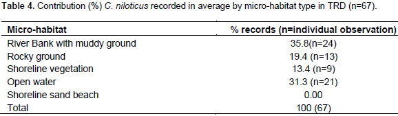
The average frequency of observations of C. niloticus in seven river zones was different by zone. The crocodiles encountered in the surveys were either from basking sites or in shallow water. Basking sites of C. niloticus includes the shallow water, rocky ground with gravel soil and muddy river banks as well as on the walls of Tekeze Dam crest. With respect to habitat selection, high frequency percentage (35.8%) was observed on river banks whereas lower frequency percentage was observed on shoreline with vegetations (13.4%) (Table 4). For the present surveyed sites, the open surfaces of the stratum represented the second most common micro-habitats where 31.3% of individuals were encountered. Furthermore, all crocodiles observed during the survey were found at the upper stream inlet site of the river basin between the gorges. Crocodiles were most frequently recorded in river banks which were found in inlet-like tributaries of Arekwa as well as Chiresh zones of the current study area. C. niloticus was also distributed in shallow water depth at shoreline of each river stratums.
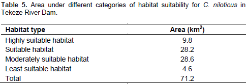
Habitat suitability analysis of C. niloticus in Tekeze River Dam
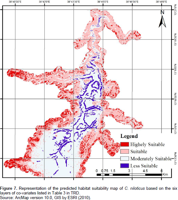
Along with the frequncy percentage of crocodile occurence and the suitablity of the habitat for C. niloticus, the spatial distribution of that specie was also analyzed in the study area (Table 5). The results show that among 71.2 km2 of the study area delinated, 9.8 km2 (13.75%) of the habitat data fell within areas classified as highly suitable while 4.6 km2 (6.5%) of habitat were under the least suitable habitat. Figure 7 represents the predicted habitat’s suitablity map of C. niloticus using the four layers covariates: landcover class, slope, distances from water, distances to shorelines and distances from human intervetions or disturbances. Areas of prediction of high occupancy or high suitability were found in central west, southwest and southeastern parts of the TRD and along its banks. However, the area along edges of other zones systems were considered as the least suitable habitat.
The priority steps towards proper conservation and management of C. niloticus in Tekeze River Dam (TRD) starts by evaluating the potential areas of distribution of the crocodile species and their habitat use. In the present study, a spatial distribution and habitat preference of C. niloticus were investigated through diurnal shoreline surveys and GIS mapping and remote sensing. The reason for surveying the land-water interface (shoreline and water’s edge) is based on the assumption that the crocodile population is easily counted when out of the water (Combrink, 2004) than in the water. In addition, crocodile populations are predators of the water's edge, inhabiting shorelines rather than open water, so that crocodilian habitat could be characterized as linear as opposed to occupying a surface area. This result is in agreement with the present findings. In the present study, 67 C. niloticus were recorded and found to be distributed randomly in the TRD throughout the surveyed area, especially in the main river channel and its six tributaries. Compared to other studies, the number of crocodiles’ occurrence were relatively small due to the remote character of the Tekeze River systems associated to constraints of logistical fieldwork.
The latter prevented the researcher to carry out the data collection during night time and in the whole Tekeze River Basin. The capacity to submerge in the water bodies and the nocturnal behavior of crocodiles has further contributed to hampering their detection. Thus, it is likely that increased sampling will detect more crocodile’s population (Brito et al., 2011) which in turn is important to identify their distributions and habitat preferences easily than in the present study area.Despite their irregular distribution, the study has shown that C. niloticus were mainly and frequently observed in the inlet river-like areas of Arekwa, Bentsa and Chiresh as compared to other sites. The current distribution locations of C. niloticus are similar to the distributions of micro habitat types that existed in TRD. This result is in agreement with the finding of Gandiwa et al. (2013) who found that the distribution of crocodiles were not uniform in Gonarezhou National Park of Zimbabwe and its river systems. This was likely due to habitat loss, siltation of inlet-river channel, frequent boat traffic and interaction with human for the communal resources such as fish, water sources for livestock and irrigation for crop growth. C. niloticus were mostly found in Arekwa River-channel which was probably related to high availability of prey resources such as fish, birds, and livestock as well as due to suitability of predation in the river strata.
Additionally, the irregular but common distribution patterns of the crocodiles in TRD such as the inlet of the tributaries river is probably due to the higher water levels caused by the raising of the dam wall. The latter covers the vast majority of the other shoreline areas in the dam which represented unsuitable habitats for crocodiles. Consequently, the crocodile population in the TRD was now concentrated in those found in-let tributary river areas wherein anthropogenic activities occurs frequently. In line with the present report, Botha et al. (2011) have shown that uneven distribution of crocodiles was observed in Olifants River of Loskop Dam due to increased water volumes. Bourquin (2007) has also reported similar argument in the Panhandle Region of the Okavango Delta, Botswana. He pointed out that when water levels rises and concentrates in main channels in dry season, crocodilians move out of main water into the surrounding floodplains or wetlands. Moreover, Ron et al. (1998) have also found that water level was the most important factor affecting the spatial distribution of crocodilians in the Amazon Basin.
This implies that most crocodiles remain in flooded forests during the rainy season and tend to retreat to the deepest areas of lakes when forced to do so by reducing water levels during the dry season. This indicated that there were spatial changes in distribution of crocodiles in TRD due mainly to the loss of suitable habitat driven by the increase of water levels along the dam wall. As a result, crocodiles are forced into areas where they would likely experience human-crocodile interactions than elsewhere in the river systems. Such loss of suitable habitat often leads to modification of spatial distributions of crocodiles and expose them to threats related to local people’s interactions and disturbances. Therefore, focusing on the study of habitat suitability represents an important factor to monitor and understand the rate of disturbances driven by crocodiles-human interactions so that methods to minimize the effects of disturbances can be developed at critical sites and habitats.
In general, the present result on habitat suitablity of C. niloticus in TRD showed that out of 71.2 km2 delineated area, 9.78 km2 was highly suitable habitat whereas 4.63 km2 was the least suitable one for C. niloticus activity’s pattern while the rest were considered as unsuitable area. Overall, this means the Tekeze River is a suitable habitat for the species activity patterns due to feed availability and proper environmental conditions. This means that in TRD, the C. niloticus are distributed and selected in habitats wherein anthropogenic activities are high such as in Arekwa River-channel. This indicated that even though animals use habitats in a specific manner, however, the costs and benefits of using specific habitat types remain unknown for many types of organisms. The reasons driving animals’ site selection are related to species-specific proximate responses to a wide range of biotic and abiotic factors that predict habitat suitability (Peterson, 2003). Other researchers have reported that C. niloticus use a wide variety of habitat types as an indication of an ontogenetic shift in diet including large lakes, rivers, and freshwater swamps and from insects and small aquatic invertebrates when young to vertebrate prey among larger crocodile (Wallace and Leslie, 2008; Fergusson, 2010).
In TRD, despite the disturbances, river bank habitats are highly preferred by C. niloticus for basking followed by open river surfaces which have shallow depths and low water current. This might be driven by the fact that the crocodiles use the river banks for dual functions such as for basking and nesting. This finding is also in agreement with the work of Graham (1968) who found that crocodile’s habitats are made of shoreline and littoral zones. Somaweera et al. (2011) have also found that most hatchlings of freshwater crocodiles (C. johnstoni) were found in floating vegetation mats or grassy banks rather than in the widely available open banks. Thus, it is important to develop habitat protection measures mainly on the basking and nesting areas to reduce the species-species conflict while conserving them at the same time.
The present study showed that there were no large variations among age-size classes of C. niloticus in the spatial distributions within survey zones of TRD. In the present study, the unusual aspect of the TRD crocodile population was the presence of different class sizes like juvenile, sub adult and adults basking together on the shore. However, it has been difficult to find evidence of cannibalism.
The results of the respondents and personal observations during the survey confirmed that more than five individual crocodiles of different size class were encountered together on river banks while basking. This may be an indication of absence of threat related to cannibalism among C. niloticus in TRD. On the contrary, several researchers have reported that C. niloticus were segregated based upon individual size-dependent differences to reduce intraspecific conflicts or cannibalism (Gary and Christopher, 1985; Hutton, 1989; Hutton and Child, 1989; Bourquin, 2007). Consequently, small-sized crocodiles were separated from large ones which appeared to be a natural ecological regulation mechanism and may also be a response to the threat of cannibalisms. Additionally, Hutton (1989) has clearly explained that adults become increasingly intolerant of intermediate-sized animals and suggested that size-class separation is part of a general density-dependent regulating mechanism in crocodilian populations but not in case of Tekeze. The availability of rich food and prey resources driven by low fishing activities might explain the previous trends. The absence of cannibalism in TRD may also be another reason in determining the population ecology of crocodile in the Tekeze River population. Hence, it is necessary to verify the behavior, molecular genetics and speciation of C. niloticus encountered in TRD.
The visual sightings of crocodile were observed mainly at basking, swimming, and submerged positions on different micro-habitat types. River banks with exposed sun-banks were the potential area for basking like in the Arekwa sites of river stratum. This might be due to the presence of potential prey resources as well as habitats with suitable environmental conditions for crocodile activity patterns. However, with the increase in cattle grazing, the presence of drinking water areas, river side agriculture, fishing practices, noise and waves created by the boat traffic for recreational and fishing purposes in Arekwa and other sites, it has been shown that the areas previously used by crocodiles for basking and nesting have been disturbed. Such activities might have affected the distribution and population size of the crocodiles. The latter obviously need to be contained in habitats such as basking and nesting areas.
Similar to the present finding, Zisadza-Gandiwa et al. (2013) have showed that human-wildlife conflicts on communal areas, pollution from agricultural activities upstream, and poor land use in the catchment leading to siltation and limited availability of prey resources have all contributed to affect crocodile population size and structures. Therefore, forcing crocodiles to sub- and/or non-optimal habitats can have catastrophic effects on the crocodile populations, alimentary behaviour, population recruitment, survival and rise up human-crocodile conflicts. For example, during the study, respondents have described the negative impacts of crocodile on local communities’ livelihoods due to attack and killing of the livestock and removal of fish from nets. As result, local communities hunt them as sign of retaliation. Similar trends were also reported from (Thomas, 2006; cited in Bourquin, 2007) in Botswana. He found that the habitats selected by the C. niloticus were also the exact locations preferred by the local communities for meeting their livelihoods needs. Overcoming such threats on local communities’ livelihoods calls for monitoring, interpreting and mapping the critical crocodile nesting areas, basking, feeding and juvenile habitats on a regular and systematic basis to develop innovative and balancing conservation and development initiatives in TDR area.
This study explored the distribution of C. niloticus and mapped out its potential habitat in Tekeze River. The C. niloticus registered in the main river and its tributary branches were not uniformly distributed. The visual sightings of crocodile were observed mainly at basking, swimming, seeking and submerged positions on different micro-habitat types. River banks with exposed sun-banks are the potential area for basking. Overall, main river stretches of Tekeze River were known by its large distribution of small and medium-sized classes of crocodile. There is no record of small-sized crocodile observed in Kole sites of study area. Along the 71.2 km² of the study area delineated for habitat preferences, 9.78 km2 was the highly suitable habitat while 4.63 km2 was the least suitable. The influence on communal resources, fishery activities and irrigation practice at small-scale on river banks and increment of water level due to flooding of the Tekeze River Dam were among the primary causes of disturbances induced by human to C. niloticus distribution and its habitats. Local communities along riverine systems of Tekeze Dam perceive C. niloticus as a sole enemy of their livelihoods and their property.
Further research needs to be conducted with regards to mapping of spatial and temporal analysis of C. niloticus distribution along the river systems with shoreline riparian vegetation classification of Tekeze River. Also, a combination of daytime and spotlight surveys will need to be conducted to know their status since the species is cryptic, secretive and nocturnal in its behavior. To overcome human-crocodile conflicts, it is necessary to monitor, understand and plan the critical crocodile nesting areas; also, basking, feeding and juvenile habitats on a regular and systematic basis are needed to develop the TRD area. It is therefore suggested that the success of conservation programs and habitats management should focus on educating the local community to raise awareness and change their attitudes towards promoting conservation development initiatives of C. niloticus in the area.
The authors have not declared any conflict of interests.
REFERENCES
|
Aarts G, MacKenzie M, McConnell B, Fedak M, Matthiopoulos J (2008). Estimating space-use and habitat preference from wildlife telemetry data. Ecography 31:140-160.
Crossref
|
|
|
|
Aramde F, Girma M, Tsegaye B (2011). Spatial distribution and habitat preferences of selected large mammalian species in the Nech SAR National Park (NSNP), Ethiopia. Nat. Sci. 9(3):80-90.
|
|
|
|
|
Botha H, Hoven W, Guillette L (2011). The decline of the Nile crocodile population in Loskop Dam, Olifants River, South Africa. Water SA 37(1):103-108.
Crossref
|
|
|
|
|
Bourquin S (2007). The Population Ecology of the Nile crocodile, Crocodylus niloticus, in the Panhandle Region of the Okavango Delta, Botswana. A thesis submitted in partial fulfillment of the requirements for the degree of Doctor of Philosophy Department of Conservation Ecology and Entomology Faculty of Agrisciences University of Stellenbosch (unpublished).
|
|
|
|
|
Brito J, Martı’nez F, Sierra P, Sillero N, Tarroso P (2011). Crocodiles in the Sahara Desert: An Update of Distribution, Habitats and Population Status for Conservation Planning in Mauritania. PLoS ONE 6(2):e14734.
Crossref
|
|
|
|
|
Combrink A (2004). Population survey of Nile crocodile, Crocodylus niloticus, at Lake Maya, Republic of South Africa. MSc. thesis, Pietermaritzburg.
|
|
|
|
|
Combrin X, Korrûbel J, Kyle R, Taylor R, Ross P (2011). Evidence of a declining Nile crocodile, Crocodilus niloticus, population at Lake Sibaya, South Africa. S. Afr. J. Wildl. Res. 41(2):145-157.
Crossref
|
|
|
|
|
Ekwal I, Hussain T, Tahir M (2012). Modeling of Habitat Suitability Index for Muntjak, Muntiacus muntjak, Using Remote Sensing, GIS and Multiple Logistic Regressions. J. Settlements Spat. Plan. 3(2):93-102.
|
|
|
|
|
Fergusson R (2010). Nile crocodile Crocodylus niloticus, In: Manolis SC and Stevenson C (eds.), Crocodiles: Status Survey and Conservation Action Plan, (3rd ed). Crocodile Specialist Group, Darwin. pp. 84-89.
|
|
|
|
|
Gary A, Christopher A (1985). A survey of intraspecific predation among reptiles and amphibians. J. Herpetol. 19(1):99-107.
Crossref
|
|
|
|
|
Harvey K, Hill G (2003). Mapping the nesting habitats of saltwater crocodiles (Crocodylus porosus) in Melacca Swamp and the Adelaide River wetlands, Northern Territory: an approach using remote sensing and GIS. Wildl. Res. 30:365-375.
Crossref
|
|
|
|
|
Hekkala E, Shirley M, Amato G, Austin J, Charter S, Thorbjarnarson J, Houck M, Desalle R, Blum M (2011). An ancient icon reveals new mysteries: mummy DNA resurrects a cryptic species within the Nile crocodile. Mol. Ecol. 20(20):4199-4215.
Crossref
|
|
|
|
|
Hutton J (1989). Movements, Home Range, Dispersal and the Separation of Size Classes in Nile Crocodiles. Am. Zool. 29 (3):1033-1049.
Crossref
|
|
|
|
|
Hutton J, Child G (1989). Crocodile Management in Zimbabwe. In: Crocodiles, their Ecology, Management and Conservation. IUCN - The World Conservation Union, Gland, Switzerland.
|
|
|
|
|
Ijeomah H, Efenakpo O (2011). Analysis of Nile crocodile, Crocodylus niloticus, hunting in selected communities around fresh water and salt water transitional areas of rivers state, Nigeria. Trop. Agric. Res. Ext. 14(4):81-84.
|
|
|
|
|
Leslie A, Spotila J (2001). Alien plants threaten Nile crocodile, Crocodylus niloticus, breeding in Lake St. Lucia, in South Africa. Biol. Conserv. 98(3):347-355.
Crossref
|
|
|
|
|
Leslie A, Lovely C, Pittman J (2011). A preliminary disease survey in the wild Nile crocodile, Crocodylus niloticus, population in the Okavango Delta, Botswana. J. S. Afr. Vet. Ass. 82(3):155-159.
Crossref
|
|
|
|
|
Peterson M (2003). A conceptual view of environment-habitat-production linkages in tidal river estuaries. Rev. Fish. Sci. 11:291-313.
Crossref
|
|
|
|
|
Ron S, Vallejo A, Asanza E (1998). Human Influence on the Wariness of Melanosuchus niger and Caiman crocodilus in Cuyabeno, Ecuador. J. Herpetol. 32:1-320.
Crossref
|
|
|
|
|
Ross J (1998). Crocodiles: Status Survey and Conservation Action Plan. IUCN, Gland, Switzerland.
|
|
|
|
|
Somaweera R, Webb J, Shine R (2011). Determinants of Habitat Selection by Hatchling A Freshwater Crocodiles. PLoS ONE 6(12):e28533.
Crossref
|
|
|
|
|
Wallace K, Leslie A (2008). Diet of the Nile crocodile, Crocodylus niloticus, in the Okavango Delta, Botswana. J. Herpetol. 42:361-368.
Crossref
|
|
|
|
|
Whitaker R, Whitaker N (2007). African Parks (Ethiopia) Nech SAR National Park Project Sustainable use of the Lake Chamo Nile crocodile population project document, Addis Ababa.
|
|
|
|
|
Zisadza-Gandiwa P, Gandiwa E, Jakarasi J, Westhuizen H, Muvengwi J (2013). Abundance, distribution and population trends of Nile crocodile, Crocodylus niloticus, in Gonarezhou National Park, Zimbabwe. Water SA. 39(1):165-169.
|
|