Changes in ecosystem functions can be analyzed through changes in land use land cover (LULC) systems. This study was carried out to analyze the LULC changes and perception of local community towards land cover change in the lowlands of Bale, Southeast Ethiopia using remote sensing data, field observations and perception of local people. The results showed that cultivated land, settlement, bush land and bare land expanded by 13.81, 14.30, 12.62 and 22.3% respectively, between 1986 and 2016, whereas wood land, grassland and shrubby grassland declined by 33.82, 24.4 and 3.36% respectively. Local communities’ perceptions indicate that climatic, demographic and anthropogenic factors as well as implementation of inappropriate government policy and development interventions were major driving forces of LULC dynamics. Environmental and local livelihoods implications such as rangeland degradation, bush encroachment, soil degradation, livestock loss, biodiversity loss and poverty increase resulted from these changes. Cumulative effects contribute to rangeland degradation and poverty. Therefore, to halt the impact of LULC disturbance and its implication on the likelihood of the pastoralist, appropriate management measures and government policies have to be implemented.
According to Dong et al. (2011), range land ecosystem supports over one billion herds of camel, cattle, sheep and goats and over 200 million pastoral households. Rangelands biomes encompassing much of the area where pastoral livestock production is a major land use, cover 51% of the earth’s land area (Mussa et al., 2016). Extensive livestock production is the main land use activity in rangeland areas, and due to this it’s been referred to as pastoral land. Curtin and Western (2008) and Mussa et al. (2016) describes rangeland to the specific values such as providing daily and seasonal forage, carbon sequestration, water resources, breeding grounds to wild animals and livestock which are some of the services from rangelands; while Little and McPeak (2014) describes rangeland ecosystem as an entail of various resources with many ecological, social and economic values.Globally, rangelands are under intense pressure from natural and human induced factor. Climate changes, demographic factors, crop focused policy, and investment policy are some of the factors attributed to land use land cover (LULC) changes in rangelands (Tsegaye et al., 2010; Abate and Angassa, 2016). Since 1950, about 10.7 million km2 of the world lands occupied by grassland and woodland have been changed to farmlands (Tsegaye et al., 2010; Kimiti et al., 2016).
The rapidly increasing of LULC changes in the rangelands of Ethiopia and the increased complexity of their drivers are presenting substantial problems for rangeland management. The magnitude of the changes can be quite different depending on the anthropogenic influences in specific areas (Roques et al., 2001; Mwavu and Witkowski, 2008). As such, the integrity of rangelands is subsequently declining with reduction in the quality and quantity of services they provide to dependent communities (Mussa et al., 2016). Monitoring LULC changes is essential for understanding vegetation dynamics and utilizations of natural resources in a sustainable manner (Gibbens et al., 2005). Such information is also very crucial to enhance the formulation of informed policies to support sustainable rangeland management and rehabilitation practices for increased natural resource protection, resilience of rangelands to changing climates and pastoral livelihoods (Zziwa et al., 2012).
Bale rangelands comprise of important cultural landscapes, and livestock has been an integral part of Bale landscape for many centuries. Decades ago, the Bale rangelands were considered as one of the most productive ecosystems. However in the 1970s, the largest loss of pastoral resources occurred with the establishment of the Bale Mountains National Park (Fiona et al., 2008). Anthropogenic and naturally induced factors are the prime causes for rangelands degradation (Abate et al., 2010), consequential it is disturbing the delivery of ecosystem services and goods (Caldas et al., 2015). These changes also affects livestock mobility, grazing areas and the conflicts over natural resources (Egeru et al., 2014). Restricted mobility is known to lead to increased grazing pressure that predisposes soil to erosion, and lowers rangeland productivity and livestock production (Msoffe et al., 2011).
Studies conducted on LULC changes gave more emphasis on analyzing LULC or on socio-economic surveys (Abate, 2011; Eyob et al., 2011; Amanuel and Mulugeta, 2014) rather than linking LULC changes with socio-economic surveys. For instance, according to Tsegaye et al. (2010) mapping spatial changes using remote sensing can only give quantitative descriptions than explaining the relationship of patterns of change and the driving forces. Meanwhile, understanding local community perception on LULC changes is crucial for designing effective land use plan (Wubie et al., 2016). Though studying spatial change of LULC using remote sensing tools and local community perceptions are vital for ensuring sustainable rangeland ecosystem management; thereby improving the livelihood of pastoralists in the region. However, studies on LULC changes through integrating remote sensing tools with the perceptions of local communities in lowlands of Bale rangelands are lacking. Therefore, this study was focused on analyzing LULC changes and perception of pastoralists on LULC changes in Raitu district of Bale rangeland of Southeast Ethiopia. And so the study was intended to examine the LULC changes between 1986 and 2016; and the perceptions of local community towards LULC changes in the lowlands of Bale rangelands, southeast Ethiopia.
Magnitude of LULC changes
The land use/cover change analysis made for the two consecutive periods 1986 to 2001 and 2001 to 2016 indicated that the rangeland was subject to considerable land use land cover changes (Table 2 and Figure 2). Seven major LULC categories: woodland, bushland, shrubby grassland, grassland, cultivated land, bare land and settlement were identified as depicted in Table 1. The results indicated that for the last thirty years studied, similar changes in LULC were seen for all land cover types except that of the shrubby grassland cover (Table 2 and Figure 2).Woodland was significantly reduced by 16.37% during the first phase (1986 to 2001), and by the rate of 20.87% during the second phase (2001 to 2016). In general, the woodland cover was decreased at a rate of 33.82% annually during the study period (Table 2). The results of this study are in line with several studies that documented a decline in wood vegetation cover in Ethiopian rangelands (Tsegaye et al., 2010; Belay et al., 2014; Yonas et al., 2016).
The present result indicates that the decline in woody vegetation was attributed to excessive human exploitation for firewood, charcoal production, construction and land clearing for crop production. This is also evident in most East African countries where areas under forest cover were converted to grazing land, farmland or used for charcoal production (Olson et al., 2004; Yonas et al., 2016). Similar trends have been observed in rangelands of southeast Ethiopia, and we are losing the most important woody species from time to time (Abate et al., 2010). Results also show that the bush land cover significantly increased by 3.35 and 8.98% during the first (1986 to 2001) and the second (2001 to 2016) phases of the study, respectively (Table 2) corroborating several studies conducted in arid and semi-arid rangelands (Takele, 2007; Tsegaye et al., 2010; Abate, 2011; Abate and Angassa, 2016) that showed the encroachment of bush. Bushland expanded annually at the rate of 12.63% during the study period (Table 2).Abate and Angassa (2016) reported the expansion of bushland in Borana rangelands, where the process negatively affects the livelihood of Borana cattle herders. Increase in bushland cover in Bale rangelands is also in agreement with previous reports (Walkaro, 2007; Abate et al., 2010). The increase in cover of bushland might be due to the ban of fire and continued human disturbances linked to overgrazing practices (Abate et al., 2010; Tsegaye et al., 2010; Abateand Angassa, 2016).
The shrubby grassland cover was significantly increased, by 2.93% during the first phase of the study (1986 to 2001), but showed rapid reduction at a rate of 6.1% during the second phase (2001 to 2016). Over all, the shrubby grassland cover showed significant decrease annually at a rate of 3.36% (Table 2). The decline in bushy grassland cover which is attributed to excessive human exploitation of the important woody species for firewood and construction, and land clearing for crop production (Yonas et al., 2016).Grassland cover was significantly decreased; by 16.6 and 9.4% during the first second phases of the study, respectively; that is, from 1044 km2 in 2001 to 946 km2 in 2016 (Table 2). Generally, the grassland cover showed rapid reduction at an annual rate of 24.4% during the study period (1986 to 2016) (Table 2). The rapid reduction in grassland cover was similar to previous reports from Afar and Borana rangelands (Tsegaye et al., 2010; Abate and Angassa, 2016).
The decline in grassland cover was observed due to ban of fire, bush encroachment, drought, expansion of cultivation, settlement and continued human disturbances linked to overgrazing practices (Abate et al., 2010; Abate and Angassa, 2016). On the other hand, the increase in grassland in different rangelands was reported from areas of the country, where the restoration activities by different government and non-governmental organisations (NGOs) were common (Elias et al., 2015). This suggests the importance of restoring degraded rangelands for improving grass cover (Walkaro, 2007; Abate et al., 2010) (Table 2). Results show that bare land cover was rapidly increased by 19.7 and 2.6% during the first and second phase of the study, respectively (Table 2). The bare land cover increased from 879 km2 cover in 2001 to 898 km2 in 2016 (Table 2).
Generally, bare land cover was increased at a rate of 22.3 % annually during the study period (Table 2). The result of this study is in agreement with the findings of previous studies from arid and semi-arid rangelands (Tegegn et al., 2011; Elias et al., 2015;Yonas et al., 2016), which reported high levels of bare soil in the rangelands.Cultivated land was substantially increased throughout the study periods; the expansion of cultivated land was higher by 1.41% in the first phase (1986 and 2001) than the second phase (2001 to 2016), which accounted for 5.99%. Between 1986 and 2016, the extent of changes in the cultivated land was considerably increased at a rate of 13.8% annually, from 1274 km2 cover of the landscape in 1986 to 1450 km2 in 2016 (Table 2). According to Fiona et al. (2008), the expansion of agricultural land is associated with increasing number of immigrants. Farmland expansion phenomenon is the characteristic of the country; during the past 30 years there were areas of high farmland expansion in Ethiopia (Tsegaye et al., 2010; Belay et al., 2014; Elias et al., 2015). Meanwhile, Ethiopian government has encouraged pastoralists to engage in agro-pastoral activities. This government policy and weakening of the local institutions are also intensifying factors for expansion of cultivation (Belay et al., 2014; Abate and Angassa, 2016).
Prior studies conducted in pastoral areas of Ethiopia, including pastorals of Bale, reported the change in pastoral way of life (Tsegaye et al., 2010; Elias et al., 2015). Thirty years back, livestock production was practiced by 94% of families and the inhabitants were totally pastoralists (Abate et al., 2010). This suggests that the Bale pastoral way of life is gradually shifting from more dependence on livestock keeping to crop cultivation in some locations. Settlements land cover was constantly increased both in the earlier phase (1986 to 2001) and second phase (2001 to 2016) of the study. Between 1986 and 2016, the extent of changes considerably increased at a rate of 14.3 % annually, from 1090.1 km2 cover of the landscape in 1986 to 1246 km2 in 2016 (Table 2). Government settlement policy, state sponsored resettlement policy and conflicts are responsible factors for increasing settlements. The state-sponsored resettlement program, which was meant to ensure food security of highland food insecure households, has relocated millions of such households to rangelands.
This resettlement policy has been pointed out as a major factor for increasing the land under settlement (Fiona et al., 2011; Mussa et al., 2016). For example, following the 1984 famine, large numbers of families from Hararghe have been moved to the Bale lowlands. Due to the differences in land use practices of new comers from local conditions, integrating them to the local situations is very difficult. Many of the newcomers are agriculturists, who have sped up the cultivation of land at the expense of pasture (Worku and Fiona, 2017). This study is in line with the previous work conducted in northern Afar, which reported high influx of migrants from the Tigray highlands, particularly after the severe 1984/85 drought (Tsegaye et al., 2010).
Causes of LULC changes
Majority of the respondents (36%) ranked climate related factors as the first order of importance. All types of land use and land cover including the services are highly affected by the rapidly changing world climate (Opdam et al., 2009). The effect of droughts on rangelands was widely reported by different scholars (Abate et al., 2010; Tache and Oba, 2010). Drought affects vegetation cover through suppressing grass and stimulating bush land cover, which in turn leads to a decline in grassland and shrubby grassland (Abate and Angassa, 2016). The alteration of original landscape highly affected habitat for grazers, and forced pastoralists to change the composition of their livestock. Moreover, droughts also have negatively impacted the landscape causing further degradation, as people sought alternative means of survival such as cutting of trees to prepare charcoal.
Further, the variation in inter-annual rainfall amount causes differences in vegetation cover mainly by altering the grassland state to the woodland and bushland states (Abate and Angassa, 2016). This has been observed in Ethiopia in the last 50 years as the annual average minimum and maximum temperature were increasing by about 0.25 and 0.1°C, respectively, every decade (INCE, 2001; Mussa et al., 2016). This is mainly adverse in arid environments as plant productivity is strongly dependent on rainfall variability (Angassa and Oba, 2008). Overall, climate variability is probably a potential driver of LULC and rangeland fragmentation.Tsegaye et al., (2010) and Abate and Angassa (2016) describe demographic factors related to population growth as among the underlying causes for LULC changes. Accordingly, 28% of the respondents classified the overall demographic factors as the second order of importance. The present results are in line with previous studies such as Abate et al. (2010) and WLRC (2016).
Census data indicate that the population in Raitu district increased from 33,163 in 2011 to 40,316 in 2014 (Misganew, 2014). This implies that demographic expansion and consequent agricultural expansion are the major driving forces of land use cover changes. This study also has identified that the continuing increase of human population brought substantial changes on existing rangeland resources mainly on the use of woody plants for construction purposes, fuel wood, and charcoal. About 15% of the respondents ranked anthropogenic factors (overgrazing, sale of firewood and charcoal extraction) as the third main driving forces. Similarly, census results confirmed the increase in livestock that is, the total number of livestock heads increased from 36,160 in 2000 to 69,906 in 2007 and 123,152 heads in 2016.
The results of this study are generally in agreement with those reported by Abate and Angassa (2016) and Tsegaye et al. (2010) which indicated the importance of anthropogenic factors in the observed changes. Other sources (Elias et al., 2015; Mussa et al., 2016; Wubie et al., 2016) also reported the change in LULC due to anthropogenic factors.Inappropriate government policies (that is, ban of fire, promotion of crop cultivation, settlement policies, and introduction of peasant association) and inappropriate development interventions (private investors and appropriation of private pasture lands) comprises of the consecutive ranks (Table 4). Angassa and Oba (2008) also reported inappropriate government policies as the main causes of LULC changes. Development interventions such as private investors and appropriation of private pasture lands were reported as the causes of the changes.
Impacts of LULC changes
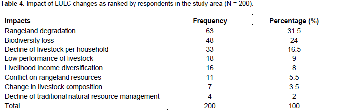
The pastoralists were well aware of the impacts of LULC changes and listed rangeland degradation (31.5%), biodiversity loss (24%), decline in livestock per household (16.5%), low performance of livestock (9%), diversification of livelihood income (8%), conflicts on rangeland resources (5.5%), change of livestock composition (3.5%) and decline of natural resource management institutions (2%) as some of the associated impacts. The results of this study are in line with a study conducted in lowland of Bale rangelands by Abate et al. (2010). According to Abate et al. (2010), the anthropogenic and increased human activities are the major factors causing degradation of rangelands in Raitu district. Shrinkage of grazing lands and the decline of grazing conditions due to the expansion of crop cultivation were also reported in the arid and semi-arid rangelands of Ethiopia (Abate and Angassa, 2016). According to the result of the study key informant interviews, the variety of pastures, diversity of habitats and tree cover declined due to the rising grazing pressure resulted from restricted herd movements and excessive utilization of natural resources. Disappearances of the preferred forage species reported by respondents indicate that the decline in quality of pasture as grazing area has deteriorated over time.
The study conducted by Abate et al. (2010) also indicated decline of important grass species due to grazing pressure in Raitu rangelands. Through influencing the traditional mobility pattern of movement between the wet and dry season, grazing area land use/cover changes affect ecosystem functioning in the rangelands. Consequentially, this may also lead to a decrease in the size of dry season grazing areas, isolation of crucial habitats such as permanent water sources, particularly for large wild animals, indirectly resulting in changing livestock species composition and directly disturbing some plant species that may be threatened with extinction. The decline of important woody plant species was mainly a consequence of intense livestock browsing (Tsegaye et al., 2010), indicating the severity of degradation. Most pastoralists no longer keep cattle, and are forced to rear small stock and camels that can utilize bush encroached areas (Abate and Angassa 2016).
In conditions where key resource dry-season grazing areas are encroached by agriculture, grazing-induced degradation often occurs in other areas as they are heavily utilized during the dry-season (Tsegaye et al., 2010; Daniel et al., 2017). The indigenous natural resource management practices, such as conflict is restricted due to the dynamics of the rangelands. In different pastoral areas of the country, the rangeland resources are changing from time to time due to inappropriate development interventions and inappropriate government policies (Abate and Angassa, 2016; Daniel et al., 2017). These changes resulted in a decline of indigenous natural resource management (Daniel et al., 2017) (Table 3).In addition, the shrinkage of rangelands from the aforementioned processes result in the conflicts of the pastoralists on rangeland resources (Bekele, 2010; Daniel et al., 2017). The rapid encroachment of agrarian community towards the rangeland ecosystem forced the pastoralists to lose their grazing land and livestock herds (Western and Nightingale, 2003; Okolle and Kioko, 2011). The changes forced pastoral households to switch to alternative livelihoods. Poverty, food insecurity, weak traditional institution, searches for alternative livelihood income and income diversification (that is, promotion of cultivation, petty trade, and changes in composition livestock species) were also some of the associated impacts.

The results of this study findings showed considerable dynamics in land use land cover between1986 to 2016 (last 30 years). Cultivated land, settlement, bush land and bare land expanded by 13.81, 14.30, 12.62 and 22.3%, respectively; whereas, woodland, grassland and shrubby grassland declined by 33.82, 24.4 and 3.36%, respectively. Climatic, demographic and anthropogenic factors as well as inappropriate government policy and inappropriate development interventions were major driving forces. The LULC dynamics has critical implications on the deterioration of rangeland, biodiversity loss, bush encroachments, decline of livestock asset at the household level, change in composition of livestock, soil erosion, and shortage of firewood and construction materials.
The dynamics in LULC also negatively affect the key pastoral resources, which in turn greatly affects pastoral community livelihood, and puts the pastoral production system under increasing threat. The loss in key pastoral resources increasing from to time due to the rapid encroachment of bush, settlement and cultivation of potential grazing lands (shrinkage of key pastoral resources) will increase, unless strong measures are taken. Addressing socio-economic and environmental challenges of the local areas as part of a solution to the surface problem of LULC changes in rangelands is very crucial. For sustainable rangeland management, incorporating indigenous and scientific information is very crucial. In the future, analysis of the changes in vegetation and soil from different land use, and analyzing vegetation changes using multi-temporal satellite data are highly recommended. Analysis of land use suitability and land potential are also very crucial to guide policy makers.