ABSTRACT
Geotechnical tests were carried out on twenty subsoil samples obtained from ten locations at the depth of 1 and 2 m within Federal University of Technology, Akure, Nigeria. The area is typical of basement complex. The test include; Natural Moisture Content, Grain Size Analyses, Specific Gravity, Atterberg Limits, Compaction, California Bearing Ratio (CBR), and Unconfined Compression Tests. The ten locations where the soil samples were collected were selected across the geological classification of the area. ArcGIS 10.1 software was used to generate maps showing the geotechnical parameters distribution across four geological formations within the area at 1 and 2 m depth. It was observed that the distribution of each geotechnical parameter correlates with the composition of the weathering end-product of the geology. The rocks underlain the area includes; Migimatite Gneiss, Quartzite, Charnockite and Biotite Granite. The poorest geotechnical parameters were obtained within subsoil underlain by Charnockite, hence are most unsuitable soil to host the foundation of civil engineering structures, while the area underlie by weathering end-product of quartzite rock is of good geotechnical parameters and most suitable soil to host the foundation of civil engineering structures. The weathering end-products of Charnockite, Migimatite and Granite rocks give relatively high shear strength than that of quartzite, indicating low cohesive nature of the weathering end-product of quartzite.
Key words: Geological classification, geotechnical parameter, weathering, road base.
Civil engineering structures are founded on or within the earth. Construction of these structures requires prior investigation of the chosen site in order to derive a good knowledge of the subsoil properties. Lack of the good knowledge of the properties of the subsurface materials leads to the failure of most engineering structures especially roads and buildings. Therefore, it is of great importance to carry out pre-construction study of a proposed site to ascertain the fitness of the host earth material. The pre-construction investigation may involve direct mechanical boring, pitting and trenching for subsoil sequence delineation, groundwater table mapping, soil sampling, and geotechnical laboratory analysis. It may also involve non-invasive geophysical investigation (Olorunfemi et al., 2010). For several decades, geotechnical analysis has become increasingly useful in subsurface engineering study to obtain information about the physical and engineering properties of the subsoil which may include the strength, stability and competence of the material that make up the subsoil materials, especially the shallow section which serves as host for foundations of engineering structures (Aina et al., 1996; Adewumi and Olorunfemi, 2005; Idornigie et al., 2006). This information helps the engineers to correctly locate and design the foundation of engineering structures. The information also serves as guide to the choice of design and suitable materials needed for road construction (Akinlabi and Adeyemi, 2014). The research is aimed at generating maps that will show the distribution of some important geotechnical parameters that are valuable for infrastructure development planning. This will be related to geological distribution within basement complex. The needs to evaluate the subsurface condition as related to geological formation for appropriate location of civil structures, proper designing of the foundation of civil structures has necessitated the present research. The study will reveal the distribution of geotechnical parameters across the various geological classifications.
Description of the study area
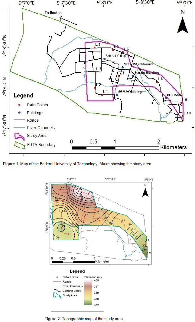
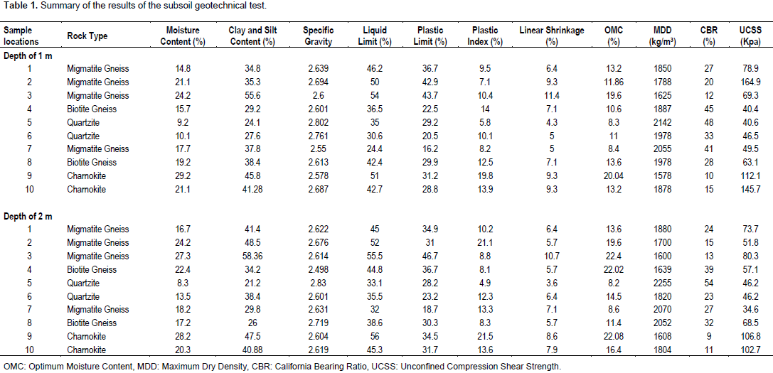
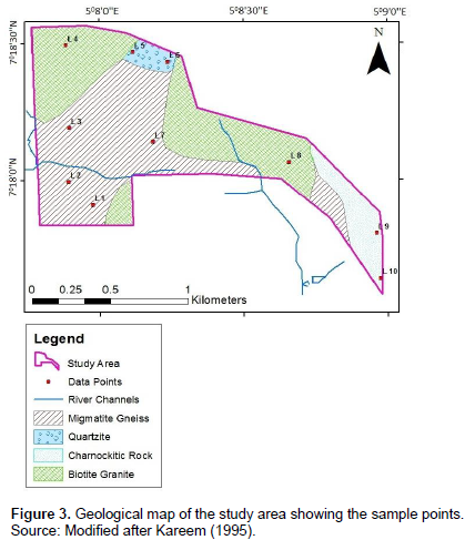
The study area is a part of the Federal University of Technology, Akure Nigeria. The University is situated on the northwestern flank of Akure and occupies an area of about 5 km2 lies between Latitudes 7°17’0’’N – 7° 19’0’’N and Longitudes 5° 7’0’’E - 5° 9’0’’E (Figure 1). The topography indicates a general gentle slope with gradual increase in elevation from the east and south towards the north-western part of the area (Figure 2). It has an elevation ranging between 372 and 405 m above mean sea level. There are some stream channels trending approximately east-west and north-south direction. The area is characterized by dry (November to March) and wet (April to October) seasons and mean annual rainfall ranging between 1000 and 1500 mm. The annual mean temperature ranges from 21.9 to 30.4°C. Humidity is relatively high during the wet season and low during the dry season with values ranging annually from 39.1 to 98.2% (Akinbode et al., 2008). The vegetation is of tropical rain forest which is characterized by thick forest. The area is underlain by rocks of the Precambrian Basement Complex of Southwestern Nigeria (Rahaman, 1989). The dominant rock types are Granite, Charnockite, Quartzite and Migmatite-gneiss (Figure 3). A quartzite ridge that extends over 100 m is located on the northern part of the area. However, Charnockites occur as discrete bodies mainly in the eastern part. Outcrops of migmatite-gneiss occur around the central and the southwestern part of the area. Granites occur as intrusives or lowlying outcrop within the migmatite-gneiss. Field observation however shows that the granite rocks constitute extensive rock outcrops in the northwestern and northeastern part of the area. The geology and boundaries of lithological units were inferred in places where they are concealed by superficial residual soil (Kareem, 1995).

The research methodology consist of both field and laboratory investigations. The field investigation involves visitation to the study area with the aim of establishing the various geological classifications and boundaries. Ten sampling points were selected across the area based on the geological classifications. Disturbed soil samples were taken at the depth of 1 and 2 m at each sampling points, resulting to a total of twenty (20) soil samples. These were preserved in polythene bags and transported to the laboratory. The Natural Moisture Content (NMC) of the subsoil samples was determined in the laboratory within the period of 24 h after collection. This was followed by Unconfined Compression Strength (UCS) test on a small portion of the soil samples from each location. The rest of the soil samples were air dried by spreading them out on trays in a fairly warm room for four days. Large soil particles (clods) in the samples were broken with a wooden mallet. Care was taken not to crush the individual particles. All the methods employed in carrying out the geotechnical test complied with the procedures specified by the British Standard Institution BS 1377 (1975). The other tests carried out on air dried samples include Grain Size Analysis, Specific Gravity, Consistency (Atterberg) Limit, Compaction Test, and California Bearing Ratio. The change in weight of wet samples put in a can after oven drying were measured and recorded for moisture content test. Sieve analysis test was conducted on oven dried soil samples using set of sieves with mesh size ranging from 4.75 to 0.075 mm after the soil samples have been washed off using sieve with mesh size 0.425 and 0.063 mm which is believed to have removed the clay and silt content.
The specific gravity of the soil samples were also determined by obtaining the ratio between the weight of each soil samples and the weight of equivalent volume of water. A Cassagrande device, grooving tool and a spatula were used in the determination of the plastic and liquid limits of the moist soil samples. The moist samples were also placed in a shrinkage mould and oven dried in order to determine the linear shrinkage limits of the soil samples. Compaction test was done on each of the soil samples using modified protor method that employs 4.5 kg rammer and 5 layers with 25 blows per layer. 6 kg of air dried soil sample was measured and water content of the percentage Optimum Moisture Content (OMC) obtained from the compaction test was added to each soil sample. The wet soil sample was compacted in five layers in the mould by giving each layer 55 uniformly distributed blows of 4.5 kg rammer. From this, California Bearing Ratio (CBR) test was carried out using the CBR compression machine. A fairly moist soil sample was compacted in an unconfined compression mould after it has been lubricated with a petroleum jelly. The cylindrical shaped compacted soil of diameter 5.0 cm and height 8.8 cm was used after a period of 24 hours to conduct Unconfined Compression Strength (UCS) test with the aid of the CBR compression machine. The determined geotechnical parameters of the subsoil samples at the depth of 1 and 2 m for each of the ten locations was used to generate geotechnical parameter distribution map across the geological classification within the study area at both depths.
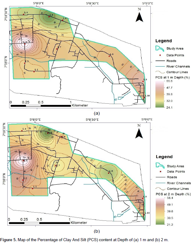
Table 1 show the summary of the geotechnical test results in the study area.

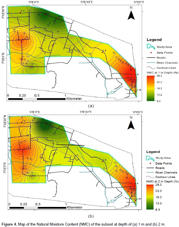
Natural moisture content (NMC)
The natural moisture content (NMC) at the depth of 1 and 2 m ranges from 9.2 to 29.2% and 8.3 to 28.2% respectively. The moisture content values are generally high, and may be due to the fact that, the samples were taken during raining season in May, 2017. The highest moisture content (>20%) was observed at south-eastern part of the area (Figure 4), which is underlain by charnockitic rock (Figure 3). The weathering end-product of charnokite is generally clayey, which is porous but less permeable with tendency of retaining high water content and may have resulted in the high natural moisture content obtained within the south-eastern part of the area. Lowest moisture content values (8.3 to 13.5) were obtained within the area underlain by quartzite (Figure 3). This may be due to the fact that sandy soil which is the weathering end-product of quartzite is porous and permeable, and hence, water drains and percolates easily within it.
Particle size analysis
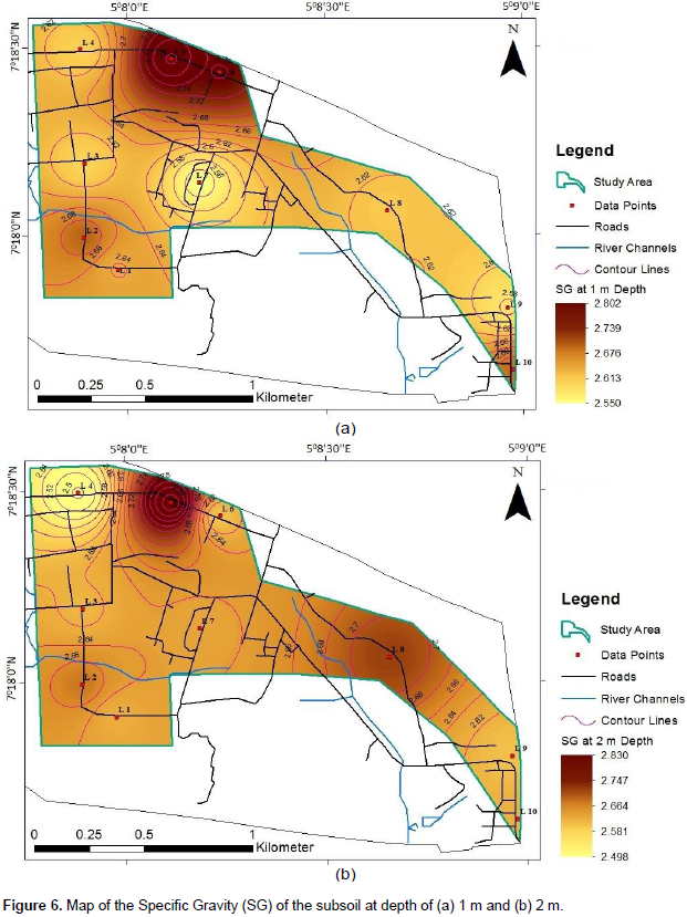
The subsoil at depths 1 and 2 m have percentage passing 0.075 mm sieve ranging from 24.1 to 55.6% and 21.2 to 58.4% respectively (Figure 5). The percentage of soil passing through sieve 0.075 mm is the percentage of clay and silt content contained within the soil. The percentage passing 0.075 mm in the area are higher/slightly higher than the maximum percentage (35%) recommended (Federal Ministry of Works and Housing (FMWH), 1972) for a good subsoil material for civil eniginering construction purpose. This correlates with the geology of the study area. The lowest value (21.2%) (Table 1) of the percentage passing 0.075 mm sieve was obtained within the area underlain by quartzite (Figure 5), showing that the weathering end-product of quartzite is sandy. Higher values were obtained within the areas underlain by migmatite gneiss and charnockite, which shows that the subsoil within this region is more clayey with the tendency of higher water ratention capacity.

Specific gravity test
The specific gravity of soil increases with increasing compaction and decreasing porosity and compressibility. Therefore soils with high specific gravity have good load bearing capacity and strength. The specific gravity values in the study area range from 2.55 to 2.802 and 2.5 to 2.83 at 1 and 2 m respectively (Figure 6). Relatively high specific gravity values were obtained within the areas underlain by quartzite, while areas underlain by other rocks were having relatively low values (Figure 6). This indicates that, the weathering end-product of quartzite is of higher load bearing capacity than the weathering end-product of other existing rocks within the area.

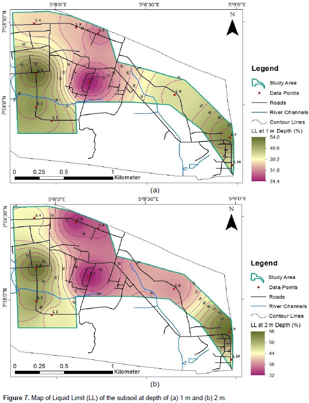
Liquid Limit (LL)
As shown in Figure 7, the Liquid Limit of the subsoil at the depth of 1 and 2 m range from 24.4 to 54% and 32 to 56% respectively. High liquid limit values are indicative of poor engineering and geological properties of subgrade soils (Jegede, 1995). Liquid Limit of 50% maximum (FMWH, 1972) is recommended for sub-grade material for engineering constructions, and most of the soil samples fall within this value. Therefore the soil can be said to be relatively good to host foundation of any civil engineering structure. However, the subsoil appears to be less competent at the south-eastern and western parts of the area due to the high Liquid Limit values within the regions (Figure 7). The regions are underlain by migmatite and charnockite with higher clayey material as weathering end-product than quartzite; hence weathering end-product of quartzite rock presents more favorable engineering characteristics than other rock types in the area.

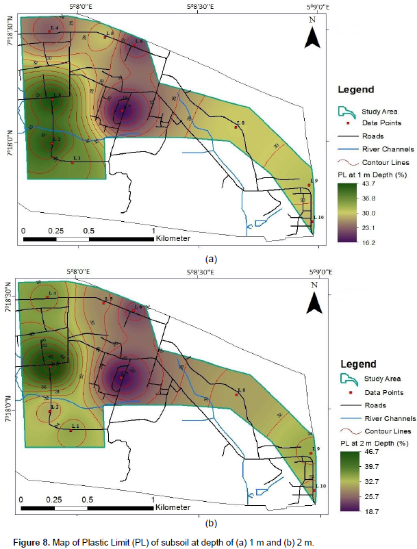
Plastic Limit (PL)
Generally, soils having high values of Plastic Limits are considered as poor foundation materials (Akintorinwa and Adeusi, 2009). The Plastic Limit (PL) of the subsoil at the depth of 1 and 2 m ranges from 16.2 to 43.7% and 18.7 to 46.7% respectively (Figure 8). Plastic Limit of 30% maximum is recommended for sub-grade material for engineering constructions (FMWH, 1972). Most of the tested subsoil falls within this recommended value (Table 1). The high value of Plastic Limit (Figure 8) at southwestern part of the study area must be taken into cognizance in erecting any civil structure foundation within the area (Figure 8). The Plastic Limit did present no correlation with any particular geology, but the high values were obtained within the area underlain by migmatite.
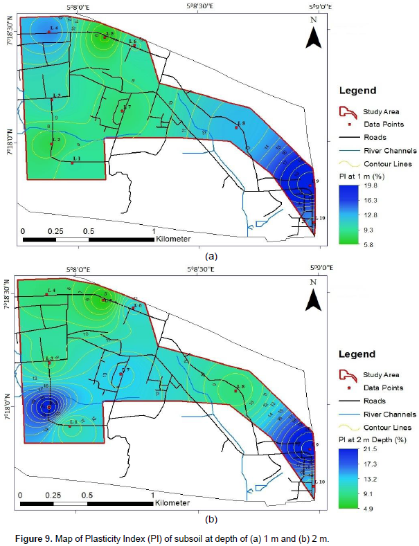
Plasticity Index (PI)
The plasticity index (PI) of the subsoil at the depth of 1 and 2 m ranges from 5.8 to 19.8% and 4.9 to 21.5% respectively (Figure 9). FMWH (1972) recommended Plasticity Index of 20% maximum for sub-grade material for engineering constructions. The Plasticity Index of the soil samples mostly fall within the recommended range. According to Cassagrande (1972), such soil can be said to be of low to medium compressibility and are therefore suitable for civil engineering construction. Plasticity Index (PI) values slightly higher than 20% were obtained at locations 2 and 9, at the depth of 2 m. Soil samples from these two locations are of relatively higher compressibility and falls within Charnockite and migmatite lithological units. The lowest value was obtained on subsoil underlain by quartzite rock.
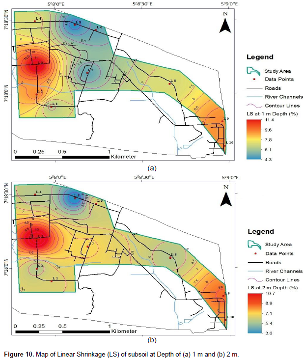
Linear Shrinkage (LS)
The knowledge of the Linear Shrinkage of soil is very essential in certain geographical areas where soil undergo large volume change when going through wet and dry season’s cycle. Generally, the lower the Linear Shrinkage of soil the lesser the tendency of the soil to shrink when desiccated. The Linear Shrinkage of all the soil samples tested range from 4.3 to 11.4% and 3.6 to 10.7% at 1 and 2 m respectively (Figure 10). Linear Shrinkage value ≤ 8% is indicative of a soil that is good for sub grade material for engineering construction (Brink et al., 1992; Madedor, 1983). Most of the soil samples fall within the neighborhood of this recommendation. Migmatite and the Charnockite rocks while the lowest value is within the quartzite rock (Figure 10). Migmatite and the Charnockite rocks while the lowest value is within the quartzite rock (Figure 10). Migmatite and the Charnockite rocks while the lowest value is within the quartzite rock (Figure 10). The weathering end- product of Migmatite and Charnockite rocks usually contains high percentage of clay than other rock types and they consequently have more tendencies to shrink.

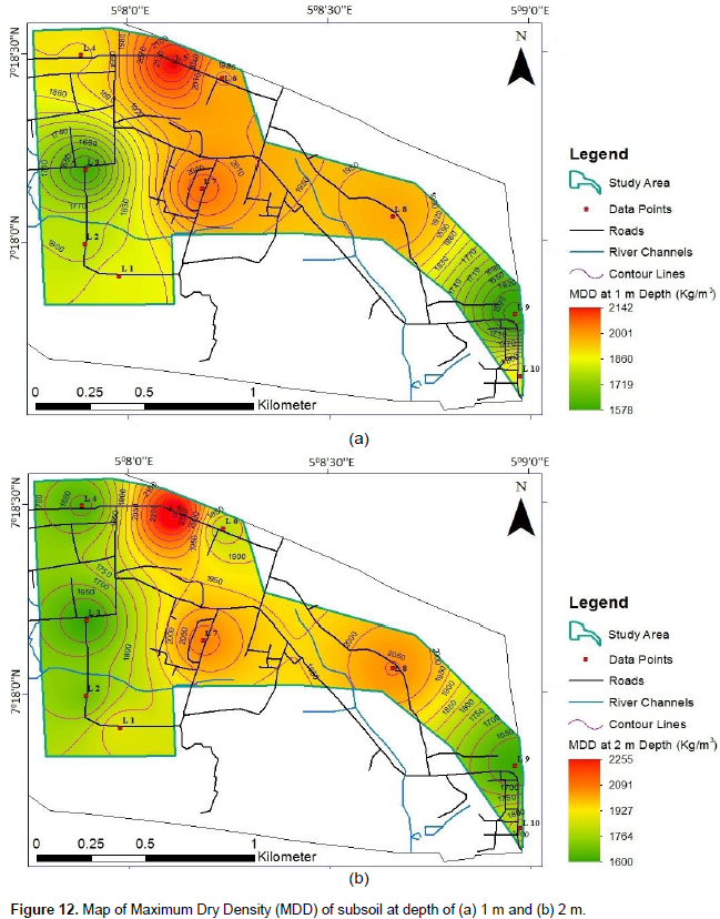
Compaction characteristics
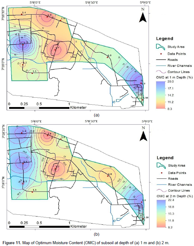
The importance of compaction test is to improve the desirable load bearing capacity properties of a soil (Akintorinwa and Adeusi, 2009). The degree of compaction is sensitive to moisture content. The best subsoil for foundation of engineering structures is that with high Maximum Dry Density (MDD) at low OMC (Jegede, 1999). The Optimum Moisture Content (OMC) values of the soil samples at 1 m depth range from 8.3 to 20.04%, and that of 2 m depth range from 8.2 – 22.08% (Figure 11). It was observed that soil samples within quartzite (Figure 11) have the least OMC, while the high OMC values were obtained within the area underlain by Charnockite, Granite and Migmatite (Figures 2 and 11). The MDD is the density of the soil at which any further increase in the moisture content leads to a reduction in the unit weight of the soil. The MDD values ranges from 1578 to 2142 kg/m3 and 1600 to 2255 kg/m3 at depths of 1 and 2 m (Figure 12). It was also observed that the subsoil within quartzite with the least OMC (8.2 and 8.6%) have the highest MDD (2055 and 2255 kg/m3). The highest OMC (19.6 and 22.4%) have the lowest MDD (1578 and 1625 kg/m3) was obtained within Migmatite and Charnokite (Figures 2, 11 and 12). This implies that quartzite rock have better compaction characteristics than other rocks. The weathering end-product of rocks that are clayey may have poor compaction characteristics.

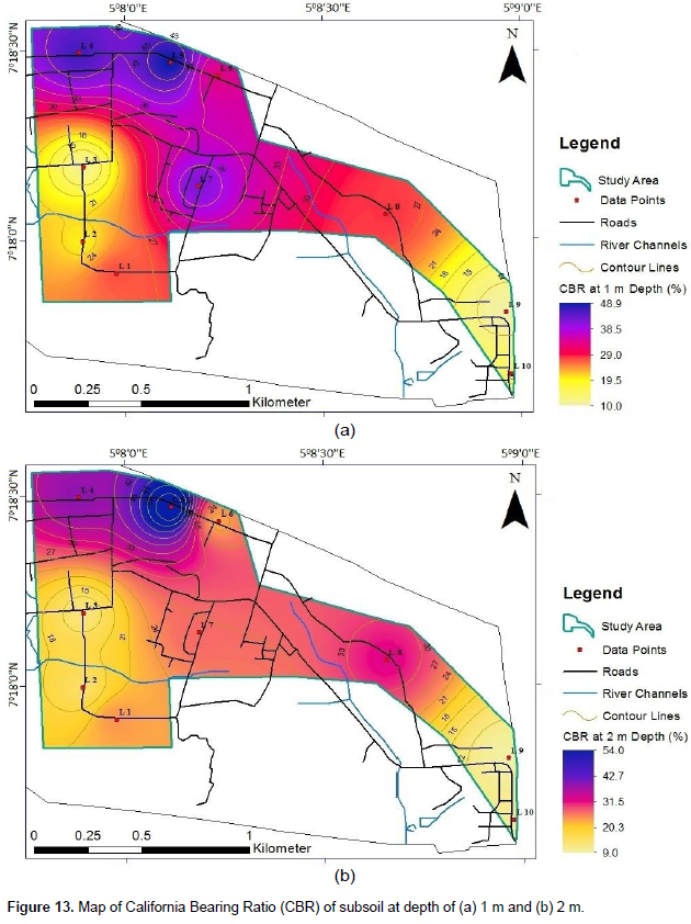
California Bearing Ratio (CBR)
California Bearing Ratio (CBR) is a test designed to assess the strength of soil. The California Bearing Ratio (CBR) of the subsoil at the depth of 1 and 2 m range from 10 to 48% and 9 to 54% respectively (Figure 13). The standard specification of CBR recommended according to FMWH (1972) is 80% minimum for subgrade materials for road construction in Nigeria. The CBR test results has shown that none of the soil samples tested has CBR value up to 80% minimum recommended for road construction. This cuts across all the lithological units but high value was obtained within area underlain by quartzite (Figure 13).
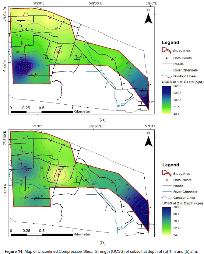
Unconfined Compression Shear Strength (UCSS)
The unconfined compression strength test is highly reliant on the cohesive qualities of the binder of the soil particles resulting from the clay content. The unconfined compressive shear strength ranges from 40.4 to 164.9 Kpa for the soil at the depth of 1 m, while it ranges from 34.6 to 106.8 Kpa for soil at the depth of 2 m (Figure 14). These soils can be classified as medium to stiff subsoil. The south-eastern and south-western parts of the study area where the subsoil have relatively high percentage of clay content have high UCSS values, hence high cohesive quality of binder material; whereas, reverse is the case for other parts of the study area. The lowest value at the depth of 1 m was obtained within area underlain by quartzite rock (Figure 14a). The weathering end-product of quartzite may not be suitable as binding material for its low cohesive nature.
The geotechnical tests include; natural moisture content, grain size analyses, specific gravity, Atterberg limits, compaction, California bearing ratio (CBR), and unconfined compression tests was conducted across four geological formations in a typical Basement complex. The rock includes; Migimatite Gneiss, Quartzite, Charnockite and Biotite Granite. The obtained results show that the geotechnical parameters correlate with the weathering end-product of the geology. The poorest geotechnical parameters were obtained within subsoil underlain by Charnockite, hence are most unsuitable soil to host the foundation of civil engineering structures, while the area underlie by weathering end-product of quartzite rock is of good geotechnical parameters and most suitable soil to host the foundation of civil engineering structures. The weathering end-products of Charnockite, Migimatite and Granite rocks give relatively high shear strength than that of quartzite, indicating low cohesive nature of the weathering end-product of quartzite.
The authors have not declared any conflict of interests.
REFERENCES
|
Adewumi I, Olorunfemi MO (2005). Using Geoinformation in Construction Management. J. Appl. Sci. 5(4):761-767.
Crossref
|
|
|
|
Aina A, Olorunfemi MO, Ojo JS (1996). An Integration of Aeromagnetic and Electrical Resistivity Methods in Dam Site Investigation. Geophysics 61(2):349-356.
Crossref
|
|
|
|
|
Akinbode OM, Eludoyin AO, Fashae OA (2008). Temperature and Relative Humidity Distributions in a Medium-Size Administrative Town in Southwest Nigeria. J. Environ. Manage. 87(1):95-105.
Crossref
|
|
|
|
|
Akinlabi IA, Adeyemi GO (2014). Determination of Empirical Relations between Geolectrical Data and Geotechnical Parameters in Foundation Studies for a proposed Earth Dam. Pacific J. Sci. Technol. 15(2):278-287.
|
|
|
|
|
Akintorinwa OJ, Adeusi FA (2009). Integration of Geophysical and Geotechnical Investigation for a Proposed Lecture Room Complex at the Federal University of Technology Akure, South-western Nigeria. Ozean J. Appl. Sci. 2(3):1943-2429.
|
|
|
|
|
Brink ABA, Parridge JC, Williams AAB (1992). Soil Survey for Engineering Clare, Oxford, 3739g. pp. 1-22.
|
|
|
|
|
BS 1377 (1975). Methods of Tests for Soils for Civil Engineering Purpose, British Standard Institution HMSO London.
|
|
|
|
|
Cassagrande A (1972). Classification and Identification of Soil Transaction ASCE, Vol. 113 New Yolks.
|
|
|
|
|
Federal Ministry of Works and Housing (FMWH) (1972). Highway Manual Part 1 Road Design, Federal Ministry of Works and Housing, Lagos.
|
|
|
|
|
Idornigie AI, Olorunfemi MO, Omitogun AA (2006). Integration of Remotely Sensed and Geophysical data Sets in engineering Site Characterization in a Basement Complex area of Southwestern Nigeria. J. Appl. Sci. Res. 2(9):541-552.
|
|
|
|
|
Jegede G (1995). Soil Erosion by Water, its Effect on Highway Pavement Failures in South-western Nigeria. Proceeding UNESCO-MAB Regional Training Workshop, FUTA. pp. 319-322.
|
|
|
|
|
Jegede G (1999). Engineering Geological Significance of the Superficial Deposits in Carrington Hill Area, Country Conc, Ireland. Nig. J. Sci. 28:153-158.
|
|
|
|
|
Kareem WA (1995). Geological Map of Federal University of Technology, Akure. Unpulished M. Tech (Doctoral dissertation, Thesis, Dept of Applied Geology, Federal University of Tech. Akure).
|
|
|
|
|
Madedor AC (1983). Pavement Design Guidelines and Practice for Different Geological Area in Nigeria. In: Ola SA (Ed) Tropical Soil of Nigeria in Engineering Practice. AA Balkema Rotterdam, pp. 291-297.
|
|
|
|
|
Olorunfemi MO, Akintorinwa OJ, Iginla IB, Bayowa GO (2010). Micro-Resistivity Measurements, Near-Surface Sequence Delineation, and Empirical Relationships with Engineering Geotechnical Parameters. Pacific J. Sci. Technol. 11(1):537-544.
|
|
|
|
|
Rahaman MA (1989). A Review of the Basement Geology of Southwestern Nigeria. In: Kogbe, C.A. (Editor). Geology of Nigeria. 2nd Revised Edition. Rock View (Nig.) Ltd.: Jos, Nigeria pp. 39-56.
|
|