ABSTRACT
Fuel wood remains the main energy source for the majority of the people in Gechi District of South Western Ethiopia. As compared to the situation in the past, the forest cover is now generally very sparse in the densely populated areas where rapid rates of deforestation and forest degradation have occurred due to the heavy demand on forest products, mainly fuel wood. Therefore, this study was conducted with the objective of assessing the impact of fuel wood consumption on the forest resources in Gechi district. The vegetation sampling was conducted in the Chara forest to determine the average volumes of the standing trees per hectare on systematically laid plots along transects. In each plot, data were collected on tree species, plant height, diameter at breast height (DBH) and volume of standing trees per hectare was determined and compared with the household fuel wood consumption. The study revealed that 6529.90 tons of fuel wood had been utilized in Chara, while the standing forest was 10593.75 tons on 125 ha of land implying that 1.76 ha of forest resources was consumed per annum for fuel wood by the community members. The most preferred and extracted tree species from the forest resources of the area for fuel wood were Syzygium guineense, Maesa lanceolate and Albizia gummifera. In order to address the forest resource degradation of the area due to fuel wood utilization as energy sources, the use of efficient energy saving technologies, planting fast growing tree species for use as fuel wood are recommended.
Key words: Deforestation, energy, fuel wood, forest.
Ethiopia has 11.2% or about 12,296,000 ha of forested land and had 511,000 ha of planted forest. Between 1990 and 2010, Ethiopia lost an average of 140,900 ha or 0.93% per year. In total, between 1990 and 2010, the country had lost 18.6% or around 2,818,000 ha of its forest cover (FAO, 2010).
The population pressure and agricultural expansion in Ethiopia had increased the forest resources utilization for construction and fuel wood, wood, etc. Hence, different forms of unsustainable forest utilization had been taking place including fires, encroachment, logging, cultivation, urbanization in coming decades ultimately leading to reducing the forest cover (Mekonnen and Kohlin, 2009). Estimates of the rates of deforestation indicated that 75% of forest losses are attributable to agricultural expansion. It is estimated that over the next 25 years the agriculture sector will require an additional 250 to 300 million hectares of new land to accommodate the demands of commercial farming, subsistence cropping, pasture and range development. Most of this increase in land area will come at the expense of forest lands (Dessie and Kleman, 2007).
Deforestation results in a change in the local ecosystem, loss of biodiversity and increased incidence of drought and flooding. It also leads to a decline in food security due to a reduction of agricultural yields associated with the loss of valuable ecosystem services, especially loss of soil fertility resulting from forest degradation. Households depend on various kinds of energies for cooking, heating (or cooling) and ironing among other things, broadly categorized as traditional (biomass) fuel which includes firewood, charcoal and stocks; and modern (clean) fuel which includes kerosene, liquefied petroleum gas (LPG) and electricity (SEI, 2008).
Consumption of traditional fuels has negative environmental, economic and health impacts. That is, increased use of firewood and charcoal leads to deforestation. It resulted in ecological imbalance and increased use of agricultural residues and animal dung deprives the land essential nutrients that are necessary for soil fertility. Furthermore, smoke from the use of fuel wood and dung for cooking contributes to acute respiratory infections. It causes indoor air pollution, which is worse in poor countries where households houses are not equipped with separate living and cooking places (Geissler et al., 2013).
Traditional biomass (wood, charcoal, dung) in households accounts for roughly 90% of total primary energy use in Ethiopia (Mekonnen and Kohlin, 2009). About 84 and 99% of urban and rural households, respectively, rely on biomass as their primary cooking fuel (Gurmessa, 2010). Ethiopian households depend overwhelmingly on biomass for cooking in rural areas and even in most urban areas. Both urban and rural households have upgraded their biomass use, from low-quality residues and dung to wood and charcoal (Damte et al., 2012). In urban areas, a small but growing share of households now use electricity for cooking. The country biomass fuel consumption: Charcoal, branches, wings and leaves was about 105,172,465 tons per year; and from 2000 to 2013 the charcoal consumption of the country increased from 48,581 to 4,132,873 tons/year (Geissler et al., 2013). Therefore, the main reasons for initiating this research were: (1) Cutting of trees for fuel wood without replacement has become serious problem contributing to land cover change in the study area and causing soil erosion and land degradation. (2) Most of the energy consumption is from fuel wood causing significant deforestation; (3) Inefficient cooking stoves have caused wastage of a lot of energy and exacerbates deforestation in the study area; and (4) High consumption rate of fuel wood due to absence of affordable alternative energy sources for people in the study area.
The study was conducted with the main objective of assessing the impact of fuel wood consumption on the forest resource of the study area.
Description of the study area
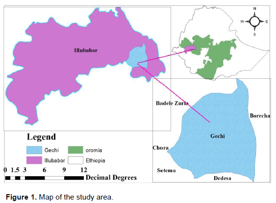
The study was conducted in Gechi District of Ilu Ababora Zone, Oromia National Regional State. The district capital, Gechi is located at a distance of 140 km from Metu Zonal capital and 460 km from Addis Ababa on the main road of Jimma- Badele. The altitude of the Woreda ranges from 1500 to 2297 m.a.s.l. It lies within the tropical climate and extends approximately between: 8 0 8°58’North to 80 24 30’’ North latitude, and 36017°30’ East - 36031°45’ East Longitude. Agro ecology of the district is categorized as dega, woinadega and kola which cover 30.4, 45.7 and 23.9%, respectively (GARDO, 2015) (Figure 1).
An estimated area of the district, based on the former total area of Gechi-Borecha, is about 476 km2. This proportion makes about three percent of the total area of the zone. Gechi is the smallest district of the thirteen districts of Ilu Abba Bora Zone. It shares zonal boundary with Jimma Zone and district boundaries with Beddelle, Borecha and Dedesa districts. It is generally bound by: Jimma Zone - in the Southwest; Dedesa district - in the South; Borecha district - in the West; and Beddelle district - in the North and in the West.
Climate
The district is divided in to three agro-ecological zones: The high-altitude (‘Dega’), mid-altitude (‘Woinadega’), and low-altitude (‘kola’) areas with a proportion of 30.4, 45.7 and 23.9%, respectively. Annual precipitation ranges from 1500 to 2200 mm with 6 to 9 months of rainfall and daily temperature of the district varies from 12 to 35°C. Rainfall variability is an important determinant of the life of rural-farming population of Gechi who practice rain fed agriculture. Generally the district experiences tropical climate as a result of its latitudinal location and its climatic conditions are modified by altitude (GRADO, 2015).
Soil and natural vegetation
According to the information obtained from the Gechi Agricultural and rural development office (GARDO, 2015) the soil distribution of Gechi is dominated by two types of soils: DystricNitosols and vertisols. DystricNitosols cover the southern and western portions of the district while vertisols occupy the eastern and north central parts of the district.
Despite the high deforestation and forest degradation rates over the past two or three decades, the district was fully endowed with dense, broad-leaved forests in the past. This could be deduced from the current presence of remnant indicators of tree species like Aningeria, Podocarpus and so on that are observed standing in the river valleys, farmers’ plots etc. The deforestation and de-vegetation processes that are carried out over time seriously resulted in reducing the biomass cover and the rich biodiversity of the district.
The current combination of natural vegetation of the district includes all types ranging from high dense forests to shrubs and bushes. The species diversity include-Aningeria spp., Podocarpus spp., Cordia africana, Albizia species, Croton macrostachyus, Acacia spp. and Savanna grasses etc.
Selection of the study area and sample size determination
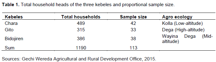
Stratified random sampling technique was used in order to select sample kebeles. There are about 26 kebeles in the district. These kebeles were stratified in to three groups on the base of agro-ecological zones. Out of the three strata three kebeles were selected by purposive sampling methods to show representativeness of the agro ecology of the district, that is, BidoJiren from Woinadega, Gito from Dega and Chara from Kola Kebeles.
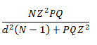
The number of sample households selected for the questionnaire was determined using the formula developed by Cochran (1977):
Where, n = sample size of household. P = 0.1 (proportion of population to be included in sample, that is, 10%). q = is 1-P, that is, (0.9). d = is degree of accuracy desired (0.05). N = total number of housing units. Z = standardized normal variable and its value that corresponds to 95% confidence interval equals 1.96. According to data obtained from districts agricultural and rural development office (2015), there are about 13038 household units (N); out of this 1403 households (P) are district inhabitants/who use electric energy either for cooking or for lightening. This is because majority of the district inhabitants use fuel wood for cooking and baking of’ ‘injera’ and bread even where electric energy source is accessible. Hence:
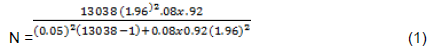
Where n = 113. These (42, 33 and 38 from Chara in Kola, Gito in Dega and BidoJiren in Weyna-Dega agro ecologies respectively) were selected through systematic sampling technique by using the name list of households prepared by kebeles for different purpose, that is, every Nth members were selected from the name lists of the household until the assigned proportion to each kebele was obtained. Therefore, the sample frame of the study is household heads in three sampled kebeles by proportional sampling presented in Table 1. When collecting data, female households were encouraged to participate more because they are expected to know more about the fuel wood but in their absence during interview male households participated.
The forest inventory plots were established both in one site of communal forest of free open access and two sites of state forest accesses only for fire wood collection. A total of six line transects each with an average length of 500 m were laid at a distance of 250 m between transect lines at Chara Forest.
In each plot, transects were determined using a Suunto compass. The first plot was laid at 100 m distance away from the edges to reduce the edge effect for uniformity of sampled plots. On each line transect, five sample plots, measuring 20 m × 20 m (400m2), nested plots of 10 m × 10 m (100 m2), 2 m × 2 m (4 m2), were laid along the transects lines which is approximately at 100 m intervals. Total of 30 plots were sampled in Chara Forest. Within each four sided sample plot, the number of individual seedlings, saplings, and trees of different species was directly counted. In each plot all woody tree species with a diameter at breast height (DBH) > 5.00 cm and height > 3.00 m were considered as trees and they were measured for DBH and height. In the study tree species saplings were considered with a DBH < 5 cm and DBH > 2.00 cm, and 0.50 to 3.00 m height. Similarly seedlings were considered as those stems with DBH < 2.00 cm and height < 0.50 m (Mengistu et al., 2005).
Measurement was conducted to estimate the amount of fire wood consumed by the households. In order to reduce the deformed structures of the fire wood that make it difficult to measure, the bundles collected from the field were cut into smaller piece and laid in straight to avoid gaps between the deformed sticks. The arranged sticks were laid in a width, height and length of 1m × 1m × 1 m to determine compacted volume. Mean volume of bundles consumed were calculated to compare with the volume of standing trees and to determine the annual consumption of fuel wood by community in the area and thereby determine the impact on the forest resource.
Methods of data collection and data sources
The study was undertaken in one site of communal forest area, and in sites of state forest including Oromia wild life and forest enterprise forest to determine the impact of the fuel wood consumption of the forest resources in Gechi district.
The research utilized both quantitative and qualitative methods to gather data from primary and secondary sources. Primary data was collected directly from respondents using questionnaires. In addition direct field observation and measurement of required parameters were used for data gathering. Secondary data was collected through review of related literatures and government sector office reports and documents.
At the beginning of the survey, informal meetings were held with a group of farmers in order to understand the general agricultural development and socio-economic situation of the population of the study area. Informal meetings with key informants (farmers, elder people, women, experts and development agents) were held to gain in-depth knowledge about the area and to pre- test the survey questionnaire. Then after, necessary modifications were made to the questionnaire.
In addition to informal contacts, transect walks across each village were conducted in order to obtain all the necessary physical information and determine the questions that need to be included in the survey. It was a useful technique to characterize and understand biophysical and terrain features such as topography, forest resources, and types of domestic energy use in the local community, land uses, sources of energy for the area.
Data analysis
The methodologies employed to analyze the collected data were descriptive statistics. With regard to data analysis, responses in the questionnaire and interview and vegetation measurements were entered into SPSS software. Percentage and arithmetic mean were also used to condense the data for the purpose of analysis and interpretation. Furthermore, tables and graphs were used to facilitate presentation of results of the analysis and interpretation of data.
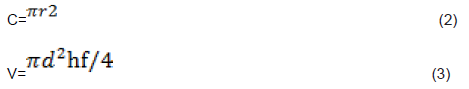
Volume of standing trees was calculated to compare with the volume of the fuel wood consumed by the households. The standing volume was converted into tones by using the density of tree (Maltamo et al., 2004). This was done by establishing an inventory plot by using Smalian formula of tree allometric equation (Loetsch et al., 1973) to identify the number of plots, distances between each plots and area of sample plots units for the plantation forest.
Where, V = Volume of standing tree; d = Diameter of tree; h = height of tree. = 3.142. f = form factor = 0.45; C= circumference of a tree; r=radius. Based on the formula, the standing tree volumes of sampled trees from the state forest from Gito and BidoJirenKebeles of Gechi and natural forest at Chara Kebele were determined.
Socio- economic and demographic characteristics of the respondents
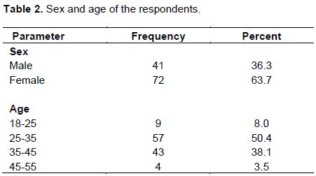
The result of the study showed that 36.3% of the respondents were male while 63.7% were female. About 50.4% of the heads of households were within the age ranges of 25 and 35 years; whereas, about 38.1% belongs to the age group of 35 to 45. Nearly 8% of the respondents were under the age of 25 years and heads of the households over the age of 45 constituted 3.5% of the total. Thus the results of this study revealed that the majority of the respondents are in the economically active age group (Table 2).
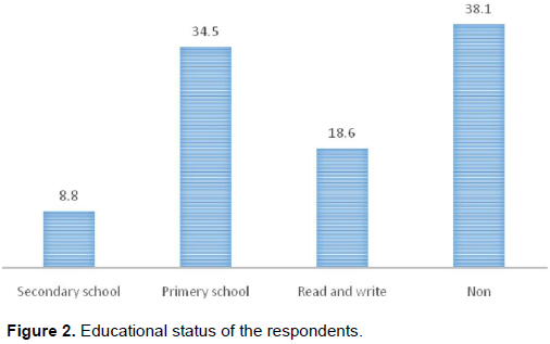
From the total participants of this study, 38.1% of them have had no formal education of any sort while 18.6% of the heads of the households were able to read and write (Figure 2). The remaining 43.5% of the heads of households have attended varying level of educational qualification ranging from elementary school to a high school which is less than the Oromia National Regional State enrolment rate in 2005 which is 61% (MOE, 2005).
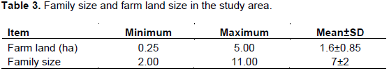
About 92% reported to have fully involved in farming activities as means of supporting their livelihood. The overall average landholding of the respondents in Gechi was reported to be about 1.67 ha/HH as described in Table 5. This is higher than the total land holding /household (1.1±1.26 and 1.4±1.25 ha) in Ada’a and Lume districts of East Shewa, Ethiopia, and also higher than the national average land holding of (1.02 ha) (CSA, 2010).
The mean family size of all the respondents was calculated to be 7.1 persons/hh (Table 3).This result is higher than the mean family size of 6.2 and 6.9 persons/hh recorded from Bure of Amhara regional state and Dale district of SNNP regional states of Ethiopia, both of which are higher than the national average of 5.2 persons/hh (CSA, 2010); the Amhara regional average of 5.4 persons/hh (Halima, 2010) and SNNP regional state average of 5.1 persons/hh (CSA, 2010) were recorded. Regarding their religion, about 97.3% of the respondents were reported to be Muslim and the remaining 2.7% were protestants and orthodox.
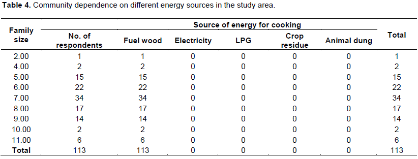
The main energy source for cooking in the community is fuel wood for all households having different family sizes. Although all families depend on fuel wood for cooking, families with larger sizes consume more amount of fuel wood (Table 4)
Sources of energy for cooking and lightening
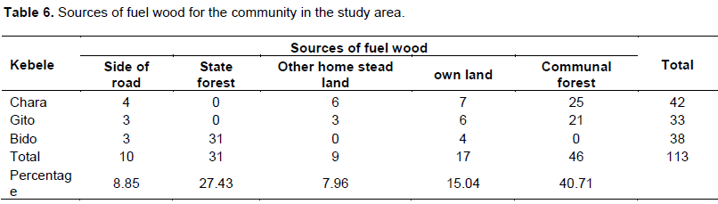
The results of the present study revealed the negative impacts of fuel wood consumption on forest resources, and consequently on biodiversity and human livelihoods in the study area. All of the respondents use fuel wood for cooking and lighting which is higher than the national dependency on the solid energy consumption of the households in Ethiopia which is about 96% in the rural areas (Jargstorf, 2004). About the 85% of farmers in the survey area reported that the distance they have to go for fuel wood collection is increasing through time while only 15% of the respondents indicated that the distance they have to go for fuel wood collection remained the same over time. About 40.71% of the respondents reported that they have been collecting fuel wood from the communal forest and 27.43% had been collecting fuel wood from state forest. This result indicated that the fuel wood collection has been causing degradation of the forest resources on both the state forest and communal forests.
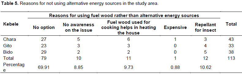
The reasons for using the fuel wood rather than using alternative energy sources as respondent listed included: the lack of access to alternative energy sources; lack of awareness creation on the alternative energy sources; smokes from the fuel wood helps in heating their houses and also as repellant for insects and snakes; and the high cost of alternative energy sources took the lead reason for the community of the area which accounts for 60%. 90% of the community uses the three mold inefficient traditional cooking stoves while only 10% uses the efficient cooking stoves (Table 5). This is one of the major reasons that cause forest degradation in the area. It is also evident that the local people totally depend on construction materials harvested from the natural forest to construct their shelters and also for making different household utensils and farm implements, which also aggravates the problem of deforestation and forest degradation in the area.
Fuel wood sources and their availability
The result showed that 40.71% of the sampled households of the district collect fuel wood from the communal forest while 27.43% collect fuel wood from the state forest (Table 6).
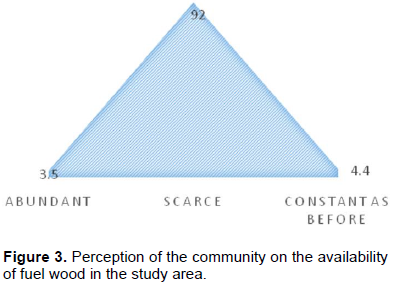
Most respondents (92%) believed that the availability of fuel wood in the forest as well on market has been declining in the area (Figure 3). Only 3.5% of the farmers believed that the availability of fuel wood is abundant. This shows that there is degradation of the forest resources in the study area (Figure 3) leading to fuel wood scarcity through time.
Community’s view on the problem of deforestation
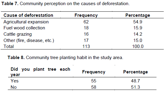
According to the respondents, the distance they have to travel to get fuel wood is increasing through time. This shows that there is still deforestation problem continuing in the area due to fuel wood consumption and other activities (Table 7). The increased distance for collecting fuel wood by the communities has also got negative implication on their livelihood as they have to use more of their time for this purpose, which they would have used for some other productive household activities.
Among the respondents, 54.9% indicated that the agricultural expansion is the major reason for deforestation, while 15.9% believed that fuel wood collection is the second main cause of deforestation in the study area (Table 7). The result is similar with the finding of study conducted at Zuway Dugda Woreda in which 41.2% of the respondents perceived that the lack of more farm land as being the major reason for deforestation (Moges and Reddy, 2013). In the study area, 51.3% of the community do not plant tree each year (Table 8). This implies that community of the study area has been depending on the natural vegetation for fuel wood, fence construction, etc.
Community preference of tree species for fuel wood
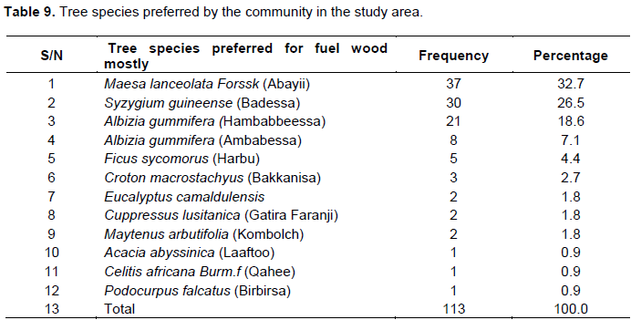
The result showed that the most preferred tree species by the Chara community is Syzygium guineense (locally known as Badessa), while community of Gito and Bido prefer fuel wood sources from Maesa lanceolata, forssk (locally known as Abbayii) (Table 9). This implies that these most preferred species are the most impacted by the fuel wood collection by the community.
As shown in Table 9, M. lanceolata is the most preferred tree species for fuel wood utilization in the study area. The reason for its preference is its availability or abundance and easy access of the species to the community in the study area.
Wood density
Stocking averaged 630 trees per hectare of Cuppressus lusitanica at BidoJiren; 475 stock/hectare Eucalyptus camaldulensis at Gito, 647 trees per hectares of Cuppressus lusitanica at Gito and 1050 different trees/ha at Chara communal forest, with M. lanceolata the dominant species.
Fuel wood consumption of the households
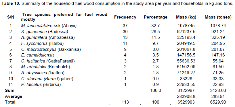
The average amount of fuel wood used by the community in the study area was 6529.9 tons/ha. Similar result was reported by Mariame (1997). The annual fuel wood consumption of the community in the study area is presented in (Table 10).
The study result revealed that three sampled kebele communities consume 6529.90 tons of fuel wood, which is equivalent to 1.76 ha of forest per annum for fuel wood only.
Evans (1992) reported that the mean annual increment of forest in tropics ranges from the 100 to 300m3 per hectare which is equals to 67 to 206 tons/ha. The author also argued that the yield may vary based on the tree species, site quality, spacing, management activities, age, climate etc. The high annual fuel wood consumption in the area of about 6529.9 tons/year implies that the fuel wood collection and consumption is one of the main causes for aggravating deforestation in the study area.
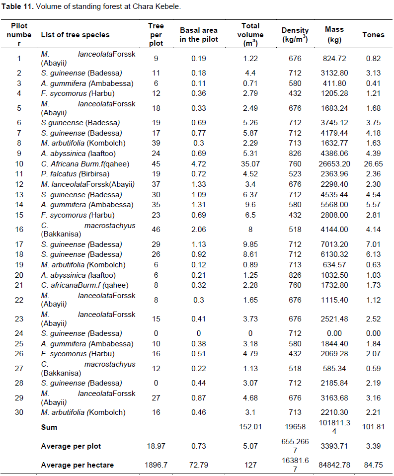
Volume of the chara community forest
The data collected during the vegetation survey revealed that the average volume of the Chara forest is 5.07 m3/0.04 h which is equal to 84.75 tons/ha (Table 11). The total communal forest area at Chara is about 125 ha. Therefore, the total standing forest at Chara is about 10593.75 tons.
In general biomass production in the form of removal of wood for fuel has far-reaching negative outcomes; including soil erosion, reduction in the content of soil moisture and decrease in soil nutrients through leaching; and also for the proper functioning of the ecosystems (Michael et al., 2003). Similarly, as per the findings of the current study, about 100% of households depend on biomass fuel in the form of firewood for their cooking needs, and this definitely is produced by removal of wood cover leading to the same outcomes.
Regeneration of woody species in chara communal forest
From the analysis of seedlings and saplings data, the total population of seedlings, saplings and trees were 2750, 2426 and 1615 ha-1, respectively in the Chara forest (Figure 4). The distribution of seedlings and saplings is greater than mature tree individuals per hectare. This indicates that the regeneration status of the forest is at better status if appropriate sustainable forest management schemes are put in place to allow for the growth of the seedlings and saplings into matured tree population.

The density values of seedlings and saplings are considered regeneration potential of the species. The presence of good regeneration potential shows stability of the species to the environment. Climatic factors and biotic interferences influence the regeneration of different species in vegetation (FAO, 2010). Higher seedling density values get reduced to sapling due to biotic disturbances and competition for space and nutrients. The data analysis revealed that the density values for seedlings and saplings of the population structure of the forest are higher than the matured population. This is an indication that there is a continuous removal of matured trees from the forest resource of the area for different purposes, among which consumption as fuel wood is the major one.
CONCLUSION AND RECOMMENDATIONS
The results of this study revealed that fuel wood consumption has got negative impact on the forest livelihoods in the area. The most preferred tree species resources, consequently on biodiversity and human for the fuel wood are S.guineense (Badessa), M. lanceolata Forssk (Abbayii) and A. gummifera. These three species are mostly extracted from the forest for energy sources for cooking and heating in the study area. Majority of the community have been using biomass energy sources without tree planting activities required for ensuring sustainability of the forest resource. This is, therefore, another factor contributing to deforestation and forest degradation in the area, in addition to the heavy dependence on woody biomass as major energy source. Though fuel wood is a renewable resource, its overuse can lead quickly and easily to shortages, especially in the rural communities unless it is used with required care of balancing its demand with the potential supply. As many households continue to use fuel wood, especially in the rural areas of the country like Gechi, this can negatively impact the economy of the households, through deforestation, and declining agricultural productivity. The implications on the environment are obvious: deforestation, soil erosion, declining agricultural productivity, and destruction of the ecological systems leading to loss of biodiversity and important wildlife. In order to address such undesirable socio-economic and ecological consequences, various interventions such as promotion of improved energy technologies; community awareness creation on consequences of deforestation associated with fuel wood consumption, and on the need to use other alternative modern energy supplies are recommended on the basis of the present study.
The authors have not declared any conflict of interests.
REFERENCES
|
Cochran W (1977). Sampling techniques. 3rd ed. John Wiley and Sons. USA.
|
|
|
|
Damte A, Koch SF, Mekonnen A (2012). Coping with fuel wood scarcity: household responses in rural Ethiopia. Environment for development discussion paper series, EfD DP, 12-01.
|
|
|
|
Dessie G, Kerman J (2007).Pattern and magnitude of deforestation in the South Central Rift Valley Region of Ethiopia. Mountain Res. Dev. 27(2):162-168.
Crossref
|
|
|
|
Ethiopia Central Statistical Authority, CSA (2010). Ethiopia Welfare Monitoring Survey, 2004, Ethiopia Central Statistical Agency, Addis Ababa, Ethiopia.
|
|
|
|
Evans J (1992).Plantation forestry in the tropic .2nd ed. Oxford University press Inc. New York.
|
|
|
|
FAO (Food and Agriculture Organization) (2010). Global forest resources assessment- Forestry Department Food and Agriculture Organization of the United Nations. FRA2010/065 Rome.
|
|
|
|
Gechi Agricultural and Rural Development Office, GARDO (2015). Physical and socio-economic profile of Gechi district assessment result report.
|
|
|
|
Geissler S, Dietmar Hagauer PM, Alexander H, Michael K, Peter S (2013). Biomass Energy Strategy Ethiopia., AMBERO Consulting Gesellschaft mbH Immanuel-Kant-Str. 41, 61476 Kronberg i. Ts.
|
|
|
|
Gurmessa F (2010). Floristic Composition and Structural Analysis of Komto Afromontane Rainforest, East Wollega Zone of Oromia Region, West Ethiopia (Doctoral dissertation, MSc. Thesis, Addis Ababa University, Addis Ababa).
|
|
|
|
Jargstorf B (2004). Renewable energies in Ethiopia. In Symposium on Renewable Energies in Ethiopia (Mobile Exhibition), Addis Ababa (Ethiopia), 26-27 April, 2004. German Technical Cooperation.
|
|
|
|
Loetsch F, Zöhrer F, Haller K (1973). The sample plot. In: Forest inventory. München: BLV Verlagsgesellscchaft. [English translation by K.F. Panzer]. pp. 317-347
|
|
|
|
Maltamo M, Eerikäinen K, Pitkänen J, Hyyppä J, Vehmas M (2004). Estimation of timber volume and stem density based on scanning laser altimetry and expected tree size distribution functions. Remote Sens. Environ. 90(3):319-330.
Crossref
|
|
|
|
Mariame A (1997). "Appraisal of wood fuel supply and demand: A case for Shashemene town, South Ethiopia." Ethiopian MSc in Forestry Programme Thesis Works (Sweden).
|
|
|
|
Mekonnen A, Köhlin G (2009). Determinants of household fuel choice in major cities in Ethiopia.
View
|
|
|
|
Mengistu T, Demel T, Hultén H, Yemshaw Y (2005). The role of communities in closed area management in Ethiopia. Mountain Res. Dev. 25(1):44-50.
Crossref
|
|
|
|
MOE (2005). Educational Statistics Annual Abstract, Addis Ababa: MOE, EMIS. P 5.
|
|
|
|
Moges S, Reddy RU (2013). Farmers Perception on Deforestation in ZiwayDugdaWoreda, Arsi Zone, Ofromia Regional State of Ethiopia. Euro. Acad. Res. 1(9):2686-2701.
|
|
|
|
SEI (2008). Household Energy in Developing Countries: A Burning Issue. Policy Brief. SEI Stockholm, Sweden.
|