ABSTRACT
Bamboo resource assessment has witnessed great interest in the world with very little attention in the Congo Basin forests. This study was initiated to assess bamboo species distribution in Cameroon with respect to Agroecological Zones (AEZ), using remote sensing. Forty-eight sheets of Landsat 8/Operational Land Imager (OLI) and the Thermal Infrared Sensor (TIRS) instruments’ images were mosaiced with the Envi 5.3 software. The bamboo index (BI) was calculated and used to identify wild bamboo-growing regions in Cameroon. Maps of bamboo growing regions helped in ground truthing. GPS coordinates were used to validate the bamboo presence with an accuracy of 78%. The result showed that bamboo spatial area statistics was 794.60, 451 308.36, 241 295.87, 302 989.41 and 219 094.67 ha in Sudano-Sahel, Guinea Savannah, Western Highlands, Monomodal rainfall forests and Bimodal rainfall forest, respectively with a total of 1 215 482.91 ha. Bambusa vulgaris Schrad. ex J.C.Wendl.; Oxytenanthera abyssinica (A. Rich.) Munro; Phyllostachys sp.; Yushania alpina K. Schum; Ochlandra travancorica (Bedd.) Gamble; Dendrocalamus strictus (Roxb.) Nees; Phylostachys atrovaginata C. S. Chao & H.Y.Chou; Phyllostachys aurea Rivière & C. Rivière, were found in Cameroon. O. abyssinica was dominant in Agroecological zones 1 and 2; P. aurea in Agroecological zones 3; and B. vulgaris in respectively Agroecological zones 4 and 5. These results can orientate policies and planning towards a sustainable bamboo sector development and mitigating the effects of climate change in Cameroon.
Key words: Spatial distribution, remote sensing, agroecological zone, climate change mitigation.
Bamboo belongs to the true grass family Poaceae and subfamily of Bambusoideae. There are 128 genera and 1718 bamboo species naturally distributed in tropical and subtropical belts of Africa, Asia, Central and South America (Maria et al., 2016; Canavan et al., 2017). It is one of the fastest growing plants in the world (Kaushal et al., 2018) and, some species can also successfully grow in the temperate regions of Europe and North America (Durai and Trinh, 2019; Nfornkah et al., 2020). The knowledge of bamboo distribution has been greatly enhanced by space technology. The use of remote sensing in mapping and monitoring of the spatial extent of bamboos growing in different regions of the world is a high-priority requirement for planners and resources managers. The conventional method of surveying and estimating the growing stock is time-consuming and costly. However, the development in space technology, particularly the repetitive satellite remote sensing (RS) across various spatial and temporal scales, offers the most economic means of assessing, planning, managing and monitoring the forest resources, including bamboo (Goswami et al., 2010; Zhao et al., 2018).
Bamboo is difficult to identify using remote sensing when compared to other land cover classes. This is due to the fact that: (1) many bamboos are distributed in patches influenced by their local climate conditions or anthropic interventions; thus, requiring high resolution imagery to identify them (Ghosh and Joshi, 2014); (2) some bamboo forms the understory layer of forested zones or mixed with other canopy (Reid et al., 2004; Doležal et al., 2009); (3) bamboo are among the fastest growing plants on Earth and frequently changing, thus increasing the challenge in collecting samples (Mertens et al., 2008; McMichael et al., 2013) and (4) bamboo has similar spectral properties with other vegetation classes, thus limiting the accuracy of spectrum use in separating bamboo from other vegetation types (Singh, 1987; de Carvalho et al., 2013).
Studies have been able to differentiate bamboo from other land use classes with data from remote sensing. Han et al. (2014) use SPOT-5 image data for bamboo mapping. A high spatial resolution, an object-based image analysis method and texture measures obtained from grey level co-occurrence matrices was used to map Moso bamboos in China. Ghosh and Joshi (2014) use the World View 2 imagery, which provide 2 m multi-spectral and 0.5 m panchromatic spatial resolution in lower Gangetic plains in West Bengal, India. The images used were obtained at the beginning of monsoons season, void of clouds. Li et al. (2016) use 4 Landsat images, and prove the importance of temporal information in bamboo mapping in China. Zhao et al. (2018) use multi-temporal Landsat imagery at 30 m spatial resolution, to identify bamboo hotspots of highland (Yushania alpina) and lowland (Oxytenanthera abyssinica) bamboos in Ethiopia, Kenya and Uganda. Du et al. (2018) use multisource remote sensing data to map the global bamboo forest distribution and gave an appropriate area of bamboo forests globally at national or regional scale. INBAR (2018) use the United State Survey Landsat 8 Surface Reflectance images in the based-regional bamboo resource assessment of Madagascar’s bamboo.
Bamboo has vigorous growth, with completion of the growth cycle between 120 and 150 days. This makes bamboo a powerful carbon sink as its sequestration carbon. Yuen et al. (2017) report that, bamboo biomass from 70 species (22 genera) estimated gave plausible ranges for above-ground carbon (AGC) biomass (16-128 Mg C/ha), below- round carbon (BGC) biomass (8- 64 Mg C/ha), soil organic carbon (SOC; 70-200 Mg C/ha), and total ecosystem carbon (94-392 Mg C/ha). They further illustrate that, the total ecosystem carbon range is below that for most types of forests such as the rubber plantations and tree orchards, but greater than agroforests, oil palm, various types of swidden fallows, grasslands, shrublands, and pastures. In a similar dynamic, Nath et al. (2015) find that the mean carbon storage and sequestration rate in woody bamboos range from 30–121 Mg ha−1 and 6-13 Mg ha−1 yr−1 respectively. With this great ability, bamboo can best be positioned in mitigating the effects of climate change within the context of REDD+ (Terefe et al., 2019).
In the context of this study, Landsat 8/OLI-TIRS (Operational Land Imager (OLI) and the Thermal Infrared Sensor (TIRS) instruments) was used for mapping bamboo species distribution in Cameroon. The method of Goswami et al. (2010) was exploited because (1) it covers large surfaces beyond regional level (47 565 000 ha for Cameroon) (Talukdar, 2001), (2) did without temporal data (Ghosh and Joshi 2014) and (3) was less time consuming and cost effective.
Remote sensing shows China’s bamboo resources covering about 6.5 million hectares of forests comprising 40 genera and 800 species (INBAR, 2019a). In East African countries, similar studies estimated bamboo resources in: Ethiopia as: 1 438 705 ha of highland and lowland bamboo resources; Kenya: 131 040 ha of bamboo; and Uganda: 54 587 ha (Zhao et al., 2018). Tanzania has about 127 000 ha of bamboo (Xiaoli, 2006); and Madagascar with about 1 123 694 ha of bamboo resources (INBAR, 2018). This knowledge on the bamboo stocks facilitate and support government actions on their environmental and socio-economic development orientations. In the Central African sub region (Central African forest Commission (COMIFAC)) countries amongst which Cameroon is a member, bamboo stocks are undetermined. A survey in literature for spatial or remote sense-based bamboo resources assessment yields no results; therefore, leaving a wide knowledge gap in the Congo Basin. This study has as objectives to map and identify bamboo species distribution in Cameroon with respect to the different AEZs. These results will facilitate policy and planning orientation towards a sustainable bamboo sector development and fight against effects of climate change in Cameroon in particular and Congo Basin as a whole.
Study area
Cameroon is located between Latitude 2° N to 13° N and Longitude 8° 25’ E and 16° 20’ E in the Central African sub region. It opens to the Atlantic Ocean in the West with a total coastline of 402 km. It is bounded to the west by Nigeria, North-east by Chad, South by Gabon, Congo and Equatorial Guinea and to the East by Central African Republic. It has a total surface area of 47 565 000 ha (MINFOF, 2018).
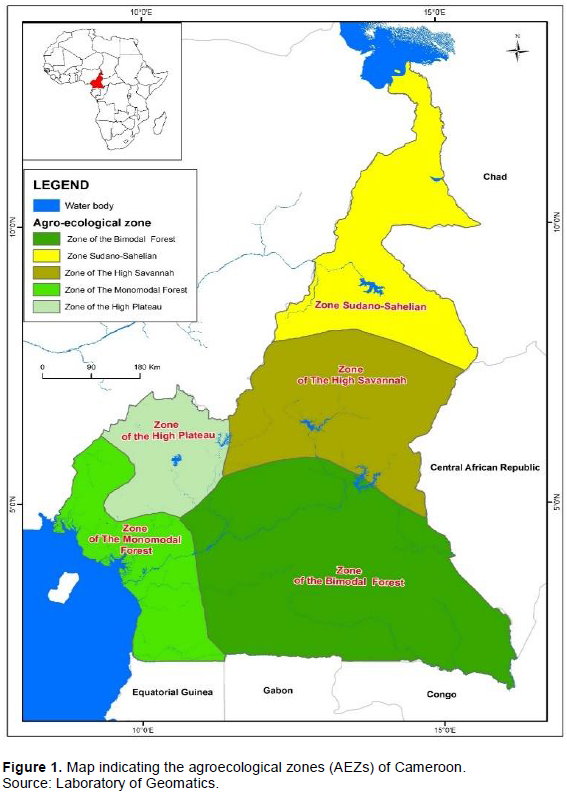
The country is highly ecologically diverse and the diversity has earned Cameroon the title of “Africa in miniature”. MINEPAT (2015) has broadly divided the country into five agroecological zones (Figure 1): agroecological Zone 1 (AEZ 1): Sudano-Sahel (19.8% of the country) where a more or less arid climate prevails; AEZ 2: The high Guinean savannah (19.8% of the country); AEZ 3: Western highlands (8.2%); AEZ4: Monomodal rainfall forest (12.3%) consisting of dense forests with a humid equatorial climate, covering the South West (4.3%), the Coast (3.4%), part of the South (3.7%) and a tiny portion of the Centre (0.7%); and AEZ5: Bimodal rainfall forest (39.9% of the country), composed of humid tropical forests, with a particularly dense hydrographic network, extending over the East (20.7%), the Centre (12.3%) and the South (6.4%). The climate and relief of the different agroecological zones of Cameroon vary between the Agroecological Zones (rainfall: 500-11000 mm; temperature: 21-28°C, elevation: 0.2-4050m) (Toukam et al., 2009). Three major soil types are common across Cameroon; ferralitic soil covering Southern Regions (67%), volcanic soil covering Western Regions and ferruginous soils covering the Northern Regions (Yerima, 2005; Jiotsa et al., 2015; CIRAD, 2020). Vegetation of Cameroon is characterized by both forest and grassland. The forest covers AEZ 4 and AEZ 5 (Letouzey 1985). These zones are covered mainly with the equatorial forest, with the presence of mangroves mainly along the coast of Cameroon. The grassland covers the AEZ 3, 2 and 1 (Dobgima, 2014).
Bamboo is part of the true grass family (Poacea), and makes up the largest and most productive member of the grass family. Bamboos are fast growing plants. They have three growing habits: cluster or clumping or Sympodia; running or spreading or Monopodia and a mixture of clumping and running called Amphipodia (Nath et al., 2015; Terefe et al., 2019). Basically, running bamboos are invasive and spread rapidly, while clumping bamboos generally stay confined to a single area. Bamboo has the ability to grow in regions that range from the sub-Sarahan deserts of Africa, to the cold mountain terrain of the Himalayas. The sizes of bamboo species vary greatly. The smallest varieties grow to a height of 11 inches, while giant timber bamboo can reach heights of over 100 feet (http://www.completebamboo.com/bamboo).
This study was carried out between September and November, 2019. Data was collected in different phases: literature reviewed to gather secondary data and suitable remote sensing method to realise this study. Best imageries were selected, acquired, treated to obtain the bamboo index, and initial bamboo maps. Ground truthing was done with the help of a pocket GPS. Bamboo coordinates were superimposed to validate the final bamboo distributions in Cameroon. Figure 2 summarises the image acquisition, treatment and validation for bamboo distribution in Cameroon. Landsat 8 is the most recently launched Landsat satellite in 2013 and carries the Operational Land Imager (OLI) and the Thermal Infrared Sensor (TIRS) instruments. Landsat 8/OLI-TIRS satellite images were chosen for this study. These images were those of November and December 2018 with a resolution of 30 m. These images were downloaded free of charge from www.glovis.usgs.gov in GEOTIFF format. Zhao et al. (2018) evaluated the accuracies for bamboo mapped using single season imagery and found that the images acquired in September to February are the most informative in identifying bamboos. Images acquired within this interval are less cloudy and shadow less, and they cover the dying back process of vegetation, which is really important for differentiating vegetation classes, especially in identifying lowland bamboos. For reasons of complete coverage of the national territory, 48 sheets of these Landsat 8 OLI-TIRS satellite images were downloaded. Layer stacking consisted of unzipping the tapes and assembling them into a multispectral file. Geo-referencing and radiometric correction allows reposition of the 1m pixel offsets, to make radiometric and geometric corrections (cloud, atmospheric particles etc.). Mosaicking allows for 48 image scenes to be put together, using the Envi 5.3 software in order to have a continuous landscape of the study area.
For index calculations, plant reflectance spectrum is determined by its leaf characteristics. This is controlled by certain factors and the main ones are the photosynthetic pigments and water absorptions. Different mathematical combinations (indices) of the multi-spectral bands are found to be sensitive indicators of the present conditions of specific types of green vegetation (Goswami et al, 2010). In this study context, one index (Bamboo Index) was developed and used to identify wild bamboo-growing areas in Cameroon. Preliminary maps of the bamboo growing regions were printed prior to field survey (ground truthing). Ground truthing was carried out with the help of these maps and local assistance. Bamboo growing areas were located based on the preliminary maps prepared through remote sensing prior to field survey. Resource persons contacted in the various localities gave information and led the different teams to the presence of bamboo in the area. The pocket GPS was used to track and record way points on data sheets. The different steps in ground truthing were: arrives in a target locality, acquires administrative and traditional authorisation; recruit local assistance; and identify bamboo sites. Bamboo specimen vouchers were collected for identity confirmation at the National Herbarium of Cameroon. Figure 3 shows the map of ground truthing in the national territory.
Final validation
The validation consisted in making a comparison between the GPS field coordinates and the calculated bamboo indices. Knowledge-based bamboo species distribution groves in literature aided to upgrade or complement bamboo species identified and their distribution in this study in Cameroon.
Data analysis
Landsat 8 OLI-TIRS imageries were acquired and treated with Envi 5.3 software; and QGIS 3.2. software was used to dress the maps. GPS coordinates from ground truthing permitted to control the bamboo distributions and validation in the various agroecological zones. The following stages were executed: Bamboo indices were developed for the whole country to identify wild bamboo-growing areas of the 5 different AEZs in Cameroon. For example, Figure 4 represents the wild-growing bamboo area in AEZs 1 (Sudano- Sahelian).
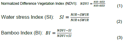
Bamboo-growing areas (magenta) were spectrally differentiated using a combination of red, near Infrared (NIR) and green (Short Wave Infrared (SWIR)) bands: band 2 - blue (0.45-0.51 μm ); band 3 - green (0.53-0.59 μm ); band 4 - Red (0.64 - 0.67 µm) 30 m; band 5 - Near-Infrared (0.85 - 0.88 µm) 30 m; band 6 - SWIR 1(1.57 - 1.65 µm; band 7 - SWIR 2 (2.11 - 2.29 µm) 30 m; and band 8 - Panchromatic (0.50-0.68 μm)) 30 m, for Operational Land Imager (OLI). For Thermal Infrared Sensor (TIRS),the two spectral bands were band 10 TIRS 1 (10.6 - 11.19 µm) 100 m and band 11 TIRS 2 (11.5 - 12.51 µm) 100 m (https://www.usgs.gov/land-resources/nli/landsat/landsat-8). An improved technique is adopted using a measure of Standardised Vegetation Index (NDVI) and water stress index (SI) as a measure of leaf water content (Goswami et al., 2010). Jensen (1996) and Lillesand and Kiefer (2000) define these indices as:
Where: NIR is near infrared; RED is red and SWRI is green.
The demarcation of bamboo areas using water stress index (SI) was possible because of the leaf water content of plants. Leaf water content of bamboo is less than that of other plant species. The index value difference of bamboo leaves with other land-use classes is less. To increase this difference, a normalized (double) difference bamboo index (BI) was prepared using NDVI and SI in a bamboo vegetation. The resultant imagery was then used to identify bamboo areas based on the index values. Accuracy evaluation was done with the help of GPS coordinates collected from ground truthing.
Bamboo spatial area statistics
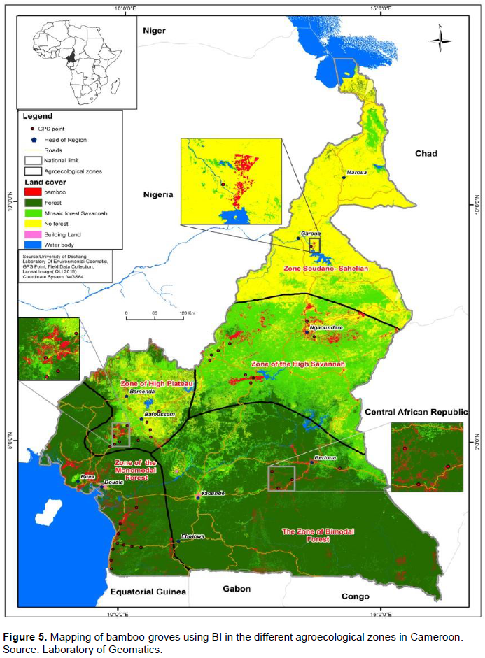
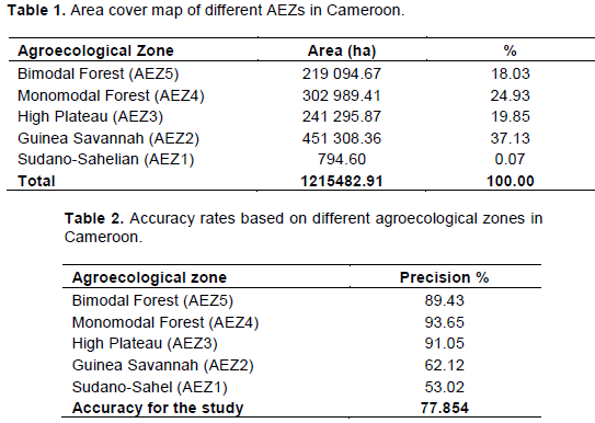
The estimated total area of bamboo distribution in Cameroon for this study was 1,215,482.91 ha (Figure 5). There is unequal distribution of bamboo in the different AEZs (Table 1). Cartographic distribution of the bamboo groves in the different AEZs is illustrated on the map (Figure 5).
Distribution of bamboo groves in the different AEZs in Cameroon
Sudano-Sahelian or AEZ 1
The distribution of bamboos in the AEZ 1 was the least amongst the 5 AEZs with an estimated area of 794.60 ha representing 0.1% of bamboo in Cameroon. Bamboo here is mostly planted at the banks of River Benue; and the species found were both Bambusa vulgaris and Oxytenanthera abyssinica. These bamboos are planted in the Sub Divisions of Lagdo, Garoua 2, Garoua 3 and Pitoa in the North Region. Bamboo indices indicated the presence of bamboo in the North Eastern part of the
Waza National Park along River logon (in the Logon and Chari Division); and in Kaele (Mayo Kani Division) from the Far North Region of Cameroon (not ground truth during survey).
High guinea savannah or AEZ 2
The bamboo index indicated the largest bamboo distribution in the AEZ 2 with (451,308.36 ha) representing 37% of the total bamboo in Cameroon. The dominant bamboo species O. abyssinica was recorded in this zone. O. abyssinica is drought-resistant, so it occurs on the vast savannah woodlands, along the river valleys and spreads around the North Western and North Eastern parts of the Adamaoua plateau. The O. abyssinica was also widely distributed in the South Western part of the AEZ 2, especially on the Beyala hill, Ngaoundal, Tibati, Banyo and Bankim (Njoum-njoh). They strive well in mean rainfall of 1200 mm, mean annual temperature of 23°C and altitudinal range of 500 -1500 (m.a.s.l.). Two bamboo species were conspicuous in this zone: B. vulgaris and O. abyssinica.
Western highlands or AEZ 3
This AEZ 3 has bamboo covering 241,295.87 ha representing 20% of the total bamboo in Cameroon. The bamboo species conspicuously found here were: Phyllostachys sp., B. vulgaris, Ochlandra travancorica (Bedd.) Gamble, and Phyllostachys aurea. Ochlandra travancorica (Bedd.) Gamble was found in life fence/hedge or garden. Phyllostachys aurea was the dominant bamboo specie in AEZ 3 identified in several Divisions like: Noun, Nde; Bamboutos and Haut-Nkam; on the East of western highlands. B. vulgaris groves were also found in abundance in Menoua (Foreke Dschang and Fomopea) Division (South western highland). These were planted on the Foreke escarpment to protect against erosion and landslides. BI indicated the presence of bamboo in Menchum, Bui and Ndonga-Mantong Divisions in the North West Region of Cameroon, part of the AEZ 3 (not ground truth during survey). The climate here had a mean rainfall of 2000 mm; mean annual temperature of 21°C and elevational range of 1500 to 2500 (m.a.s.l.).
Monomodal rainfall forest or AEZ 4
The Monomodal rainfall forest or AEZ (South West, Littoral, part of Centre and South Regions) has a dominant bamboo species B. vulgaris. Bamboo index indicated this AEZ as the second largest in bamboo surface area coverage with an estimated area of 302,989.41 ha representing 25% of bamboo in Cameroon. This study found that on the West and South East of the AEZ 4 road sides, bamboo groves and isolated stands of B. vulgaris were mapped on the Campo – Kribi road; Kribi – Bipindi -Lolodorf- Eseka road; Kribi – Akom 2- Ebolowa road; Akom 2 -Bipindi road; Kribi – Edea road; Edea -Yabassi -Loum road; Edea- Pouma- Boumnebyie road and Loum-Ebonje. B. vulgaris was also found in communities of Mouanko; Mbanga; Djombe; Penja; Manjo; Nkongsamba; and Melong. Other Bamboo species were identified: in Kribi (Dendrocalamus strictus (Roxb.) Nees) and Phyllostachys sp. and Akak- Campo (Ochlandra travancorica (Bedd.) Gamble). BI also largely indicated the presence of bamboo in the coastal areas in the South West Region of Cameroon, which is part of the AEZ 4 (not ground truth during survey). In total, 4 bamboo species were conspicuously found here. AEZ 4 experiences a mean annual rainfall of 3000 mm; mean annual temperature of 26°C and elevational range of -2 to 4000 m.a.s.l.
Bimodal rainfall forest or AEZ 5
The bimodal rainfall forest has a bamboo distribution coverage estimated at 219 094.67 ha representing 18% of the total bamboo in Cameroon. B. vulgaris was the dominant species. B. vulgaris groves were found distributed in areas like Bibey (Mbeli locality); Nanga-Eboko (Mfomalen); Nkoteng (Nzili locality); Ebolowa (localities of Nkoueloun, Niabizam, Akom 2 and Bidou); Eseka (Bat-Bat and Sombadjeck); Mandjou (Kouba and Ngamboula) ; Abong Mbang (field survey); Lomie and; Djembe and Lobeke. The O. travancorica species was identified in Bertoua. In the main towns of AEZ 5, the bamboo species Phyllostachys sp. was largely used in life fencing/ hedges and or garden bamboos. The climate here recorded annual mean rainfall of 1600 mm; mean annual temperature of 25°C and elevation of 400 to 1000 (m.a.s.l.).
Accuracy rate of bamboo images
The accuracy rate of bamboo surveyed in AEZs 1 and 2 were 53 and 62% respectively, while AEZ 4 recorded excellent precision of 94%. Then, the mean accuracy rate was 78% (Table 2).
Bamboo spatial area statistics
Cameroon in the Central African sub Region, through this study will be the first country to have estimates of their bamboo stocks spatially, placing this study as a baseline for the other nations within this block. The results of this study showed Cameroon as the second in terms of surface area covered (1,215,482.91 ha) with bamboos in Africa after Ethiopia with 1,438,705 ha and thirdly by Madagascar with 1 123 694 ha of bamboo resources (INBAR, 2018; Zhao et al., 2018). Ghana has 300 000 ha of bamboo (Kwame et al., 2020). However, in terms of the number of bamboo species, Madagascar is the first with 33 bamboo species (Kigomo, 1988; Gurmessa et al., 2016). China has over 6.5 million ha of bamboo surface cover currently (INBAR, 2019b).
Distribution of bamboo groves in the different AEZs in Cameroon
This result made us to understand that different bamboo species are adapted to different ecological zones and their presence seemly affected by altitudes in Cameroon. The different bamboo species abundance in different AEZs may have altitudinal influence in Cameroon (Paudyal et al., 2019; Deo Kumar et al., 2013; Yuen et al., 2017; Terefe et al., 2019). B. vulgaris species is found in all AEZs probably because of their wide range in altitudes (300-1500 m.a.s.l) that favours its growth and development, and can be naturalised easily (Paudyal et al., 2019; Deo Kumar et al., 2013). O. abyssinica is abundant in the AEZs 1 and 2 probably because it is drought tolerant specie (Inada and Hall, 2008; Deo Kumar et al., 2013, Yohannes, 2019) and lowland specie (Yohannes, 2019), which is synonymous to the climate and altitude of the AEZ 1 and 2. Phyllostachys sp. strives best at altitudinal range of 1200-1400 m.a.s.l which fits exactly with the altitude of the zone of dominance in AEZ 3 and Yushiana alpina are more adapted to hilly or a certain level of attitude above 2200 m.a.s.l. and the Kilum-Ijem Mt. is above 3000 m.a.s.l. (Grimshaw, 1999; Ingram et al., 2010; Deo Kumar et al. 2013).
This distribution is very crucial and is targeted for Cameroon. The Government of Cameroon (GoC) and INBAR are developing bamboo policy and complementary legislations for a sustainable development of the bamboo sector (Neba et al., 2020). This study will inform policy makers (GoC), planners (INBAR) and development partners on the number of hectares of bamboo existing already in Cameroon, their distributions and the dominant species. This could orientate bamboo development policies, strategies (under elaboration) and bamboo plan (MINFOF, 2018; Muh et al., 2018), in the respective ecological zones with respect to more adapted bamboo species. For example, the present known bamboo stocks could be expanded by planting bamboo in marginal and degraded lands of the Guinea savannah and Sudano- Sahelian zones (AEZ 1 and 2) to mitigating the effects of climate change (FAO and INBAR, 2018; INBAR, 2019a); mangroves of the Coastal or Littorals (AEZ 4) of Cameroon, especially aquatic biodiversity conservation (Wetlands International, 2008), bioenergy feedstocks: biofuel, fodder for cattle in AEZs 1, 2 and 3 (Nellie et al., 2012; UNEP, 2019); agricultural production (bamboo agroforestry) (MINADER 2015), industrial transformation of bamboo into best utilities: paper pulp, furniture, construction etc. (AEZ 3, 4 and 5) (INBAR, 2019b). Local population benefits the exploitation of the bamboo rudimentarily and use for social needs in Cameroon (Ingram et al., 2010). This result supports the reference of Goyal et al. (2012) that bamboo is a ‘poor man’s timber’ and is used by many rural populations in daily life.
The images showed the presence of bamboo in part of AEZ1 (Far North); AEZ 3 (North West), and AEZ 4 (South West) regions; that ground truthing did not take place due to insecurity. Complementary data was collected from literature to describe bamboo distribution in the North West region (NW), part of AEZ 3. In Bui (Mt. Kilum Ijum of Oku); Y. alpina is the dominant bamboo species at an altitude above 2000 m (Ingram et al. 2010). B. vulgaris has also naturalised in the NW. B. vulgaris as reported in Bamenda, Bali Nyonga, Bafut, Wum, with their main harvesting sites being Bafut, Bambui and Bamenda (Lauber, 1990; Maisels and Forboseh, 1999; Cheek et al., 2000; Ingram et al., 2010).
In the South West Region, part of AEZ 4, Ingram et al. (2010) report B. vulgaris as the dominant species in the Man O war, Lissoka, Idenao, Mundemba and Korup etc. The presence of bamboo groves and isolated stands are reported on Ekok-Mamfe road; Mamfe – Otu road; Buea, Muea, Molyko, Bokwango, Bonananjo, Bonakanda and Bokwai; Bimbia, Tiko, Mutengene, Limbe and Idenau; Kumba, Takamanda, Mamfe (Dione et al., 2000; Ingram et al. 2010). Mt Kupe; Bimbia Bonadikombo, Manyu and Meme Divisions extensively along the Kumba-Mamfe stretch, in Buea, Limbe, Lebialem and Mundemba; Bachuo’ntai and Eyumojock-Manyu Division, Buea, Limbe; Ejagham, Ossing, Kembong, Besong-Abang (Cheek et al., 2004; Mdaihli et al., 2002; Tabot, 2006; Nkwatoh, 2005).
Accuracy rate of bamboo images
A number of studies (Singh, 1987; de Carvalho et al., 2013; Zhao et al., 2018) have reported that some bamboo species (O. abyssinica) has affinity to shrublands and grasslands. This creates confusion in differentiating bamboo from the shrublands and grasslands leading to overestimation of bamboo in such zones. This should likely be the reasons behind the low accuracy rate in AEZ 2 and AEZ 1. The precision was low confirming the phenological confusion between the bamboo and shrubs/grasses. Bamboo is probably over estimated in these zones. Another reason would be that during the dry season, this specie, O. abyssinica, lose their leaves by shedding. O. abyssinica losing their leaves during this period may negatively affect bamboo index power from discriminating and differentiating different plant leaves from those of bamboo, thus increasing BI error margin. This rate of confusion can be overcome with thorough ground trothing, repeated temporal and spatial treatment of images and validations of the bamboo images. On the other hand, there is a high tendency that bamboo is underestimated in AEZs 4 and 5. This is because of the canopy shade in the tropical rainforest area (Reid et al., 2004; Doležal et al., 2009), and more so, the phenological confusion of Y. alpina and B. vulgaris to forest tree canopy (Zhao et al., 2018). The accuracies in AEZs 3, 4 and 5 were high and may be due to the fact that B. vulgaris, Phyllostachys sp. and Y. alpina do not shade leaves in the dry season thus, their leaves were clearly discriminated from other foliage type by index treatment (BI). Knowledge-based results of other bamboo studies would be of help for studies beyond national or regional level.
Spatial distribution mapping of bamboo is necessary for resource evaluation, conservation of biodiversity, and ecological management. This study estimated the total bamboo surface area cover in Cameroon as 794.60, 451 308.36, 241 295.87, 302 989.41 and 219 094.67 ha in Sudano-Sahel, High Guinea Savannah, Western Highlands, Monomodal rainfall forests and Bimodal rainfall forest respectively; giving a total of 1 215 482.91 ha. From knowledge-based identification of bamboo species per AEZ, O. abyssinica dominated the bamboo species in the AEZ 1 and 2; P. aurea dominated AEZ 3; B. vulgaris dominated AEZ 4 and 5. The different bamboo species identified during this study included B. vulgaris, O. abyssinica, Phyllostachys sp., Y. alpina, O. travancorica, D. strictus, P. atrovaginata, and P. aurea. This baseline study in the Congo Basin can be exploited by other researchers and policy makers to orientate policies towards the development of bamboo resources in the Cameroon and Congo Basin.
The authors have not declared any conflict of interests.
The authors are grateful to the International Bamboo and Rattan Organisation for financing the field survey. They also appreciate all field and laboratory assistants who ensured the success of this study.
REFERENCES
|
Canavan S, Richardson DM, Visser V, Le Roux JJ, Vorontsova MS, Wilson JRU (2017). The global distribution of bamboos: assessing correlates of introduction and invasion. Annals of Botany Plants 9(1):plw078.
Crossref
|
|
|
|
Cheek M, Onana J, Pollard B (2000). The plants of Mount Oku and the Ijim Ridge, Cameroon: a conservation checklist. Royal Botanic Gardens, Kew, UK.
|
|
|
|
|
Cheek M, Pollard BJ, Darbyshire I, Onana J-M, Wild C (2004). The plants of Kupe, Mwanenguba and the Bakossi Mts, Cameroon a conservation checklist. Royal Botanic Gardens, Kew, UK.
|
|
|
|
|
CIRAD (2000). Variations in Soil Fertility Under Cotton Crops in The Bénoué Cotton-Growing Area in Northern Cameroon. Beltwide Cotton Conferences, Nashville, Tennessee. Pp 1635-1641.
|
|
|
|
|
de Carvalho AL, Nelson BW, Bianchini MC, Plagnol D, Kuplich TM, Daly DC (2013). Bamboo-Dominated Forests of the Southwest Amazon: Detection, Spatial Extent, Life Cycle Length and Flowering Waves. PLoSONE 8:1 .
Crossref
|
|
|
|
|
Deo Kumar T, Dinesh D, Sambhawana G, Sharma NP, Shrestha DG (2013). Bamboo Diversity, Distribution Pattern and its uses in Sikkim (India) Himalaya. International Journal of Scientific and Research Publications 3(2): 2250-3153.
|
|
|
|
|
Dione AM, Tamnjong I, Ndam N, Blackamore P (2000). Socio-economic case study of the production consumption system of the rattan sector in Cameroon. International Network for Bamboo and Rattan.
View
|
|
|
|
|
Dobgima AN (2014). A thematic study and the New syllabus specifications Approach. 324 p.
|
|
|
|
|
Doležal J, Matsuki S, Hara T (2009). Effects of dwarf-bamboo understory on tree seedling emergence and survival in a mixed-oak forest in northern Japan: a multi-site experimental study. Community Ecology 10(2):225-235.
Crossref
|
|
|
|
|
Du H, Mao F, Li X, Zhou G, Xu X, Han N, Zhu D (2018). Mapping global bamboo forest distribution using multisource remote sensing data. Journal of Selected Topics in Applied Earth Observations and Remote Sensing 11(5):1458-1471.
Crossref
|
|
|
|
|
Durai J, Trinh TL (2019). Manual for Sustainable Management of Clumping Bamboo Forest. International Bamboo and Rattan Organisation (INBAR). www.inbar.int.
|
|
|
|
|
FAO, INBAR (2018). Bamboo for land restoration. INBAR Policy Synthesis Report 4. Beijing, China: INBAR.
|
|
|
|
|
Ghosh A, Joshi P (2014). A comparison of selected classification algorithms for mapping bamboo patches in lower Gangetic plains using very high-resolution worldview 2 imagery. International Journal of Applied Earth Observation and Geoinformation 26:298-311.
Crossref
|
|
|
|
|
Goswami J, Tajo L, Sarma KK (2010). Bamboo resources mapping using satellite technology. Current Science 99(5):650-653.
|
|
|
|
|
Grimshaw JM (1999). The Afromontane Bamboo, Yushania alpina, On Kilimanjaro. Journal of East African Natural History 88(1):79-83.
Crossref
|
|
|
|
|
Gurmessa F, Gemechu T, Soromessa T, Kelbessa E. (2016). Allometric Equations to Estimate the Biomass of Oxytenanthera abyssinica (A. Rich.) Munro. (Ethiopian Lowland Bamboo) in Dicho Forest, Oromia Region, Western Ethiopia. International Journal of Research Studies in Biosciences 4(12):33-48.
Crossref
|
|
|
|
|
Goyal AK, Ghosh PK, Dubey AK, Sen A (2012) 'Inventorying bamboo biodiversity of North Bengal: acase study'. International Journal of Fundamental and Applied Sciences 1(1):5-8.
|
|
|
|
|
Han N, Du H, Zhou G, Sun X, Ge H, Xu X (2014). Object-based classification using SPOT-5 imagery for Moso bamboo forest mapping. International journal of remote sensing 35(3):1126-1142.
Crossref
|
|
|
|
|
Inada T, Hall JB (2008). Oxytenanthera abyssinica (A.Rich.) Munro. In: Louppe, D., Oteng-Amoako, A.A. & Brink, M. (Editors). PROTA (Plant Resources of Tropical Africa / Ressourcesvégétales de l'Afriquetropicale), Wageningen, Netherlands. Available online at:
View (Accessed 31st December, 2019).
|
|
|
|
|
International Bamboo and Rattan Organisation (INBAR) (2018). Remote Sensing-Based Regional Bamboo Resource Assessment Report of Madagascar; Tsinghua University of China. Beijing: INBAR.
|
|
|
|
|
International Bamboo and Rattan Organisation (INBAR) (2019a). Trade Overview 2017: Bamboo and Rattan Commodities in the International Market. International Bamboo and Rattan Organisation, Beijing China 32 p.
|
|
|
|
|
International Bamboo and Rattan Organisation (INBAR) (2019b). Trade Overview 2018 Bamboo and Rattan Commodities in China. International Bamboo and Rattan Organisation, Beijing China 15 p.
|
|
|
|
|
Ingram V, Tieguhong JC, Nkamgnia EM, Eyebe JP, Ngawe M (2010). The bamboo production to consumption system in Cameroon. Bogor: CIFOR.,x-pp. View
|
|
|
|
|
Jensen JR (1996). Introductory Digital Image Processing. Prentice Hall, New York.
|
|
|
|
|
Jiotsa A, Timothy MO, Yambene H (2015). Cooperative Movements in the Western Highlands of Cameroon, Journal of Alpine Research.
Crossref
|
|
|
|
|
Kaushal R, Kumar A, Jayaraman D, Mandal D, Rao IVR, Dogra P, Alam NM, Gupta A, Tomar JMS, Singh DV, Mehta H, Mishra PK (2018). Research methodologies for field monitoring, analysis and evaluation of resource conservation aspects of bamboos. International Bamboo and Rattan Organisation, Beijing China 9(4):124.
|
|
|
|
|
Kigomo BN (1988). Distribution, cultivation and research status of Bamboo in Eastern Africa.
|
|
|
|
|
Kwame AO, Elizabeth AO, Haruna A, Sarah P (2020). Bamboo policy integration analysis, Ghana. International Bamboo and Rattan Organisation, Beijing China.
|
|
|
|
|
Lauber W (1990). Palaces and compounds in the grasslands of Cameroon: traditional wood architecture of a West African country. Karl Kramer & Co. Verlag, Zurich.
|
|
|
|
|
Letouzey R (1985). Notice de la carte phytogéographique du Cameroun au 1:500000 (Toulouse : Institut de la carte internationale de la végétation).
|
|
|
|
|
Li M, Li C, Jiang H, Fang C, Yang J, Zhu Z, Shi L, Liu S, Gong P (2016). Tracking bamboo dynamics in Zhejiang, China, using time-series of Landsat data from 1990 to 2014. International Journal of Remote Sensing 37(7):1714-1729.
Crossref
|
|
|
|
|
Lillesand TM, Kiefer RW (2000). Remote Sensing and Image Interpretation. John Wiley, New York.
|
|
|
|
|
Maisels F, Forboseh P (1999). Phenology of the major tree and shrub species of the Kilum Ijim forest. Ecological Monitoring Programme.
|
|
|
|
|
K.-I. F. Project. BirdLife International and the Ministry of Environment and Forestry, Cameroon.
|
|
|
|
|
Maria SV, Lynn GC, Dransfield J, Govaerts R, Baker WJ (2016). World Checklist of Bamboo and Rattans. INBAR Technical Report No 37: International Bamboo and Rattan Organisation, Beijing China. 454 p.
|
|
|
|
|
McMichael CH, Bush MB, Silman MR, Piperno DR, Raczka M, Lobato LC, Zimmerman M, Hagen S, Palace M (2013). Historical fire and bamboo dynamics in western Amazonia. Journal of Biogeography 40(2): 299-309.
Crossref
|
|
|
|
|
Mdaihli M, Schmidt-Soltau K, Ayeni JSO (2002). Socioeconomic baseline survey of the villages in and around the Takamanda Forest Reserve. Program on Forests (PROFOR) 54 p.
|
|
|
|
|
Mertens B, Hua L, Belcher B, Ruiz-Pérez M, Maoyi F, Xiaosheng Y (2008). Spatial patterns and processes of bamboo expansion in Southern China. Applied Geography, 28(1) :16-31.
Crossref
|
|
|
|
|
MINADER (2015). The State of Biodiversity for Food and Agriculture in the Republic of Cameroon. Ministry of Agriculture and Rural Development, Cameroon, 197 pp.
|
|
|
|
|
MINEPAT (2015). Elaboration du Plan de Zonage du Territoire National ; Rapport de la phase 1: Situation de l'occupation nationale. Ministry of Economy and Regional Planning, Cameroon.
|
|
|
|
|
MINFOF (2018). Programme National de Développement de la filière du Bambou de Chine au Cameroun. Ministry of Forestry, Wildlife and Fishery, Cameoon.
|
|
|
|
|
Muh E, Amara S, Tabet F (2018). Sustainable energy policies in Cameroon: A holistic overview. Renewable and Sustainable Energy Reviews 82:3420-3429.
Crossref
|
|
|
|
|
Neba BN, Chimi DC, Gadinga W, Kaam R (2020). Bamboo Policy Integration Analysis Cameroon. INBAR working paper, International Bamboo and Rattan Organisation 24 p.
|
|
|
|
|
Nath AJ, Lal R, Das AK (2015). Managing woody bamboos for carbon farming and carbon trading. Global Ecology and Conservation 3:654-663.
Crossref
|
|
|
|
|
Nellie O, Mattia V, Ewan B (2012). Sustainable Feedstock Management for Charcoal Production in Kenya. Working Brief 40 p.
|
|
|
|
|
Nfornkah BN, Rene K, Tchamba M, Zapfack L, Chimi DC, Gadinga WF, Tanougong AD, Tsewoue MR, Atchombou JB, Tientcheu L, Zanguim TGH, KedeY, Djeukam SV (2020). Culm Allometry and Carbon Storage Capacity of Bambusa vulgaris Schrad. ex J.C.WendL. in the Tropical Evergreen Rain Forest of Cameroon, Journal of Sustainable Forestry.
Crossref
|
|
|
|
|
Nkwatoh AF (2005). Production and marketing of non-timber forest products (NTFPs), a major source of rural and national income in the South West Province of Cameroon. 17th Commonwealth Forestry Conference, Colombo, Sri Lanka, 25 February -5 March 2005.
|
|
|
|
|
Paudyal K, Adhikari S, Sharma S, Samsudin YB, Paudyal BR, Bhandari A, Birhane E, Darcha G, Trinh TL and Baral H (2019). Framework for assessing ecosystem services from bamboo forests: Lessons from Asia and Africa. Working Paper 255. Bogor Indonesia: CIFOR.
|
|
|
|
|
Reid S, Díaz IA, Armesto JJ, Willson MF (2004). Importance of native bamboo for understory birds in Chilean temperate forests. The Auk 121(2):515-525.
Crossref
|
|
|
|
|
Singh A (1987). Spectral separability of tropical forest cover classes. International Journal of Remote Sensing 8:971-979.
Crossref
|
|
|
|
|
Tabot TE (2006). Strengthening forward and backward linkages in the Rattan and Bamboo sectors in Africa: the case of South West Region of Cameroon. Paper presented at ITTO/ ICBR / INBAR International Workshop on Sustainable Development of Global Rattan Sector. 1st Bamboo and Rattan Standardization Training Workshop: 23-27 July, Beijing, China.
|
|
|
|
|
Talukdar G (2001). Mapping of open bamboo brakes and forest areas using satellite remote sensing in Meghalaya. North Eastern Space Applications Centre, Umiam.
|
|
|
|
|
Terefe R, Jian L, Kunyong Y (2019). Role of Bamboo Forest for Mitigation and Adaptation to Climate Change Challenges in China. Journal of Scientific Research and Reports 24(1): 1-7.
Crossref
|
|
|
|
|
Toukam MSG, Cellier G, Wicker E, Guilbaud C, Kahane R, Allen C, Prior P (2009). Broad diversity of Ralstonia solanacearum strains in Cameroon. Plant Disease 93:1123-1130.
Crossref
|
|
|
|
|
United Nations Environment Programme (UNEP) (2019). Review of Wood fuel Biomass Production and Utilization in Africa: A Desk Study. United Nations Environment Programme, Nairobi 00100, Kenya.
|
|
|
|
|
Wetlands International (2008). Biofuels in Africa: An assessment of risks and benefits for African wetlands 58 p.
View
|
|
|
|
|
Xiaoli W (2006). Comparative Analysis and Policy Recommendations on Developing Bamboo Resource Tenure Systems in Asia and Africa. Joint Project in Cooperation with INBAR and WFI. International Fellow at World Forest Institute Department of Forest Resources and Management, State Forestry Administration of China. Portland, Oregon USA.
|
|
|
|
|
Yerima BPK, Van Ranst E (2005). Major Soil Classification Systems used in the Tropics: Soils of Cameroon. Trafford Publishing, Canada.
|
|
|
|
|
Yohannes D (2019). Regeneration study of lowland bamboo (Oxytenanthera abyssinica A. R. Munro) in mandura district, Northwest Ethiopia. Biodiversity International Journal 3(1):18-26.
Crossref
|
|
|
|
|
Yuen JQ, Fung T, Ziegler AD (2017). Carbon stocks in bamboo ecosystems worldwide: Estimates and uncertainties. Forest Ecology and Management 393:113-138.
Crossref
|
|
|
|
|
Zhao Y, Feng D, Jayaraman D, Belay D, Sebrala H, Ngugi J, Maina E, Akombo R, Otuoma J, Mutyaba J, Kissa S, Qi S, Assefa F, Oduor NM, Ndawula AK, Li Y, Gong P (2018). Bamboo mapping of Ethiopia, Kenya and Uganda for the year 2016 using multi-temporal Landsat imagery. International Journal of Applied Earth Observation and Geoinformation 66:116-125.
Crossref
|
|