Sokoto State is one of the states in Nigeria that are prone to desertification. This study attempts to identify and delimit areas affected by desertification in the three northernmost Local Government Areas of Sokoto State, namely: Illela, Gada and Tangaza. Field study was carried out to verify the incident and occurrence of desertification and the menace of sand deposition. A simple random sampling method with questionnaire, combined with Focused Group Discussions and Key Informant Interviews was used to derive the local knowledge about sand transport and deposition, and, its socio-environmental impacts. The Digital Elevation Model of Tangaza, Gada, and Illela Local Government Areas for the year 2008 and 2014 were derived from ASTER images. The result indicated that the Gidan Kaura hill grew by about 30 m within the six-year period. This agreed with an overwhelming belief by 95% of the respondents that the area continues to suffer from sandstorms and sand deposition. This was visibly confirmed by the presence of sand dunes in most of the areas visited in the three local government areas. Normalized Difference Vegetation Index derived from Landsat images of the year 2013 and 2018 gave further insight into the current vegetation conditions.
Desertification is a global environmental problem. It is defined as land degradation in arid, semi-arid, and dry sub-humid areas resulting from various factors including climatic variations and human activities (UN, 1992; Olagunju, 2015). Similarly, from the point of view of Jamala et al. (2013), desertification represents any process that intensifies or extends desert conditions, leading to reduction in biological yield, impacting biomass production negatively, resulting in insufficient land area for livestock management and reduced crop production to satisfy human nutritional needs. Some of the climatic variations that have been implicated in drought and desertification include increased sea-surface temperature (Giannini et al., 2003), rainfall shortages or drought (Dai et al., 2004) and sand transportation and deposition (Ikazaki, 2015); while the implicated human activities in desertification include deforestation, over-grazing and unsustainable fuel-wood harvesting that lead to reduced vegetation cover (Tucker et al., 1991).
Desertification was first addressed as a global environmental menace with profound socio-economic and environmental impacts in the United Nations Conference (UNCOD) on Desertification in 1977. The Conference led to the adoption of a Plan of Action to Combat Desertification (PACD), to which Nigeria is a signatory. This early global realization of the environmental menace of desertification and the capability of its transboundary extension necessitated the call by the UN General Assembly in Rio de Janeiro, Brazil in 1992, for an inter-governmental committee to prepare for a legally binding instruction that addresses the problem of desertification (UN, 1992). According to UNCCD (2013), desertification and drought are responsible for rapid increase in price indices of food stuff and other commodities. The impact of desertification on the socio-economic life of rural households leads to reduction in crop and animal production, as well as causing livestock deaths and rise in the prices of foodstuffs. People migrate as a consequence of drought and desertification to urban areas or to other rural areas, in order to engage in economic activities such as farming, grazing and fishing (Olagunju, 2015). Migration impact on family life leads to disruption of family ties. Viewed over a broad spectrum, other identified factors causing desertification include excessive wood extraction (Jamala et al., 2013) for fuel exacerbated by increasing population and urbanization, and over-cultivation of marginal land.
The northernmost States of Nigeria, with an annual mean rainfall of less than 600 mm per year (Folaji, 2007) have been described as susceptible to desertification (Mohammed, 2015). In response to the menace of desertification, one of the Nigerian Government’s efforts in combating desertification was through the Global Tree Planting Project, which started in 2005. The project was aimed at halting desert encroachment in 46 LGAs in the country’s desertification frontline States. A 5 km tree planting in each LGA of Sokoto State was initiated under the oil Subsidy Reinvestment and Empowerment Programme (Sure-P). The Sure-P was a programme of the Federal Government of Nigeria, to ameliorate youth unemployment (Ugwu, 2012). Expectedly, all the efforts were confined to the northernmost part of Nigeria, where the menace is most prevalent (Olagunju, 2015). However, studies (Linacre and Geerts, 2002; Geist and Lambin, 2004) generally attempted to denounce this fact, by describing desertification as a succession of cycles of drought interspersed with high rainfall periods. However, with the rampaging ethno-religious insurgency prevailing in the most part of northern Nigeria, covering of the whole north as would have been expedient in this study became impossible. Consequently, Sokoto State, which is not affected by the Boko Haram insurgency was selected as the study area for the purpose of ease of accessibility to the affected sites and safely carrying out field observations. Therefore, the aim of this study was to carry out assessment of desertification or desert encroachment in northernmost part of Sokoto State of Nigeria.
Studies on the Sahel region of Africa (Eklundh and Sjolstrom, 2003; Aiguo et al., 2004) have focused on using time series medium resolution optical satellite image to track variations in Normalized Difference Vegetation Index (NDVI). The Earth observation satellite images that were used in other studies (Martin and Saha, 2009; Dasgupta et al., 2015) gave insight into environmental conditions of physically inaccessible terrains and large landscape that could not have been done through conventional ground-based survey methods. Given that desertification occurs over a long-term period, the accurate identification of affected areas will necessarily require time-series data rather than single datasets. The specific objectives are to carry out in-situ observations to identify specific areas of occurrence; and examine the local socio-environmental factors that are responsible for its occurrence. This study combined in-situ surveys with the Earth observation approaches adopted in the aforementioned previous studies to attempt to understand the local socio-cultural, economic and environmental impacts of desertification in the study area.
Study area
Sokoto lies on the north-west zone of Nigeria and shares its borders with Niger Republic to the north, Katsina State to the East, Niger State to the South-east, Kwara State to the South and Benin Republic to the west. The zone is found between latitudes 10°N and 13°58’ N; and longitudes 4° 8’E and 60 54’ E. The area so defined covers a land area of approximately 62,000 km2 (Ekpoh and Nsa, 2011). The climate of the zone is controlled largely by the dry, dusty, tropical- continental air mass originating from the Sahara desert, and the warm, tropical-maritime air mass originating from the Atlantic Ocean. The influence of both air masses on the region is determined largely by the movement of the Inter-Tropical Convergence Zone (ITCZ), a zone representing the surface demarcation between the two air masses (Ekpoh and Nsa, 2011). The interplay of these two air masses gives rise to the wet season associated with the tropical maritime air mass, and the dry season, associated with the tropical continental air mass. The temperature ranges between 35 and 40°C, while the warmest months are February, March and April when daytime temperatures can exceed 45°C. The combined effects of temperature, humidity, rainfall, and other climatic variation, determine the different types of vegetation belts in the zones and the types of the indigenous or exotic crops that are and can be grown in Nigeria (Adetiloye et al., 2006).
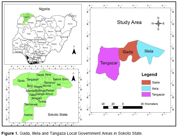
Three northernmost Local Government Areas of Illela, Gada and Tangaza of Sokoto State (Figure 1) were selected to gather information on desertification; and, its impacts on the people and environment. Illela is on Latitude 13°43′ N and Longitude 5°18′ E with an area of 1,246 km²; Gada is located on Latitude 13°46′ N and Longitude 5°40′ E with an area of 1,315 km²; and, Tangaza, is located in Latitude 13° 31′ N and Longitude 4° 58′ E with an area of 2,477 km². Illela, Gada and Tangaza has a population of 248,267, 150,489 and 113,853, respectively
(NPC, 2006) . The study area is characterized by high wind speed with attendant transport and deposition of sand particles. It has few and scattered shrubs, with plantations of Neem (
Azadirachta indica) trees serving as shelter belts, occupying many areas of the landscape. The three Local Government Areas share contiguous borders with the Niger Republic to the north. Across the three Local Government Areas, the field study took place in five areas, located at the Government Day Secondary School and Kalmalo village in Illela; Sabon-Gari Gidan Kaura village in Gada; and, Ruwa Wuri and Tsoni Gabas in Tangaza. These areas were affected by sand transport and deposition, with a massive presence of sand dunes.
In order to gain access into the local communities of each Local Government Areas, for the purpose of field sampling, the team visited and got the permission of the local heads. At the community level, a total of
258 copies of a structured questionnaire were administered, using a simple random sampling method to derive local knowledge on sand transport and deposition, and the socio-environmental impacts. Key Informant Interviews (KIIs) and Focus Group Discussions (FGDs) were conducted with the Local District Heads and the local people, respectively, to receive their personal and communal perceptions on the occurrence of desertification in their environment. Respondent’s feedbacks from the questionnaire were categorized as ‘Yes, No and Don’t Know’ and analyzed descriptively. The insights gained from the FGDs and KIIs were used in the interpretation of the results. Areas of some biophysical features such as tree plantation, farmland and water body were visited to observe how they may have been affected by desertification and sand deposition.
The Digital Elevation Model of Illela, Gada and Tangaza Local Government Areas for 2008 and 2014 were derived from ASTER images. The condition of vegetation in the study area was measured by Normalized Difference Vegetation Index (NDVI) using the dry season
Landsat images of 2013 and 2018. NDVI was calculated according to Sahebjalal and Dashtekian (2013). All the geospatial analyses were performed in the Quantity GIS and ERDAS Imagine environments.
[U1]I think you need to add some details, how this total sample size was determined? And the respective sizes from each LGA (mention whether proportional or equal). Is it face to interview or what kind?)
The sampling did not take place all over the three local government areas but in five identified rural communities that were affected by sand transport and deposition. These were areas that had sand dunes in the Local Government Areas. Additionally, the structured questionnaire was randomly administered to all that were considered old enough to understand the issues, irrespective of sex. At the end, 258 copies were administered.
I can understand that the procedures in data detection and analysis of images are not new but you need to include some important ones (classification and image differencing) and make cite references. Flow diagram for the study performed in elevation modeling and NDVI?
There are different Spatial Analysis types that could be performed in a study. We have identified and selected these two as appropriate for our study as being able to explain the issues under consideration Give justification why the DEM and NDVI analysis made for different years. 2008 and 2014 and 2013 and 2018 images respectively?
DEM and NDVI analyses considered different issues. While the DEM considered the changes in the elevation of the area, the NDVI was concerned with finding out the quality of the vegetation of the area. Their results are to corroborate findings of sand transport and deposition on one hand and vegetation stress, which is an indicator of desertification on the other hand. Besides, the fact about ‘data gaps’ sometimes, do not allow consistency.
Illela local government area
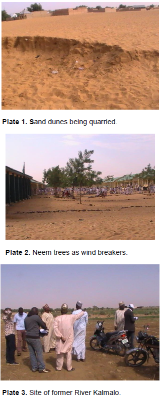
There was an expansive sand deposition around the Government Day Secondary School premises, Illela (Plate 1). High wind currents, lifting and carrying sand particles were observed in this area. This informed the earlier effort of the school authority to plant Neem trees around the premises as wind breakers (Plate 2). Neem trees are drought-resistant and are common landscape features, often grown to serve as shelterbelts and sun shield in the northern parts of Nigeria (Adesina and Gadiga, 2014).
In Kalmalo village, the former site of River Kalmalo (Plates 3 and 4), which is now dried up, once served as a source of fishing and irrigation for the local people. Findings from the Focus Group Discussions revealed two factors to be responsible for the drying up of River Kalmalo. First, the river was fed by River Magiya Lamido in Niger Republic, which was dammed at the upstream in the Niger, thus cutting off the source of River Kalmalo. Second, the river dried up due to secondary reason of sand deposition and siltation.
The villagers had therefore resorted to digging wells and drilling boreholes for their livelihood and dry season irrigation farming activities - an essential part of the socio-economic activity of the people; and, also to develop shelterbelts. According to Adesina and Gadiga (2014), shelterbelts are the most effective and environmentally friendly approach to achieving success in combating desertification in the arid and semi-arid environments.
Gada local government area
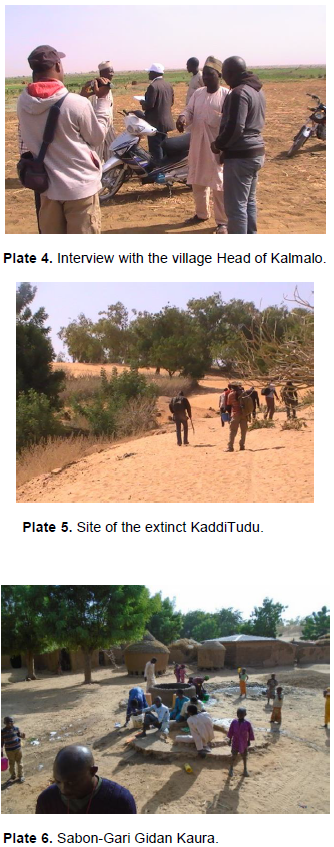
Plate 5 is the site of historic Kaddi Tudu village that was submerged overnight by rapid deposition of sand. Due to the tragedy, the community re-settled in
Sabon-Gari GidanKaura (Plates 5 and 6). Enormous deposits of sand with elevation up to 338 m were observed at Kaddi Tudu, which contrasted sharply with the new settlement - Sabon-Gari GidanKaura, with an elevation of 284 m. It was observed that the neem plantation in the area was failing but still shelters the soil from erosion by reducing the rate of sand movement. The local people also made wells and boreholes to irrigate their farmlands and the shelter trees, to reduce desertification.
Tangaza local government area
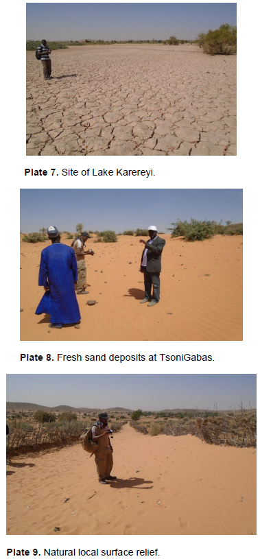
At Ruwan Wuri, it was observed that deposition of sand takes place intermittently, settling on and destroying crops. The only lake in the area called Lake Karereyi (Plate 7), has dried up in response to the prevailing dry season. At Tsoni Gabas, the team observed a large area of fresh sand deposits (Plate 8) caused by the presence of hills and mountains acting as natural interceptions; and, farm fences acting as barriers to sand transport.
In contrast to the areas earlier visited, there were no noticeable planted shelterbelts to provide shelter from the wind and to protect soil from erosion in the whole area.
Rather, the natural surface relief and farm fences acted as barriers to sand transport, leading to sand deposition and dune formation on the landscape (Plate 9).
Impacts on sustainable livelihood
Out of the total questionnaire administered, 162 copies were recovered while only
78 were valid . The low validity could be attributed to the low level of education among many of the respondents. The interviewees expressed strong conviction that desertification poses a direct threat to their environmental sustainability, which validated and further established the findings from the questionnaire. Table 1 shows that 67 respondents, making 86% of the total sampled were aware of the impacts of desertification while 14% claimed not to be aware. The high rate of awareness of the impact of desertification will explain why 79% of the respondents believed desertification affected their economic livelihood and 69% believed that the rate of desertification has increased over the years. Even though, 90% agreed desertification affected agricultural production, farm yields over the years in the area were considered to have increased by 60% of the respondents, while 40% of the respondents considered farm yields have decreased. The increase in farm yield may not be unconnected with the prevailing practice of irrigation with which water sourced from wells and boreholes are used in irrigating farmlands off rainy season.
In Table 2, 67% of the respondent believed desertification is contributing to underdevelopment in the community and 85% of the respondents informed of the determination of the members of the local communities to reduce the rate of desertification, through the cultivation of tree plantation as agreed to by 92% of the respondents. A majority represented by 73% believed desertification is affecting the health and safety of the people living in the community.
Some of the effects are the frequent overrunning of farmlands and the communities by sand as agreed to by 80% of the respondents. Despite the menace that desertification poses in the communities, 83% of the respondents believed there has been an increase in the local population in the last 10 years.
In Table 3, it can be observed that the vegetation in the communities is being lost to desertification, caused by sand deposition as indicated by 73% of the respondents. This was corroborated by all the respondents, who said firewood and charcoal are predominantly used for domestic cooking. Nevertheless, other respondents (79%) agreed government is embarking on tree planting, dam construction and irrigation projects in the area. There was a general belief (68%) that rainfall has decreased, while 84% believed that temperature has increased in recent time in the study area. There was an overwhelming belief by 95% that the area continues to suffer from sandstorms and deposition. This was visibly confirmed by the presence of sand dunes in most of the areas visited by the research team.
Elevation changes
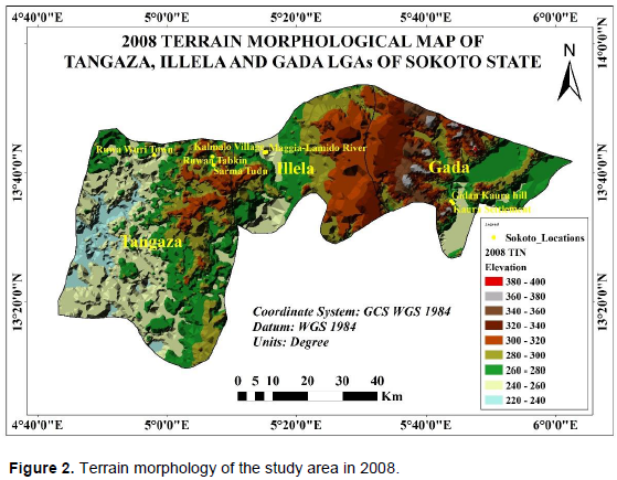
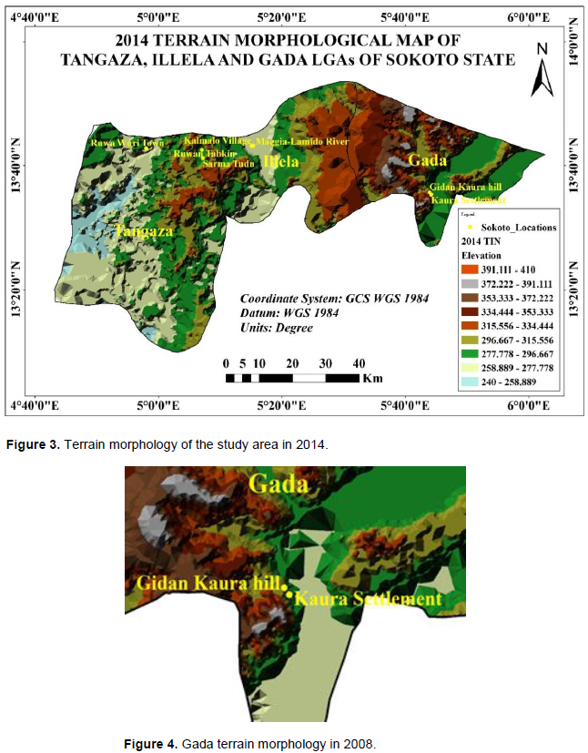
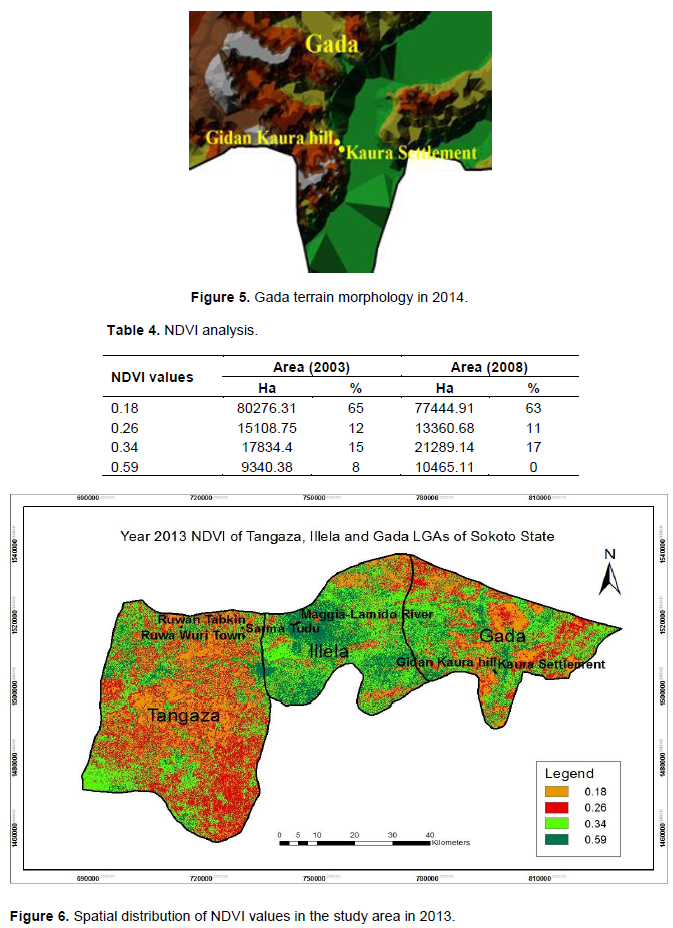
The Digital Elevation Model (DEM) of Tangaza, Gada, and Illela Local government areas of the year 2008 and 2014 are derived from ASTER images (Figures 2 and 3). From the two elevation images it can be clearly observed that the elevation of the areas is rapidly changing. It is clearly noticed that in the 2008, the highest height in GidanKaura Settlement in Gada local government was about 380 metres above sea level (Figure 4). However, by the year 2014 the terrain morphology map indicated changes in the height of the area in Gidan Kaura settlement was about 410 metres (Figure 5). Therefore, these results indicated that the Gidan Kaura hill grew by about 30 metres within the six-year period. Interestingly, these results correlated with the information obtained from the field survey at the Gidan Kaura settlement as expressed by the people living in the area that sand deposition has increased in recent time.
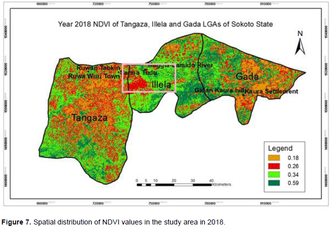
The findings show that the year 2018 had the highest NDVI values of 0.34 (17%) and 0.59 (9%). These NDVI values were higher than the values in 2013 with 0.34 (15%) and 0.59 (8%) respectively (Table 4). The NDVI values range between -1 and +1, while numbers between 0 and -1 suggest non-vegetated surfaces or distressed vegetation; healthy vegetated surfaces have NDVI values tending towards +1. The differences in the NDVI findings in this study can be attributed to the increase in farm yield, which may not be unconnected to the prevailing practice of irrigation in the northern parts of Nigeria (Ajiboye and Osundare, 2015). The farmlands and shelterbelts in the study area were irrigated with watersourced from wells and boreholes. However, it is important to note that the decreased NDVI values observed in the year 2018 in Tangaza and Illela Local areas (Figure 6) as against the NDVI values in Figure 7 can be attributed to drought. The drought was occasioned by the loss of water from River Magiya Lamido that was dammed in Niger Republic. The daming cut off the source of River Kalmalo, and in addition to sand deposition and siltation, the river dried up.
The study was able to establish that desertification is real and impacting negatively on the sustainable livelihood of the people in the study area. The findings from field work confirmed that there is frequent deposition of sand that destroys crops and causes siltation in the open surface waters in the communities. However, desertification was not seen to be advancing due to the effort of both government and the local inhabitants to farm the surfaces of the dunes and other sand depositions. Farming of the surfaces of the sand dunes ensures continuous food provision and further, leads to soil compaction, which slows down sand transport. Other efforts at halting expansion of sand dunes and improving the livelihood of the people included the creation of shelterbelts and fences that act as barriers to widespread sand transport and deposition. Therefore, there is an urgent need for increased commitment to tree planting and proper management of existing shelterbelts to mitigate desertification in the affected areas. There is also the need for government to invest more in water project, especially for dry season farming and irrigation to sustain agricultural production that will promote sustainable livelihood of the people. This will also lead to increased greenery in the affected areas, which is able to slow down desertification. Desertification constitutes a significant menace to pastoralism and agriculture which are the major sources of food provisioning and livelihood in the affected local communities. If left unmonitored and unchecked, this situation may lead to a full-blown desert condition with all its attendant negative impacts on the people and sustainability of the environment.
The authors have not declared any conflict of interests.