Full Length Research Paper
ABSTRACT
Since the beginning of twentieth century, mountain glaciers have generally experienced worldwide retreat and thinning in response to ~0.74°C increase in global mean surface temperature. Consequently, additional fresh water is released from glacier storage that modifies current stream flow regimes. Water resources play a key role in the sustainable development of human activities and for preserving the ecological environment in the Kashmir valley. Glaciers have a substantial influence on the local water cycle by temporarily storing water as snow and ice on many different time-scales. Scientific communities and sectors of water resources management have recently recognized the strong influence of glaciers on catchment runoff quantity and distribution. In this backdrop, an attempt has been made to examine how climatic change influences glacier behaviour and the water quantity from its discharge. A study of the Kolahoi Glacier, Liddar Headwater, Kashmir Himalayas, is presented here. The study was carried out using Remote Sensing and Geographic Information Systems (GIS) techniques. The Kolahoi Glacier shows a faster retreat than other Kashmir Himalayan glaciers. The area of the glacier receded from 11.22 km² in 1992 to 9.80 km² in 2010, registering a change of 1.42 km2 in 18 years at a rate of 0.078 km2 per year. As the glacier is receding very fast during the recent time its discharge also shows an increasing trend. The result of this retreat will prove disastrous for the valley in a number of ways like drinking water, agriculture, horticulture, ground water, hydro power capacity of the state, etc. Therefore, efforts need to made to save this precious source of water for the present as well as for future generations.
Key words: Climatic change, remote sensing, Kolahoi Glacier, Liddar, Kashmir Himalayas.
INTRODUCTION
Glaciers are dynamic and fragile ice bodies on the landscape which have changed in the past and will continue to change in response to the pulsations in the climatic scenario. Change in climate is clearly reflected in mass and temperature changes of glaciers. Hence, the perennial land ice bodies are considered the key for climate system studies. Glacier advancement and recession are the most significant evidences of change in glacier geometry. Shifting of snout position of glacier as a response to climatic changes is the best indicator of glacier advancement and recession over a period of a few years or decades. During Pleistocene period, the glaciers occupied about 30% of the total area of earth as against 10% area at present (Flint, 1964). Glaciers are retreating in the face of accelerated global warming resulting in the long-term loss of natural fresh water storage. Since industrialization, human activities have resulted in steadily increasing concentrations of greenhouse gases in the atmosphere, leading to fears of enhanced greenhouse effect. As a result of greenhouse gas effect, the world’s average surface temperature has increased between 0.3 and 0.6°C over the past hundred years (Samjwal et al., 2006) as a result of which, the mountain glaciers have thinned, lost mass, and retreated. The Intergovernmental Panel on Climatic Change (IPCC) has stated that thinning of glaciers since the mid-19th century has been oblivious and pervasive in many parts of the world. The panel in its third assessment report revealed that the rate and duration of the warming in the 20th century is larger than at any other time during the last one thousand years. According to the IPCC (2001) and their assessments based on climate models, the increase in global temperature will continue to rise during the 21st century. The increase in the global mean temperature by 2100 could amount to anything from 1.4 to 5.8°C, depending on the climate model and greenhouse gases emission scenario (IPCC, 2001). On the Indian sub-continent, average temperatures are predicted to rise between 3.5 and 5.5°C by 2100 (Lal, 2002). An even higher increase is assumed for the Tibetan Plateau. These changes in climate will inevitably interact with changes in glacier. The climatic fluctuations affect both the amount of snow and ice stored in, and the quantities of meltwater runoff arising from the glaciers. A forecast was made that up to a quarter of the present global mountain glacier mass could disappear by 2050 and up to half could be lost by 2100 due to global warming (Kuhn, 1993; Oerlemans, 1994). For example, with the temperatures rise by 1°C, Alpine glaciers have shrunk by 40% in area and by more than 50% in volume since 1850 (CSE, 2002). A decrease of glacier mass of this magnitude presents a serious water resources problem for the millions of people living within the Himalayan region and in the adjoining plains. Glaciers in the Himalaya are receding faster than in any other part of the world.
The receding and thinning of Himalayan glaciers can be attributed primarily to the global warming due to increase in anthropogenic emission of greenhouse gases. The relatively high population density near these glaciers and consequent deforestation and land-use changes have also adversely affected these glaciers (IPCC, 2007).
The distribution of snow accumulation in mountain regions is one of the most important controls in mountain river hydrology. The variability of snow accumulation makes accurate information on snowmelt processes difficult to obtain. The amount of snow and ice melt contributions in Himalayas vary from year to year depending on the amount of precipitation at high altitudes and the prevalent environmental conditions during the melt season. Glacier discharge is dominated by melt water runoff. The amount of precipitation in the form of snow has an inverse effect on the amount of runoff. Fresh snow is highly reflective so that it absorbs less heat and melts slowly, while old snow and glacier ice have a low reflectivity. Thus, greater the precipitation in the form of snow, longer than the glacier is covered by a highly reflective material, and less than the runoff. A decreased amount of snowfall leads to a low-reflective surface being exposed longer, producing greater melt and increased runoff. There can be a considerable variation in discharge from year to year which are usually the result of fluctuations in glacier mass balance, with weather conditions and ablation rates in the summer being the most significant.
METHODOLOGY
Study area
The Liddar catchment occupies the south eastern part of the Kashmir valley (Figure 1) and is situated between 33° 45′ 01″ N - 34° 15′ 35″ N and 75° 06′ 00″ E– 75° 32′ 29″ E. The Liddar valley forms part of the middle Himalayas and lies between the Pir Panjal range in the south and south-east, the north Kashmir range in the north-east and Zanskar range in the southwest. The Liddar valley has been carved out by river Liddar, a right bank tributary of river Jhelum.
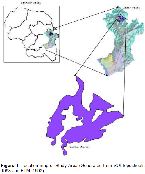
It has a catchment area of 1159.38 km2, which constitute about 10% of the total catchment area of river Jhelum. The valley begins from the base of the two snow fields, the Kolahoi and Sheshnag, where from its two main upper streams; the west and the east Liddar originate and join near the famous tourist town of Pahalgam. It joins the Jhelum (upper stream of Indus river) at Gur village after travelling a course of 70 km. The area gradually rises in elevation from south (1600 m) to north (5425 m). The study area reveals a variegated topography due to the combined action of glaciers and rivers. The valley possesses distinctive climatic characteristics, because of its high altitude location and its geophysical setting, being enclosed on all sides by high mountain ranges. The valley is characterized by sub-Mediterranean type of climate with nearly 70% of its annual precipitation concentrated in winter and spring months.
Data set and method
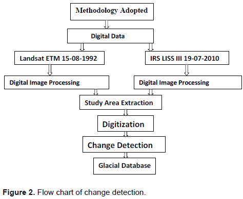
In the present study, the dataset consists of the geometrically corrected Landsat ETM imagery (1992) with the resolution of 30 m, the geometrically corrected IRS 1C LISS III (2010) imagery with the resolution of 23.5 m, the meteorological data of the Liddar valley and the discharge data from the Kolahoi Glacier at Aru (west Liddar). The research was carried out, utilizing the techniques of Remote Sensing and GIS in the Erdas Imagine 9.0& Arc view 3.2a.
Before using the satellite imageries for analysis, each image was geometrically corrected and different contrast enhancements were used to enhance the interpretability of the images. The base map was prepared from ETM satellite image for the year 1992. The spatial extent of the glacier is delineated and digitized in the Arcview3.2a. The map prepared from 2010 satellite image is then superimposed on the base map prepared from 1992 satellite image in a GIS environment and the third layer was created by identifying the changed area. The findings are presented in the form of change detection map. Image selection for glacier mapping is guided by acquisition at the end of the ablation period, cloud-free conditions, and lack of snow fields adjacent to the glacier. Visual interpretation of the images has been carried out based on standard photo interpretation methods, and subsequently, digital image processing has been carried out. The images were visually interpreted, using the clues such as tone, color, texture, pattern, shadow, shape, and association, etc. To differentiate between the clouds and snow/glaciers, various color composites were analyzed. Although, all the remote sensing data were received in August and September, the seasonal snow was obvious on the images. On satellite images, glacial boundary was mapped using standard combinations of bands such as band 2 (0.52 to 0.59 mm), band 3 (0.62 to 0.68 mm) and band 4 (0.77 to 0.86 mm). Image enhancement technique was used to enhance difference between glacial and non-glacial area. Annual mean maximum and mean minimum temperature in degree Celsius (°C), and total precipitation in millimeters were calculated from year 1980 to 2010 based on the data acquired from India Meteorological Department, Srinagar. The discharge from Kolahoi Glacier (Obtained from Flood and Irrigation Department, Srinagar) was observed at the Aru-Liddar Head. The resultant data have been presented in the form of charts in order to analyze the pulsations in the climatic variables. The methodology employed for the change detection in the spatial extent of the glacier is as shown in Figure 2.

RESULTS AND DISCUSSION
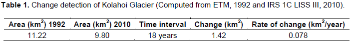
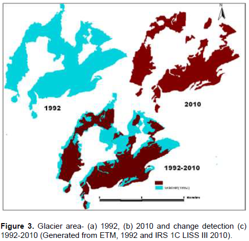
Glaciers in the Kashmir valley are in a state of fast retreat. The same process of retreat is found in the Kashmir valley’s largest glacier, Kolahoi (Liddar valley). Kolahoi Glacier is receding very fast due to changes that have been taking place in the climate at global level and Kashmir valley in particular. The study reveals that there has been a considerable change in the spatial extent of the glacier under study from 1992 to 2010 (Table 1 and Figure 3a, b, c). In 1992, the area of the Kolahoi Glacier was 11.22 km2, which receded up to 9.80 km2 in 2010, showing a net change of 1.42 km2 in 18 years with an average retreating rate of 0.078 km2 per year.
Climate variability in Liddar valley
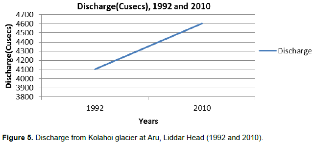
The average annual maximum temperature in the Liddar valley was 15°C in 1980 which increased to 18.0°C in 2007 and 18.3°C in 2010. The trend is consistent with the annual minimum temperature, which increases from 1.82°C in 1995 to 4.63°C in 2007 and 4.66°C in 2010. Increase in temperature conditions are corresponded by a declining trend in precipitation of the study area. The precipitation decreases from 1231 mm in 1980 to 1147 mm in 1985. It further decreases from 1371 mm in 1992 to 921 mm in 2007 and 917 mm in 2010 (Table 2). The increase in temperature (both annual maximum and minimum) and decrease in precipitation in the Kolahoi Glacier valley may have resulted in enhanced glacier ice melt. The total annual discharge from the Kolahoi Glacier increases from 3140 cusecs in 1980 to 4100 cusecs in 1992. It further increases from 3347 cusecs in 1995 to 4574 in 2007 and 4602 cusecs in 2010 (Table 2). It is evident from Figure 4 that anomalously high rates of glacier shrinkage have resulted due to the climatic warming. Furthermore, high rates of glacier shrinkage in the study area have resulted in high runoff which is shown in Figure 5. The temperature, precipitation, and discharge trends in the Liddar valley are shown in Figure 6. The trends indicate that the annual total discharge during the given years will increase with the increase in temperature (both annual maximum and minimum) and decrease in precipitation.
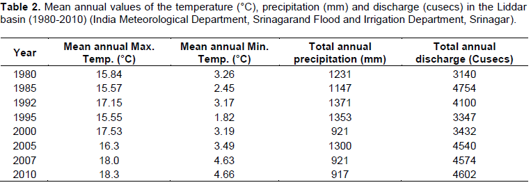
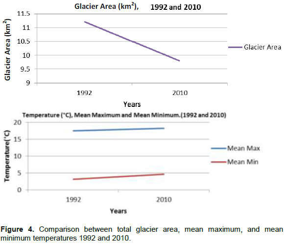
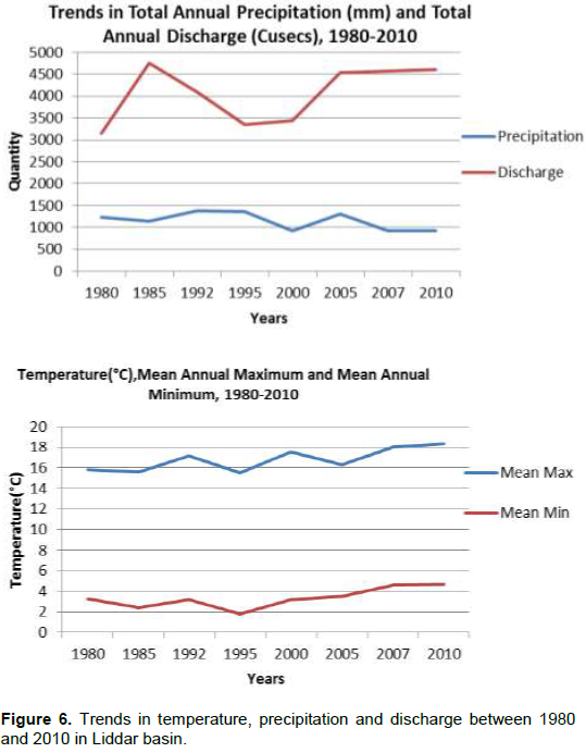
The analysis of climatic factors of the study area shows the recession is coherent with the warming trend. It can be said that, increasing trend of both minimum and maxi-mum temperatures are responsible for areal decrease with the effect of melting. Furthermore, the precipitation values over years have also shown a declining trend. This may be because of the decline in the relative humidity in the study area. The alarming increase in mean maximum temperature in Liddar valley induces rapid melting of snow, whereas the increase in mean minimum temperature does not allow glaciers to freeze to required extent and ultimately affects its life span. The mean annual values of temperature, precipitation and discharge for the years 1980 to 2010 in the Liddar basin are shown in Table 2.
CONCLUSIONS
Glaciers are in the process of retreat in almost all the parts of the world due to global warming. The same process of retreat is found in the valley’s largest glacier, Kolahoi. Its area in the year 1992 was 11.22 km² which receded up to 9.80 km² in the year 2010, a net decrease of about 1.42 km² in 18 years at the rate of 0.078 km2 per year.
The hydro meteorological data of the study area shows an increase in the mean maximum and mean minimum temperatures and a decrease in the precipitation pattern. The annual mean maximum temperature increases from 15.84°C in 1980 to 18°C in 2007 and 18.3°C in 2010. The annual mean minimum temperature increases from 3.26°C in 1980 to 4.63°C in 2007 and 4.66°C in 2010. The precipitation declines from 1231 mm in 1980 to 921 mm in 2007 and 917 mm in 2010. This alarming increase in mean maximum temperature in Liddar valley induces rapid melting of snow, whereas the increase in mean minimum temperature does not allow glaciers to freeze to required extent and ultimately affects its life span. Increase in temperature conditions is facilitated by a corresponding declining trend in precipitation. Variations in the Kolahoi Glacier depend strongly on the temperature conditions. Therefore, in the case of low precipitation, rising temperature will reduce accumulation and this intensifies the ablation increase. Glaciers are important storage of fresh water in Kashmir as they accumulate mass; particularly, in the winter and provide melt water at lower elevation. The importance of glaciers is not only limited to Kashmir only: all the water from Jhelum finally falls in the Indus. Therefore, any significant change in glacier mass is certain to impact water resources on a regional level.
The discharge data from the Kolahoi Glacier at Aru shows a net increase in its discharge. This is due to the increase in the glacier melt and subsequent runoff. The total annual discharge from the Kolahoi Glacier increased from 3140 cusecs in 1980 to 4574 cusecs in 2007 and 4602 cusecs in 2010. The large increase of glacial melt water is also testified by the breaking of glacial ice at several places in Kolahoi Glacier.
Kolahoi Glacier is receding at a very fast rate due to both anthropogenic and natural causes like increase in temperature, deforestation, tourism, increased activity of Gujjars and Bakerwals, high levels of pollution caused by the emission of greenhouse gases, military vehicular movement, cement plants, etc. The result of this retreat will prove disastrous for the valley in many fields like drinking water, agriculture, horticulture, ground water, hydro power capacity of the state, etc. Therefore there is a need to make efforts to save this precious source of water for the present as well as for future generations.
CONFLICT OF INTERESTS
The authors did not declare any conflict of interests.
ACKNOWLEDGEMENT
The authors are is highly thankful to the Indian Meteorological Department, Srinagar, Flood Control Department, Srinagar and Department of Geography and Regional Development, University of Kashmir, Srinagar for providing necessary data and facilities. The authors further suggest that there is no conflict of interest.
REFERENCES
|
CSE-Center for Science and Environment (2002). Melting into Oblivion, Down To Earth, 15 May 2002 China Daily, 23 September 2004. |
|
|
Flint RF (1964). Glacial and Quaternary Geology, John Wiley, pp. 63-85 |
|
|
IPCC (2001). Climatic Changes 2001: The Scientific Basis. Contribution of Working Group I to the Third Assessment Report of the Intergovernmental Panel on Climate Change (Houghton J. T., Ding D.J., Griggs M. and Johnson C.A., Cambridge University Press, U.K., USA. NY. P. 881. |
|
|
Kuhn M (1993). Possible future contribution to sea level change from small glaciers. In: Climate and Sea Level Change: Observations, Projections and Implications (Eds. R.A. Warrick et al.) Cambridge University press, Cambridge, UK. pp. 134-143. |
|
|
Lal M (2002). Possible impacts of global climate change on water availability in India. Report to Global Environment and Energy in the 21st Century. New Delhi: Indian Institute of Technology. |
|
|
Oerlemans J (1994). Quantifying global warming from the retreat of glaciers. Science 264:243-245. |
|
|
Samjwal RB, Pradeep KM, Basanta RS (2006). The Impact of Global Warming on the Glaciers of the Himalayas. International symposium on Geo-disasters, infrastructure management and protection of world heritage sites, 25-26 Nov 2006, Nepal Engineering College, Ehime College and National Society for Earthquake Technology Nepal Proceedings. pp. 1-12. |
|
Copyright © 2024 Author(s) retain the copyright of this article.
This article is published under the terms of the Creative Commons Attribution License 4.0


