ABSTRACT
There is a growing awareness on the importance of indigenous technical knowledge and the necessity of its integration into modern knowledge in order to address problems related to natural resource conservation. However, there is a lack of study that demonstrates clearly how the two types of knowledge systems could be successfully integrated together. This paper presents such a framework that has been developed through a participatory geographical information systems (GIS) approach with the Teso Community in Kenya. Data were collected using a variety of research instruments such as structured questionnaires, in-depth and face-to-face interviews, focussed group discussions, content analysis of literature, environmental check lists, and using the GIS techniques for assessing the status of the bio-physical environment. The process of developing such a framework comprises five key building blocks including stakeholder engagement, establishment of resources targeted for rehabilitation, establishment of community and scientific points of convergence and divergence, a decision on community and expert resolutions and the adoption of community-based project implementation, and monitoring and evaluation. The study recommends that the developed framework could be easily replicated with other rural communities that have similar bio-physical environmental conditions if found successful in sustainably managing natural resource management.
Key words: Indigenous technical knowledge, geographical information systems (GIS), natural resource management.
Theobald et al. (2015) and Tallis and Lubchenco (2014) submit that the long term success of conservation initiatives aimed at halting the accelerating losses of biodiversity habitats hinges on a pluralistic and interdisciplinary cause of action where both indigenous technical knowledge and conventional conservation systems are considered alongside each other. Indigenous technical knowledge, according to Ceballos et al. (2015) and Rogers and Campbell (2015) if integrated with the conventional conservation knowledge systems, can greatly contribute to sustainable natural resource management among local communities.
Sousa (2013) and Winkel et al. (2015) have echoed the above by noting that sustainable natural resource management may be well served by a system that incorporates both indigenous and scientific knowledge systems. Furthermore, Hiwasaki et al. (2014) have argued that the indigenous and scientific knowledge systems do complement each other on their strengths and weaknesses and their integration would achieve more in natural resource conservation than neither in their separation.
Loh and Harmon (2014) and Lwoga (2011) say that indigenous/ local people often possess detailed indigenous technical knowledge of natural resources and the ecological value of individual plants that can assist policymakers in designing suitable natural resource management policies and frameworks. They argue that members of such communities have also acquired a comprehensive knowledge of how different plants and animals adapt to changing environments within the landscapes they inhibit.
However, Chepkosgey and Jerotich (2016) and Nabhan (2016) submit that in most developing countries indigenous technical knowledge has long been ignored and much criticized as having no role in enhancing modern science related to biodiversity conservation. This argument corresponds with the views by Lwoga (2011) and Gaillard and Mercer (2012) who have pointed out that indigenous technical knowledge among local communities is getting marginalized and thus it is disappearing and may soon become extinct due to poor incorporation or non-incorporation into scientific related knowledge through appropriate approaches such as participatory geographical information systems (GIS). One major factor contributing to the above dissatisfaction is the lack of a key model involving the creation of a core boundary-spanning team, community facilitators, a policy facilitator, and trans-disciplinary researchers responsible for linking with a wide range of actors ranging from local to global scales (Weis and colleagues, 2013). According to the Republic of Kenya (2013-2017), Ayaa (2013) and Kangalawe et al. (2014) such communities including the Teso community have a wealth of indigenous technical knowledge with regards to:
i) identification of issues affecting natural resources, and ii) suggesting practical solutions to overcome them. Indigenous Technical Knowledgem which according to Kangalawe et al. (2014) consists of the beliefs and understandings of non-western people acquired through long term association with a particular place, is thus critical in sustainable natural resource conservation. Ayaa and Waswa (2016) have already demonstrated the critical role played by indigenous technical knowledge systems in the conservation of the biophysical environment in Kenya in general and among the Teso community of Busia County in particular. The result of the study above showed the importance of involving local community members in the process of designing an integrated framework through participatory GIS mapping and environmental issues solving. In view of the foregoing the above study recommended a need for a new integration framework that would more successfully incorporate scientific and local knowledge for sustainability in natural resource conservation in different agro-ecosystems. This study attempted to establish a relationship between trends in the use of indigenous technical knowledge for environmental conservation among members of the Teso community and the land use-land cover status overs a period of 37 years spanning from pre-independence to the 2000s.
It is in light of the above that the study sought to: i) highlight the importance of indigenous technical knowledge and ii) draw a key procedural approach to successfully combine indigenous technical knowledge and scientific knowledge for sustainable natural resource management using the Teso community as a case study area in Kenya.
Literature review
Hiwasaki et al. (2014)-say that today, the literature on traditional technical knowledge has gained rapid currency as researchers and natural resource managers have increasingly considered it as a valuable contributor to natural resource management and biodiversity conservation. Popova (2014) notes that, this form of knowledge also goes by other names such as Traditional Ecological Knowledge (TEK) Indigenous People’s Knowledge (IPK) and even ‘folk knowledge’. Camara-Leret et al. (2014) observe that the iterations and mechanisms of indigenous technical knowledge are unique to each community even where it shares certain features across groups by virtue of it being embedded in a wider common culture. In all locations, indigenous technical knowledge is the foundation of indigenous governance, ecological stewardship, social, ethical, linguistic, spiritual, medicine, food and economic systems.
Accordingly, such knowledge is contained in and expressed through dance, songs, stories including those referred to as myths or legends, proverbs, foods, institutions, skill sets, practices, beliefs, ceremonies, innovations and adaptations, languages, codes of ethics, protocols, art forms and laws as argued by Egeru (2011).
Knowledge integration process
Theobald et al. (2015) and Shrestha and Medley (2016) have noted that the importance of combining indigenous technical knowledge and scientific knowledge systems for natural resource management is reflected in the widespread adoption of international strategies that establish a link between poverty alleviation, sustainable development and biodiversity conservation including the Convention on Biological Diversity and the Ramsar Convention on Wetlands among others. In view of the above, the recent Global Strategic Plan for Biodiversity (2011-2020) declared in the COP 10 (Strategic Goal E, target 18) recommended that by 2020, traditional technical knowledge, innovations and practices of indigenous and local communities relevant for the conservation and sustainable use of biodiversity, and their customary use of their biological resources should be respected, subject to national legislation and relevant international obligations, and fully integrated and reflected in the implementation of the convention with the full and effective participation of the indigenous and local communities, at all relevant levels.
McShane et al. (2011) and Sandker et al. (2012) have recommended that an appropriate model for effective knowledge integration should enable the achievement of the following objectives: i) promote collaborative research-facilitator community teams, ii) integrate local and scientific knowledge, iii) help community and policy makers improve their living standards, iv) expand biodiversity payment schemes, v) develop multiple land-use plans, and vi) engage fully the stakeholders together in multiple land use policies. Besides, several integration frameworks have been developed in the past by scholars such as Gaillard and Mercer (2012), Sousa (2013), Spiller et al. (2012) all aimed at integrating indigenous technical knowledge and universal conservation knowledge. Despite the existing frameworks being participatory in nature and adopting the use of conventional methods of data collection including interviews, observation and review of documented information relating to a chosen local community, Shrestha and Medley (2016) submit that such models have not been very successful in achieving sustainability in natural resources management since they have tended to remain Westernized-Scientific in nature with inadequate local community participation.
Sousa (2013) notes that rather than treating the two knowledge systems as complementary to each other, the available integration models have often dealt with these knowledge systems as separate approaches rather than a hybrid thereby rendering the model less effective in sustainable natural resource conservation. Furthermore, Fleischmann et al. (2014) have identified a major weakness of the existing frameworks as being lack of detailed understanding of the epistemology resulting in only superficial interactions between indigenous and scientific knowledge holders. They found out that the existing frameworks have been developed based on the patterns of superficial engagement between local community members and the scientific researchers has often perpetuated power struggles thereby leading to stunt collaborative efforts.
According to Weiss et al. (2013) the process of designing an integrated framework must not only attempt to understand basic needs of local stakeholders but should seek to empower local community members. This is through providing local stakeholders an active voice in the conception, design, implementation and the management of the entire process. Inclusive consultation will assist in aligning the often multi-scale objectives of external and internal land users. Further, a successful integration framework for sustainable natural resources management demands that its design process should include participatory land use planning (PLUP) (Castella et al., 2014) participatory geographic information systems (PGIS) mapping, Boedhihartono and Sayer (2012) forum groups (Colfer and Pfund, 2012 and semi-structured interviews (Watts and Colfer, 2011). Brown and Kyttä (2014) submit that participatory GIS is useful in extracting lay (indigenous) knowledge and people’s views and perceptions regarding natural resources as well as presenting the same to environmental scientists and authorities.
Boedhihartono and Sayer (2012) note that PGIS as a technique has been used in understanding the factors that determine the level of change in a target natural resources, obtain detailed and current information locally on the resource characterization (size and dynamics) as well as understanding the value communities attach to their resources. Also, PGIS enables the reconstruction of information that can possibly account for the noted changes in certain resources within a given community or geographic region. In this regard PGIS is an important tool for incorporating local knowledge through active community participation in needs assessment, problem analysis and design of integrated approaches to implementing development since it facilitates feed-back from the local people (Shrestha et al., 2016). Henry and Dietz (2011) submit that sustainable natural resource conservation requires that biodiversity concerns be mainstreamed into the behaviour of individuals and communities that interact with these resources. They argue that the social issues and contexts (values, norms, institutions, organizations and human wellbeing) which underpin almost all conservation opportunities and constraints for implementation must be accorded much priority if sustainable natural resource conservation is to be achieved.
It is in this regard that Berkes (2012) says that the knowledge of local people has increasingly become indispensible in understanding the long term changes in natural resources. In view of the above, Weiss et al. (2013) and Fleischmann et al. (2014) argue that the current challenge is therefore to develop ‘a user-inspired’ and ‘user useful’ management approaches where local/ indigenous technical knowledge is considered alongside scientific knowledge. The above agrees with the earlier findings of a study by Bohensky and Maru (2011) who recommend that for sustainability in natural resource management to be achieved, the incorporation of indigenous knowledge into the mainstream approaches that enables the establishment of the causes and consequences of natural resource degradation through participation of local community members is critical.
A study by Bohensky and Maru (2011) has revealed that the integration of indigenous technical knowledge with scientific knowledge through active involvement of local communities provides a description of the current interactions between the human society and its natural habitat as well as the estimate of future developments. Furthermore, Inwood et al. (2015) posit that an understanding of how humans interact with and value their natural environment enables the identification of those behaviours that need to be reinforced or changed to safeguard biodiversity. It is in this regard that Wiseman and Bardsey (2013) have observed that just as scientific and biological assessments represent a defensible approach for identifying strategic conservation (the “where” problem), social assessment provides the kind of insights required to do the actual conservation (the ‘how’ problem).
Today, thus, given the actual and potential conflicts between biodiversity and the imperatives of socio-economic developments in most parts of the world, the need to incorporate the social assessment into conservation projects is all the more urgent. The above concurs with the sentiments by Ziembicki et al. (2013) who note that evidence abounds which suggests that sustainability in natural resource management can only be attained by developing a science based on priorities of local people by creating a technological base that includes both indigenous and modern approaches to conservation.
PGIS and knowledge integration
Brown and Fagerholm (2015) submit that practitioners and researchers around the world all of whom share the goal of empowering the under-privileged have adopted a variety of GIT and S techniques to integrate multiple realities and diverse forms of information to foster social learning, support two-way communication and broaden public participation across socio-economic contexts, locations and sectors. The above has spurred a rapid development in community-based management of spatial information through what is generally termed participatory GIS (PGIS) which evolved as a result of the merger of participatory learning and Action (PLA) methods with GIT and S techniques. PGIS practice is usually geared towards community empowerment through demand driven, user-friendly and integrated applications of geo-information and GIT in which maps and map products become primary conduits.
GIS as a technology is useful both in addressing the problems associated with the storage, analysis and processing of this knowledge as well as in the process of integrating indigenous and scientific information. Besides, Brown and Kytta (2014) argue that GIS mapping software is critical in linking information about where things are with information about what things are like. Thus, unlike a paper map where “what one sees is what one gets” a GIS map can combine many layers of information because it is a specialized set of ICT that helps manage and interpret data about an area’s resources and infrastructure including digital maps or images of a village, watersheds, or an entire country.
However, Weiss et al. (2013) have noted that despite the over-emphasized integration of the two knowledge systems for the conservation of biodiversity, such integration contains very few examples of the process and very little evidence of how these knowledge systems can actually be integrated. Correspondingly, Bohensky and Maru (2011) have noted that although the integration and use of Indigenous knowledge to inform contemporary environmental policy decisions and management solutions is a growing global phenomenon, there is little critical inquiry about how the interactions between scientific and Indigenous knowledge (IK) systems can be effectively negotiated for the joint management of social-ecological systems.
On the basis of the above, the designed integration framework for the Teso agro-ecosystem offers a potential solution to the gaps identified in the previously developed models that hitherto excluded or only minimally involved local communities in all its stages leading to community members not owning the process. The designed framework has ensured a common concern entry point where all stakeholders agree to seek solutions to problem/needs and which is built on shared negotiation process based on trust as recommended by Pfund et al. (2011).
The current framework also recognizes the aspect of multi-functionality which appreciates the fact that landscapes and their components have multiple uses and purposes each of which is valued in different ways by different stakeholders which has been emphasized by scholars such as Smith (2011). The designed framework has also ensured active participation by all stakeholders throughout the design circle in an equitable manner which is a pre-requisite to the attainment of optimal and ethical outcomes of the initiative. The current framework has also been developed taking cognizant of a participatory and user friendly monitoring systems that facilitates sharing of information that need to be widely accessible as recommends Salafsky (2011). More important is the fact that the framework ensures strengthening of stakeholder capacity which a rises from equal stakeholder engagement through PGIS that enables each stakeholder improve their capacity to judge and respond in platforms where experiences are shared within or among cites.
Study site
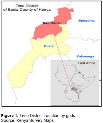
The study taking place around the Teso community in Kenya lies between latitude 0° 20 North and 0° 32 North and longitudes 34° 01 and 34° 07 East (Figure 1). Teso District is divided into four administrative divisions, namely Amagoro, Angurai, Chakol and Amukura, and covers a total land area of 558.5 km2. The district borders Bungoma County to the North and East, Busia District to the south and the Republic of Uganda to the West. It is a rural district where subsistence agriculture represents one of the main livelihood sources for the majority of the inhabitants of the region (Republic of Kenya, 2013-2017).
Research design
Target population/respondents
The respondents for this study were drawn from selected members of the Teso community, top government representatives of different relevant departments in the Teso District and top representatives of Non-Governmental and Private sector organizations. A total sample size of 384 respondents was selected based on Fischer’s formula (Creswell, 2014; Kothari and Garg, 2014). This consisted of a total of 289 household heads that were randomly selected from the two administrative Divisions within the Teso community of Busia County. Besides, 15 top government representatives from departments that operate on aspects related to environment and natural resources were also purposively selected to participate in the study. There was a special category of 80 respondents consisting of the elderly (Sages) aged seventy years and above who were purposely included in the study sample to help the researcher track the socio-economic and environmental trends in Teso District during the pre-independence and post-independence of Kenya. Both male and female respondents were included in the study sample.
Data collection methods
This research used several methods to collect data that included the following research administered questionnaires that were used to collect data from 249 household heads that were randomly selected in order to establish the Teso community indigenous technical knowledge systems and assess effects of changes in indigenous technical knowledge systems on the bio-physical environment through time.
Key informant interviews
Changes in the level of adherence to Teso community indigenous technical natural resource management knowledge systems through time were investigated by use of in-depth interviews with the representatives of related NGOs and private sector organizations.
PRA and focus group discussions
Focus group discussions and follow-up discussions in a workshop based set-up were carried out in order to cross-check the validity of the responses from the questionnaires and key informant interviews. Focus group discussion as a tool was particularly useful since it enabled brainstorming on emerging issues regarding trend in use of indigenous technical knowledge systems and perceived effects on the state of the bio-physical environment.
GIS spatial analysis and mapping
Spatial analysis based on remote sensing data was collected from LANDSAT TM and MSS from 1973 and 1986 for MSS and 2000 and 2010 for thematic mapper (TM) was used to map the land use and surface cover changes in the bio-physical environmental outlook. The use of remote sensing tools, software in this project such as ERDAS IMAGINE and ArcGIS toolkit facilitated the automation of the entire process which was run on unsupervised mode of classification in remote sensing.
The overall objective was to establish the changes in the Land Use/Land Cover in Teso District that may have been caused by changes in use of indigenous technical knowledge related to environmental conservation from 1973 to 2010. Participatory GIS was useful in extracting lay (indigenous) knowledge and people’s perceptions regarding natural resources and land degradation with a view of presenting it to the conservation scientists and authorities. The PGIS was useful in establishing and understanding the factors that determine the nature and level of change in the natural resources as well as enabling the researcher obtain information locally on resources characterization (size and dynamics) as well as in understanding the value the community attaches to their resources.
Secondary data
Extra data were obtained from secondary sources such as textbooks, newspapers, relevant journals and electronic sources such as the internet.
Data analysis methods
All questionnaire-based data were cleaned, coded and entered into SPSS for analysis. Analysis centred on cross-tabulation and correlation in order to ascertain the perceived relationship between the level of adherence to indigenous environmental knowledge systems and the land use-land cover status within the study area. Interview-based data were analysed qualitatively with narrative correlation being used in corroborating the results with questionnaire data in order to assess the relationship between trends in the use of indigenous knowledge, bio-physical environment. PRA and FGD data were transcribed and typed into word with themes and sub-themes based on the study objectives created.
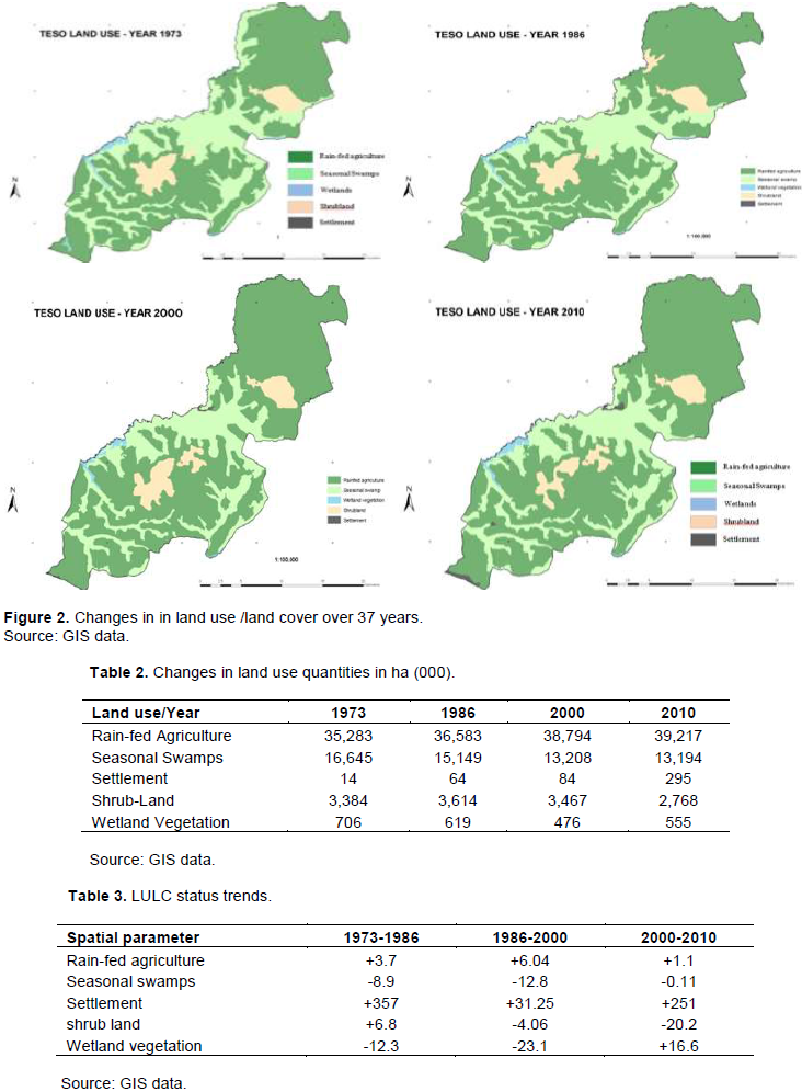
Analysis of GIS data involved acquisition of satellite images for Teso District and processing them using GIS standard procedure. Geographic information system and mapping techniques were used to track and obtain accurate, current and detailed information on how the status of the bio-physical environment has changed over the 37 years span in Teso District. The final output was maps and a table of quantities of changes in the amount of land under rain-fed agriculture, seasonal swamps, wetland vegetation, shrub land and settlement. This covered the years 1973, 1986, 2000, and 2010 (the only years for which satellite images for Teso were found/ available). The tools used were Erdas 9.1 Arcview GIS 3.2 and Arc Map software.
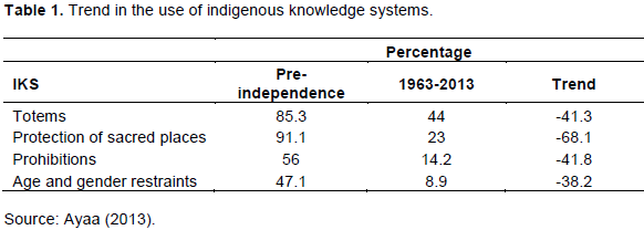
Table 1 shows the declining trends in the level of use of ITKs by the Teso community over a period of 37 years spanning from pre-independence period to post independence period. Interviews conducted with the target respondents in general and Teso community elders in particular revealed that level of adherence to the previously highly respected indigenous technical knowledge systems has declined over time. For instance most of the elders lamented that today, explosive population growth, modern education, modern religion and the break-down of traditional social system of leadership, indigenous knowledge and practices have come to be regarded as primitive and are associated with the dark past. Such attitudes especially by the youths and the educated have led to a decline in the adoption and use of indigenous knowledge systems from the 1960s to the 2000s era.
Spatial analysis results
The spatial analysis results are shown in Figure 2, Tables 2 and 3.
Prior to the arrival of the Missionaries, scientific discoveries, influence from foreign religions, modern education and industrialization, the Teso community spiritualism (the belief in the supernatural) created respect for animals, reverence for forests, rivers and mountains among others other natural resources. The beliefs gave some explanation as to why certain places were revered and certain activities tabooed. The community’s spirituality opined that natural phenomena have spirits that define the relationship between humans and nature that is inter-linked and independent. The clans had the responsibility to take care of and protect their land, sacred sites and their members’. These sites which were found in dense forests, wetlands, shrub lands, caves, river confluences among others were considered for special rites such as worship, naming of new borne babies, hunting, appeasing of ancestors, casting out of demons and evil spirits, uniting family members who had previously been separated due to certain cultural issues among other significance. This restricted certain forms of human initiated activities including farming, grazing and human settlement. Besides, there was belief in sacredness (things, situations and places that are deliberately set apart) which was highly upheld by members of the respective clans. This referred to respected places which are considered to be connected with supernatural and thus considered ‘super ordinary’. An important aspect of sacredness was the setting aside of patches of forests, ponds, parts of shrub lands among other designated sites by the traditional authorities for sustainable resource use and the preservation of vital biodiversity. In most cases the intention was to protect watersheds, fragile ecosystems as well as animals and plants that were considered to have cultural significance to the community. Arising from the above all community members irrespective of age, gender and religious affiliation highly observed indigenous beliefs and practices prior to Kenya’s independence as indicated in Table 1. From the year 1963-todate however, the exploding population growth and more importantly secularization of Teso culture have influenced most community members in general and the youth in particular not to take their culture as a yardstick in their lives. This has led to a continued decline in the level of adherence to indigenous beliefs and practices that hitherto greatly contributed natural resource conservation.
In this regard, traditional beliefs and practices that once facilitated the conservation of natural resources have come to be viewed as primitive, savage, archaic, animistic and backward paving way to a carefree attitude that has led to uncontrolled utilization of these resources. This has resulted to the current situation where community member of different genders, age, religion and socio-economic status engaging in uncontrolled farming, settlement, encroachment in forests and wetlands thereby affecting their quantities and quality.
However, it should be noted that since the later part of the 1990s, the government of Kenya upon noticing runaway destruction forests leading accelerated soil erosion commissioned tree plant activities around water towers among other designated sites resulting to increased size of land under wetland vegetation. This could have the implication that indigenous knowledge systems at level they are currently being used can no longer be used to effectively manage natural resources. It is in view of the foregoing that there is an urgent need to design an integration framework for mainstreaming these knowledge systems into scientific conservation systems for sustainable natural resource management.
Designing an appropriate integrated framework for combining IK and SK in natural resources management
In order to design an appropriate framework for integrated management of natural resources in the Teso community five ideal building blocks are presented below:
(i) Identification of conservation stakeholders/ partners for common understanding, trust and consensus building.
(ii) Establishment of changes in the status of the bio-physical environment
(iii) Scientific and Community points of convergence and divergence
(iv) Community and expert based resolutions
(v) Community based project implementation, monitoring and evaluation
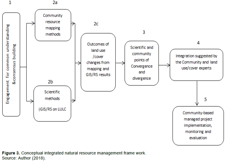
The above ideals can be presented as indicated below in which a conceptual model is reconstructed based on the main findings of the study.
Integration framework designing process
The designing of an integrated natural resource management frame-work for the Teso agro-ecosystem has been done with a participatory process in mind with the following key steps considered being critical. In all the steps consultation, deliberations, negotiation and consensus building between all the participating stakeholders were assumed to be inbuilt (Figure 3).
Step 1: Engagement for mutual Understanding and consensus building
Stakeholder engagement for identification of the community goal, mutual trust, establishment of rapport and building of common understanding on the impacts, and related effects driven by the land resources changes that requires rehabilitation.
Step 2: Establishment of changes in the status of the bio-physical environment
Step 2a: Community methodology: Community resource mapping was done to gain detailed and accurate current, past and projected trends regarding the status of natural resources purposely to identify land cover changes and consequent restoration areas. This was facilitated through participatory GIS where the community was engaged in drawing the maps based on their knowledge of the existence of the resources and changes and supplemented by structured in-depth questionnaires, key informant interviews follow up interviews and focus group discussions that focussed on the past, current and projected area of land under the five bio-physical environmental components identified, that is, wetlands, shrub lands, agricultural land, seasonal swamps and settlements.
Step 2b: Scientific methods: GIS/Remote Sensing time series analysis were done to track Land Use/Land Cover changes for the years 1973, 1986, 2000 and 2010.
Step 2c: Outcomes of Land use/cover changes: The GIS/Remote sensing time series analysis results in the maps as in Figure 3 and table of quantities (Table 2) above was then presented and discussed between all the participating stakeholders. The community outcomes on the resource mapping based on the structured in-depth questionnaires, key informant interviews, follow-up interviews and focus group discussions were presented in the graphical analysis in Figure 2.
Step 3: Scientific and community points of convergence and divergence
Through the use of PGIS techniques, both scientific and community outcomes were then jointly presented and thoroughly discussed to identify areas of similarities and differences with regard to what environmental elements that needed urgent rehabilitation. The community provided indigenous methods of conservation that have been used traditionally, as use of totems, prohibitions, protection of sacred places, age and gender restrains whereas the scientific methods agreed on prohibitions and protection. Alternative scientific or exotic methods for conservation were also presented and the community agreed on integration of these two methods to yield a hybrid solution with what is indigenously known but blended to yield more acceptable and productive results in conservation. The GIS arc maps, table of quantities and resultant figures showing changes in the identified features above were compared with the results from community mapping exercise bearing similar features with their relative sizes in the past and present.
Step 4: Community and expert based integration solutions
This involved identifying both indigenous and scientific strategies that have been used in the past and present to cope with associated natural resource degradation. The participating community members through the sages guided by the researcher anticipatorily listed all the indigenous environmental knowledge systems (IEKS) and Scientific knowledge systems (SKS) they had used in the past and those they are currently using in protecting the various components of the environment including:-Land management knowledge, vegetation conservation knowledge, water and wetlands management methods and knowledge for the protection of birds and wildlife. With regard to the members of the Teso community, indigenous knowledge systems such as use of totems, protection of sacred places, prohibitions as well as age and gender restraints were identified. The conventional methods suggested by the scientific community included the buffering of swampy areas through use of fences to discourage encroachment, rotational grazing and quarantine, protection of wetlands and wetland resources through legislative enactment, use of perimeter fence and community policing. The convergence of these methods was agreed upon to be the use of prohibition and protection in the conservation. The divergent methods identified were use of totems, age and gender restraints which were viewed as important pillars that can be used to reinforce the protection and prohibitions in many areas of interest.
Step 5: Community based project implementation, monitoring and evaluation
Detailed analysis of information in steps 2 and 3 above was done in order to negotiate and develop an integrated strategy for sustainable natural resource management. All participants engaged in an elaborate negotiation process regarding the mode/strategy of rehabilitation/ restoration of targeted resources as well as the designing of the monitoring and evaluation indicators for future tracking of the project progress.
The individual merit of each model/strategy was carefully evaluated in order to determine its future viability in restoring environmental status. Factors that guided discussions and negotiations of the viability of the integrated strategy include its sustainability, cost effectiveness, equity and stability among other considerations. The community representatives guided by the researcher then scored each of the selected strategies so as to arrive at a consensus regarding the most viable one. Once an agreement was reached, mobilization of the necessary resources was then undertaken and the actual implementation was jointly carried out. The above process resulted in the integration of the most successful indigenous and scientific strategies for sustainable environmental conservation and enhanced community livelihoods. It is therefore hoped that the implementation of this integrated strategy will lead to the restoration of the degraded components of the biophysical environment in a community such as the Teso.
In order to sustainably manage the scope, complexity and uncertainty of global natural resources, it is important to consider different types and sources of knowledge. Studies on the interface between social and ecological systems argue that Western paradigms and systems of knowledge are currently not able to deal with the full complexity of natural resource management nor sufficiently able to integrate local stakeholder perspectives in the development of natural resource management strategies. The challenge to most researchers has been to develop a ‘community-inspired and community-useful integrated management approaches whereby local knowledge is considered alongside scientific knowledge.
In order to design and implement an integrated environmental management framework, it is critical that all the participating stakeholders be made to have a common understanding regarding the targeted natural resource and the need to conserve it. The local community members will through the guidance of the elders use their indigenous knowledge to map out and analyze the natural resources targeted for conservation to ascertain the extent of degradation. The extent of damage is determined by the status trend size of land occurred by a specific environmental element of the status trend in the actual population of the elements targeted. An analysis to ascertain the points of convergence and divergence regarding the targeted natural resources are carried which is followed by the identification of appropriate indigenous and scientific conservation methods. The implementation of the two identified knowledge systems alongside one another therefore leads to an integrated environmental management framework.
(i) There is need for research to establish and document factors that inhibit successfully development of sustainable partnerships between local communities and the scientific community on issues of co-management of natural resources.
(ii) Policies and strategies to facilitate establishment of relationships based on mutual trust between various stakeholders in environmental conservation should be developed and implemented.
(iii) The design of a sustainable natural resource co-management framework should be developed with active participation of all primary stakeholders, among others so as to catch views, cultural contexts, needs, interests and strategies on management and use of biodiversity by the indigenous people.
The author has not declared any conflict of interests.
REFERENCES
|
Ayaa DD (2013). Effects of Changes in Indigenous Environmental Knowledge Systems on the Bio-Physical Environment and Community Livelihoods in Teso Distrct, Kenya. Unpublished PhD Thesis (Kenyatta University, Kenya).
|
|
|
|
Ayaa DD, Fuchaka W (2016). Role of indigenous knowledge systems in the conservation of the bio-physical environment among the Teso community in Busia County-Kenya. African Journal of Environmental Science and Technology 10(12):467-475.
Crossref
|
|
|
|
|
Berkes F (2012). Sacred Ecology. (3rd ed.). New York and London: Routledge.
|
|
|
|
|
Boedhihartono AK, Sayer J (2012). Forest landscape restoration: restoring what and for whom? In: Forest Landscape Restoration (eds Stanturf J, Lamb D, Madsen P), Springer, Dordrech, the Netherlands pp. 309-323.
Crossref
|
|
|
|
|
Bohensky EL, Maru Y (2011). 'Indigenous knowledge, science, and resilience: what have we learned from a decade of international literature on "integration"?', Ecology and Society 16(4):6.
Crossref
|
|
|
|
|
Brown G, Kyttä M (2014). Key issues and research priorities for public participation GIS (PPGIS): a synthesis based on empirical research. Applied Geography 46:122-136.
Crossref
|
|
|
|
|
Brown G, Fagerholm N (2015). Empirical PPGIS/PGIS mapping of ecosystem services: A review and evaluation. Ecosystem Services 13:119-133.
Crossref
|
|
|
|
|
Castella JC, Bourgoin J, Lestrelin G, Bouahom, B (2014). A model of the sciencepractice-policy interface in participatory land-use planning: lessons from Laos. Landscape Ecology 29:1095-1107.
Crossref
|
|
|
|
|
Camara-Leret R, Paniagua-Zambrana N, Balslev H, Macia MJ (2014). Ethnobotanical knowledge in vastly under-documented in Northwestern South America. PLoS ONE 9(1):e85794.
Crossref
|
|
|
|
|
Ceballos G, Ehrlich PR, Barnosky AD, García A, Pringle RM, Palmer TM (2015) Accelerated modern human-induced species losses: Entering the sixth mass extinction. Science Advances 1 (art. e1400253).
Crossref
|
|
|
|
|
Chepkosgey MP, Jerotich CG (2016) Trends for application of indigenous knowledge in natural resource management among Nandi people, Kenya. Journal of Environmental Science, Computer Science and Engineering Technology 5(3):513-527.
|
|
|
|
|
Colfer CJP, Pfund JL (2012). Collaborative Governance of Tropical Landscapes. Routledge, London, UK.
|
|
|
|
|
Cope M (2012). Public participation GIS as a cultural process: Cultural theory, participation preferences, and GIS-aided decision making among farmers in central Illinois. PhD dissertation, University of Illinois at Urbana–Champaign, Urbana, IL.
|
|
|
|
|
Creswell WJ (2014). Research Designs. Qualitative, Quantitative, and Mixed Methods Approaches (4th ed). Sage Los Angeles.
|
|
|
|
|
Egeru A (2011). The Livestock-poverty nexus: A discussion paper on ILRI research in relation to climate change. Kampala: Makerere University.
|
|
|
|
|
Fleischmann A, Michael TP, Rivadavia F, Sousa A, Wang W, Temsch EM, Greilhuber J, Muller KF, Heubl G (2014). Evolution of genome size and chromosome number in the carnivorous plant genus Genlisea (Lentibulariaceae), with a new estimate of the minimum genome size in angiosperms. Annals of Botany 114:1651-1663.
Crossref
|
|
|
|
|
Gaillard JC, Mercer J (2012). 'From knowledge to action: Bridging gaps in disaster risk reduction', Progress in Human Geography 37(1):93-114.
Crossref
|
|
|
|
|
Hiwasaki L, Luna E, Syamsidik SR (2014). Local and indigenous knowledge for community resilience: Hydro - meteorological disaster risk reduction and climate change adaptation in coastal and small island Communities Jakarta: UNESCO
|
|
|
|
|
Henry AD, Dietz T (2011). Information, Networks, and the Complexity of Trust in Commons Governance. International Journal of the Commons 5(2):188-212.
Crossref
|
|
|
|
|
Hiwasaki LL, Una E, Syamsidik SR (2014). Local & indigenous knowledge for community resilience: Hydro - meteorological disaster risk reduction and climate change adaptation in coastal and small island Communities Jakarta: UNESCO.
|
|
|
|
|
Inwood H, Fleming A, Pungetti G, Selman P Jongman R, Rackham MJ (2015). Econets, landscape and people (EcoLaP): Integrating people's values and cultural ecosystem services into the design of ecological networks and other landscape change proposals. Natural England Commissioned Report NECR180.
|
|
|
|
|
Kangalawe RYM, Noe C, Tungaraza FSK, Naimani G, Mlele M (2014). Understanding of traditional knowledge and indigenous institutions on sustainable land management in Kilimanjaro region, Tanzania. Open Journal of Soil Science 4:469-493.
Crossref
|
|
|
|
|
Kothari CR, Garg G (2014). Research Methodology. Methods and Techniques (3rd ed). New Age International (P) Limited Publishers, New Delhi.
|
|
|
|
|
Loh J, Harmon D (2014). Bicultural Diversity: Threatened Species, Endangered Languages. World Wide Fund for Nature Netherlands.
|
|
|
|
|
Lwoga ET, Ngulube P, Stilwell C (2011). Challenges of Managing Indigenous Knowledge with other Knowledge Systems for Agricultural Growth in sub-Saharan Africa. Libri 61(3):226-238.
Crossref
|
|
|
|
|
McShane TO, Trung, TC, Songorwa, AN (2011). Hard choices: Making trade-offs between biodiversity conservation and human well-being. Biology Conservation 144(3):966-972.
Crossref
|
|
|
|
|
Nabhan GP (2016). Passing on a sense of place and traditional ecological knowledge between generations. In Nabhan GP, ed. The Future of Ethnobiology: Linking Cultural and Ecological Diversity. University of Arizona Press Republic of Kenya (2013-2017). Busia County Integrated Development Plan. Government Printers, Nairobi.
|
|
|
|
|
Popova U (2014). Conservation, Traditional Knowledge, and Indigenous. American Behavioral Scientist 58(1). doi:10.1177/0002764213495043.
Crossref
|
|
|
|
|
Rogers C Campbell L (2015). Endangered languages. In Aronoff M, ed. Oxford Research Encyclopedia of Linguistics. Oxford University Press.
Crossref
|
|
|
|
|
Smith CB (2011). Adaptive management on the central Platte River—science, engineering, and decision analysis to assist in the recovery of four species. Journal of Environmental Management 92(5):1414-1419
Crossref
|
|
|
|
|
Sandker M, Ruiz-Perez M, Campbell BM (2012). Trade-offs between biodiversity conservation and economic development in five tropical forest landscapes. Environmental Management 50(4):633–644.
Crossref
|
|
|
|
|
Salafsky N (2011). Integrating development with conservation: A means to a conservation end, or a mean end to conservation? Biology Conservation 144(3):973-978
Crossref
|
|
|
|
|
Shrestha SS Medley KE (2016). Landscape mapping: Gaining ''sense of place'' for biodiversity conservation in the Manaslu Conservation Area, Nepal. Journal of Ethnobiology 36(2):326-347.
Crossref
|
|
|
|
|
Sousa MJ (2013). Knowledge integration in problem solving processes," Advances in Information Systems and Technologies, Springer Berlin Heidelberg pp. 97-109.
Crossref
|
|
|
|
|
Spiller M, Brian S, McIntosh RAF, Seaton P, Jeffrey J (2012). An Organisational Innovation Perspective on Change in Water and Wastewater Systems – the Implementation of the Water Framework Directive in England and Wales." Urban Water Journal 9(2):113-128.
Crossref
|
|
|
|
|
Tallis H, Lubchenco J (2014). Working together: a call for inclusive conservation. Nature 515:27-28
Crossref
|
|
|
|
|
Theobald EJ. Ettinger AK, Burgess HK (2015) Global change and local solutions: Tapping the unrealized potential of citizen science for biodiversity research. Biological Conservation 181:236-244.
Crossref
|
|
|
|
|
Watts JD, Colfer CJP (2011). The governance of tropical landscapes. In: Collaborative Governance of Tropical Landscapes (eds Colfer CJP, Pfund J), Earthscan, London pp. 35–54.
|
|
|
|
|
Weiss K, Hamann M, Marsh H (2013). Bridging Knowledge: Understanding and Applying Indigenous and Western Scientific Knowledge for Marine Wildlife Management. Society and Natural Resources 26:285-302.
Crossref
|
|
|
|
|
Wiseman ND, Bardsley DK (2013). 'Climate change and indigenous natural resource management: a review of socio-ecological interactions in the Alinytjara Wilurara NRM region', Local environment: the International Journal of Justice and Sustainability 18(9):1024-1045.
Crossref
|
|
|
|
|
Winkel G, Blondet M, Borrass L (2015). The implementation of Natura 2000 in forests: a trans- and interdisciplinary assessment of challenges and choices. Environ. Sci. Policy 52:23-32
Crossref
|
|
|
|
|
Ziembicki MR, Woinarski JCZ, Mackey B (2013): Evaluating the status of species using Indigenous knowledge: novel evidence for major native mammal declines in northern Australia', Biological Conservation 157:78-92.
Crossref
|
|