ABSTRACT
This study makes use of Markov chains modeling to predict sprawl and pattern of land use change in Akure region. Efforts were made to examine the trend of the expansion using Aerial Imagery Interpolation (AII). It focuses on overlaying of Landsat TM imageries of 1986, 2002, 2007 and 2014 to determine the land use changes and extent of expansion between 1985 and 2014. The land use were classified and displayed in colors for better visualization. With the aid of Markov chain modeling, the study made a projection of possible land use area and extent of expansion by the year 2034. Findings revealed continuous expansion in the growth of the city as evident in percentage increase of the built-up area. There were incompatible conversions in land uses and unguided expansions leading to undue encroachment into green areas at the suburbs. It was observed that without appropriate attention to adequate planning for effective measures, the trend of changing agricultural and forested lands to built-up areas will continue to increase with attendant effects on regional environment. Consequently, the study suggests effective zoning strategy and sustainable monitoring measures by different stakeholders in urban planning to check indiscriminate urban expansion in the study area.
Key words: Urban sprawl, land-use pattern, markov chains, landsat TM imageries, Aerial Imagery Interpolation (AII).
Changes in Land Use and Land Cover are urbanization induced which are mainly incited by many factors, such as: human activities, culture, economy, policy making, planning and environment (Houghton, 1994; Chellasamy et al., 2015; Mirkatouli et al., 2015). Rapid pace of urbanization is believed to be a global problem that has led to dramatic change in land use practices in most developing nations of the world. Such expansion has encouraged residential development, leading to urban sprawl and consequently damaged the environment. Balogun et al. (2011) submitted that urban populations in developing countries have grown by 40% between 1900 and 1975. The trend will continue adding approximately 2 billion people to the urban population of the presently less developed nations for the next 30 years.
In a similar way, Arnfield (2003) (cited in Owoeye and Ibitoye, 2016) observed that the world is becoming increasingly urbanized with 45% of the population already living in the urban areas in the year 2000; with a projection that half of the world will live in urban areas by 2007. It was also estimated that by the year 2025, 60% of the world’s population would live in cities (UNPF, 1999). Akure is not in any way going contrary to this prediction, as the population has been more than triple of what it used to be before it became the administrative headquarters of the state and local governments. Presently, the estimated population is about 476159 compared with 71,106 in 1963, 239,124 in 1991 and 360,268 in 2006 (NPC, 1991 and 2006). Unfortunately, the trend of development in the study area is not reducing in any way, but rather increasing at alarming rate. The thrust of this paper, however, is to use Markov chain model to predict possible impact of urban sprawl on land use changes in Akure region with a view to providing information that will aid policy formulation towards the physical development of the region.
Rapid urbanization in developing countries has been a major cause of environmental change (Oyinloye and Popoola, 2015). Urban encroachment and land use/land cover changes around fast-growing cities in the developing world has drawn considerable attention from urban geographers as well as city and regional planners (Rahman, 2016). According to Balogun et al. (2011), they are urbanization induced. Rahman (2016) further stressed that population growth in terms of increased population density is seen as the key factor directly inducing Land Use changes and Urban Sprawl. Land use and land cover change is as a result of high rate of urban growth which according to Yohanna, et al. (2015) is a major phenomenon in our contemporary era. According to Vitousek, (1992), it is a vital key to global change and has significant implications for many international policy issues. Several studies have shown that uncoordinated urban expansion and unplanned land use changes due to urbanization have become a major problem in many urban areas (Chellasamy et al., 2015). Sankhala and Singh, (2014) opined that although urban sprawl is a worldwide phenomenon, the rate of urbanization is very fast especially in the developing countries and further stressed that it is mainly driven by unorganized growth, increased immigration and rapidly increasing population.
Much of this explosive growth has been unplanned. It is quite obvious that most cities in the developing countries have been unprepared for the expansion currently witnessed. These cities are envisaged to double their urban population in the next thirty years, and possibly triple the land area (Angel et al., 2010). The land use/land cover pattern of a region is an outcome of natural and socio-economic factors and their utilization by man in time and space. The term ‘sprawl’ is basically another word for urbanization which refers to movement of population from populated city centres to lower density areas. Therefore, rapid population growth is a key factor inducing Urban Sprawl as well as changes in land use and land cover. According to Tofowomo (2008), Urban Sprawl is characterized by unplanned and uneven pattern of growth driven by multitude of processes and leading to inefficient resource utilization. Urban Sprawl has its threshold limits. At the lowest end of the spectrum, a city remains uniform and vulnerable to change while rapid unplanned Urban Sprawl exceeding its maximum threshold limit creates chaos and deteriorates the quality of city transportation and utility services (Rahman, 2016).
Urban Sprawl is not only visually unattractive but also not sustainable. An organized and planned Urban Sprawl is essential to build a socially, economically, and environmentally sustainable society. Urban Sprawl has both positive and negative impacts; however, the negative impacts are generally highlighted because sprawl is as a result of unplanned and uncoordinated development. Bhatta (2010) highlighted some of the consequences to include increase in cost of infrastructure and public service cost, impact on wildlife and ecosystem, loss of farmland, increase in temperature, flooding, poor air and water quality, ugly and monotonous suburban landscapes among others. However, many shifting land use patterns driven by a variety of social causes, result in land cover changes that affects biodiversity, water and radiation budgets, trace gas emissions and other processes that come together to affect climate and biosphere (Riebsame, et al., 1994). The rapid growth of the Akure city, particularly within the last few decades, has made it one of the fastest growing metropolitan cities in the South Western Nigeria (Balogun and Samakinwa, 2015). Hence, studies have revealed that Akure just like any other fast growing state capital has been witnessing rapid developmental changes in terms of physical landscape, urban growth and Urban Sprawl (Balogun et al., 2011).
This according to Tofowomo (2008), Oduwaye (2015), Owoeye and Ibitoye (2016) is as a result of population growth, rise in house hold income, ineffective land use, and excessive growth among others. Other major consequences include flooding, poor air and water quality, urban growth, soil erosion, and desertification, etc. The uncontrolled growth of urban development of Akure has adversely affected its ecosystem which has the potency to indirectly reflect on weather parameters with eventual local climate modification (Akinbode et al., 2007; Balogun et al., 2009). In this regard, Kufoniyi (1998), Oyinloye (2010), Olofin (2012), Rimal (2013), Oduwaye (2015) and Owoeye and Ibitoye (2016) opined that there is hardly can we find any vegetation that has not been affected or altered by man in the world.
The emerging consequences of these uncontrolled growth and development on the lives and properties of urban dwellers is becoming an issue that demands attention. In order to mitigate these effects, an organized and planned urban sprawl is essential to build a socially, economically, and environmentally sustainable society. This can be done by formulating policies, plans and programs that are environmentally sustainable and guide development in a way that it will not damage the environment for the incoming generations. The essence of this is to balance environmental protection with economic and social needs. This can be achieved by managing and planning on a sustainable basis through sustainable practices, which can therefore be made possible by examining the dynamics of land use and land cover changes and assessing the rate of urban sprawl that has occurred in the city in recent times. It is on this premise, therefore, that the study is set to investigate changes in Akure urban land use since the past three decades. It adopts Markov chain model to predict the extent of future changes and expansion with a view to providing information that will aid policy formulation towards the physical planning of the region.
The research locale
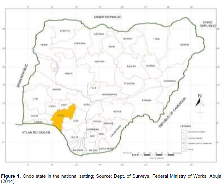
The study focuses on Akure city and its adjoining settlements that made Akure region as shown in Figures 2 and 3. Akure is a notable city in the South-western Nigeria which became the capital of Ondo State on February 3rd, 1976. It is located between Latitudes 7o 151 and 7o 171 North of the Equator and between Longitudes 5o 141 and 5o 151 East of the Greenwich Meridian. It is about 204 km east of Ibadan, capital of Oyo state; 168 km west of Benin City, capital of Edo state; 311 km north-east of Lagos; and 323 km south-west of Abuja, the Federal Capital Territory of Nigeria. Akure town spreads over an area of about 15,500 km2 in about 370 m above the sea level. Its population figure by the National Population Census (NPC, 1963) was just 71,106. With the influx of public servants into the town consequent upon state creation in 1976, the population rose to 239,124 and 360,268 in 1991 and 2006, respectively (NPC, 1991 and 2006) with a projection of 476,159 to year 2014 (on 3.18 annual growth rate) when this study was carried out (Figure 1).

The database
Data collection for this study was essentially through Aerial Imagery Overlay (AIO) with the aid of GIS, RS and personal observations. Other sources include government ministries and establishments for historical milieu of the area as well as base maps and population data used for the study. Internet facilities were equally explored for relevant information. The study area has a total (projected) population of 476,159 in 2014 with a total land expanse of 125,212 hectares. The main approach used in this study was mainly post-classification comparison analysis of satellite imageries of Akure obtained at three different decadal variations: 1985 to 1994, 1995 to 2004 and 2005 to 2014. This helps to show the direction and extent of growth in the study area from one period to the other. The land use for the study area is classified into four categories, which include: the built-up area (involving residential, commercial, industrial, recreational and educational land uses); thick vegetation (forested land areas); light vegetation (cultivated land areas), and the water bodies (Rivers, streams, etc).
Akure Urban sprawl and land use classifications-1986 to 2014
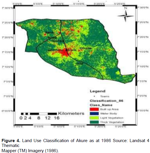
This study has discovered that lager proportion (80,796 ha.) of the study area were covered with thick vegetation as at 1986, which accounted for 64.53% of the land area while 37,977 hectares (30.33%) were cultivated and covered with light vegetation. Only about 5.1% was developed and used either for residential, commercial, recreational, industrial or educational purposes. This occupied just about 6,384 hectare (5.1%) land area while only about 56 hectares (0.04%) were covered by water. This situation expresses the low level of development as at 1986 with a small compact urban area as shown in Figure 4. In 2002, as revealed in Figure 5, the percentage of built-up area had increased from 5.1% (in 1986) to 16.63% (20,885 ha.). The cultivated land area (that is, light vegetation) also increased from 30.33 to 55.06% (68,940 ha.) while the area covered by thick vegetation reduced drastically from 64.53 to 26.34% (32,978 ha.). This shows there was much development and sprawling in cities and major towns in the region through building constructions and provision of public utilities through which much of the thick vegetation were depleted.

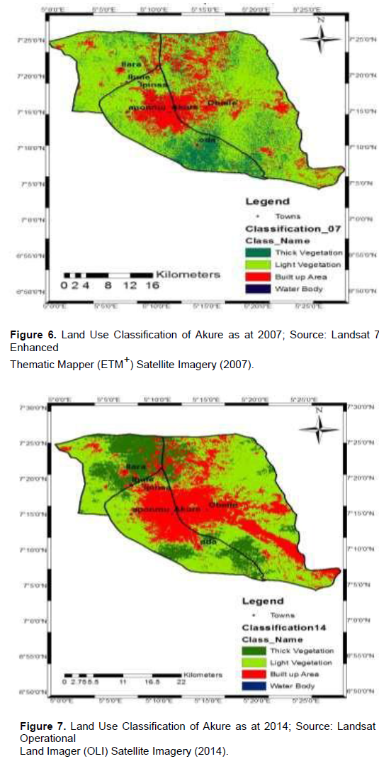
In 2007, the built-up area further increased to about 22,985 hectares (18.36%) as well as light vegetation cover to 82,415 hectares (65.82%). But land areas covered by thick vegetation and water body reduced to 19,002 hectares (15.18%) and 811 hectares (0.64%) respectively. This is well illustrated in Figure 6. While the land use for the built-up area continue to increase, those covered by thick and light vegetation as well as water bodies reduces in 2014. As revealed in the Figure 7, land use for built-up area had increased from 22,985 hectares (18.36%) in 2007 to 34,303 hectares (27.40%) in 2014 while light vegetation (the cultivated area) reduced from 82,415 hectares (65.82%) in 2007 to 72,675 hectares (57.51%) in 2014. The reason for this might be due to drastic reduction in number of farmers since majority of people working on the farms had been taken over by urbanization while some land areas meant for cultivation were acquired for provision of public utilities.
The inference that can be deduced from this analysis is the effect of the sprawling incidence on land cover as illustrated by the continuous expansion of the built-up area throughout the studying period. The drastic reduction in the percentage of thick vegetation shows there was a remarkable growth within the studying period. For instance, as shown in Table 1, the built-up area increased by 22.3% between 1986 and 2014 as well as light vegetation (that is, the cultivated land areas) by 27.71% while thick vegetation and water bodies reduced by 50.47 and 0.45%, respectively. This is the result of massive encroachment into the thick vegetation, rocky and undulating land areas through building construction, quarry, blasting and mining activities that were carried out in the region. It was equally discovered that economic situation in the state in the early 2000s encouraged individuals, government and various establishments to embark on various developments that lead to massive depletion of the vegetation. For example, in 2002 various projects were embarked upon consequent upon the discovery that the state falls within the mineral endowed region, which accounted for tremendous increase in the built-up areas in various parts of the state, including Akure region. Again, Akure gained much influx of people seeking greener pastures being the state capital while the discovery of bitumen in the state attracted much investor and other immigrants within the studying period. Its administrative status and concentration of several establishments like government ministries, housing estates, Ondo State Oil Producing Area Development Commission (OSOPADEC) secretariat, Federal University of Technology, Akure (FUTA) and various other institutions higher learning contributed to this attraction.
Pattern of land use land cover (LULC) changes in Akure region between 1986 and 2014
The LULC of Akure region was classified into four and examined in three decadal variations: 1986 to 2002, 2002 to 2007 and 2007 to 2014. The change detection analyses are presented in Table 1 and Figure 8. Results indicate that the percentage increase of built-up area, light vegetation (that is, cultivated land areas) and water body was higher between 1986 and 2002 than between 2002 and 2007. The percentage difference in built-up area was much higher between 2007 and 2014 while other land classifications have negative index.
This is due to the continuous depletion of vegetal cover occasioned by the rapid growth and development witnessed in the region in recent time.
Thus, thick and light vegetation were rapidly depleted and taken over by built-up land uses in the form of building constructions and provision of public utilities.
Analysis of urban built-up change detection and predictive modeling for future expansion
The spatial analysis of sprawling pattern observed in Akure region between 1985 and 2014 is expressed in Figures 4 to 7 and 9. The figures clearly express the direction and extent of growth in the period examined. For instance; as shown in Figure 9, the growth navigates towards the northern and the eastern parts of the region between 1985 and 2002 more than any other direction. These areas were earmarked for the construction of Government Residential Areas (GRAs) and most of government ministries. Besides, the area was the location of Ijapo estate, a notable residential estate in the Akure city that serves as object of attraction to much influx of people into the area. According to Oyinloye (2010), the construction of Ilesha-Akure-Owo express route which passes through the north-eastern part of the city was a notable factor that play prominent role of attracting people to the area. However, the direction of growth thereafter diffused to other directions, probably due to congestion in the north-eastern part and availability of cheap lands which might attract people to other parts of the city. The location of Federal University of Technology, Akure (FUTA) in the north-western part of the region has attracting influence on huge population of people into the area. Most staff of the institution and students live and build houses around the institution, thereby making the growth institutional attraction. Currently, the growth around this institution has almost captured Ipinsa and Ibule (the two nearest settlements) as high percentage of students of the institution find cheaper accommodation there as well as cheaper lands for staff and people from Akure to build residential buildings and hostel accommodation for students. These important developments that parade the city revealed significant difference in stages of expansion and land uses within the studying periods. These findings corroborate the work of Oyinloye (2010) and Balogun (2011) who observed significant difference in stages of development and growth in Akure since its inception as a state capital. Future expansion of the study area and possible change pattern in land use was modeled using Markov chain to guide policy makers in the management of land use activities in Akure and its environs. Adopting the 3.6% growth rate used in Oyinloye (2010) for Akure, future expansion of built-up area in the region for a period of 20 years (2014 to 2034) was predicted using Markov Chains modeling. This was estimated at 68,793.41 hectares as shown in Figure 9. It means by 2035, the built-up area would occupy about 53.41% land area of the region. By then, Akure would have become a full-grown conurbation and subsumed many of its adjoining communities.

SUMMARY OF FINDINGS AND POLICY IMPLICATION
The pattern of land use in the region elucidates an unguided expansion in the growth of Akure into the suburb. There were incompatible conversions of land use and undue encroachment into green areas in adjoining towns and villages. This is due to favorable economic situation in the state in the early year of the millennium. Between 2000 and 2005, for example, Akure gained much influx of people being the state capital and, most importantly, due to the discovery of bitumen in the state which attracted much investor and other immigrants in quest of greener pastures and job opportunities. The administrative status and concentration of establishments in the city were the key factors for this attraction. This prompted massive encroachment into thick vegetation which consequently leads to further developments and expansion of the city into various surrounding communities. Meanwhile, the regional setting of the area has naturally influenced the direction of the expansion. Based on major findings in the study, some policy recommendations were proffered to address salient issues. Firstly, the unguided nature of physical expansion and development with consequence effects on land use pattern in the study area needs quick attention. The check on this should commence with land acquisition and allocation procedures for various uses to guide against incompatibility errors and chaos. It is therefore recommended that ministries of Land and Survey, Housing and Urban Development who handles land issues in the state should employ resourceful control measures over private and public land uses through effective zoning strategy. In view of this, the Development Control Department (DCD) in the Ministry of Urban Development and Physical Planning should be reinforced with strong tools to carry out their duties, particularly in the area of effective monitoring for sustainable development.
The existing land use in the study area is more of residential, most of which are aged and dilapidated. In some parts of the city, especially at the urban core, there are series of ongoing redevelopment and building restructuring. In the course of changing some of these buildings, the usages are always at variance with compatibility standard. They constitute nuisance rather than complementing the planning and environmental standards. In this regard, it is recommended that adequate monitoring be made by DCD and other stakeholders in urban planning, right from plan approval stage to erection of structures to forestall such occurrences with a view to achieving a sustainable and virile livable environment. Besides, property rehabilitation strategy should be adopted on degraded landed properties rather than arbitrary removal and rambling replacements. This should involve improving the existing infrastructural facilities as well as providing new ones with a view to making their services functional and accessible to all. To reduce the level of encroachment into natural vegetation in the course of expansion, the study suggests vertical expansion in the form of storey buildings and high scrappers in place of lateral growth and expansion. It is believed that this will reduce the rate of land consumption and as well improve the structural quality and aesthetic value of the environment. The existing Master plan of Akure was produced in 1980 and has become inactive, old and superseded. There is need for a more comprehensive one as well as a Regional Plan to guide the development and spatial growth of the region. These plans are to be administered by a constituted board, which is to be saddled with responsibility to maintain an orderly and aesthetic environment in the region. The board is to be made responsible for the preparation and implementation of planning schemes as well as local, area and structural plans in conformity with the state and regional plans. This will go a long way to assist in regulating land use policies for sustainable development in the area.
The authors declare that there is no conflict of interests regarding the publication of this paper. The founding sponsors had no role in the design of the study as far as the collection, analyses, or interpretation of data is concern either in the writing of the manuscript or in the decision to publish the results.
REFERENCES
|
Akinbode OM, Eludoyin AO, Fashae OA (2007). Temperature and relative humidity distributions in a medium-size administrative town in South-western Nigeria. J. Environ. Manage. .
|
|
|
|
Angel S, Parent J, Civco DL, Blei AM (2010). Atlas of Urban Expansion, Cambridge MA: Lincoln Institute of Land Policy.
|
|
|
|
|
Arnfield AJ (2003). Two Decades of Urban Climate Research: A review of turbulence, exchange of energy and water, and the urban heat island in Inter. J. Climatol. 23:1-26.
Crossref
|
|
|
|
|
Balogun IA, Samakinwa EK (2015). Geospatial Assessment of Urban Expansion and Land Surface Temperature in Akure, Nigeria. 9th International Conference on Urban Climate jointly with 12th Symposium on the Urban Environment.
|
|
|
|
|
Balogun IA, Adeyewa DZ, Balogun AA, Morakinyo TE (2011). Analysis of Urban Expansion and Land Use Changes in Akure, Nigeria using RS and GIS techniques. J. Geogr. Reg. Plann. 4(9):533-541.
|
|
|
|
|
Bhatta B (2010). Analysis of Urban Growth and Sprawl from Remote Sensing Data.
Crossref
|
|
|
|
|
Chellasamy M, Chinnasamy U, Ramaswamy SK (2015). A neural-evidence pooling approach to predict urban sprawl using multi-temporal remote sensing data; Int. J. Geomantic Geosci. 5(3):459-473.
|
|
|
|
|
Houghton R (1994). The worldwide extent of land use change. Bioscience, pp. 305-313.
Crossref
|
|
|
|
|
Kufoniyi O (1998). Towards 3D GIS for Efficient Management of Urban Environment; Proceeding of the Technical Session of the 32nd AGM & Conference of the Nigerian Institution of Surveyors, Uyo; May 5-7.
|
|
|
|
|
Mirkatouli J, Hosseini A, Neshat A (2015). Analysis of land use and land cover spatial pattern based on Markov chains modeling. City, Territory and Architecture 2(4):1-9.
|
|
|
|
|
National Population Commission (NPC 1991 and 2006). National Population Census Reports.
|
|
|
|
|
Oduwaye L (2015). Urban Land Use Planning and Reconciliation. Inaugural Lecture Series 2015, University of Lagos, Nigeria.
|
|
|
|
|
Olofin EA (2012). The challenges of desertification and its effects on physical planning in Nigeria. A paper presented at the 43rd Annual Conference of the Nigerian Institute of Town Planners held at Women Development Centre, Abuja; November, 7-10.
|
|
|
|
|
Owoeye JO, Ibitoye OA (2016). Analysis of Akure Urban Land Use Change Detection from Remote Imagery Perspective. Urban Stud. Res. Vol. 2016, Article ID: 4673019: 1-9; Hindawi Publishing Corporation.
|
|
|
|
|
Oyinloye MA, Popoola OO (2015). The use of Geographic Information Systems (GIS) and Remote Sensing (RS) Techniques for Detecting Sub-Urban Growth in Federal University of Technology, Akure. Journal of Multidisciplinary Engineering Science and Technology 2(5):978-984.
|
|
|
|
|
Oyinloye MA (2010). Spatial Analysis of Urban Growth in Akure, Nigeria; Unpublished PhD Thesis, Federal University of Technology, Akure.
|
|
|
|
|
Rahman MT (2016). Detection of Land Use/Land Cover Changes and Urban Sprawl in Al-Khobar, Saudi Arabia: An Analysis of Multi-Temporal Remote Sensing Data. Int. J. Geo-information, Wolfgang Kainz publishers.
Crossref
|
|
|
|
|
Riebsame WE, Meyer WB, Turner BL (1994). Modeling Land-use and Cover as Part of Global Environmental Change. Climate Change 28(1-2):45-64.
Crossref
|
|
|
|
|
Rimal B (2013). Urbanization and the Decline of Agricultural Land in Pokhara Sub-metropolitan City, Nepal. J. Agricultural Sci. 5(1):54-65.
|
|
|
|
|
Sankhala S, Singh BK (2014). Evaluation of Urban Sprawl and Land Use Land Cover Change using Remote Sensing and GIS Techniques: A Case Study of Jaipur City, India. Int. J. Emerging Technol. Advanced Engineering 4(1).
|
|
|
|
|
Tofowomo A (2008). The Planning Implications of Urban Sprawl in Akure, 44th ISOCARP Congress 2008 United Nation Population Fund (UNPF, 1999). The State of World Population; United Nation Publication; New York: 76.
|
|
|
|
|
Vitousek PM (1992). Global environmental change: an introduction. Ann. Rev. Ecol. Syst. 23:1-14.
Crossref
|
|
|
|
|
Yohanna P, Gadiga BL, Mshelia AD (2015). Land Use/Land Cover Change Detection of Mubi Metropolis, Adamawa State, Nigeria, Sky J. Soil Sci. Environ. Manage. 4(6):70-78.
|
|


