ABSTRACT
Tropical landscapes are generally known to store much carbon in its varied ecosystems, but information required to prioritize and conserve areas with much soil carbon concentration is scanty. This study provides insight on the patterns of carbon storage and its dynamics in an extensive humid zone in SE Nigeria. Soil carbon data was downloaded from soil grids of 250 m carbon stocks for the first 30 cm of the soil profile and compared with the land use/cover, geology and digital elevation model of the region. Carbon estimates varied over the four epochs used and ranged from 29-177, 29-172, 12-172 and 4-177 tons/ha in 1992, 2001, 2010 and 2018, respectively. Even though land cover variation was quite distinct in the zone (between the northern zone with much cover and the southern zone with less), it was not seen as the major factor that influenced soil carbon in the zone. Much of the explanations on carbon concentration and variability were mainly from the geology of the zone which is categorized into six major classes. But three out of the categories were seen to dominate the carbon store: Ajali formation, Mamu formation and Nsukka formation. This exogenous factor (geology), which is not uniform, was seen as the major variable to consider in deciding areas that will be prioritized for carbon conservation in the zone. Proper land use strategies and policy frameworks that would help to maintain proper baselines and further enhance adequate carbon conservation were equally recommended.
Key words: Carbon management, conservation, land use change, modified ecosystems, prioritization, tropical.
Preserving ecosystems across the globe especially in the current Anthropocene era are rife with environmental challenges and are imminent concern. This need is increasingly urgent as much of the world’s landscapes have progressively been altered in various ways by human activities, with consequences such as habitat destruction, species extinction and modified biological communities (Pardo et al., 2018). This trend seems exacerbated by a growing human population whose demands and rising consumption demands lead to much pressure on ecosystems and furthermore contribute to the consequent degradation across the landscapes (Foley et al., 2005; Drescher et al., 2016). Though variable across spatial scales and biomes, this process of degradation has collectively affected much of the global land area (up to approximately 25%; FAO, 2011) and an undocumented array of their services and functions. Associated effects of such losses in ecosystem services especially carbon storage is really affected by the wide ranges of land use and its changes, since both the biodiversity and the soil of such zones (which act as carbon stores) become degraded.
Issues about carbon storage and its role in climate change mitigation are widely acknowledged and are of international concern (Sasaki and Putz, 2009; Mackey et al., 2013). Much of such efforts and inquiry on regulating climatic processes involving biogeochemical cycling and carbon storage have targeted tropical ecosystems due to their known capacity in achieving this (Saatchi et al., 2011; Lewis et al., 2013). Though tropical landscapes are at the epicentre of carbon sequestration, much of the strides on preserving and maximizing its carbon stores have been challenged by the ever-changing dynamics and modifications of the ecosystem. Indeed, tropical forest loss and degradation have grown in scale and magnitude over time and are considered a greater peril for global biodiversity than any other contemporary phenomenon (Pimm and Raven, 2000; Bradshaw et al., 2009). Such threats to tropical forest ecosystems have mainly emanated from activities in the region: agriculture and mining (Abood et al., 2015; Tyukavina et al., 2018), urbanization and other associated demands of increasing population in the region such as the need for more housing units and infrastructural developments. Though varied across scale within the region, these have contributed to altering the ecosystem such that as much as 500 million hectares of tropical forests are estimated to have been degraded as of 2009 (Asner et al., 2009). With an increase in degradation of landscape, ecosystem, habitat and land scales, tropical ecosystem services become more threatened and hence require concerted attention and management.
Efforts to conserve ecosystems have emphasized the use of protected areas and as much as about 15% of the earth’s land surface areas are set aside as protected areas to protect endemic species and facilitate ecological functions (Watson et al., 2014; Liu et al., 2020). Across the tropics, protected areas were established to promote ecosystem conservation (IUCN, 1994; Ezebilo, 2013) and in many parts of the tropical landscape such as in Nigeria, this has focused on the preservation of the biodiversity of the ecosystem, with little or no attention on soil conservation. Omitting such a vital segment in carbon sequestration initiatives is not ideal and should be redressed. This need for adjustment in conservation is deemed necessary since soil contains the largest pool of carbon in terrestrial ecosystems (Jobbagy and Jackson, 2000; Batjes, 2014); hence, by promoting its conservation and efficient use, more carbon could be sequestered. With such in mind, this work is focused on showing the soil carbon capacity of a wetland zone and the probable environmental factor or activity that defines its carbon concentration. Such initiative should help in achieving targeted carbon storage for the zone and the bulk of tropical landscapes where pressures and degradation that emanates from human encroachment and modifications are continually becoming a challenge.
Study area
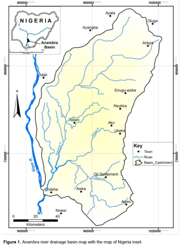
The study region Anambra River drainage basin- is a vast wetland zone in south eastern Nigeria (Figure 1). It lies within a weakly cretaceous tertiary and quaternary sedimentary rock formation that is found mostly on lowlands and a crest that is dominantly made up of false bedded sandstone. The region is located within the humid tropics where mean annual rainfall varies between 1500 to 22500 mm. Temperature condition of the area is high with mean annual temperature range of 27 to 28°C and a peak of about 35°C between February and April (Monuanu, 1975).
The south eastern zone where the study area is located is a dense population zone with a small land area compared to other parts of Nigeria where land is much more abundant. As a result, the zone is put to much use and become degraded; though with variations between the urban and rural areas. Much of the rural landscape is suitably used for agricultural activities over the years and is seen as the main cause of degradation. The zone is a river basin with a dendritic drainage pattern and is characterized by many tributaries that flow in a south eastern direction that drains into the River Niger. Within the river channels in the zone, artisanal fishing activities are practiced and form a major source of livelihood for many households. Forest cover loss and degradation in the zone are driven by underlying and proximate drivers of forest loss as seen in tropical landscapes and no known conventional conservation is practiced.
Data acquisition, analysis and processing
The Landsat data were acquired from the National Aeronautics and Space Administration https://earthexplorer.usgs.gov/ while landuse/land cover image with a spatial resolution of 300 meters was obtained from the European Space Agency (https://www.esa-landcover-cci.org/). The soil carbon data were downloaded from https://www.soilgrids.org/ for four epochs: 1992, 2001, 2010 and 2018. This was used to verify the patterns of change or dynamics of carbon storage over the region under review. Landuse data obtained from https://www.esa-landcover-cci.org/ were subset for the study area with 2018 being the base year. Dynamics of land use/cover for the four epochs: 1992, 2001, 2010 and 2018 were equally provided to ascertain the patterns of change and the contribution of land use in carbon store. The dataset was reclassified using the ArcGIS Reclassify tool. Digital elevation model (DEM) was equally downloaded from https://earthexplorer.usgs.gov/ while the geology map of the study area was developed from the geology map of the region.
Soil grid of 250 m carbon stocks for the first 30 cm of the soil profile as the reference values for calculation was used. First 30cm was used since it is where much carbon accumulation is found; hence it is a basic standard when assessing the changes in soil organic carbon in a location, a standard measurement in soil sampling for edaphic variables and is used extensively for such investigations (Marshall et al., 2012; Smith, 2014). To estimate the changes in land use, management and inputs as recommended by the carbon stocks, the carbon conversion coefficient for changes in Intergovernmental Panel Climate Change (IPCC) and the United Nations Convention to Combat Desertification (UNCCD) was adopted. However, spatially explicit information on management and carbon inputs is not available for most regions. As such, only land-use conversion coefficients were applied for estimating changes in carbon stocks (using land cover as a proxy for land use).
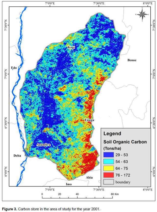
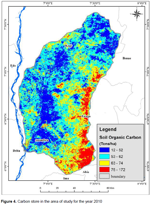
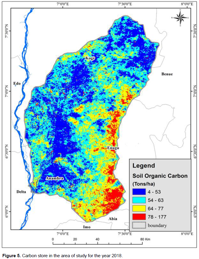
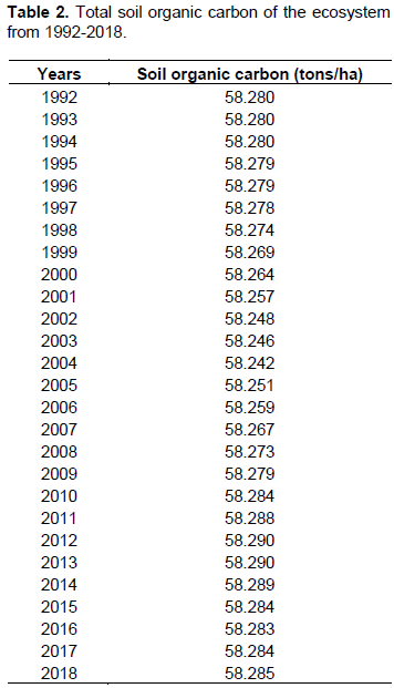
The area under study experienced modifications and changes over time, especially in its carbon storage (Figures 2 to 5) and then in land cover (Table 1). Soil carbon was found to vary in the area under study: 29-177, 29-172, 12-172 and 4-177 tons/ha in 1992, 2001, 2010 and 2018, respectively (Figures 2 to 5). Some part of the region had more carbon and others less, while in other cases, the variation was mostly from a temporal perspective in which case, it varied over the years. Total accumulated carbon over the zone reduced steadily from the initial year (1992) until 2004 and then increased afterwards (from 2005) until 2013; the remaining years (2014-2018) fluctuated in the accumulation (Figure 6). Though accumulated carbon varied across the years, the difference in the amount of carbon (tons) was quite minimal (Table 2); as the highest variation of 0.048 tons of carbon was seen between the 58.242 tons and 58.290 tons for 2004 and 2012/2013, respectively (Table 2). Such variations in carbon though slight, could be attributed to changes which would normally be seen in land use. Since dynamics in land use change easily impacts ecosystem services over short time scales (Li et al., 2013) and can directly lead to overall changes at regional scale (Vidal-Legaz et al., 2013) for ecosystem services such as carbon storage, guided use of ecosystems to prevent intense impacts are advocated. Carbon storage is indeed an ecosystem service that ecosystem degradation- through forest loss, disturbance and modification affects greatly (Igu and Marchant, 2016); however, such impacts have direct effects on the above ground carbon (AGC) (through biomass removal or reduction) than the soil carbon store (in comparison with the AGC) that are not easily discernible. Variations in decomposition rate of the litter (depending on land use and ecosystem) can equally contribute to the time lag involved in soil carbon store changes even when ecosystems become modified.
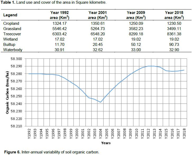
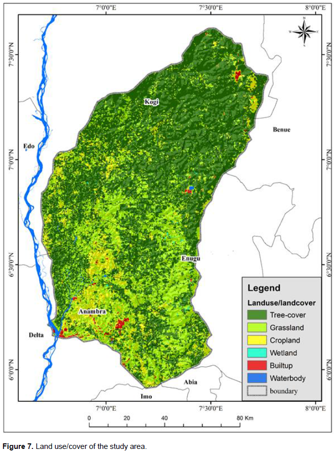
Land-use generally affects carbon storage in ecosystems but varies in its impacts according to the various categories of the land use or cover in each zone. Major categories as seen in the study region includes: tree cover, grassland, cropland, wetland, built up and water body (Figure 7). The extent of land area each of the land uses covered differed accordingly (Table 1). Areas categorized as natural landscapes: grassland, tree cover, wetland and water body, had higher extents of land in comparison with those that were already modified (cropland and built up zones). The later (modified zones) are expected to have lesser carbon stores than the former (natural zones) and since they are conversions from forest areas, they contribute to carbon emission for the area (Houghton et al., 2012; De Sy et al., 2019). While built up areas could be seen as an already transformed environment, agricultural landscapes on the other hand still retain ecological functions and are expected to store more carbon, depending on its intensity and system adopted. However, their contributions to soil carbon are minimal when compared to the natural landscapes that are the least modified and most likely to store carbon. Natural landscapes are less exposed and more likely to retain its carbon, especially the areas under tree cover and grassland which are characterized by biological activities and facilitating interactions.
Areas under natural landscapes, especially tree cover zones were not evenly distributed (Figure 7); thus showing the variations in land-use and human impact in the region. Vegetal covers were much concentrated in the northern than the southern zones which had much modified landscapes and were characterized by patches of forest covers. This pattern of forest cover distribution (less forest cover in the south and more in the northern part of the region) would be expected to dictate the soil carbon pool of the region, but it seemed minimal (comparing Figures 5 and 7). While forest cover amount and extent would no doubt affect the total soil carbon of the zone, the amount, rate and scale at which it happens are not easily discernible. Land cover in ecosystems is generally made up of varied species compositions with differing functional types, decomposing rates, soil fauna and microbes (De Deyn et al., 2008). These differing mechanisms which influence their carbon pools and dynamics do not easily change at very short time scales; hence, soil-carbon-environment interactions require more extensive, longer-term carbon studies and will form the basis for future studies for the region.
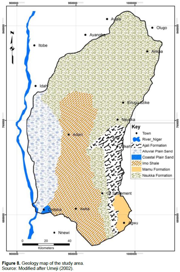
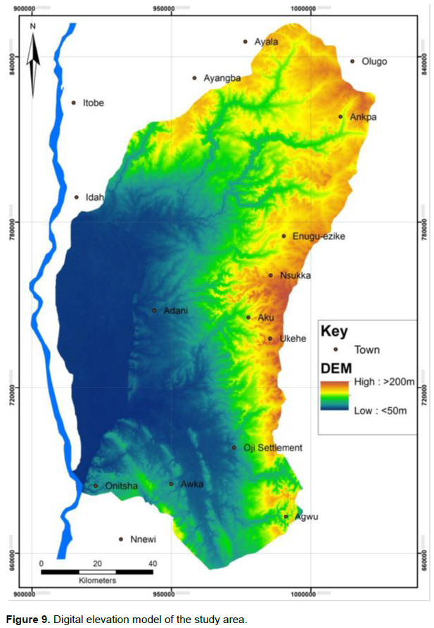
Much of the carbon was concentrated in particular areas of the study region, unlike in some other zones where it was more dispersed (Figures 2 to 5). Though affected by land cover and its dynamics, its concentration is however viewed to be determined by other exogenous factor(s); since such zones do not necessarily coincide with zones with much vegetal cover. Further comparisons of the geology (Figure 8) and digital elevation model (Figure 9) with the carbon map showed that carbon concentration of the region had more links with the geology of the area. Hence, though the geology of the area is broadly categorized into six (Figure 8), three geologic areas: Ajali formation, Mamu formation and Nsukka formation were where the carbon concentrated. Since the carbon was localized in such zones, efforts in promoting soil carbon storage for the region should be targeted there. Initial steps at achieving conservation across the Nigerian state were focused on biodiversity and to an extent, their soils. Areas that were mainly considered for such conservation efforts were mainly zones with much biodiversity and available land (Usman and Adefalu, 2010; Igu et al., 2017) and there were no records of conservation across geologic or soil zones for ensuring maximum enhancement of soil carbon storage. It has become imperative that such initiatives be prioritized following such guidelines especially as much land that would be ordinarily set aside for such purposes is shrinking in size and currently has competing interests. There is equally the need to continually conserve the carbon stores from going below the established baseline by engaging in proper land management schemes so that this important ecosystem service (carbon) will become better preserved and its benefits maximized across the region.
Managing ecosystems are essential for achieving prolonged ecosystem service use and efficiency. This is however confronted with a host of challenges in tropical landscapes such as Nigeria where land ownership and tenure issues are major points of concerns. Since much land is fragmented due to the multiple ownership structures and inheritance over the years, setting land aside for forest and soil conservation initiatives becomes more challenging; hence the need to equally maximize already existing reserves for such measures. Though available land seems to be dwindling due to the increasing pressures emanating from population growth such as development, need for more housing units (increased built up zones) and agriculture, governments should consider long term concerns of climate change and the need to sequester carbon in the ecosystems as pressing issues that need concerted attention. This may require making policies that would adjust how open and green spaces are gazetted, used and conserved to accommodate soil carbon storage initiatives. Particularly, this would require revisiting the land use act to enable government to set aside land that has higher carbon capacities (following environmental assessments) to be reserved. To make such strides to be feasible and effective, such reservations of land should not target extensive land areas in one location (as was the case in earlier days when much land were available), but instead sizeable portions of land should be gazetted in different locations. This will reduce the resistance by host communities as the parcels of land set aside in each location could be managed or absorbed in each zone. More so, adequate compensation should be given to communities or individuals whose land were taken over and where possible, involve them in the management of the land.
Ecosystems vary in their carbon store across spatial scales as seen in the Anambra drainage river basin. There is need to prioritize the zones with more stored carbon and conserve it through suitable ecosystem management strategies. Suitable policy frameworks that target land-use and cover changes are very desirable so that both the above ground carbon and its soil component will be better preserved and harnessed.
The authors have not declared any conflict of interests.
REFERENCES
|
Abood SA, Lee JSH, Burivalova Z, Garcia-Ulloa J, Koh LP (2015). Relative contributions of the logging, fiber, oil palm, and mining industries to forest loss in Indonesia. Conservation Letters 8(1):58-67.
Crossref
|
|
|
|
Asner GP, Rudel TK, Aide TM, Defries R, Emerson R (2009). A contemporary assessment of change in humid tropical forests. Conservation Biology 23(6):1386-1395.
Crossref
|
|
|
|
|
Batjes NH (2014). Total carbon and nitrogen in the soils of the world. European Journal of soil science 65(1):10-21.
Crossref
|
|
|
|
|
Bradshaw CJA, Sodhi NS, Brook BW (2009). Tropical turmoil - A biodiversity tragedy in progress. Frontiers of Ecology and Environment 7(2):79-87.
Crossref
|
|
|
|
|
De Deyn GB, Cornelissen JHC, Bardgett RD (2008). Plant functional traits and soil carbon sequestration in contrasting biomes. Ecology Letters 11(5):516-531.
Crossref
|
|
|
|
|
De Sy V, Herold M, Achard F, Avitabile V, Baccini A, Carter S, Clevers JGPW, Lindquist E, Pereira M Verchot L (2019). Tropical deforestation drivers and associated carbon emission factors derived from remote sensing data. Environmental Research Letters 14(9):094022.
Crossref
|
|
|
|
|
Drescher J, Rembold K, Allen K, Beckschäfer P, Buchor, D, Clough Y, Faust H, Fauzi AM, Gunawan D, Hertel D, Irawan B, Jaya INS, Klarner B, Kleinn C, Knohl A, Kotowska MM, Krashevska V, Krishna V, Leuschner C, Lorenz W, Meijide A, Melati D, Nomura M, Pérez-Cruzado C, Qaim M, Siregar IZ, Steinebach S, Tjoa A, Tscharntke T, Wick, B, Wiegand K, Kreft H, Scheu S (2016). Ecological and socio-economic functions across tropical land use systems after rainforest conversion. Philosophical Transactions of the Royal Society B 371:20150275.
Crossref
|
|
|
|
|
Ezebilo EE (2013). Nature conservation in Cross River National Park, South-East Nigeria: Promoting collaboration between local people Science, Ecosystem Services and Management 9(3):215-224.
Crossref
|
|
|
|
|
Food and Agriculture Organization (FAO) (2011). Assessing forest degradation: towards the development of globally applicable guidelines. Rome.
|
|
|
|
|
Foley JA, DeFries R, Asner GP, Barford C, Bonan G, Carpenter SR, Chapin FS, Coe MT, Daily GC, Gibbs HK, Helkowski JH (2005). Global consequences of land use. Science 309(5734):570-574.
Crossref
|
|
|
|
|
Houghton RA , House JI, Pongratz J, van der Werf GR, DeFries RS, Hansen MC, Le Quere C, Ramankutty N (2012). Carbon emissions from land use and land-cover change. Biogeosciences 9(12):5125-5142.
Crossref
|
|
|
|
|
Igu NI, Marchant R (2016). Aboveground carbon storage in a freshwater swamp forest ecosystem in the Niger Delta. Carbon Management 7(3-4):137-148.
Crossref
|
|
|
|
|
Igu NI, Nzoiwu CP, Anyaeze EU (2017) Biodiversity and Carbon Potentials of a Nigerian Forest Reserve: Insights from the Niger Basin. Journal of Environmental Protection 8(8):914-922.
Crossref
|
|
|
|
|
IUCN (1994). Guidelines for protected area management categories. IUCN, Gland and Cambridge.
|
|
|
|
|
Jobbagy EG, Jackson RB (2000). The vertical distribution of soil organic carbon and its relation to climate and vegetation. Ecological Applications 10(2):423-436.
Crossref
|
|
|
|
|
Lewis SL, Sonke B, Sunderland T, Begne SK, Lopez-Gonzalez G, van der Heijden GM, Phillips OL, Affum-Baffoe K, Baker TR, Banin L, Bastin JF (2013). Aboveground biomass and structure of 260 African tropical forests. Philosophical Transaction of the Royal Society B 368(20120295):1-14.
|
|
|
|
|
Li YF, Luo CY, Liu G, Ouyang ZY, Zheng H (2013). Effects of land use change on ecosystem services: A case study in Miyun reservoir watershed. Acta Ecologica Sinica 33(3):726-736.
Crossref
|
|
|
|
|
Liu X, Blackburn TM, Song T, Wang X, Huang C, Li Y (2020). Animal invaders threaten protected areas worldwide. Nature communications. http//doi.org/10.1038/s41467-020-16719-2.
Crossref
|
|
|
|
|
Mackey B, Prentice IC, Steffen W, House JI, Lindenmayer D, Keith H, Berry S (2013). Untangling the confusion around land carbon science and climate change mitigation policy. Nature Climate Change 3:552-557.
Crossref
|
|
|
|
|
Marshall AR, Willcock S, Platts PJ, Lovett JC, Balmford A, Burgess ND, Latham JE, Munishi PK, Salter R, Shirima DD, Lewis SL (2012). Measuring and modeling above-ground carbon and tree allometry along a tropical gradient. Biological Conservation 154:20-33.
Crossref
|
|
|
|
|
Monuanu PC (1975).Temperature and sunshine, in: Ofomata GEK(ed).Nigeria in Maps: Eastern states. Ethiope Publishing House Benin City.
|
|
|
|
|
Pardo LE, Roque FO, Campbell MJ, Younes N, Edwards W, Laurance WF (2018). Identifying critical limits in oil palm cover for the conservation of terrestrial mammals in Colombia. Biological Conservation 22:65-73.
Crossref
|
|
|
|
|
Pimm SL, Raven PR (2000). Biodiversity: Extinction by numbers. Nature 403:843-845.
Crossref
|
|
|
|
|
Saatchi SS, Harris NL, Brown S, Lefsky M, Mitchard ET, Salas W, Zutta BR, Buermann W, Lewis SL, Hagen S, Petrova S (2011). Benchmark map of forest carbon stocks in tropical regions across three continents. PNAS Early Edition.
Crossref
|
|
|
|
|
Sasaki N, Putz FE (2009). Critical need for new definitions of forest and forest degradation in global climate change agreements. Conservation Letters 2:226-232.
Crossref
|
|
|
|
|
Smith P (2014). Do grasslands act as a perpetual sink for carbon? Global Change Biology 20:2708-2711.
Crossref
|
|
|
|
|
Tyukavina A, Hansen MC, Potapov P, Parker D, Okpa C, Stehman SV, Kommareddy I, Turubanova S (2018). Congo basin forest loss dominated by increasing smallholder clearing. Science Advances 4 4(11):eaat2993.
Crossref
|
|
|
|
|
Usman BA, Adefalu LL (2010). Nigerian Forestry, Wildlife and Protected Areas: Status Report. Biodiversity 11:44-52.
Crossref
|
|
|
|
|
Vidal-Legaz B, Martinez-Fernandez J, Picon AS, Pugnaire FI (2013). Trade-offs between maintenance of ecosystem services and socio-economic development in rural mountainous communities in southern Spain: A dynamic simulation approach. Journal of Environmental Management 131(1):280-297.
Crossref
|
|
|
|
|
Watson JEM, Dudley N, Segan DB, Hockings M (2014). The performance and potential of protected areas. Nature 515(7525):67-73.
Crossref
|
|