The recurrent Cuvelai Basin floods are both a blessing and a curse. This article discusses the consequences that flooding has on rural livelihoods of the Cuvelai Basin in Northern Namibia. The combined flooding episodes in the last few years had a substantial impact on local residents and the Namibian economy, with estimated losses of approximately US$136.4 million (NAD1364 million) in direct damage and US$78.2 million (NAD780 million) in indirect losses. The consequences of flooding amounted to ~1% of the country’s 2009 Gross Domestic Product (GDP). Rural residents in the Cuvelai Basin live predominantly on small farm holdings (‘ekove’) allocated by local village leadership, and depend heavily on subsistence farming for their livelihoods. Since higher-lying ground with soil best suited for crop production becomes scarcer, residents are allocated land in low-lying areas which are smaller and more susceptible to floods. The destruction of crops, farm and grazing land, trees and livestock, by floods and similar disasters is of a huge concern. The study sought to assess the impacts of flooding that place residents at risk, and socio-economic conditions that lead to vulnerability. Qualitative data was collected using questionnaires for in-depth interviews and focus group discussions. The qualitative data was recoded and some of it coded in SPSS and STATISTICA to enable statistical analysis of the results. Qualitative responses are in turn partly used to substantiate the quantitative results. Residents of the Cuvelai Basin heavily rely on subsistence agriculture to sustain their livelihoods. The impacts of flooding on animal and plants are thus discussed.
Namibia has experienced recurrent [recorded] seasonal floods since 2008, destroying rural livelihoods for many communities dependent on subsistence agriculture. This article aims to outline the impacts of flooding on rural livelihoods. A livelihood “comprises the capabilities, assets (including both material and social resources) and activities required for a means of living. A livelihood is sustainable when it can cope with and recover from stresses and shocks, maintain or enhance its capabilities and assets, while not undermining the natural resource base” (Scoones, 1998:5). Many rural livelihoods are reliant to a considerable degree on the environment and the natural resource base (Scoones, 1998), and extreme climate events can impact severely on the agricultural sector (Saldaña-Zorrilla, 2007).
Impact of flooding on plant and crop communities
Some plants such as water lilies and rice grow well in an abundance of water. However, in drier areas such as fields or pastures, the presence of excessive amounts of water can cause the plants to become stressed and even die (Ransom, 2013). Apart from supporting life, as suggested by Huber et al. (2009), Van de Steeg and Blom (1998), Van Eck et al. (2004) and Voesenek et al. (2004), periodical flooding in floodplains can be considered as an environmental concern in the affected areas. The clogging of soil pores by water deprives roots of adequate oxygen subsequently leading to root and plant stress (Banach et al., 2009; Schipper et al., 2011). This also affects soil pH and nutrient base, influencing the distribution of plants across space (Beumer et al. 2008). With many of the Cuvelai residents being small scale subsistence farmers, with pearl millet (mahangu) being the main staple food in the basin, it is imperative that the impact of floods on plant and crop communities is understood and documented.
Excessive moisture in the soil decreases oxygen levels. This inhibits respiration (where the energy needed for cell division and subsequently plant growth is released from sugars) in the roots leading to the build-up of carbon dioxide, methane and nitrogen gases, subsequently causing the roots to suffocate and die. Toxic compounds such as ethanol and hydrogen sulphide can also build up in the soil and damage plants (Ransom, 2013).
Most of the crop failure cases hindering the productivity of the Cuvelai farmers revolve around waterlogging. Waterlogging (flooded/ponded/saturated soils), as referred to by Ransom (2013), affects a number of biological and chemical processes in plants and soils that can impact crop growth in both the short and long term. The primary consequence of waterlogging in crop plants is oxygen deprivation (anoxia) as excess water itself does not react chemically with the plant. Plants need oxygen for cell division which is central for growth of all multi-cellular organisms. Oxygen is also vital for the uptake and transport of nutrients by the plants. Because Oxygen diffuses much more slowly through undisturbed water than through a well-drained soil, its requirements by plants rapidly exceed what is available when soils are saturated.
The rate of oxygen depletion in saturated soil is further impacted by temperature and the rate of biological activity in the soil. DRFN (2008) predicts with a high degree of certainty that Namibia will become hotter in coming years, with a predicted increase in temperatures of between 1°C and 3.5°C in summer and 1°C to 4°C in winter in the period 2046 - 2065. DRFN (2008) asserts that maximum temperatures have been getting hotter over the past 40 years, as observed in the high frequency of days exceeding 35°C. Equally, the frequencies of days with temperatures below 5°C have been getting less, suggesting an overall warming. Faster oxygen depletion occurs when temperatures are higher and when soils are actively metabolizing organic matter.
Shifidi (2014) documented that water in the Cuvelai Basin can stagnate over major crop land for a period not exceeding three to six months, depending on the type of soil, slope gradient, as well as human influences. The longer that excessive water is present the more likely that damage to plants will be fatal. Generally, the oxygen level in a saturated soil reaches the point that is harmful to plant growth after about 48-96 h, as further confirmed by Ransom (2013). In an effort to survive, tissues growing under reduced oxygen levels use alternate metabolic pathways that produce by-products, some of which are toxic at elevated levels, a major setback for a community such as the Cuvelai Basin, which is heavily reliant on agriculture for survival.
Waterlogging can also indirectly impact crop growth by affecting the availability of nitrogen in the soil. Excessive water can leach nitrate nitrogen beyond the rooting zone of the developing plant, particularly in well-drained lighter textured soils. In heavier soils, nitrate nitrogen can be lost through denitrification. The amount of loss depends on the amount of nitrate in the soil. Some Cuvelai farmers can still get their hands on the NPK (Nitrogen, Phosphorus and Potassium) fertiliser. Adding NPK to the crops while they are still young as it is recorded by residents in some parts of the Cuvelai may overcome this consequence and assist in increasing crop yield.
Secondly, if leaves and stems are submerged, photosynthesis (absorption of energy by the plants from the sun to produce sugars) can be inhibited and plant growth can slow or even stop subsequently weakening and killing the plant. Thirdly, plants that are suffering from excessive-water stress are more prone to infection by disease-causing organisms such as fungi or insects as excessively wet soil tends to favour the growth of soil-microbes such as Fusarium spp., Phytophora spp. and Rhizoctonia solani, which can infect plant roots leading to diseases such as root and crown rot. Fourthly, the deposition of soil and rocks onto plants during flooding increases erosional friction subsequently exposing the plant roots and damage plants in the process as the protective layer is removed. This impact has a general tendency of extending through to the dry period even after the flood waters have receded, rendering the damaged plants more vulnerable to other stresses as plants with substantial root damage are more likely to be uprooted in windy conditions for instance (Cannell and Jackson, 1981), rendering a double blow to the farmers. Even once the flood waters recede it can take weeks for the soil to dry out with plants continuing to suffer damage in the meantime.
Crops can differ in their tolerance to waterlogging and the damage caused to plants by flooding depends on the type and growth stage of the plants. Established healthy plants have established good firmness and rigour and are thus generally more tolerant than young or very old plants which are less firm and less rigorous. Crops like small grains and corn tend to be more sensitive to waterlogging most especially when their growing point is still below the surface of the soil (before the 5-6 leaf stage). Germinating seeds/emerging seedlings are very sensitive to waterlogging as their level of metabolism is high, and can be killed if soils are saturated beyond 48 hours and soil temperatures exceed 65 oC, while late planted crops look much worse than earlier planted crops. Early planting of crops is one of the adaptive strategies that has been outlined by the Cuvelai residents to counteract the consequences of flooding on crop agriculture in the area.
Impact of flooding on livestock
Livestock are of utmost importance for status, income, livelihoods, as well as survival of populations and cultures that are relying on livestock production, including those of the rural Cuvelai. One of the fastest growing agricultural subsectors in developing countries with an agricultural GDP share of 33% (Thornton et al., 2006), and covering approximately 30% of the surface area of land (Steinfeld et al., 2006), livestock systems are a significant global asset with a value of at least US$1.4 trillion, employing 1.3 billion people and directly supporting the livelihoods of 600 million poor smallholder farmers in the developing world. Though there are very large differences between rich and poor countries, on a global scale, livestock products contribute 17% to kilocalorie consumption and 33% to protein consumption, making livestock a key component of world agriculture (Rosegrant et al., 2009). Thornton et al. (2006) support that livestock are important providers of nutrients and traction for growing crops in smallholder systems and livestock keeping is an important risk reduction strategy for vulnerable rural communities of the Cuvelai Basin.
Of all the factors influencing livestock production, climate and location are undoubtedly the most significant (Lammy et al., 2012). In fact, climate characteristics such as ambient temperature and rainfall patterns have a great influence on pasture, food resources availability cycle throughout the year, and types of disease and parasite outbreaks among animal populations.
Diseases that reduce production, productivity, and profitability are associated with the cost of their treatment, disruption of local markets, international trade, and exacerbate poverty on rural, local, and regional communities (Lammy et al., 2012). At the biological level, pathogens compete for the productive potential of animals and reduce the share that can be captured for human purposes (Food and Agriculture Organization - FAO, 2009; Rushton, 2009).
Description of the study area
The research was carried out in the Cuvelai Basin in Central Northern Namibia. The study area (Figure 1) was selected to concentrate on areas with defined drainage lines and where flooding is known to occur regularly. The Cuvelai Basin (also referred to as ‘the Basin’) is shared between two countries, almost split in half by Angola and Namibia. Most of the floods occurring in the Southern part of the Basin which lies in Namibia are generated high up in the catchment in the Angolan highlands.
Determining the spatial extent of the sampling transects
To determine the sample of the study area, three sampling transects were overlaid on the study site at equal intervals as shown in Figure 2. The greatest north-south extent of the study site is in its most eastern direction, and is roughly 96 km which is divided between three selected transects. This means that each of the three transects would cover 32 km in a north-south direction. The horizontal extent is limited to the boundaries of the study site in each transect in both west and east directions. The first centerline of the first transect (Transect 1), is located 16 km from the northern-most boundary of the study site (half of 32 km) and from Angola. The centerlines of all three transects were then placed 30 km from each other. The centerlines were transformed into 20 km wide polygons by buffering the centerlines by 10 km on each side. This means that the transects are each 20 km wide, and are roughly 8 km apart, with the first transect being roughly 4 km from the starting point and from Angola. The area with the least defined drainage was discarded from the sample as shown in Figure 2.

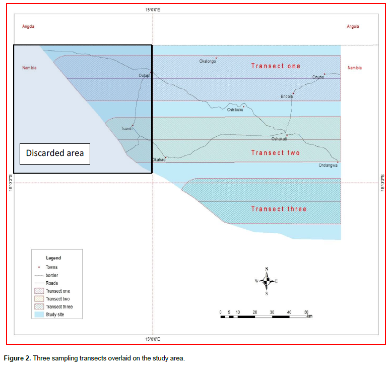
The entire study site is then covered by the transects stretching in the east-west direction and sloping down the southern direction, giving all areas in the study site equal chances of being involved in the study. This also takes into consideration the north-south or upstream-downstream slope gradient, as well as the population distribution of the basin.
Determining the sample of the study
Selection of the sample was largely informed by the pilot study conducted a few months before the main study commenced. Households and interviewees (Figures 3 and 4) were selected depended on the researcher’s expert judgment and primarily on the advice from the local TAs.


Interviewees
The interview process started off with having to travel to the sample villages and identify the residence of the village headmen. A consultation with the headmen was held and the purpose of the visit outlined. After having an understanding of the project, the headmen gave consent to give an account of their villages with regards to flood disasters, how they cope with floods, and how the villages’ residents are impacted upon. The worst and least affected residents’ households were identified by the headmen from the village maps and their vulnerability status classified from least to worst affected as supported by purposive sampling methods. For purposes of better navigation and to ensure trust in the researcher by local residents, the village headmen allocated an assistant to the research team.
After completing interviews for Transect 3, and other areas in Transect 1, it was noted that the responses from the residents were becoming overly homogenous. Due to increasing sample homogeneity and community leaders’ advice, the total number of households visited was reduced to 314 from 495. As can be seen in Figures 4 and 5, the distribution of respondents per transect were approximately equal with Transect 1 housing 32% of the respondents (99), while Transect 2 and 3 contributed 27% (86) and 41% (129) respectively. Transect 3 had the most respondents. The interview process started with Transect 3, then Transect 1, before finally moving to Transect 2. As the data collection proceeded in each transect, the sample homogeneity increased, explaining the gradual decrease in sample size over time and space.

The majority of the selected respondents interviewed, fell in the category of ‘flood-affected residents’ that were adversely affected by flooding in the past (237 out of 314). This observed homogeneity of the dataset is also shown in Figure 6 with flood-affected residents making up 76% (n = 237) of the total respondents (n = 314), while community leaders (n = 42) and non-affected local residents (n = 11) make up a cumulative 24%.
All interviewees provided informed consent to participate in the study in accordance with the headman of the village or area and the local TA. All interviews were anonymous and no sensitive information regarding the respondent was transcribed. The data was captured in excel, coded in Statistical Package for Social Sciences (SPSS) and analysed in both SPSS and STATISTICA.
Cuvelai livelihoods flood cycle-dependent
Survey results indicate that there are a great number of people that prefer floods since there are long term benefits associated with flood conditions. Scaled down, this is most especially true in very dry areas with low rainfall. Respondents from Transect 3 associated flood waters by definition with increased food production. It is essential to note that the rainfall decreases southwards of the basin. In years with normal rainfall and greatly reduced stream density and as according to local residents, such areas can go for long periods of time without water. The dry situation is reportedly worsened when there is no influx of waters from elsewhere to fill the normal water channels that have to reach crop fields or to recharge temporary water ponds. Flood disasters are regarded as ‘a temporary inconvenience’ in this area. Though floods may cause many inconveniences, the local communities have reported that they consider that long term benefits of flooding outweigh the short term inconvenience of flooding. Some of the benefits of floods include increased harvest and livestock productivity for drier places, recharge of sub-surface water reserves and aquifers, as well as increased fishing activities and income.
Results revealed that this is most especially true in very dry areas with low rainfall, especially areas covered by Transect 3. Other researchers as documented in Chapter 1 and Chapter 3 have also recognized the importance of floods to the livelihoods of those residing in the affected areas. Tanner (2005) stated that annual floodwaters of the Nile and other large rivers deposit fertile soils along the surrounding floodplains, which are used extensively for agriculture. Nguyen and James (2013) have also found that residents of the Mekong River Delta have intentionally settled in these low lying areas due to good fertile soils and optimum conditions for agricultural purposes. Mendelsohn (2013) documented that the main and most general benefit is the coming and going of floods that had made life in the Cuvelai possible and suitable for human habitation and subsequent agricultural productivity.
Increased agricultural productivity
Even though more than 90% of the respondents have experienced some level of crop damage since the onset of flood events (Figure 8), there are households (5% of respondents) in some areas of Transect 3 that have recorded an increase in crop productivity (Figure 7). In drier parts of the Basin especially where waters would not reach under normal circumstances, floods are reportedly preferred over ‘no flood situations’, and any long period standing source of surface water, often rare, is considered a valuable asset to the livelihoods of the people residing there. The Cuvelai residents also report that only when floods are big enough to reach areas at the lower extents of the basin, can residents and livestock temporarily get unlimited access to surface water. Similarly, in north-west Europe as Verhoeven and Setter (2010) documents, in the long history of floodplain use for agriculture, the floodplain systems remained intact as wetlands with regular flooding until major engineering operations started about 200 years ago to protect crop fields and human settlements from flooding, processes with altered the ecosystem, hindered the free flow of natural flood waters, and thus reduced agricultural productivity. Due to lower rainfall, lower stream density and subsequent poor soil fertility reported by the residents of Transect 3, dry areas are dominated by seasonal grasses and few shrubs, of which grasses are a primary house construction material. The higher parts of the floodplains are highly suitable for growing crops, while the lower parts are wetter but are often suitable for grazing (Verhoeven and Setter 2010). Some residents of Transect 3, being located lower at the basin, have associated high flood waters with blossoming grasses for thatching and for livestock consumption as well as increased catfish for food. After the floods recede, the soil is left moist and plants can grow for a number of months until it eventually dries out again. Some of this water is trapped in ponds for future use by the residents and their livestock after the flood event.

According to Verhoeven and Setter (2010), humans have been cultivating land for food production and initially, human settlements primarily occurred in fertile areas along rivers. As Verhoeven and Setter (2010), Tanner (2005) and Mendelsohn (2013) indicate, due to their fertile soils as a result of regular sediment deposition during flood events. These riverine wetlands have been recognized as valuable land areas for food and fodder production since the early beginning of agricultural activities.
Recharge of sub-surface water reserves and aquifers
The Cuvelai River system is an ephemeral system and residents have no access to this water throughout the year. Some residents interviewed also have no access to piped water, and as a result some of the residents depend on surface water during floods and ground water during dry seasons. Groundwater or rainwater that has seeped into the ground where it is stored in water bearing layers known as aquifers for many years is usually valuable in places where no other water suitable for human consumption is available. Responding in favour of floods, some residents felt long standing waters are good as they recharge the underground water sources, from which they can tap during hydrological drought conditions. As also documented in Mendelsohn (2013), groundwater is also used to supplement supplies obtained from other sources. Notably, water is pumped from the Kunene River into a vast network of pipelines across much of the northern half of the Basin. Other surface water in this area is available from iishana and pans after good rains have fallen, and from small freshwater ponds known as eendobe. This surface water is often contaminated by livestock, however, and not well-suited for human use. Cleaner water is also widely available in small quantities from shallow hand-dug wells called omifima.
Fishing
Fishing is one of the main sources of income in the Cuvelai Basin reported by the local residents. Fish are caught and sold to the local markets as well as neighbouring Angola and as far as the capital city, Windhoek. Most fish are also dried and reserved for drier seasons, and it is a common delicacy in northern Namibia.
In the distant past, and as the residents report, fishing was more confined to iishana such as the traditional seasonal and highly irregular 130 km wide iishana channel network amalgamation which occurs during times of wide floods. In the recent flood years however, as described by local communities, the fishing area has increased in geographic extent and widened to even include fields and homes within the flood extent zones. While this observation may be true in some areas irrespective of transect, it may not hold as such in others. Though the extent of floods and that of fishing may have increased, the people have started constructing houses and commencing with agricultural activities directly in or closer to old, dry and seemingly safe looking iishana, thus increasing vulnerability of residents to floods. Certain residents willingly reside in flood prone areas in search for better agricultural purposes and income from selling agricultural produce and fish. Lack of land use planning at village level further exacerbates the resident’s vulnerability to floods.
Welcomme et al. (2006) wrote that river floodplains provide a major benefit to river fisheries. Many river-dwelling fish species spawn in aquatic vegetation on floodplains and the fish larvae feed on the floodplains, so that fisheries can be strongly enhanced by water management that allows river flooding on a regular basis. The common fish species associated with the Cuvelai waters are the Catfish (Clarias spp. e.g Clarias gariepinus), Straight- fin Barb (Barbus paludinosus), as well as the Three-spot Tilapia (Oreochromis andersonii) (Cunningham et al., 1992). The catfish are associated mainly with flood events and seasons of particularly good flows. This particular fish is suspected by some to have come with flood waters from Angola, subsequently colonising the lower parts of the Basin. It has also been suspected by some to aestivate during the dry season and resume from dormancy again when sufficient waters flow in the area. The nature surrounding the Catfish is still a matter of debate, and it is beyond the scope of this article.
Livelihood destruction
As outlined in Min et al. (2011) and Pall et al. (2011), an abundance of water in some place may be a direct consequence or a direct driver of shortage of water elsewhere. Though floods may be necessary for livelihoods to flourish in some parts of the Cuvelai, floods can cause huge destruction to the livelihoods of the local residents in other parts and depending on the times disasters may strike. Following are some of the negative impacts of flooding at household level as outlined by the local communities.
Destruction to crops and reduced harvest
The perception of residents of ‘standing water’ (indicated in 7) is mostly linked with destruction of crops and immovable property. Results suggested that majority of the population endured the negative impact of crop damage with reduced harvest as compared to years of relatively good rains. The damage was mostly a result of waterlogging and leaching, and direct washing away of crops, consequences also reported by Ndjodhi (2011).
This is also expressed in Figure 8 with 94% of the population (n=249) having had to endure the negative impact of crop damage with reduced harvest as compared to years of relatively good rains. A small percentage (< 1%) did not manage to produce any crop during the consecutive flood years due to heavy flooding which caused extensive remodelling and altering of the fields rendering them unsuitable for cultivation. Many fields were either completely submerged by floods or were highly waterlogged which made ploughing impossible or extremely difficult. According to FAO (2014), waterlogged soils deter agriculture, even in parts of the world where an excess of water is not usually thought of as a problem. Waterlogging has been reported by FA0 (2014) to interfere with agriculture in Egypt where about one-third of the Nile Delta has a water table only 80 centimetres below the surface. Soil can also become degraded through loss of nutrients - chiefly nitrogen, phosphorus, and potassium - if these are not replenished to maintain soil fertility (FA0 2014). Besides being lost through erosion, nutrients are also depleted by the crops themselves, particularly if the same crops are grown on the same land year after year (FAO 2014; Ransom, 2013; Cannell and Jackson, 1981).

Even though most of the mahangu crops (pearl millet) withstood direct washing away by floods, the resultant grains and flour was reportedly unpleasant to consume due to reported discolouration, unusual yet potent odour and loss of taste. The fields with ‘less firm’ crops suffered the most consequences, with all crops washed away altogether with the flood waters into the iishana. Grain crops such as millet, dry legumes such as beans, as well as corn have also been reported by Ransom (2013) as some of the most waterlog intolerant crops. Apart from sorghum, these are also the main crops heavily planted by many residents in Cuvelai, with mahangu planted in all cultivating subsistence fields.
The residents alleged that during flood years most fields undergo extensive flood damage and destruction of crops. According to the information provided only a comparatively small number of less than ten percent did not experience any crop damage associated with floods as the flood impact was very minimal to non-existent in these areas (Figure 8). In 2009 and 2011 especially as the survey gathered, there were homesteads that failed to harvest even a single grain from the fields, a situation that created increased dependency on Government and donor food relief as it can be inferred from respondents’ answers. The impact of floods on crops is also substantiated by Huber et al. (2009), Van de Steeg and Blom (1998), Van Eck et al. (2004), Voesenek et al. (2004), Banach et al. (2009), Schipper et al. (2011), Ransom (2013), Cannell and Jackson (1981) and Beumer et al. (2008).
Even though during flood years most fields undergo extensive flood damage and destruction of crops, according to the information provided there was a comparatively small number of less than ten percent did not experience any crop damage associated with floods as the flood impact was very minimal to non-existent in these areas (Figure 8). This condition is also reflected in Verhoeven and Setter (2010) when they documented that in the long history of floodplain use for agriculture, the floodplain systems of north-west Europe remained intact as wetlands with regular flooding and agricultural productivity has been high.
Determining reduction in crop productivity
Also referred to as ‘agricultural output’, crop yield is defined as a measurement (metric tons or kilograms per hectare) of the amount of a particular crop harvested (often cereal, grains, or legumes) per unit area of land (Investopedia, 2013). Alternatively, the actual seed generation from a particular crop can also directly be used as a measure (ratio or percentage) of crop yield (Investopedia 2013). In order to estimate crop agricultural output, the amount of produce gained from a sample area is calculated.
The most common grain measuring instrument used by rural small scale farmers to measure their annual agricultural production in the Cuvelai is the 20 L equivalent barrel called ‘olata’. To calculate crop productivity there is a need to convert litres (a measure of volume with L3 dimensions) to kilograms which is a measure of mass (M). An equivalent of 1 L is roughly 0.96 kg of grain. Hence 20 L will yield an equivalent of 19.2 kg. The size of a barrel itself does not determine the final conversion value, but it also depends on what is being measured, in this case, grains. This means that converting a 20 L barrel of oil and a 20 L barrel of mahangu grains to units of mass will yield totally different results. For minerals especially, temperature and pressure as well as levels of hydrocarbons among other many factors must be taken into consideration. Investopedia (2013) as described above, documents some of these conversions, but to a somewhat less explicit extent. While details of conversion are not directly relevant for this article, it is also important for the reader not to be caught up in these conversions or to miss the purpose of this section.
An average of the number of barrels produced per year during the past four flood years (2007, 2008, 2009 and 2011) was calculated and compared to the average quantity of barrels produced during years of no floods. In some cases, this is a generalization. The amount of mahangu yielded during flood years was then subtracted from the amount of mahangu harvested during non-flood years (Equation 1). The resultant difference was then used as a measure of reduction or increment in mahangu productivity. A percentage of the difference was then used and computed into 8 classes shown in Figure 9.
Crop productivity (%) = Preflood crop yield - Post flood crop yield (1)
As a result of crop damage by floods, a cumulative of close to 70% of the population (n=128) reported (Figure 9) a heavy reduction in crop productivity of 60 to 100%. This did not only indicate an obvious state of food shortages in the area, but also particularly a huge economic setback to the small-holding farms who sell their surplus crops to secure school funding for children and other basic necessities at household level.
Determining loss of crop income
An insight into the proportion of communal residents (n=20) who sell part of their remaining crops for income (9%) is given in Figure 10. Much of the crop produce, not sold, is bartered between those that were not heavily affected by floods, and flood-affected residents in exchange for fish which is in turn a scarce commodity in areas where floods do not often reach. Flooded residents have plenty of fish and very limited or no crop yield, while non-flooded residents may have good crop yield and less to no fish, creating a need for this kind of bartering trade among the residents.

According to Kukulka (1993), barter is nothing new, and people have always traded goods and services instead of buying the things they need. With high taxes and ever growing inflation rates, it becomes relevant to reconsider and encourage barter trade initiatives at community level such as the Cuvelai. Though most of the community barter systems recorded are operating in developed countries such as the Americas as documented by Silver (1993) are usually sophisticated, it becomes questionable whether such systems can be simplified and adapted to local conditions not only in the Cuvelai but in Namibia communal areas, as a measure of alleviating poverty which remains an indirect contributor towards socio-economic vulnerability.
Not many residents have indicated their status as trading cash crops (n=20) as shown in Figure 10. According to the Communal Land Reform Act (CLRA) (Act No. 5 of 2002), utilizing communal land for commercial purposes, which is initially reserved for the poor, is not encouraged (Government of Namibia 2002). Another reason could be parasitism, when a resident resumes a state of absolute lack of income with an intention or hope of receive assistance from government in the future. Thus, due to Government dependency driven reasons and possible expectations of residents to receive food assistance if their harvest is poor however, the figures of cash crops may be greatly underestimated.
View the average income loss due to flooding events as shown in Figure 11. Reduction in crop productivity has led to affected residents losing between 70 to 100% of their sales since the onset of the recent flood cycle years. As gathered from the local respondents, mahangu sales are usually made using an average price measure of NAD70.00 per 20 L (19.2 kg) bucket. However, with different high consumer demand rates in certain parts and seller desperation in other parts, the prices reportedly vary greatly across the area, costing as high as NAD90.00 in some and as low as NAD50.00 in others. To determine the average loss in income due to flooding, the average amount of mahangu sold pre-floods is subtracted from the average amount of mahangu sold during the cycle of flood years using Equation 2. The difference, shown in Figure 11 as percentage for the sake of generalization is then taken as an indicator of crop income loss.
Income loss(%)= Preflood yield income - Post flood yield income (2)

Destruction to indigenous fruit trees
Since the recent flood years as per comments made by local residents during interviews, communities have observed a striking reduction in local fruit bearing trees such as various berries and marula trees in the area which are usually central to the livelihoods of some residents in the basin. In fact, some residents indicated they would not relocate to other areas as expressed through comments such as, ‘this is where we get our money from, if we relocate it will take longer for indigenous trees to grow there again’, or ‘since floods, we no longer sell ‘ombike’ [a traditional brandy made of local fruit]. Berry trees in the most waterlogged soils especially begin to wilt and eventually die or reduce in productivity as reported by the residents. This has had a major setback on the economy of the local people, as it had subsequently led to reduced production of the indigenous products for commercial purposes. The impacts of soil waterlog has been discussed by Ransom (1993).
The destruction of local fruit trees by strong floods is a major concern outlined by local residents during the interview. One of the main sources of income to the local people of the Cuvelai lies in the production of natural local brandies called omagongo (produced from marula fruit (Sclerocarya birrea), also known as mukumbi by the Vhavenda people of Limpopo) and ombike (produced from Bird plum (Berchemia discolour) berries locally known as eembe).
Marula tree (Sclerocarya birrea): Impact to local livelihoods
According to Mutshinyalo and Tshisevhe (2003) and Shackleton (2002), widespread in Africa from Ethiopia in the north to KwaZulu-Natal in the south and in most of the arid and semi-arid areas of sub-Saharan Africa, the marula tree is one of the plants that played a role in feeding people in ancient times. In Namibia some people use the wood for sledges. Boats are also made from the trunk. Red-brown dye can be produced from the fresh skin of the bark and is used to colour traditional beads and attires. The gum, which is rich in tannin, is mixed with soot and used as ink (Mutshinyalo and Tshisevhe, 2003). The frequently community dominant tree is referred by Shackleton (2002) as a keystone species (that has a disproportionately large effect on its environment) in community ecology and productivity. Because of its widespread occurrence and use, the marula has frequently been identified as a desirable species to support development of rural enterprises based on the fruit, brandy or nuts, and therefore a species for potential domestication. Though the marula grows very fast (1.5 m per year) (Mutshinyalo and Tshisevhe, 2003) [in favourable conditions], recurrent uprooting and impact by local flooding in the Cuvelai has made the recovery rate some-what stagnant, an impact that has been felt by those heavily dependent on this plant for income generation.
Bird plum (Berchemia discolour): Impact to local livelihoods
Distilled from the boiled local fruit which are soaked and let to ferment for days, ombike is sold to fellow local residents, local markets, and during community events and gatherings. For a higher profit, the brandy is transported to as far as Windhoek (the capital city) and other urban centres where it is usually in a much high demand, or as far as Angola. The drink is also served in some restaurants that specialise in traditional foods mostly located in major urban centres such as Windhoek. The market for ombike is actually higher than that of omagongo, but both contribute to the economy of the local people.
Often found on clays, and stream valley and riverine soils, bird plum berries are quite nutritious as the fruit is very high in ascorbic acid and sugar (FAO, 2014). The yellow-brown wood is one of the hardest in East and Central Africa, making excellent furniture, pestles, ladders, poles and is used in general construction (FAO, 2014; Musaba and Sheehama, 2002). Just like the marula, roots produce a black colour, the wood brown, and the bark red used to dye various traditional attires and equipment such as baskets. Bird plum is especially susceptible to waterlog and Forest Research Strategy for Namibia 2011-2015 by MAWF (2011) has recommended that monitoring of episodic events such as floods is necessary for increased harvest of bird plum.
Impact on livestock
As revealed by Thornton et al. (2006), livestock are of utmost importance for status, income, livelihoods, as well as survival of populations and cultures that are relying on livestock production. Lammy et al. (2012) have also outlined that climate, which largely influences types of disease and parasite outbreaks, is one of the major factors affecting livestock production.
Several cases (n=87) of unhealthy livestock were reported by local residents, with 68% of the households confirming cases of affected livestock (Figure 12). The most affected animals were goats, sheep and calves. Relatively, mature cattle were not as badly affected by flooding as small stock and calves. Animal ill-health conditions and symptoms such as ‘splitting hooves’ and rashes dominated the list of negative impacts that flooding had on the communities. In many cases, no veterinary services visited the affected areas due to inaccessibility of the roads leading to the areas and cut-off by floods. Many cases also went unreported to veterinary services for investigations as it is revealed by the local residents. Lammy et al. (2012) validates that diseases are among the most severe factors that impact livestock production and productivity, adding that animal diseases have a great global impact on food supply, trade and commerce, as well as human health, further exacerbating poverty on rural communities.

The study revealed that in Ombuga areas such as Etope, deadly symptoms were experienced in cattle. Affected animals were reported to have succumbed to death within a day of showing symptoms of, in addition to the ones mentioned above, weak joints and inability to give birth unassisted. Some residents reported to have lost close to 100 herds of cattle over the recent flood years.
Navarre (2006) has outlined various diseases that can be contracted by livestock post-flood events such as: Blackleg (which can occur in cattle, sheep and goats following floods, particularly in areas where grass is short and animals are grazing close to the ground. The signs vary with the particular disease, but acute death is common with all. This disease is easily prevented with an inexpensive vaccine, and surviving animals should be removed from areas where these diseases have occurred); Botulism (a toxin that can proliferate in decaying animal carcasses or vegetables and can contaminate water supplies. Birds and horses are particularly susceptible. This disease causes paralysis, which shows up first as weakness with difficulty eating and swallowing. Treatment is supportive care, and prevention is avoiding exposure to stagnant water and decaying carcasses and vegetables); Foot rot (animals standing in mud or water for prolonged periods of time may develop foot rot (cattle, sheep, goats) or thrush (horses). Animals should be removed from the muddy, wet environment, the hooves and soft tissue should be cleaned, and dead tissue should be trimmed away. Antibiotics may be needed in severe cases).
Though all of the above diseases mentioned by Navarre (2006) have characteristics similar to the ones described by the local residents of the Cuvelai, no veterinary services were ever called to investigate most of these cases. This article does not have scientific evidence or proof to link the symptoms narrated by the Cuvelai rural residents with those documented by Navarre (2006).
Apart from disease outbreaks, many animals succumbed to death as a result of hunger as much of the grazing land became submerged subsequently reducing grazing and habitat land, a situation that has led to overcrowding, starvation and unhealthy conditions such as diseases and then death. According to the residents, a greater percentage of animals had also died as a direct result of drowning. Affected mostly were small animals like goats. As explained by residents, herders relocated their cattle to better land in time in 2011 as opposed to flood instances in 2008 and 2009. As a result, cattle were not as a badly affected as other animals in the 2011 floods.
According to Navarre (2006), cattle, goats, horses, pigs and sheep surviving disasters are vulnerable to several diseases, including infectious diseases and toxicities. Animals surviving disasters, especially animals that have been evacuated or displaced and relocated, are under a tremendous amount of stress. They also may be commingled with other livestock. This combination of stress and exposure to new diseases can lead to outbreaks of respiratory and gastrointestinal diseases. Abrupt feed changes are also stressful and can cause significant disease and even death (Navarre 2006), so feed changes should be minimized as much as possible.
Livestock productivity
In Northern Namibia, the local population is primarily dependent on livestock for the production of meat, fat, milk, and hides as well as for services such as transportation, ploughing, and provision of fertilizers. Cattle are also seen as a symbol of an individual’s wealth and status in the community.
Flooding affects livestock productivity in many ways, and local residents have identified some of the associated negative impacts. Some of examples of negative con-sequences associated with livestock reduction include, reduced trampling of livestock on field and reduced fertilisers. Figure 13 shows the reduction of goats and sheep due to flooding. The figure shows that 67% of the population had lost between 60 and 100% of their herds of livestock, and only 2% of the local residents had reported no impact of flooding on their livestock and no losses thereof.
Determining livestock productivity
The steps used to determine reduction in livestock productivity are similar to those used in determining crop productivity, and it is unique to this article. An average number of cattle that died due to floods per year during the recent flood years was calculated and compared to the average number of cattle a farmer had during years of no floods. In some cases, this is a generalization. A cumulative amount of cattle deaths during flood years was then subtracted from the total cattle pre-floods. The resultant difference was then used as a measure of reduction or increment in cattle productivity. A percentage of the difference (Equation 3) was then used and computed into 7 classes shown in Figure 13. In the Cuvelai, livestock may be viewed in the same light as cash, and a cattle kraal in the same light as a bank account. There are thus some residents (n=24) who decided not to disclose the number of livestock lost to a mere stranger. For interest sake, questions of how many heads of cattle lost to floods and how many are left were often reversed back by interviewees, asking how much money the researcher has in their bank account. Productivity of livestock given here would therefore be an understatement of true events.
Livestock productivity (%) = pre flood livestock yield - post flood livestock yield (3)
Loss of human life
In many situations residents had direct contact with sick animals not only during assistance with cattle labour or in assisting weak animals to keep balance (okutumba), but also via direct consumption and handling of carcasses. The residents further revealed that, many of the traits of ill-health depicted by animals had spread to the local human population. Some of those illnesses included, wounds on the body, rashes, and splits in-between fingers which lead to bleeding in some cases and itchiness. Navarre (2006) mentioned earlier that if un-inoculated animals are not handled properly, the diseases may be transferable from livestock to persons in contact with the animal or their carcases.
The residents also informed the researcher that no medical assistance was sought by affected persons. This was due in large part, to clinics and health facilities being inaccessible and mobile clinics were either limited or not in close proximity to respective affected communities.


