ABSTRACT
History has countless evidence of civilization growing by the water-fronts. Rivers like Indus, Nile, Tigris, etc., are known for the human settlements which developed here. The river fronts today are degrading due to uncalled interventions and human ignorance towards their ecology. The trend in case of many contemporary urban rivers, surrounded by a modern society and a predominantly technology driven economy, is no different. The dying Dravayawati River in Jaipur, India, in last two decades of urban sprawl in Jaipur has been a witness to occurrence of a significantly large number of industries of different types along its urban edge. These economic growth poles have attracted population, leading to unplanned development and encroachments. Disposal of domestic and industrial waste directly into the river, lack of seasonal rainfall, encroachment on river bed, etc., have contributed adversely to the natural environment and quality of living in the urban city. Strategies to save and improve upon the quality of natural and built environment along these river-fronts are essential for an optimal ecological balance. This would also make them socially cohesive and of help to create breathing spaces amidst the dense built fabric of the urban centre. Planning interventions and design solutions, as proposed, can be relied upon as immediate and long term measures to revitalize the river and further enhance its character, locally and regionally.
Key words: Water-front, urban growth, environmental degradation, revitalization, social cohesiveness.
Jaipur, a historic planned city is presently administrative capital of Rajasthan state in north-west frontier of India. Its physical and demographic growth has been significantly higher than other cities in the state. The rapid urbanization here, owes foremost to its strategic location from the national capital, Delhi. As a part of the DMIC project and also being a known tourist destination the city is a prominent socio-economic center of the state. All these have boosted the urban growth of the city over the years (Jaipur Development Authority, JDA, 2011). This rapid urbanization at times may have adverse impact on the natural resources, geophysical characteristics, environment, etc., of the city. Dravayawati River in Jaipur in its role of natural drainage has been the lifeline of the city in the historic times. The Dravayawati River is a concurrent case of natural features under threat of negative impacts of urban growth.
Dravayawati River was a perennial source of water to the planned walled city of Jaipur. Due to irregular seasonal rainfall, it was realized that growing demand of water supply could not be fulfilled by the river. Later on, due to industrialization, with all the industries started to locate near the river; it became the medium to carry waste outside the city (Kathleen et al., 2013).
Due to establishment of the aforementioned economic growth poles, the city saw increase in population, reason primarily been migration of people from near-by towns in search of better economic opportunities. Vacant lands around these growth poles were encroached by these populations leading to informal development, further adding to disposal of domestic waste into the river. Hence, Dravayawati River over the years has transformed into a waste disposing nala (drain) (Government of India, Ministry of Water Resources: Central Ground Water Board, 2013), reasons being rapid urbanization, urban sprawl and sporadic industrial activity along the river.
Recently, the degrading river has gained attention due to its impact on the immediate context. The lifeline of the city has seen environmental degradation and has lost its aesthetics due to the aforementioned reasons. JDA has taken the initiative in collaboration with Tata Projects in cleaning and cleansing of the river. Tata Projects has proposed a plan for establishment of eleven sewage treatment plants along the river, by identifying the locations of source of waste generation and disposal into the river. Further, the following phase of the proposal includes re-development of land to be acquired along the river after channelization of river bed.
Objective of the study
The paper focuses on studying the present impact of the degrading river on the context and based on the findings form a development plan proposal for revitalization of the river and re-development of the land along the river-front after the land reclamation process.
Methodology adopted
In order to fulfill the objectives of this study, the methodology that has been adopted, includes understanding of water-front development principles and strategies from literature provided by various authors and researchers. Also, undergoing a primary physical survey in co-relation with secondary data (collected from stakeholders) to analyze the present scenario of the river and its immediate land-use.
Water-fronts by common knowledge are areas where water comes in contact with land. It is where the built environment interacts with the natural environment. The characteristics of a water-front development can be described in environmental, economic and social aspects. To understand the aspects to be integrated for a water-front development, the earlier works of similar nature have been looked in.
Water-fronts contribute as an essential factor towards environment, as it consists of natural habitat, which needs to be conserved; also, major economic activities takes place at water-fronts which generate revenue at local and regional level; and provides for interaction among people.
Wrenn (1983) has characterized the water-fronts as zones of interaction between urban development and the water and a water-front area is considered to be a unique and irreplaceable resource where it interfaces between land, water, air, sun and productive plants. Also, L. Zang (2002), states that water-fronts are characterized as a place, integrating land with water and having a natural attraction to people. In fact, water edges are most attractive water features for human settlement and in most countries the land in front of water developed earlier than the island areas.
As water-fronts are limited in nature, proposing such development needs to function in a successful and sustainable manner which can only be achieved through public participation, providing essential infrastructure services, appropriate planning and design interventions, and should benefit all stakeholders.
H. Bertsch (2008) recommended several principles that must be adopted while preparing development plans for water-fronts, and they are as follows:
(1) Accessibility: Water-fronts should have accessibility to both vehicles and pedestrians, in order to make it more usable to all.
(2) Integrated: Integration of heritage, culture and existing developments into the new development.
(3) Sharing benefits: The overall benefit of the development should be accommodated among the public and private agencies equally, as to maintain a balance.
(4) Stakeholder participation: Stakeholder participation includes, government institutions, developers, environment agencies, community level organizations, and most important the public, all need to work together to make water-front development successful.
(5) Construction phase: Project phasing is an important element of the project implementation plan, as it delineates all the works priority wise.
As discussed, the aforementioned aspects need to be integrated to make a water front-development successful. The development, however, should also be sustainable in nature, as it maintains an optimum balance between nature and built environment for the future development. R. Bruttomesso (2006) formulated various principles to ensure development of water-front projects with a sustainable approach. The selected approaches adopted in the redevelopment proposal in concurrent case are: (1) secure the quality of water and the environment; (2) integration of water-fronts with the existing urban fabric; (3) public accessibility is a prerequisite; (4) public participation is an element of sustainability; (5) planning and execution in public and private partnership.
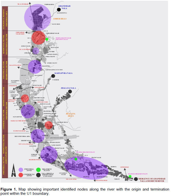
The degraded Dravayawati River, commonly regarded as Amanishah Nala (drain) today, originates in north of Jaipur city in Amer Hills at Akadadoonga and runs down south through entire Jaipur to merge with the Dhund River which originates from the Jhalana Hills. The study area comprises of the entire length of 47.5 km of Dravayawati River lying within the U1 boundary. Two major tributaries that merge into Amanishah Nala (drain) are Kharatapura Nala (drain) (Ganda Nala (drain)) which originates at C-Scheme and Jhalana Nala (drain) that originates at Jhalana Hills and merges with the main stream at Mansarovar and Sitapura industrial areas, respectively. The main stream and all tributaries carry industrial and domestic waste from their surroundings (Jaipur Development Authority, JDA, 2011) (Figure 1).

The adjacent land-use/cover of the Nala (drain) can be described as: first five kilometers as ravine steep slope, next twenty kilometers as residential land-use with mixed densities where maximum encroachments exists, next five kilometers passes through the Sanganer industrial area where effluents are disposed into the Nala (drain), also encroachments are observed with illegal agricultural practices going on and the last seventeen and a half kilometers of mixed-use density with Sitapura industrial area, followed by agricultural lands (Tata Projects Limited, 2015).
The prime factor for the degradation of the river is the setting up of industrial areas on the edge of the river that dispose untreated wastes, also on the basis of physical survey more than fifty sites have been identified as source of sewage disposal into the Nala (drain), mainly being unplanned and encroached residential areas. However, there are two existing sewerage treatment plants located on the banks of the Nala (drain); Swarnajayanti Nagar STP and Delawas STP, though each are incapable to handle the existing treatment demand (Jaipur Development Authority, JDA, 2011). For proposing planning interventions and planned development, the whole stretch of 47.5 km of the river has been divided into ten sub-zones, based on their different characteristics. Also, to understand the impact of the Nala (drain) on the neighboring context, a distance of 500 m to 1.5 km has been taken as the buffer zone in this study.
CHARACTERISTICS OF SUB-ZONES
The following are the sub-divided zones of the Amanishah Nala (drain).
Sub-zone 1: Growth pole
This zone consists of Vishwakarma industrial area, an economic growth pole in the region. Huge amount of industrial and domestic untreated waste is disposed in the Nala (drain) from this zone. Encroachments and unplanned residential settlements of industrial workers in search of better quality of life are common along Nala (drain).
Sub-zone 2: Mixed land-use
The zone is a mixture of different landuses; Vidhyadhar Nagar has planned development, Ram Nagar has slums and encroachments, Kishan Bagh has industrial land use and institutional land use is predominant at Mundru. A few parcels of unplanned development along the Nala (drain) are observed in this zone.
Sub-zone 3: Industrial and public utility
The zone consists of one of the oldest industrial areas; Hasanpura. Located near the Jaipur Railway Station, this area has attracted planned and un-planned residential and commercial development over the years. Waste generated from this region is again disposed into the nala (drain).
Sub-zone 4: High density residential sector along army cantonment
High density residential development and few slums have been observed along the edge of the Nala (drain) with a high population density. Untreated waste from this residential sector is directly disposed into the Nala (drain).
Sub-zone 5: High investment and development zone
This zone consists of New Aatish Market; a major commercial node which is connected by the Jaipur metro, serving the region with high population accessibility and usage. This gives the zone a high potential for investment and development in the future planning (Figure 2).
Sub-zone 6: Eco-sensitive sites
Large parcels of vacant land have been observed which needs to be preserved to maintain the balance between
built and natural environment. One of the parcels is owned by the agricultural government authorities and other one exists in a high density residential sector.
Sub-zone 7: Industrial and public utility
Mansarovar industrial zone that is a tertiary based sector and existence of the Jaipur international airport serves as a high economic interacting zone. Also, huge parcels of vacant land are observed on the banks of Nala (drain) with medium density residential plots along the periphery which needs to be preserved.
Sub-zone 8: Mixed land-use
The zone consists of the Sanganer industrial area which is a textile based local economy with high density residential land-use. Also, traces of slums and unplanned development are observed in this zone. Commercial land-use at edges of major roads and large parcels of vacant land are observed in the zone. High amount of waste is disposed from the local informal industries.
Sub-zone 9: Growth pole
Sitapura industrial area exists in this zone with few traces of institutional and residential development. All the waste generated from this zone is disposed into the Nala (drain).
Sub-zone 10: Undeveloped agricultural land
The last zone in the U1 boundary is primarily of agricultural fields, which needs to be preserved from
future conversion into other land-uses.
DATA COLLECTION AND ANALYSIS
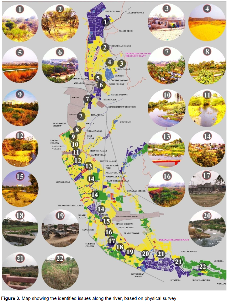
Primary survey and secondary data collection have been done to identify issues related to degradation of river, its impact on the adjoining areas, their land-use, ecology, etc. For the primary data, reconnaissance survey was conducted to visually analyze the present impact of the river and based on this study, Strengths, Weaknesses, Opportunities and Threats (SWOT) analysis was concluded. Whereas, for secondary data, population, density, quantity of sewerage disposal, DLC and market rates and land ownership were collected from respective authorities for the further analysis.
Primary data analysis
The primary data analysis consists of SWOT analysis which is on the basis of reconnaissance survey conducted, described briefly.
Strengths
Physical attributes: Amanishah nala (drain) runs along the whole Jaipur, starting from the north east in the hills of Amer to the south west of the city, where it merges with the Dhund River. It serves as a natural drainage to the city’s storm and waste water system.
Strong urban form with distinct character: The nala (drain) runs through areas of different typologies of landuse, ranging from industrial to commercial, including residential sector, each unique in itself. Each sector can be served respectively in terms of activities that can be provided for both social and economic development.
Impact of ongoing city development: Upcoming of various infrastructure and utility projects, has affected and modified the development pattern around the nala (drain) and has improved the quality of living conditions in some sectors (Figure 3).
\
Weaknesses
Limited accessibility: The Nala (drain) is not accessible at the edges, but is only visible through various culverts/bridges crossing the Nala (drain). Hence, hindering the physical contact of the population with it.
Blighted physical conditions: The river is degrading due to the ignorance of human interventions. Some of its parts are dried up, whereas rests are either disposed with waste or are encroached.
Stigma for present context-land value: Due to degrading conditions, land values along the Nala (drain) is diminishing and is affecting the nearby context. Measures should be adopted to limit this effect on the land value by the Nala (drain).
Context turns their back to the Nala (drain): No present development faces the Nala (drain), due to its negative aspects, resulting in losing as an identity to the city.
Opportunities
Can be established as engine of sustainable growth: The
development of Nala (drain) will not only cater to the sustainability of the environment but also with introduction of appropriate activities, can generate employment opportunities for the migrating population and will help in improving the socio-economic status.
Re-claim brown field development: This development can be taken up as an option for land acquirement and can be put to a better use which is more socio-economic viable.
Wider access to better environment quality: The intention should be to promote better quality urban environment through conservation, enhancement, regeneration and reduction of pollution and congestion around the river-front.
Threats
Environment degradation: If re-development of the Nala (drain) is ignored, it will proceed further towards environment degradation and will not promote better environment quality for the context.
Encroachments: Unsystematic development can take place in form of encroachments by which will lead to further degradation of the Nala (drain), as more untreated waste will be disposed and the proposed treatment plants will be in-effective.
Secondary data analysis
The data collected from various authorities were analyzed and the conclusion ID briefly described as the following.
Population growth rate: From the Jaipur’s MDP 2025, the population within the U1 boundary would be 75.9 lakhs by 2045 with an annual growth rate of 2% (Jaipur Development Authority, JDA, 2011).
Population density: The current average density within the U1 boundary is 128.97 pph (Jaipur Development Authority, JDA, 2011).
Sewerage disposal: The net catchment area within the U1 is 184 sqkm and the sewerage generated by the population is 275 MLD (current data). Hence, deducting the waste treatment by the present functioning STP’s, the total untreated waste is 150 MLD (Tata Projects Limited, 2015).
Land values: Form the analysis of DLC and market rates along the nala (drain), the average ratio of both comes to be 1.65, with is lower than the ideal ratio of 1.8 to 2.2.
Based on the analysis of the aforementioned data, the city is witnessing growth in population with a medium based spatial density pattern; however, presently the amount of waste generated and disposed by the various city activities is not treated to the standards, resulting in unpleasant aesthetics and environmental degradation. Also, the context is affected by this impact, as it degrades the neighboring land values; concluded from the secondary data, the DLC/Market Rate Ratio is lower than the ideal ratio range.
Jaipur is witnessing rapid urbanization over the last few decades affecting the spatial growth pattern and the natural environment. One of the impacts is on the natural urban river which has been degrading over the years due to human ignorance, which actually needs attention on priority. Appropriate planning and design initiatives for the river front development, thus need to be taken promptly to ensure better quality of life and a healthy environment. Also, it is important to control the future development along the river-front to protect it from excessive development practices. The aim to conserve the only existing urban river, Dravayawati, can be accomplished by integrating activities that promotes human cohesiveness and engagement. To achieve the aforementioned, specific land-use and activities need to be integrated to make the river-front accessible to the public.
The recommendations for revitalization of Amanishah Nala (drain), based on the earlier discussed analysis, are divided into planning and design prospects. The planning prospects consists of land-use proposal for the vacant parcels, development control guidelines for existing developments and various infrastructure based developments like transportation, urban housing, etc., whereas the design prospects consists of designing of Nala (drain) channels based on different sections and neighboring land-uses to promote public cohesiveness.
Planning prospects
The planning interventions for the Amanishah Nala (drain) are described as follows:
(1) To identify catchment areas and propose water shed development.
(2) To regulate urban land-use change appropriately to minimize negative impact of the present as well as the future development.
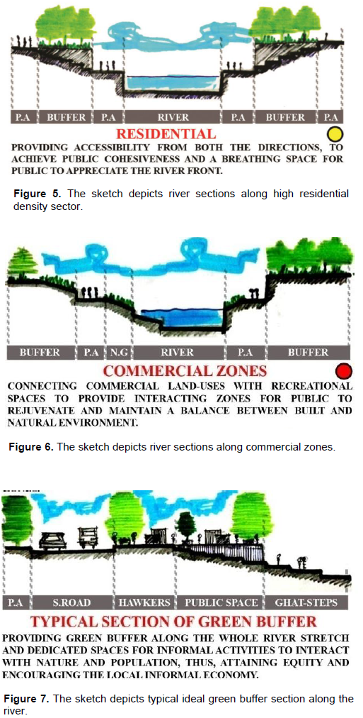
(3) Providing urban housing solutions to existing slums and encroachments to achieve equity and enhance their quality of life (Figures 4 to 7).
(4) Conserving the eco-sensitive sites and integrate them with the river front development, thus enhancing the environment quality.
(5) Proposing commercial land-use with public/semi- public function with integration of private sector; to generate funds for the future operations and maintenance of the river-front development.
Design prospects
The design interventions for the Amanishah Nala (drain) are described as the following.
(1) Identify different river sections along the stretch and design appropriately, to limit further urban growth and enhance its accessibility; to achieve the goal of social cohesiveness.
(2) Integrating land-uses with open spaces to promote public accessibility.
(3) Identifying in-efficient culverts/bridges and restructuring them to meet the present and future traffic demand to avoid traffic congestions and bottle necks.
(4)Designing of publicl andscaped walk ways,urban furniture and infrastructure services to improve the social aspect of the future development.
Besides the planning and design recommendation for the river front project, it is also essential to address the planning issues that may arise for post development of the project. The future impact can lead to issues related to sudden demographics growth, haphazard economic growth, public interest related, slum formations, etc., hence altering the land-use which may not be according to ones planned by the authorities. Hence, there’s a need to formulate strict land-use regulations along the river stretch in order to tackle the aforementioned issues.
To regulate the aforementioned land-use change various strategies that can be adopted, which are:
(1) Land taxation: Higher property taxes to be incurred by the property owners, where land-use change is to be restricted and providing subsidies where land density is to be increased. Also, specifying the maximum FAR to control the density pattern of the area.
(2) Agricultural land parcels: Sites undergoing illegal agricultural practices need to be protected and consumed with sustainability and initiatives to be taken up to increase the land productivity.
(3) Community participation: The governance and management of the project can be executed at ward level with the respective population, under local formulated public committees that will be in direct contact with the monitoring of the overall development of the project.
The authors have not declared any conflicts of interest.
REFERENCES
|
Bertsch H (2008). The key elements to successful waterfront design. Real Estate Weekly.
|
|
|
|
Brultomesso R (2006). Waterfront development: A strategic choice for cities on water. Waterfront Development Forum: China Maritime (02"d March 2006). Hong Kong.
|
|
|
|
Government of India, Ministry of Water Resources: Central Ground Water Board (2013). Ground Water Information- Jaipur District, Rajasthan.
|
|
|
|
JDA (Jaipur Development Authority)(2011). Jaipur Master Development Plan-2025.
|
|
|
|
Kathleen R, Michael R, Kimberly G (2013). Water Scarcity in Jaipur, Rajasthan, India. Jaipur: Jal Bhagirathi Foundation.
|
|
|
|
Tata Projects Limited (2015). Detailed Project Report, Amanishah Nala (drain). Jaipur, Rajasthan.
|
|
|
|
Tata Projects Limited (2015). Detailed Project Report, Amanishah Nala (drain). Jaipur, Rajasthan.
|
|
|
|
Wrenn DM (1983). Urban watereont development. Washington, D.C: The Urban Land Institute.
|
|
|
|
Zhang L (2002). An evaluation an urban riverfront park, Riverfront Park, Spokane, Washington- Experience and lessons for designer. Unpublished master thesis. Washington State University.
|


 \
\