Full Length Research Paper

ABSTRACT
The impact of climate change on the incidence of soil erosion was examined in the Benin-Owena River Basin, Southwestern Nigeria. Climate change was indexed by rainfall and temperature. Information was obtained on these parameters from 1960-2010 for some selected stations in the basin. Similarly, data on erosion control measures were obtained in the basin from 1990-2010. The results obtained showed gradual increase in temperature, vis-à-vis a fluctuating trend in rainfall. Erosion control measures increased in the drainage basin due to the uncertainties observed in the climatic indices. Intensive sporadic rainfall and increasing temperatures occasioned intensified control measures adopted in the basin. It is concluded that climate change has impacted erosional activities in the basin. It is recommended that more structures should be developed to curb the menace of erosion in the basin.
Key words: Climate change, drainage basin, erosion, rainfall, temperature.
INTRODUCTION
Climate change has been defined as a change in the state of the climate that can be identified (e.g. by using statistical tests) by changes in the mean and/or the variability of its properties, and that persists for an extended period typically decades or longer (IPCC, 2007). Recent evidence and predictions have indicated that climate changes are accelerating and will lead to wide-ranging shifts in climate variables. Specifically, in 2007, the Fourth Assessment Report of the Intergovernmental Panel on Climate Change (IPCC) effectively put to rest many of the debates surrounding the science of climate change, rendering -evidence solid enough to impel action. It found that warming of the climate system was ‘unequivocal’ and that a number of attendant effects were already observable (Pender, 2008). The range of effects has included a warming of sea water temperature that has given signs such as the collapse of ice shelves in Antarctica, propelling a dangerous sea level rise that now threatens many settlements along the coastal environments, along with pollution and other anthropogenic or human-related- drivers, the very existence of coral reef ecosystems around the world. These changes to our natural world gravely threaten the health and quality of life of many environments that inhabit our coastal zones. Global average temperature is projected to increase to as high as 1.4-5.8oC in the next century compared with temperature levels in the 1990s (Sygna, 2005). The case of overflowing/increase in the volume of the River Niger and the consequent flooding with its attendant ecological disasters in the third week of September, 2012 is very fresh in mind. Various communities along the Niger River valley in Nigeria were affected, with destruction of settlements, farmlands, communication networks, livestock, lives and properties. This has been described as extreme weather events occasioned by global warming.
Soil erosion is the gradual destruction of the earth through the action of water and other agencies that weaken the earth surface over a period of time. It has been referred to as the detachment and removal of the topsoil either partially or completely. Soil erosion is the physical process by which soil particles are detached and removed from the ground surface by water and wind (Segura et al., 2014). Soil erosion threatens soil fertility due to nutrient and organic matter loss while also decreasing water quality through increased turbidity (Brown and Froemke, 2012). There are two types of soil erosion: geological (occurring where there is flow of energy and matter on the earth surface), and accelerated (resulting from man’s activities). Accelerated soil erosion often results in the physical loss of the soil constituents, leading to severe economic loss arising from reduced crop yield or total crop failure (Faniran and Ojo, 1980; Odemerho and Onokerhoraye, 1994). Also, accelerated soil erosion can lead to loss of land due to gullying, pollution of streams, seas, silting up of lakes and damage to canals and irrigation works. Gullying is the most serious type of accelerated erosion. It has been more recently compounded by the current sporadic rainfall due to global warming. Apart from other factors of the nature of soil and land surfaces, vegetation, agriculture, mining, construction works, climate has recently become a very potent force leading to global concern. In a related work, Nearing et al. (2004) observed that global warming is expected to lead to a more vigorous hydrological cycle including more total rainfall and more frequent high intensity rainfall events. Rainfall amounts and intensities increased on average in the United States during the 20th century and according to climate change models, they are expected to continue to increase in the 21st century.
These rainfall changes, along with expected changes in temperature, solar radiation and atmospheric CO2 concentrations will have significant impacts on soil erosion rates. According to them, rainfall erosivity levels may be on the rise across much of the United States when rainfall amounts increase, erosion and runoff will increase at an even greater rate: the ratio of erosion increase to annual rainfall increase is on the order of 1:7. Even in cases where annual rainfall would decrease, system feedbacks related to biomass production could lead to greater susceptibility of soil to erode. They hold that erosivity results calculated from the Canadian Centre for climate modeling and analysis model also showed an increase in erosivity across northern United States including New England and Southern Canada. The Canadian Centre model result also indicated a reduction in erosivity across much of southern plains, from Texas to Nebraska. Results of the computation using annual precipitation indicated changes in parts of southern United States tending towards lower erosivity. Soil erosion may be expected to change in response to changes in climate for a variety of reasons, the most direct of which is the change in erosive power of rainfall (Nearing, 2001; Pruski and Nearing, 2002a). According to Segura et al. (2014), rainfall runfall erosivity (R) is one key climate factor that controls water erosion. They identified the watersheds that are vulnerable to future climate change in terms of soil erosion potential. Their results show that mean decadal rainfall runoff erosivity (R) value would increase with time according to all nine climatic projections considered between 1970-2090. These trends vary widely spatially. In general, catchments in the northeastern and northwestern United States characterized by a strong increasing trends in R in midwestern and southwestern United States are either weak or inconsistent among the nine climatic projections. The northeastern and northwestern United States will likely experience a significant increase in annual variability in R in extreme events (that is increase).
According to Olaniran (2011), three types of actions have been suggested to address the problem of climate change: these include mitigation, adaptation, and resilience. Mitigation involves efforts to prevent climate change. Mitigation activities can be divided into two parts: conservation and development and deployment of alternative energy sources. Each of these has two principal components which are technology and behavior change. Adaptation deals with responses to climate-related disasters that are not prevented by mitigation efforts while resilience is the characteristic needed in individuals, communities, nations and the world, to prepare for disasters to reduce the suffering and loss they bring and to rebound in positive ways. Effective structural planning could be an important tool and potent mitigation and adaptation strategy to address the problem that may arise from the effects of climate change and erosion. The relationship of climate change and soil erosion is the focus of the current investigation.
Study area
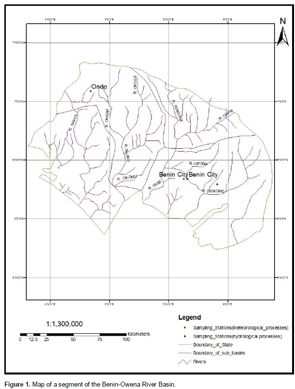
The study area has been detailed in the works of Ikhile (2007a,b). It lies between Latitudes 6o30’ to 7o35’N and Longitudes 4o50’ and 6o00’E (Figure 1). This includes parts of Edo and Ondo States of Nigeria. The climate is the tropical continental type with alternating wet and dry seasons of varying duration. The seasons correspond to the periods of dominance of the wet tropical continental air masses. The seasonal distribution of rainfall follows the direction of the Inter-Tropical Divergence (ITD) and varies almost proportionally with distance from the coast. The wet season occurs within seven months from April to October while the dry season lasts from November to March.
There is usually a break in rainfall in August. Specifically, the study area has annual mean rainfall ranging from 500 to 2,780 mm. About 90% of the rain falls in six to seven months of April to October. Mean annual temperature ranges between 24oC-33oC.
The mean number of hours of sunshine is 5-7 depending on the season. The rate of evaporation is high being the continental interior. The relative humidity is between 60-80% per annum depending on the season of the year (dry or rainy). The mean atmospheric pressure is about 1013 mb.
METHODS
The rainfall data used for this study were obtained from the Federal Ministry of Aviation, Meteorological Services (FMAMS) Oshodi, Lagos, and the Benin City Synoptic Station in Edo State. The rainfall data covered a period of forty years from 1961 to 2010. The rainfall was measured with a Stevenson’s automated rain gauge installed at the Lagos and Benin City Synoptic Stations. Rainfall for the period was recorded on monthly charts. Monthly, annual and decadal totals were used. The data were subjected to transformation using mean averages via regression analysis and GIS models. The results are presented in decadal and monthly means and displayed using charts, graphs and tables. Benin City was used to show the general variation in the climatic elements.
Statistical Analysis
The relationship among the different studied meteorological variables was assigned by computing the multiple regression coefficients (r). This model indicated the degree of relationships among rainfall, temperature and was used to predict the rate erosion in the river basin to climate change.
RESULTS AND DISCUSSION
Rainfall distribution for Benin City
Rainfall for the basin as a whole exhibited distinct patterns in the decades 1961–2000 as shown in Figure 2. The annual total for Benin during the decade 1961–1970 ranged from 1985 to 3049 mm for the years 1964 and 1965, respectively. The decadal total was 247,691mm (Table 1). January was particularly dry in 1964, 1967 and 1969, with zero values of mean monthly rainfall, while it was only 1970 that had no rainfall in the month of December (Figure 2). The decade 1971–1980 showed a different pattern. The total annual rainfall ranged from 1702 (1972) to 2585 mm (1980). In this decade, most January and December months were very dry (Figure 3) with zero rainfall values for up to five years (1973–1976, 1979). This decade was drier than the previous one. The decadal total was 20,050.51mm. The total annual rainfall for the third decade (1981–1990), ranged from 1227 to 2461 mm in 1986 and 1990, respectively. Between 1985 and 1989, Decembers were completely dry with zero rainfall values and January was also dry for many years. This decade was apparently the driest of the record. A similar observation was made by Olaniran and Sumner (1991). December 1990 recorded an unusually high mean monthly total of 168 mm, and this was the highest ever-recorded rainfall in December between 1961–2000. The decadal total was 235,493mm.
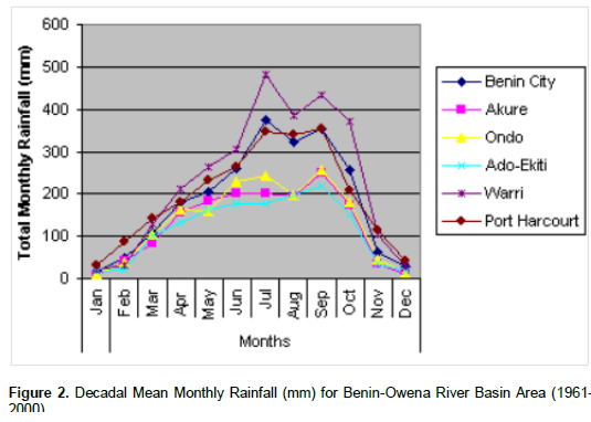
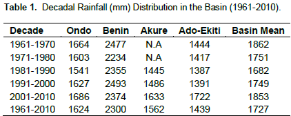
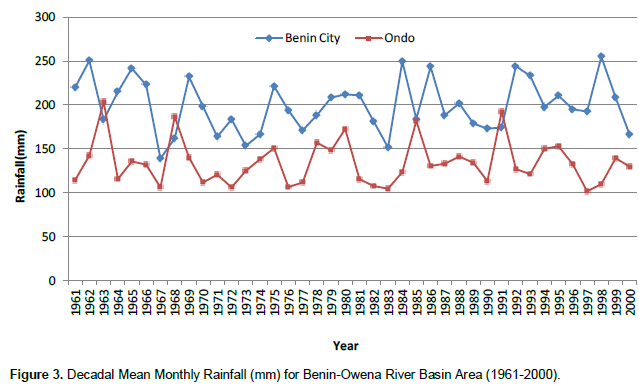
The total annual rainfall for 1991–2000 ranged from 1860 to 2776 mm in 1993 and 1992 respectively. December and January were not as dry as previously experienced (Ojo, 1987). The rains tended to fall in all months of the year, with the exception of 1992 and 1994 when the Decembers were dry. The decadal total was 24,932.23mm.
Generally, the first three decades showed double maxima of rainfall with an August break. In the fourth decade (1991–2000), the August break was absent with the August months recording generally higher rainfall values than all the other decades. This means that the normal pattern was reversed in this decade. Even the December months were very wet. January was generally the driest month with a total of 682 mm of rain from 1960–2000. July was the wettest month with a total of 14 975 mm of rainfall from 1961–2010.
Rainfall distribution in the drainage Basin
In Akure, the rainfall distribution in the decade 1981-1990 was fairly even (Table 1, Figures 2 and 3). The decade 1991-2000 recorded a higher decadal total rainfall and a more varied mean monthly rainfall distribution. The rainfall distribution of Ondo during the period of study (1961-2000) showed wide variability (Babatolu, 2002). The highest rainfall figure in the decade was recorded in 1963 (2,440.94mm) and the lowest was recorded in 1997 (1,217.10 mm). The rains decreased generally in the last decade (1991-2000).
The distribution of rainfall in Ado-Ekiti was rather erratic. The 1991-2000 decade seemed to have the highest wetness, and with more even distribution. All the months recorded rainfall with the exception of 1991-1993. The decadal rainfall totals however were lower compared with the other decades. The highest recorded annual total rainfall was in 1973 (2,734.4 mm) and the lowest was in 1964 (899.7mm). Annual rainfall totals tended to exhibit a reduced trend after every ten years (decade) in Ado-Ekiti (e.g. 1964-1974, 1983-1993).
Temperature distribution in Benin City
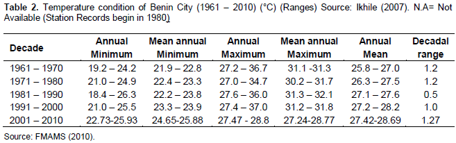
The temperature condition for Benin City is presented in Table 2. The annual mean temperatures increased steadily from 1961 to 2000. During the 1961–1970 decade, it was 25.8°C to 27.0°C (decadal range: 1.2°C). During the 1971–1980 decade, it was 26.3°C to 27.5°C (decadal range: 1°.2C). During the 1981–1990 decade, it was 27.1°C to 27.6°C (decadal range: 0.5°C).
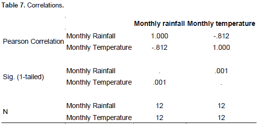
In this decade, the climate of Nigeria was described as playing a climatic drama (Ojo, 1987). The climate fluctuations were larger and the weather became more unpredictable. The last decade, 1991–2000, has been the warmest with annual mean temperature ranging from 27.2°C to 28.2°C (decadal range: 1.0°C). The air temperature appears to exhibit a persistent increasing tendency in Benin City coupled with decreasing rainfall. This may be an indication of global warming and climate change. There is a statistically significant relationship between mean annual rainfall and air temperatures in the study period at a 0.01 confidence level.
The temperature distribution for the period 1961–2000 showed a wide variation and a gradual warming of the environment. For the decade 1961–1970, the annual minimum ranged from 19°C to 24°C (January 1967 and February 1970) and the minima slightly increased over the following decades. The 1981–1990 decade showed the greatest extremes of temperature, recording the lowest and highest annual minimum temperatures for the whole period of study. The mean annual minimum followed a similar pattern. The annual maximum for 1961–1970 ranged from 27 to 36°C (July 1961 and March 1962) and remained approximately constant over the following decades. The year 1998 recorded the highest temperature of 37.0°C during the 40-year period. This is in line with Odjugo (2000). The annual mean maximum followed a similar trend
Temperature condition in the Drainage Basin
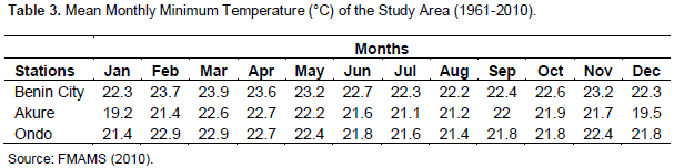
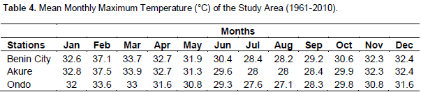
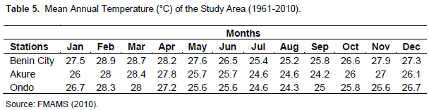
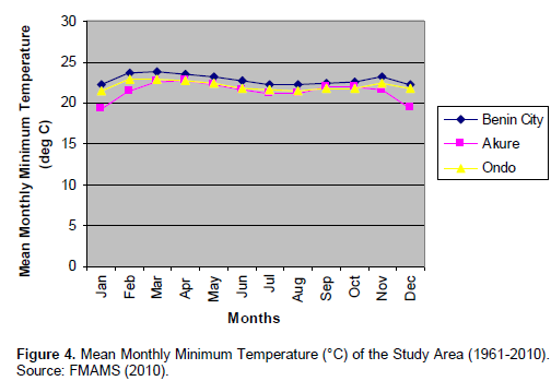
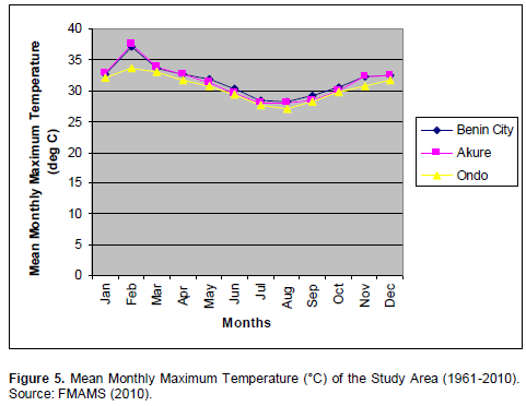
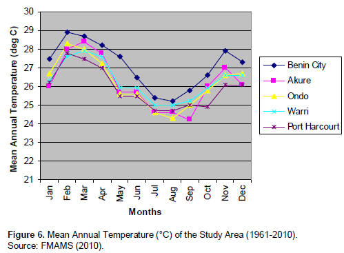
The mean annual temperature distribution of Ondo follows the same trend as for the maximum temperature distribution (Tables 3, 4 and 5, Figures 4, 5 and 6). The temperature has been on the increase rising steadily from 1961-2000. The distribution in the first decade was rather more uniform, though the decade ended with increasing temperatures. The second decade witnessed much extremes and variations, beginning and ending with lower temperatures. In the third decade, there was still more fluctuations and oscillations starting and ending with high temperatures. The fourth decade was most erratic and dramatic (Ojo, 1987).
The distribution of temperature in Akure for 1981-2000 was quite varied and a similar warming of the environ-ment was observed. All the measures of temperature ranging from minimum to mean annual showed increasing trend.
Soil erosion
Due to excessive rain in the past decade, most towns in the drainage basin have been seasonally afflicted with flooding and erosion (BORBDA, 2001). The effect of the menace has left some roads impassable and some buildings on the verge of collapse. In addition, many public utilities such as electric poles and water pipelines have been damaged due to the extensive soil erosion.
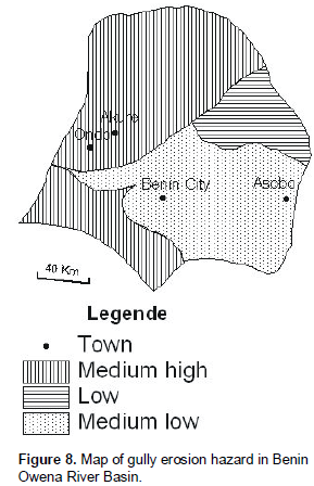
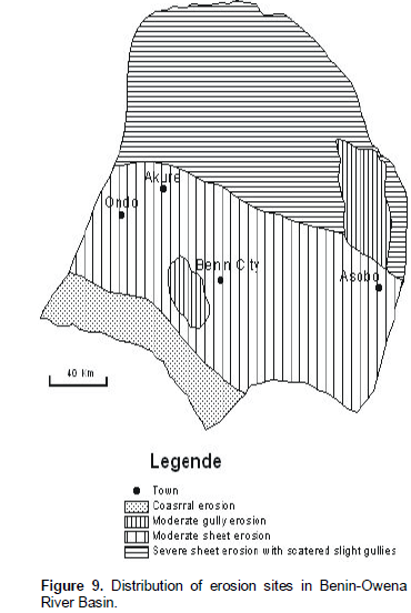
The most troublesome of all the erosion types is gully erosion (Figures 7, 8 and 9). This has necessitated the setting up of numerous soil erosion and flood control projects all over the drainage basin. The funds for the project run into millions of Naira and are usually released from the Nigerian Ecological Funds Office in the Presidency. The current projects include,
a) Ondo State
(i) Okitipupa (ii) Oke-Igbo (iii) Oka-Akoko
b) Ekiti State
(i) Ado-Ekiti (ii) Efon-Alaaye (iii) Orin (iv) Usi (v) Ilupeju
c) Edo State
(i) Auchi (ii) Uromi (iii) Ibore (iv) Queen Ede (iv) College Road, Benin City
d) Delta State
(i) Agbor (ii) Umutu (iii) Ubulu-Uku (iv) Issele-Uku
A few of these projects are discussed to illustrate the magnitude of the problem within the Benin-Owena River Basin.
Auchi Erosion Control Project
Auchi is a growing urban settlement in Etsako West LGA of Edo State. The town has been seasonally afflicted with flooding and erosion over the years and the environment left in pitiable condition. The degradation caused by the soil has undermined the foundation of many buildings and rendered many roads in the town impassable. This has resulted in abandonment and ultimate collapse of many buildings. In addition, many public utilities such as water pipelines and electric poles have been damaged as a result of this extensive soil erosion. BORBDA, in 1986 made an attempt at correcting this serious land degradation by commissioning a design firm to study and design erosion control works
The following streets/areas have been greatly devastated: (a) Magistrate Court, Igbe Road site. (b) Igbe Road, Jattu Road site (c) Warrake I site (d) Warrake II site (e) Polytechnic Gorge site (f) Iyekhei Gully site (g) Oshiobugie Gully site. The design in 1986 allowed for 77,000m3 of earthworks, 6,027km of drains to gulp about 4,836m3 of concrete. The project was executed at a cost of over sixty million Naira. This was funded by the Ecological Funds Office of the Presidency.
Benefits of the Erosion Control Project,
1. Construction of a ground total of 2.5km of concrete channel for the discharge of surface runoff, while gullies with a total volume of 150,000m3 have 30,000m2 of the reclaimed land surface grassed for slope protection.
2. Restoration of traffic flow after re-construction of the collapsed bridges, culverts and drainage channels.
3. Land enhancement resulting from river training and drainage channel works.
4. Improved aesthetics to the environment.
5. Improvement of health.
6. Substantial reduction to the state of anxiety of those living near the river, gullies or bottom of hills under whose building spring water used to ooze out.
7. Stopping for all times makeshift drainage channels constructed by individuals for diverting flood from their houses.
When these benefits were weighed against the cost, it was obvious that the project was economically feasible.
Uromi Erosion Control Project
Uromi is a growing urban settlement in the Esan South East Local Government Area of Edo State. The town has been seasonally afflicted with flooding and erosion over many years and the environment left in pitiable conditions. The degradation caused by soil erosion had rendered many roads in the town impassable. This had led to the abandonment and ultimate collapse of many of these buildings. The study carried out revealed that the following factors were responsible for the perennial flooding and erosion:
Rainfall: Uromi is in the forest zone. The rainfall here is moderately high, giving rise to high volume of runoff.
Vegetation Cover: The vegetation is sparsely distributed due to human activities to give way to physical development. The absence of thick vegetative cover gives room for scouring and denudation.
Inadequacy of existing drainage structures: The existing drainage structures were grossly inadequate for the type of rainfall intensity experienced in Uromi. Some streets had no defined drains to discharge the runoff. This led to the flooding of the streets and in the process getting eroded to the extent that they developed into gullies. By the time the study and design were completed, the following nine streets/areas were identified to have been devastated: 1. Oyomon Street, 2. Oyomon Lane, 3. Eguare Road, 4. Uje-Oro Road, 5. Eidonjie Street, 6. Awo-Uzia Road, 7. Ukoni/Uwalor Road, 8. Ojomon/Efadion Road, and 9. Mission Road.
To check the menace of flooding and erosion in these areas, the study and design proffered some preventive and remedial measures. The measures include the following: (i) Provision of adequately sized reinforced concrete drainage channel (ii) Backfilling of the area involved compacting the fill to a minimum of 100% B.S compaction (iv) Upgrading existing drains to adequately size, scouring-resistant reinforced concrete lined drains (v) Replacing all undersized drainage structures (such as culverts) with adequate sizes.
The project was estimated at a total cost of over fifty million Naira for its completion in the year 2000. The Ecological Funds Office of the Presidency equally funded it. The design in 1990 allowed for 16,000m3 of earthworks, 12.47km of drains that gulped about 4.471m3 of concrete. There is a total of 1.0km of concrete drain for the discharge of surface runoff. Gullies with a total volume of 10,038.6m3 have been filled with good quality laterite and compacted. Erosion continues to be dynamic in this area. Visits to these areas reveal degradation of the highest order, suffering, fear, anxiety and helplessness experienced by the people affected in all the communities in the Benin-Owena River Basin.
The project was estimated at a total cost of over fifty million Naira for its completion in the year 2000. The Ecological Funds Office of the Presidency equally funded it. The design in 1990 allowed for 16,000m3 of earthworks, 12.47km of drains that gulped about 4.471m3 of concrete. There is a total of 1.0km of concrete drain for the discharge of surface runoff. Gullies with a total volume of 10,038.6m3 have been filled with good quality laterite and compacted. Erosion continues to be dynamic in this area.
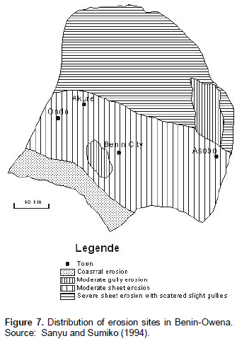
Visits to these areas reveal degradation of the highest order, suffering, fear, anxiety and helplessness experienced by the people affected in all the communities in the Benin-Owena River Basin. The degree of severity of gully erosion in the drainage basin is shown on Figures 6a, b and c.
Interpretation of statistical analysis
Regression
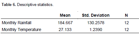
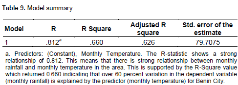
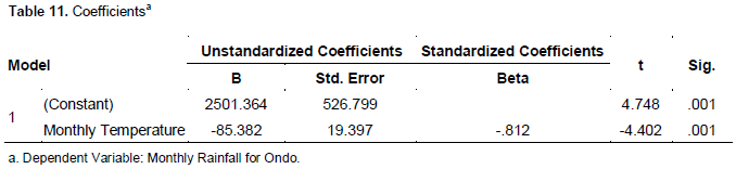
This is presented in Tables 6-11. The parameter estimate table shows that monthly temperature negatively and significantly predicts the changes in monthly rainfall. The Beta value depicted by “B” in the table for temperature is -85.382 which indicates that during temperature decrease, rainfall increases in Ondo.

CONCLUSION
Climate change has impacted on erosion activities in Benin-Owena River Basin of southwestern Nigeria. While the temperature is on the increase, rainfall remains sporadic and of high intensity. In Benin City, rainfall in the decade 1961-2000 exhibited distinct variations. Generally, the first decades showed double maxima of rainfall with an August break. In the fourth decade (1991–2000), the August break was absent with the August months recording generally higher rainfall values than all the other decades. This means that the normal trend was reversed in this decade. Even the December months were very wet. January was generally the driest month with a total of 682 mm of rain between 1960–2000. July was the wettest month with a total of 14 975 mm of rainfall between 1961–2000.
The annual mean temperature of Benin City increased steadily from 1961-2000. During the 1981-1990 decade, the climate of Nigeria was described as playing a climatic drama (Ojo, 1987). The climatic fluctuations were larger and the weather became more unpredictable. The last decade, 1991–2000, has been the warmest with annual mean temperature ranging from 27°C to 28°C (decadal range: 1.0°C). The air temperature appears to exhibit a persistent increasing tendency in Benin City coupled with fluctuating rainfall. This may be an indication of global warming and climate change. There is a statistically significant relationship between mean annual rainfall and air temperatures in the study period at a 0.01 confidence level. The temperature distribution for the period 1961–2000 showed a wide variation and a gradual warming of the environment.
RECOMMENDATION
The various organs of government must continue to take drastic steps to combat the menace of soil erosion resulting from continuous climate change impacts. This is because climate change is still very much with us today.
CONFLICT OF INTERESTS
The author has not declared any conflict of interests.
REFERENCES
| BORBDA (2001). Benin-Owena River Basin Development Authority – Briefs on Erosion and Irrigation Projects. | ||||
|
Brown TC, Froemke (2012). Nationwide assessment of nonpoint source threats water quality: Biosciences. 62(2): 136-146. Crossref |
||||
| Faniran AO, Ojo O (1980). Man's Physical Environment, London: Heinemann. | ||||
| Ikhile CI (2007a). Impacts of Climate Variability and change on the Hydrology and Water Resources of the Benin-Owena River Basin, Ph.D. Thesis, University of Benin, Benin City, Nigeria. | ||||
| Ikhile CI (2007b). Application of GIS in land-use studies in the Osse-Ossiomo River basin, Nigeria IAHS Publ, 316, pp 245-251, Oxfordshire, U.K. | ||||
| IPCC (2007). Climate Change : Impacts, Adaptation and Vulnerability Working Group II Contribution to the Intergovernmental Panel on Climate Change, Summary for Policy makers, IPCC Secretariat, Geneva, Switzerland. | ||||
| Nearing AM (2001). Potential Changes in Rainfall Erosivity in the U.S.with Climate Change during the 21st century. J. Soil Conserv. Water, 56(3): 229-232. | ||||
| Nearing MA, Pruski FF, O'Neal MR (2004). Expected Climate Change impacts on Soil Erosion rates: A Review. J. Soil Conserv. Water, 59: 1. | ||||
| Odemerho FO, Onokerhoraye AG (1994). Physical Geography, A Handbook for the Tropics, BJSSA, Benin City. | ||||
| Odjugo PAO (2000). The impacts of past and present trends in global warming on extreme weather conditions: global and local evidence. Asia Pacific J. Environ. Dev. 7: 53-69. | ||||
| Ojo O (1987).The Climate Drama, University of Lagos Press. Inaugural Lecture Series, pp 53. | ||||
| Olaniran OJ, Sumner GN (1991) Climate change in Nigeria: variation in rainfall receipt per rain day. Geo J. 22(1):242–249. | ||||
| Pender JS (2008). What is Climate Change? And how it will affect Bangladesh. Briefing Paper (Final Draft) Dhaka Bangladesh.Church of Bangladesh Social Programme. | ||||
|
Pruski FF, Nearing MA (2002a). Climate-indused Changes in Erosion during the 21st century for 8 U.S. locations, Water Resources Research: 38(12):1298. Crossref |
||||
|
Segura C, Sun G, McNulty S, Zhana Y (2014). Potential impacts of climate change on soil erosion vulnerability across the conterminous United States, J. Soil Water Conservation : 69(2):171-181. Crossref |
||||
| Sygna I (2005). Climate Variability in Cuba: The Social Networks. CICERO pp 2005 : 01. | ||||
Copyright © 2024 Author(s) retain the copyright of this article.
This article is published under the terms of the Creative Commons Attribution License 4.0


