Full Length Research Paper
ABSTRACT
This study investigated shallow groundwater quality and yield for irrigation along Hadejia River Basin of Jigawa State in both the dry and rainy seasons of one year. Sites in the floodplain with a history of irrigation where the use of tube wells is dominant were selected covering a transect of about 135 km. Six transects, oriented perpendicular to the river channel were established within 1 km2 in each site. Three tube wells were sampled and positioned along each transect at regular intervals, making a total of 18 wells in each site. To ensure quality control and quality assurance, the sampling standard methods prescribed by APHA (2005) were followed carefully for the collection of groundwater samples. Pumping test, which was repeated four times at 15 min interval in both morning and evening hours was used to measure groundwater yield. Multivariate statistical tools such as analysis of variance, Pearson product moment correlation, and cluster analysis were used respectively, to test the research hypothesis and to classify sampling points into similar groups based on groundwater quality. Results showed that the suitability of the water is lower in the dry season than in the rainy season. Average yield of wells for evening hours recorded a higher yield of 3.3 l/s (56%) than yield in the morning hours of 2.6 l/s (44%). Although groundwater average yield was found to be within the standard (2.5 l/s) for irrigation, it is realized that any extraction of the resource more than the prevailing rate can induce a decline in groundwater yield. A decision support system is recommended among the strategies to improve groundwater resources management in the area.
Key words: Shallow groundwater, condition, floodplain irrigation, River Basin.
INTRODUCTION
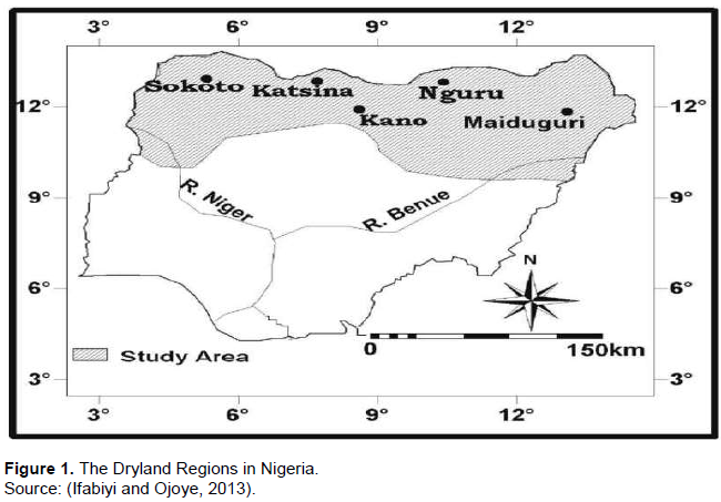
The importance of water to life on earth, particularly to human beings, becomes clearer when one considers its role or usefulness in various aspects of human endeavor (Olofin, 2011). As such, water is at the centre of Sustainable Development Goals (SDGs) numbers 1, 3, 6 and 16 (MDG Report, 2006). In many parts of the arid and semi-arid regions, reliance on groundwater has increased significantly mainly due to inadequate rainfall and the consequent surface water scarcity (Kumar et al., 2007). Many people in West African countries particularly in the dryland regions generally rely on groundwater sources for potable water (Nakoma et al., 2016). In many African countries such as Niger, Botswana, and Ghana, groundwater accounts respectively for 71.43, 50 and 47.56% of their total freshwater sources (Xu and Usher, 2006) and accounts for over 60.9% of the domestic supply in the Ejisu-Juaben municipality of the Ashanti Region of Ghana (Ghana Statistical Service, 2012). Similarly, groundwater is the main source of water to about 70% of the inhabitants of Meru City, Tanzania (Elisante and Muzuka, 2016). Although groundwater accounts for only 28.90% of the total freshwater in Nigeria (Xu and Usher, 2006), about 128 million people (85% of the total population) depended on this resource as at 2001 mainly due to the deterioration in the quality and quantity of surface water, insufficient water supply by water authorities, effect of climate change and above all rapid population growth (Akujieze, et al., 2003). In the drylands region of Nigeria (Figure 1), the interplay of climatic and geological characteristics makes surface water virtually inadequate, and as such groundwater appears to be the only reliable source of fresh water for domestic and agricultural use, principally in the Chad formation areas of these regions (Tukur et al., 2016).
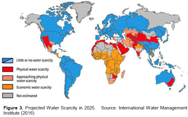
Globally, irrigation accounts for more than 70% of total water withdrawals and for more than 90% of total water consumption (Adhikary et al., 2015). As such, demand for freshwater, particularly for irrigation, has led to drastic depletion and deterioration of groundwater in several parts of dryland regions in recent decades such as Israel, Iran, Iraq (Sethy et al., 2016). Figure 3 shows projection of global water scarcity in 2025 classifying dryland under economic water scarcity. The development of irrigation has been identified as a key factor in the socio-economic growth of dryland zones of Nigeria, where agriculture is one of the major source of sustenance for a significant number of the population, principally the rural poor (Iliya et al., 2011). More than 90% of the rural populations in these zones have been predominantly engaged in rainfed agriculture (Ajon et al., 2014). However, due to climate change, rainfed agriculture is becoming unreliable as a result of erratic rainfall and variable surface water flow especially in the dryland regions of the country such as Jigawa (Tukur et al., 2017).
The fact that northern part of Kano Region lies in the semi-arid agro-ecological zone where rainfall is often erratic and inadequate in amount and distribution for production of some crops (Ajon et al., 2014), rainfed agriculture has been suffering from varying lengths and intensities of rainfall, thus necessitating irrigation in order to satisfy the moisture requirements of crops needed to meet the demands for food and fibre (Mays, 2009; UNESCO, 2004). For this reason, exploitation of shallow groundwater in the floodplain has increased greatly, because it is reliable and readily available at the point of need at relatively cheaper cost. Exploitation of groundwater therefore remains the only option to supplement the ever-increasing demand for irrigation water. However, risk of the degradation of floodplain aquifer may be developed as the competition for the utilization of its resources increases, particularly as researches have revealed that farming in the floodplain increased by 125% between 1976 and 1995 (Iliya et al., 2011).
Efforts towards groundwater protection for floodplain in Jigawa region are largely neglected, as a result of poorly effective groundwater management policy framework. Therefore, no groundwater protection regulation has yet been developed for the groundwater body in the floodplain and no comprehensive study supporting floodplain groundwater protection, principally the salinity, and infiltration hazards have yet been conducted in the region. To safeguard the long-term sustainability of the groundwater resources in the floodplain, and to overcome these limitations, both quality and yield of the resource need to be continuously monitored. Thus, regular monitoring of groundwater quality and yield with information about their temporal and spatial trends in the floodplain is imperative in order to detect any changes in quality and yield so that changes in management can be planned. Specifically, the paper aims at
i) Reviewing methodological approaches of groundwater studies for irrigation in the area.
ii) Determining groundwater yield and quality fluctuations for irrigation in the area, and iii) Recommending what should be the focus of groundwater management for sustainable irrigation in the area.
MATERIALS AND METHODS
Geographical background of irrigation river basins in the dryland of Northwestern Nigeria
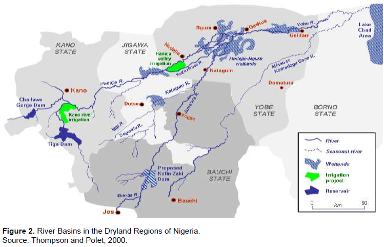
The characteristic of river basin of dryland regions in northwestern Nigeria is influenced by the climate, rock structure and human activities (Tukur et al., 2018). The climate of the area is characterized by rainfall variability of long-term annual total ranging from less than 600 mm in the northernmost parts with duration of 4 months for most of the years to other months being the dry season (Tukur et al., 2018). The basin of the area is dominated by the Hadejia River Basin which drains essentially northeastwards into the Lake Chad (Figure 2). Hadejia River is an example of a principal through-flow system in the Dryland regions of Nigeria. Like all stream flow regimes in the Dryland, the river basin of the area is characterized by large variations of flow between the wet and dry seasons, with the wet season having more flow of water than in the dry season.
The region has a long history of floodplain irrigation agriculture utilizing groundwater as the most reliable resources. The soil type of the area consists largely of unconsolidated porous sandy sediments in which aquifers exist in three layers, of which two top ones are accessible to borehole exploitations. Besides, there are alluvial deposits on river floodplain easily exploited for the groundwater through tube wells. Floodplain in the dryland regions of northern Nigeria is a low-lying floodplain land adjacent to seasonal river which retained moisture during the dry season. Groundwater in the floodplain serves as a risk mitigating mechanisms by complementing the seasonally limited and unreliable rainfall as well as years of poor rainfall (Dabi and Anderson, 1998).
With the inception of Hadejia Valley Project, more virgin lands were opened up to boost rice and wheat production. In order to ameliorate the deficiency in seasonally available rainfall for agricultural purposes, several approaches were developed to harness the abundantly available groundwater resources in the area. Prominent among such approaches are digging of water holes, sinking of wells, digging of wash bores and drilling of shallow tube wells. The drilling of shallow tube wells is the technique adopted by Kano Agricultural and River Development Authority (KNARDA) to assist small-scale floodplain cultivation in some identified and delineated areas where groundwater in shallow aquifers can be economically extracted for irrigation (KNARDA, 1989).
Procedure
A bibliographic survey based on Google Scholar Citation Index and the Science Citation Index Expanded (SCIE) database was conducted to evaluate groundwater-related research in the area covering different perspectives. Further, a survey of groundwater yield and quality in the floodplain along the basin was conducted covering a transect of about 135 km during two distinctive seasons of one year (dry and rainy) to investigate groundwater quality and yield condition in the region. Six transects were established within 1 km2 of each selected point along the basin and were oriented perpendicular to the river channel. Three tube wells were sampled and positioned along each transect at regular intervals making a total of 18 wells. A pumping test, which was repeated four times at 15 min interval in both morning and evening hours, was used to measure groundwater yield.
The sampling standard methods prescribed by American Public Health Association (APHA, 2005) were followed carefully for the groundwater samples collection to determine the concentration of water quality parameters. Four irrigation water quality indices including Electrical Conductivity (EC), Sodium Adsorption Ratio (SAR), Percent Sodium (%Na), and Permeability Index (PI) representing salinity and infiltration/permeability hazards, respectively were used to evaluate the quality condition of the groundwater for irrigation in the area. Three of the indices were computed using the following equations:
Pearson product moment correlation and 2-way analysis of variance were used, respectively to explore the relationship between groundwater yield and dynamic level on one hand and to determine the diurnal variation of groundwater yield at 5% level of significance.
RESULTS
Methodological approaches of groundwater studies for irrigation
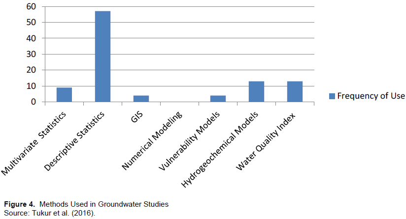
A bibliographic survey based on Google Scholar Citation Index and Science Citation Index Expanded (SCIE) was conducted to evaluate groundwater quality-related research from different perspectives covering a period of 14 years (2002-2016). This review revealed that, statistical approaches (66%), particularly the families of descriptive statistics (57%) are the dominant techniques used in all the studies. Hydrogeochemical methods (13%), Water Quality Index techniques (13%), Multivariate statistics (9%) and modeling techniques (4%) were found to be less admired and utilized (Figure 4). In all the studies, the use of Multivariate statistics, Geographical Information System (GIS), Artificial Neural Network (ANN), Structural Equation Modeling (SEM), Decision Tree Models (DTM), Index-based vulnerability models such as GOD, SINTAC, DRASTIC and numerical modeling such as MODFLOW were found to be lacking. The literature further revealed that, there is generally poor knowledge regarding the groundwater yield and quality condition from floodplain aquifers of the country since the commencement of shallow boreholes programme in 1986 (Tukur et al., 2017).
Groundwater yield and quality fluctuations
Annual variation of groundwater level and rainfall
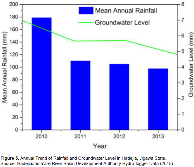
The findings of Tanko (2014), on groundwater availability in the floodplain of the region, revealed that the mean groundwater recharge contributed by river flow and rainfall accounted, respectively by 33 and 13%. The study further revealed, according to Tanko (2014), that groundwater beneath the floodplains dropped from 9,000 MCM in 1964 to 5,000MCM in 1987 (a drop of about one half of its initial value). In the same development, the finding of Umar (2016) on the variation of groundwater level revealed a positive relationship between rainfall and groundwater level variation. Thus, the study revealed a steady annual decrease of groundwater level from 2010 to 2013 in the area (Figure 5).
Diurnal variation of shallow groundwater yield
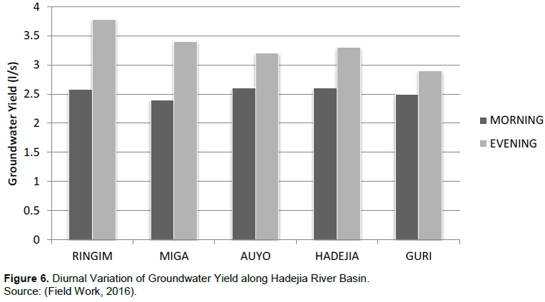
A survey of shallow groundwater yield along Hadejia River Basin revealed that, groundwater average yield in the flood plain along the basin was found to be within the standard (2.5 l/s) for irrigation. Although, yield in some locations, particularly, in Miga and Auyo have minimum average of 0.5 and 1.3 l/s, respectively, and are considered unsuitable for irrigation (Figure 6). Overexploitation of the aquifer due to intensive irrigation activities can be a reason for this lowest yield, as Auyo and Miga are among the leading floodplain irrigation towns, after Hadejia. Moreover, these locations coincided with the towns where tube wells were built by the Macdonald and Diyam Consulting Company in 1962 over three decades now. Average yield of wells for evening hours recorded higher yield (56%) than the yield in morning hours (44%), in the region with the result of 2-way ANOVA showing significant diurnal variation (p value 0.00<0.05) in the yield of wells. Furthermore, correlation test showed significant relationship between groundwater dynamic level and yield among the study locations (p value, 0.045<0.05).
Seasonal variation of groundwater quality indices
Understanding the quality of groundwater with its seasonal and spatial variation is important because it is the factor that determines the suitability for different purposes. Areas with shallow water table (< 10 m) like floodplain are the most widely known hydrogeological settings with a high tendency to have natural seasonal variation in groundwater quality. Therefore, this study covers both dry and rainy season to see if there is any significant changes in the suitability of water for irrigation.
Sodium adsorption ratio: Richard (1954) suggested a classification of groundwater suitability for irrigation based on SAR. The relative concentration of sodium, magnesium, and calcium in water, known as the Sodium adsorption ratio (SAR), is used to measure the sodium hazard in irrigation water. Excessive sodium content reduces the soil permeability and thus, inhibits the supply of water needed for the crops. The mean value of SAR varied from 6.05 to 6.96 meq/l in the rainy season and 5.12 to 5.67 meq/l in the dry season in all the study locations. In view of the SAR classification, 100% of Ringim, Miga, Auyo and Guri groundwater samples in both seasons fall in the excellent category which can be used for irrigation on almost all soils, while in Hadejia, only one tube well (6%) shows SAR value under good for irrigation in the dry season. Therefore none of the samples are of unsuitable category for irrigation in either of the seasons.
A more specific test for the suitability of water for irrigation was made by plotting the data on the United State Salinity Laboratory diagram (USSL, 1954) in which EC is taken as salinity hazard and SAR as permeability hazard (Richard, 1954). The analytical data plotted on USSL diagram (Figure 7) illustrates that almost all the groundwater samples in all the season belonged to C3-S1, suggesting a high salinity and low sodium hazard for the groundwater, a category that could be used with high amount of leaching occurrence and with moderate danger for the development of harmful levels of exchangeable sodium.
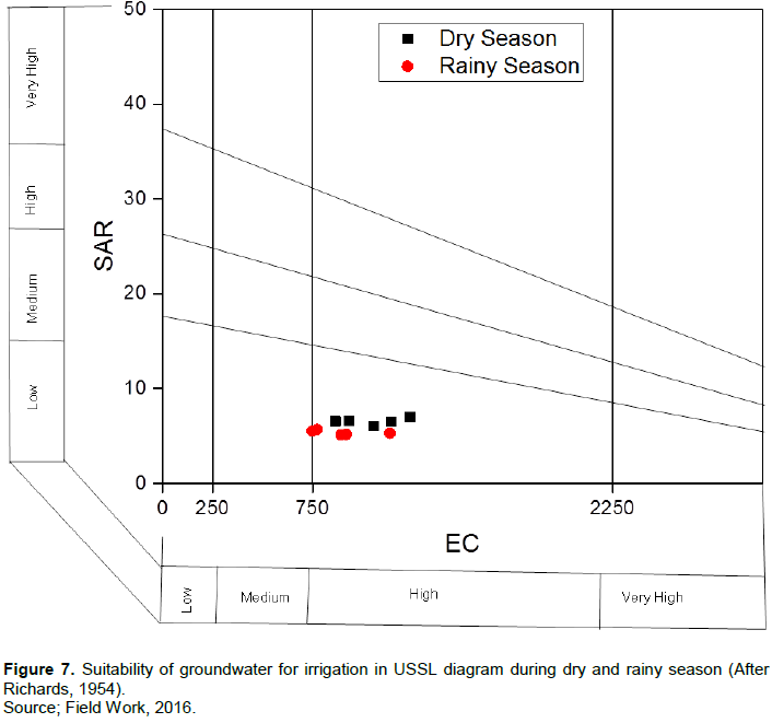
Plants with high and moderate salt tolerance such as cotton and wheat could be grown in C3-S1 irrigation water. Although irrigation with this class of water has little danger for the development of harmful levels of exchangeable sodium, it cannot be used on soils with restricted drainage. Even with adequate drainage, special management for salinity control may be needed, but plants with good salt tolerance such as cotton and date palm should be selected for C3-S1. However, cotton and date palm are not cultivated in the floodplain of Ringim based on the report of interview conducted with the farmers.
Sodium percent: Concentration of sodium in irrigation water is also known as the sodium percent or soluble sodium percent (%Na). Sodium concentration is important in classifying irrigation water because sodium reacts with soil to reduce its permeability (Wilcox, 1955). Figure 8 presents the result of %Na in the groundwater samples of study area. From the figure, almost 100% in dry season and rainy season of the groundwater samples fall within good to permissible class for irrigation. None of the sample falls within either excellent to good, doubtful to unsuitable or unsuitable class. Therefore, groundwater samples in the area cannot cause soil aggregates to disperse; hence, they are suitable for irrigation.

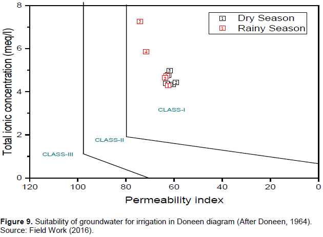
Permeability index: Another significant water quality factor that influences soil permeability is the permeability index (PI) developed by Doneen in 1964. This is because the soil permeability is affected by the long-term use of irrigated water rich in sodium, calcium, magnesium and bicarbonate. For that, Doneem (1964) classified irrigation water in three PI classes. Class-I and Class-II water types are suitable for irrigation with 75% or more of maximum permeability, while class-III types of water with 25% of maximum permeability are unsuitable for irrigation. Based on the Doneen’s classification presented in Figure 9, over 90% of the groundwater samples from all the study locations fall in Class-I and II, implying that the majority of the groundwater samples is suitable for irrigation.
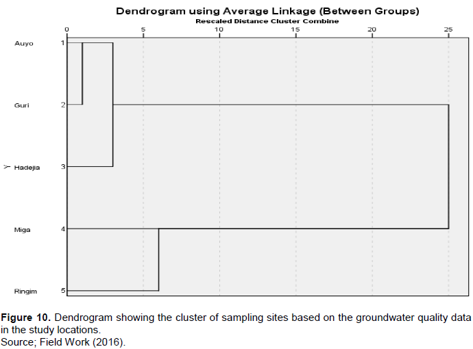
Spatial similarities of groundwater quality
Cluster analysis was applied to detect spatial similarities in the concentration of physicochemical parameters of Fadama groundwater among the five sampling locations. To achieve this, all the physicochemical parameters were used as variables and treated. The result is the dendrogram in Figure 10 which groups the five sampling sites along the basin into three statistically significant clusters in terms of groundwater quality concentration as follows: Cluster 1 (Ringim), Cluster 2 (Miga) and Cluster 3 (Hadejia, Guri and Auyo). Clusters 1 and 2 respectively, comprising of Ringim and Miga suggested dissimilarities in their groundwater quality. The last cluster comprising of Hadejia, Guri and Auyo suggested similarities in their groundwater quality. The implication of the findings is that, groundwater quality declines towards northeast along the basin. The advantage of using this technique is that, it offers a reliable classification of groundwater quality in the whole basin. Thus, instead of monitoring groundwater quality from five sites in future studies, three sites could be selected for sampling without affecting the overall result. The reduction in sampling sites along the basin would be more economical and without any loss in the outcome.
DISCUSSION
A two-way ANOVA between subject effects factor design was performed on the data set to explore the statistically significance of the groundwater variations and the mean differences spatially and temporally in the five study locations cited earlier. The temporal variations considered were the seasons (dry and wet). The seasonal variations of all the 14 physicochemical parameters showed that only CO32 has no significant seasonal variations (p value, 0.212>0.005) in the 5 study locations. Thus all the remaining parameters investigated (Temperature, pH, EC, TDS, K, Na, Ca2+, Mg2+, HCO3- Cl-, NO3-, SO42- and B) have significant seasonal variation (p<0.05). The variation of each of these parameters in the 5 study locations was further explained using the post hoc (LSD) test. LSD test revealed that the concentration of these parameters varied between Hadejia and all other four study locations. This result supported the laboratory result which showed higher concentration of physicochemical parameters in the dry season of the study period. For spatial variation, Ca2+ and Mg2+ in addition to CO32 have no significant spatial variation in the study locations, respectively with a p-value 1.76, 1.53 and 0.23 all above the confidence value (p>0.05).
However, Ca2+ and Mg2+ showed significant seasonal variation (p<0.05). In other words, CO32 is the only parameter that did not show significant spatial and seasonal variation in the study locations. Spatially, results from laboratory analysis showed that groundwater samples from Fadama land in Hadejia have higher concentrations of these parameters than in the other four locations, thereby supporting the outcome of Post hoc test. The findings further revealed that groundwater yield and quality varied between dry and wet season, with the dry season having more quality and yield decline than in the rainy season. A steady annual decrease of groundwater level was observed from 2010 to 2013 in the area. Cluster analysis grouped all the 5 sampling points into three statistically significant cluster based on the groundwater quality. Permeability hazard has no problem as majority of the indices (SAR and PI) show excellent to good water for irrigation. Only %Na show good to moderate water for irrigation. This is in line with the findings of Ajon et al. (2014) in the floodplain along River Katsina-Ala Catchment Area, Northern Nigeria.
CONCLUSION
An evaluation of groundwater yield and quality for flood-plain irrigation along Hadejia River Basin of Jigawa State, northwestern Nigeria was undertaken. Combinations of multivariate statistics, and graphical models were used to provide a comprehensive understanding of the condition of shallow groundwater in the floodplain for irrigation. The following conclusions were reached.
i) Both groundwater yield and quality were found to be under the permissible limit set by irrigation standard of FAO (1998). Thus, groundwater in the area is fit for irrigation. Groundwater yield did not vary across the 5 sampling sites along the basin. This was supported by the result of 2-way ANOVA (p value, 0.286>0.05). However, average yield of wells for evening hours recorded higher yield (56%) than the yield in morning hours (44%), in all the study locations with the result of 2-way ANOVA showing significant diurnal variation (p value 0.00<0.05) in the yield of wells. Furthermore, correlation test showed significant relationship between groundwater dynamic level and yield among the study locations (p value, 0.045<0.05).
ii) Seasonally, all the physicochemical parameters of groundwater showed significant seasonal variation except CO32. Dry season was found to have more concentration of these parameters than in the rainy season, suggesting the impact of evaporation which causes these parameters to precipitate in the groundwater. With the exception of Ca2+ and Mg2+ and CO32, all other physicochemical parameters showed significant spatial variation among the 5 sampling sites, with groundwater from Hadejia sampling sites recording higher concentrations.
iii) In term of methodological approaches, the study revealed that the use of Artificial Neural Network, Structural Equation Modeling, Decision Tree Models and numerical modeling such as MUDFLOW were found to be lacking especially for irrigation water quality studies in the Dryland of Nigeria.
iv) Monitoring of groundwater dynamic levels, yield and quality is very important to sustainable Fadama land irrigation. Also, instead of gathering data for the exercise from many individual sites, the sites can be grouped into clusters of similar characteristics and a single sample from an appropriate site in a cluster will appropriately represent all the Fadama land sites in the cluster.
CONFLICT OF INTERESTS
The author has not declared any conflict of interests.
REFERENCES
|
Adhikary PP, Chandrasekharan H, Trivedi SM, Dash CJ (2015). GIS applicability to assess spatio-temporal variation of groundwater quality and sustainable use for irrigation. Arabian Journal of Geoscience 8(5):2699-2711. |
|
|
Ajon AT, Utsev JT, NNai CC (2014). Physicochemical quality of irrigation water in river Katsina-Ala catchment areas of northern Nigeria. Current World Environment 9(2):301-311. |
|
|
Akujieze CN, Coker SJL, Oteze GE (2003). Groundwater in Nigeria – a millennium experience – distribution, practice, problems and solutions. Hydrogeology Journal 11:259-274. |
|
|
Baba J, Swindell K, Mortimore M (1989). Inequality and development: case study from the third world. (eds), Macmillan. |
|
|
Dabi DD, Anderson WP (1998). Water scarcity and sustainable agricultural development in drought-prone semi-arid zone of west Africa. In: Demaree G, Alexandre J, De Dapper, M (Eds.) Proceedings of the international conference on Tropical climatology, meteorology and hydrology, held in Brussels, Belgium pp. 693-709. |
|
|
Elisante E, Muzuka ANN (2016). Assessment of sources and transformation of nitrate in groundwater on the slopes of Mount Meru, Tanzania. Environmental Earth Science 75:277. |
|
|
Ghana Statistical Service (2012). Housing and population census report. Ghana statistical service, Accra. |
|
|
Hadejia river basin development authority hydro logger data (2015). |
|
|
Ifabiyi IP, Ojoye S (2013). Rainfall trends in the sudano-sahelian ecological zone of Nigeria. Earth Science Research 2(2):194. |
|
|
Iliya MA, Muhammad-Baba TM, Oppon-Kumi A (2011). Climate change, land degradation, forced migration and farmers-pastoralists conflicts in the Sokoto-Rima basin in northwestern Nigeria: observation and extrapolations. Paper presented at the first national conference on climate change, 24th May, 2011, Bayero University Kano, Nigeria. |
|
|
International Water Management Institute (2016). Projected water scarcity in 2025. |
|
|
KNARDA (1989). Work programme proposals prepared by the monitoring and evaluation unit, Kano Agricultural and River Development Authority- KNARDA |
|
|
Kumar M, Kumari K, Ramanathan AL, Saxena R (2007). A comparative evaluation of groundwater suitability for irrigation and drinking purposes in two intensively cultivated districts of Punjab, India. Environmental Geology 53:553-574. |
|
|
Mays LW (2009). Integrated urban water management: arid and semi-arid regions, UNESCO, France. pp. 1-73. |
|
|
MDG (2006). The millennium development goals report. United Nations Newyork. |
|
|
Nakoma O, Chidya RCG, Matamula S, Chawinga CBJ (2016). Evaluation of borehole water quality in rural-areas of Northern Malawi: case of Zombwe in Mzimb. Physics and Chemistry of the Earth |
|
|
Olofin EA (2011). MLR 8222, Project design and appraisal, M.Sc lecture note, department of geography, Bayero University Kano, Nigeria. |
|
|
Richards LA (1954). Diagnosis and improving of saline and alkali soils, united state department of agriculture, Washington, USA. |
|
|
Sangari DU (2006). An evaluation of water and land uses in the Kano river irrigation project, Phase I, Kano State. Department of Geography, Nassarawa State University, Keffi, Nigeria. |
|
|
Sethy SN, Syed TH, Kumar A, Sinha D (2016). Hyrogeochemical characterization and quality assessment of groundwater in parts of southern gangetic plain. Environment Earth Science 75:232. |
|
|
Tanko AI (2014). Water resource development and management. In: (ed) Tanko and Momale, Kano: environment, society and development, Adonis and Abbey, London and Abuja P 228. |
|
|
Thompson JR, Polet G (2000). Hydrology and land use in a sahelian floodplain wetland. The Society of wetland Scientists 20(4):639-659. |
|
|
Tukur AI, Garba I, Mustapha A, Umar DA, Sulaiman WNA (2016). An overview of groundwater quality studies in developing countries, paper presented at the 52nd Annual international conference and exbihition of the Nigerian Mining and Geosciences Society (NMGS), Banuet Hall, Opposite Government House, Ilorin, Kwara State, Nigeria, 13th to 18th March, 2016. |
|
|
Tukur AI, Yusuf MA, Tanko AI, Garba I, Sulaiman, WNA (2017). An overview of methodological approaches to groundwater quality studies in Nigeria, paper presented at the 58th conference and annual general meeting of the Association of Nigerian Geographers, Department of Geography, Nasarawa State University, Keffi. 12th to 17th March, 2017. |
|
|
Tukur AI, Nabegu AB, Umar DA, Olofin EA, Sulaiman WAS (2018) Groundwater condition and management in Kano region, northwester Nigeria. February, 2018, 5(1):16, |
|
|
Umar MH (2016). Analysis of groundwater fluctuation in Hadejia, Unpublished B.Sc thesis, Department of Geography, Kano University of Science and Technology, Wudil. |
|
|
UNESCO-WWAP (2004). Water for people – water for life. The United Nations, world water development report. UNESCO Publishing, Paris, France. |
|
|
Xu Y, Usher B (2006).Groundwater pollution in Africa. Taylor and Fransis Group P 23. |
|
Copyright © 2024 Author(s) retain the copyright of this article.
This article is published under the terms of the Creative Commons Attribution License 4.0


