The ever increasing demand of farmland, fuel wood and charcoal production coupled with population growth has accelerated the rate of forest reduction in Ethiopia. This has resulted in soil erosion and land degradation. This study was conducted at Arba Minch Zuria Woreda Gamo Gofa Zone, Southern Nations and Nationalities Peoples’ Region (SNNPR), with the aim of assessing impacts of deforestation on the livelihood of small holder farmers. Both qualitative and quantitative data were collected from primary and secondary data sources. Data on the socio-demographic variables as well as farmers’ perception towards impacts of deforestation, were collected using structured questionnaire from 180 randomly selected households from each study sites. The overall average age of respondents was 46.29, where the highest age was recorded in Mille site as compared to other sites (P<0.001). The average household (HH) size of each site was 6.62, 5.52 and 4.82, respectively (P<0.001). About 89.4% of the respondents from all study sites indicated the existence of unwise utilization of forest resources which led to environmental degradation of the area. The result indicated that 27.2% of the forest resources are common woodland, while 72.8% was open access. All the respondents (100%, N= 180) across the study sites reported that the increased trends of degradation of forest resources. Generally, the results of the study indicated that the effects of deforestation on land productivity; agriculture and livestock production had a negative effect on livelihoods of the community. Based on the present study, it is appropriate to undertake the large-scale natural resource management by incorporating community-based watershed management, thereby reducing the adverse impact of deforestation.
Forests play an important role in the environment like providing the basic necessities, providing habitat for the variety of wildlife species, contribute to the control and moderate climate, prevent soil erosion and flooding; despite the benefits obtained from forest ecosystem goods and services, the clearing of forest and deforestation have contributed to the continued decline of forest resources in Ethiopia.
According to FAO (2000), tropical forest covers 814 million ha, of which 110 million ha is located in Africa, 168 million ha in Asia and the Pacific, and 536 million ha in Latin America. However, only 25 million ha are exploited in a sustainable way and 11 million ha of tropical forests are conserved with an effective political protection. All the tropical humid forests in Africa suffer from a massive deforestation (Soury, 2007). Loss of biodiversity of tropical forests is mainly due to degradation and destruction of habitat by anthropogenic activities. Currently, it is a global problem (Sukumaran and Jeeva, 2008) because the annual rate of global deforestation is about 13 million hectares, most of which occurs in the developing world. Forest loss in Africa is particularly troubling, however, two-thirds of the continent’s population depends on forest resources for income and food and 90% of Africans use fuel wood and charcoal as sources of energy. Despite, or perhaps because of this dependence on forest resources and non-timber forest products, deforestation in Africa is estimated at about 3.4 million hectares/year (CIFOR, 2005; FAO, 2010). However, most of these species have been vulnerable to different factors that led to the devastation of natural forest resources and diminishing of the forest cover. In relation to the causes of deforestation in Ethiopia, several factors have been mentioned. According to Tadesse and Demel (2001), deforestation usually followed human resettlement patterns.
In sub-Sahara Africa, majority of the population derives its livelihood from agriculture. Smallholder agriculture accounts for 75% of agricultural production of which the majority constitutes of rain fed farming. Drought is Africa’s principal form of natural disaster which often affects rain fed agriculture dramatically. The impact of population growth in rural areas is pushing communities into unsustainable farming practices such as burning and razing of tropical forests in order to plant crops, planting in steep slopes, moving into fragile marginal eco-system, over cropping and over grazing and subsequent depletion of fragile arable land and over-utilization of ground water resources. It has been estimated that a sixth of the world’s land area, nearly 2 billion hectares, is now degraded as a result of overgrazing and poor farming practices. Water resources for agricultural purposes are getting scarce, and there are hardly any land reserves to be brought into production to widen the agricultural base. By 2025, close to three billion people in 48 countries will be affected by critical water shortage for all or part of the year. Gebremarkos and Deribe (2005) pointed out that, lack of proper forest management and utilization, land tenure policy, lack of compatible forest proclamation and other legislations, and extensions of cultivation to marginal lands were indicated as major causes of deforestation. According to Demel et al. (2003), the underlying causes of deforestation are, closely linked with the vicious cycle of mutually reinforcing factors that means poverty, population growth, poor economic growth and the state of the environment. With regard to the effects of deforestation, Legesse (2003) argued that the decimation of natural forests results in the loss of a large number of forest products, drought, flooding, interrupts water flow, declines in land productivity and exacerbates misery and poverty of the rural people. Moreover, as illustrated in Ermias (2003), in Amhara regions alone, about 2 to 3.5 billion tons of fertile top soil is washed away per annum and deposited into rivers. Demel et al. (2003) argued that the reduction of vegetation cover and the associated negative impact on land, threaten ecosystems, flora and fauna by depleting genetic resources as well as loss in biodiversity. Considering the longitudinal profile of deforestation in Ethiopia, it should be clear at the outset that there have been no reliable records on the extents of the country’s forest prior to recent times (Yigremew, 2001). Mooney, the modern forestry expert, as noted by Pankhurst (1992), has argued that Ethiopia was densely wooded in ancient and not so remote times. But, it appears that there is no way of establishing how much of the country was actually forested, or at precisely what period and at what rate deforestation was occurred (Pankhurst, 1992). However many authors, based on existing indigenous remnant forests available in portions of the country and ecological settings, have tried to reconstruct the forest cover in remote and recent pasts. The various estimate made by different authors show that once in the remote past, about 30-48% of the country and as much as 87% of the highlands, were covered by forests vegetation (Yigremew, 2001). According to Tewolde (1996), most of the high lands had been deforested at least by the 16th century, and probably as early as the 16th century. Towards the beginning of the 1900s, however, the forest cover of the country was estimated at 40% of the area of Ethiopia. Depletion of forests had been 6-20% in 1950-1960, and had accelerated since the late 1960 and early 1970, the rate in this period, was estimated in the range of 2-6%. The acceleration of forest degradation in this particular period, according to Edessa (1993), was due to changes in climate of the country. On the other hand, Dessalegn (1996) largely attributes it to change in government and land use policy.
In the previous years, the Gamo-Gofa people used to protect remnant forests for varieties uses such as: traditional assembly places, production of household equipment’s, energy sources and others. The Gamo people are bound intimately with the land and land resources, which frequently contributes to environmental disruption and thereby maintaining an overall ecological equilibrium. In the highlands, the Gamo have protected sacred forests along waterways and on the tops of hills, these being the remnant forests of formerly vast Afromontane woodlands (Desalegn, 1996). Within the groves, the people keep their ritual relics and perform sacrifices, healings, harvest rituals and fire ceremonies that symbolize the connection between the past and the future. All of which recognize the peoples’ dependence on the earth and its resources to sustain their livelihoods.
The distribution of the land use in Arba Minch Zuria Woreda has been changing greatly over time because of subsequent cultivation after deforestation due to high population and economic pressures, and infrastructure and irrigation development (Tuma, 2007). Currently, a small part of the border area near Lake Abaya is covered with forest, whereas the highland that was once covered by forest is now deforested. In the escarpment between lowland catchments and highland areas, the scattered trees were also disappearing from those places. However, nowadays these important traditions which are tourist attraction sites and sources of country economy have been changed in other land use system Thus, this study attempts to assess the perception of local community to the impact of deforestation. The current research was to explore local community perception towards deforestation and decreased income, thereby livelihood. Specifically, it attempted to determine the impacts of deforestation on the livelihood of the community. The identification of the perception of local community towards deforestation and the local knowledge and their roles in forest management activities were also key specific objectives of the study.
Description of the study area
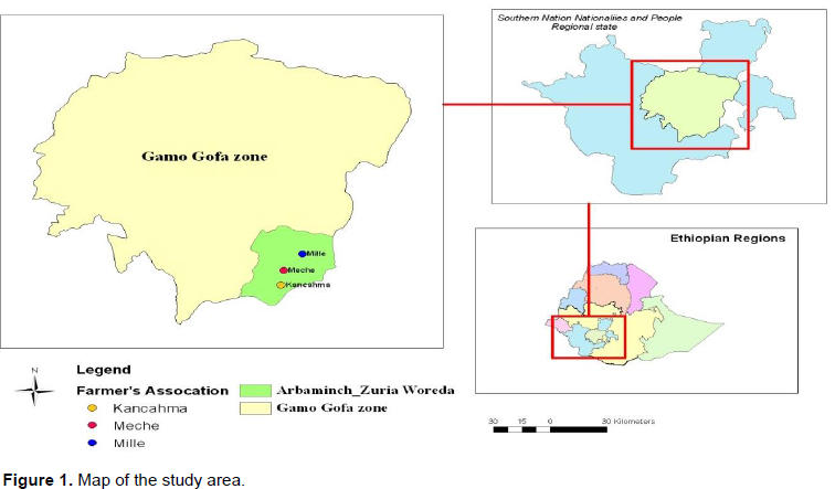
Arba Minch Zuria woreda is in the Southern Nations, Nationalities and Peoples' Region is located between 6°05´N to 6° 12´N and 37°33´E to 37°39´E, it is a part of Gamo Gofa zone 400 km south of Addis Ababa (Figure 1). It is bordered on the south by the Dirashe woreda, on the west by Bonke, on the north by Dita and Chencha, on the northeast by Mirab Abaya, on the east by the Oromia National Regional State, and on the southeast by the Amaro special woreda (Defaru, 2006).

The total population of the study area is 164,529. Out of the total population, 82,199 are men and the rest 82,330 are women (CSA, 2007). The family size of each house hold is an important factor to determine the nature of supply and consumption of forest product by respective house hold. Thus, family size of each house hold was considered. Family size is another demographic aspect which shows the status of family. The average family size of the area is 6 which are more than district’s family size. Therefore, the density of population in the area is 9-10 persons per ha (Defaru, 2006).
Topographically, the study area is characterized by escarpment and narrow valleys. The slope ranges between 20 to70% which resulted in massive soil erosion and altitude lies between 1190-3200 masl. The drainage patterns follow the general topographic orientation so that small rivers rising from Gamo highlands drain to Lake Abaya and Chamo. Among these, Hare and Baso drain to Lake Abaya whereas Kulfo, Sile and Sego rivers drain to Lake Chamo (Arba Minch Zuria Woreda Rural Development Office, 2008/09). The geology of the lower part of the study area is of recent or quaternary volcano which serves as a substrate for the dry Afromontane vegetation (Friis and Mesfin, 1992).
Accordingly, it is mainly quaternary volcanic alluvial deposits and lacustrine clay, Mateos (2003) stated that the soils under the forest and the state farm are composed of three main types: Fluvisols, Gleysols and Vertisols. Fluvisols consist of soil materials developed in alluvial deposits and flood plains.
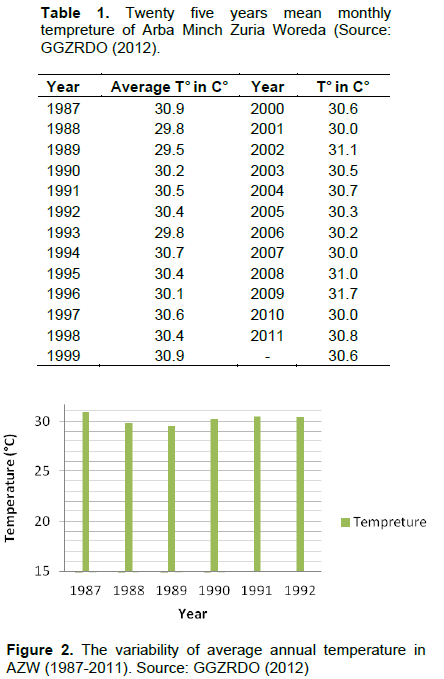
The mean monthly temperature is 23.9°C varying between 22.7 (July) to 25.7°C (March). Rainfall distribution in the study area is bimodal with a long rainy season from the beginning of March to the end of May with maximum rainfall around the month of April (228 mm), and a short rainy season from mid-August to mid-October. The minimum rainfall is recorded in January (18 mm) (FAO, 2010). The 25 years maximum average temperature trends of the study area were displayed (1987-1999 and 2000-2011), average maximum temperature difference in the years were 30.3 and 30.6°C, respectively (Table 1 and Figure 2). The minimum temperature trends showed variation before and after 1996.

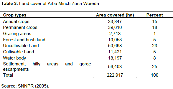
The land use land cover is combined with open space and readily available pasture, means that high agricultural yields and livestock production are possible. Most of the people in the area use traditional system of crop production. This includes, ploughing with oxen and with traditional hand tools in areas of steep slopes like Meche kebele. This was also one factor for the rapid destruction of forest resources which was followed by population growth of the area (Defaru, 2006). Varieties of food crops and fruits are grown: Maize is the primary food crop followed by sorghum, teff and barely, respectively. Irrigated banana, mango and cotton are primary cash crops, Livestock production, including the fattening of oxen, is another important income source. Much of the Woreda land was under settlement, hilly areas and gorge escarpments (Table 3).
Land holding size
According to the farmers associations administration, the range of land holding for the sampled households head in Mille 0.25-0.5 ha, in Meche 1.0-1.5 ha and in Kanchama 0.5- 2.0 ha was recorded. Majority of the people depend on rain-fed agriculture and cultivate maize and sorghum as their main crops. During the early and late dry period of the year, the people burn vegetation to clear bushes for agricultural purposes.
Methods
Research design
Survey was carried out to collect primary data to generate reliable information on the intended topic. Three representative kebeles namely, Mille, Meche and Kanchama which are among the major areas where selected for their forest area coverage. The fieldwork for this study was carried out from mid-November to January 2014. Face to face interview using questionnaires was adopted to gather information based on the prepared questionnaires. The questionnaire was developed with the objective of obtaining meaningful information and views from the household members living within the study area and from the key informants. The key Informants including community representatives and elders, experts at district office of Agriculture and development agents who are assigned at community level were considered in the survey. Data was collected by well-trained personals who are well acquainted with each kebeles and trained before the start of the data collection. The first two days of the survey period was devoted to training the data collectors by which they were tolerant to how to handle the respondents and fill the questionnaires.
Sampling techniques
A simple random sampling method was used to select sample households for the household survey; three Farmers Associations (Mille, Meche and Kanchama) were selected purposively. At this stage, the researcher took great care to ensure that the selected kebeles sufficiently represented the district in terms of socio-economic and physical characteristics. Secondly, the sample household heads were selected from each kebeles using simple random sampling method. This was carried out based on the list of households registered in the respective farmer’s associations obtained from Keble Experts and administration. These were 1034, 460 and 1195 registered households identified from Mille, Meche and Kanchama kebeles, respectively. At this stage, the development agents (DAs) and kebeles officials were consulted to identify the location of each household's residence within kebeles. The sample respondents were then taken. Respondents were selected at uniform intervals from the prepared alphabetical list of the whole household heads living in each Keble near the forest patches. To determine the sample size of households to participate in the study, large sample approach was selected following Wooldridge (2000).
According to data obtained from Kebeles Administrative and Development Agents (2006), there are about 1034, 460 and 1195 household units in Mille, Meche and Kanchama kebeles, respectively. And a total of 2689 household heads live in the Kebeles. From this, 250 households (P) are town inhabitants and out of the total households, 180 where selected for interviews. Therefore, 60 is the minimum sample size of housing units for reliable result. However, to be safe in the cases of some absences of household and unexpected problems during data collection and other cases, the sample size was increased to 180 randomly selected households. The sample size taken from each study sites near the forest patches (Kebeles) was sixty (60). Focus group discussions and field observations were also made to validate the data obtained by interviews and questionnaires. Discussions were made within three groups of different individuals in the community. Field observations were made and tried to grasp knowledge on some of the environmental and socio-economic conditions of the kebeles. Literature review, covering past research studies and relevant documents was carried out to gather secondary data. This include, journal articles, performance reports and research papers prepared and presented for policy discussions and conferences, and other relevant documents from the concerned administrative offices. The primary data were collected from selected households using structured questionnaires, interviewing guides and key informants and FGD. The questionnaires were filled by sample household heads living in three Farmers Associations and the interview was held with many individuals ranging from the elder group of community to the officials and experts in the field. Some of the interviewees were elderly persons, kebeles officials, youngsters, women, development agents (DAs) and experts at the districts office of agriculture and rural development. Focus Group Discussion (FGD) was also conducted to gather information related to historical records of forest resources utilization and management.
Data analysis
All quantitative and qualitative data were analyzed using Statistical Package for Social sciences (SPSS versions 20, 2012). The chi-square and one-way ANOVA procedures were followed for the data analysis. The analyzed data were presented by percentage and arithmetic means in the form of tables and figures.
Demographic characteristics of the respondents
The overall average age of respondents in the study areas was 46.29%, where the highest was recorded in Mille farmers’ association (55). All age groups of the present study are categorized under productive groups of age between 15 and 65 (World bank, 2012). Such age group is believed to have advantages of forest resources management or conservation activities; however, certain people in these age groups might have lacked the knowledge of wise use of natural resources and the low opportunity of training on forest conservation activities resulted in competition for forest land cultivation and crop production in order to feed large family members as well as for fire wood and charcoal production.
The average household size of each farmers association is 7 in Mille, 6 in Meche and 5 in Kanchama respectively; the overall average is 6. This is close to Ethiopian national average household size of 5 (MoH, 2014). The land holding size of the households ranges from 0.375-1.75 ha (Table 2). Additionally, owning land by the households enables generation of information in relation to the impact of deforestation. This is because households can clearly see what the causes for deforestation on their farm plots and the associated problem in affecting land productivity.
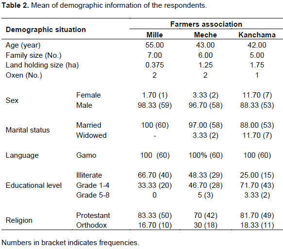
As shown in the Table 2 among the respondents, in Mille, Meche and Kanchama 98.33, 96.70 and 88.33%, respectively were male and the rest female. The religious composition, 83.33% of the respondents in Mille, 70% in Meche and 81.70% in Kanchama were protestant and the rest orthodox. In the case of educational status, 66.70% in Mille, 48.33% in Meche and 25% in Kanchama of the respondents are illiterate in each farmers association; the highest illiteracy level was recorded in Mille farmers’ Association; whereas the lowest was in Kanchama. As mentioned in Table 2, the number of oxen owned by farmers in the three farmers association was recorded as highest (2) in Mille whereas the lowest (1.00) was in Kanchama. The overall average recorded in the study area was (2). Community elders explained that oxen are most important animals in the area. In such a way that they are indicators of wealth, focus group discussion with elders revealed that they used to have large number of cattles some 30-40 years ago, however, due to climate change related factors such as, land degradation which have an impact on the livestock and their livelihood is now affected, in association with feed shortage, poor access to improved extension services, lack of improved cattle breeds and distance to marketing points and poor administrative mechanisms to restore the ecosystem was also the other factor which decreases the number of cattles in the area.
Analysis of farmer’s livelihoods and their relation with forest
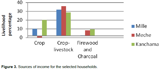
Most of the farmers depend on farm and off-farm activities to generate sufficient income in order to sustain their life (Figure 3 and Table 4). Forest is one of the resources on which most of the community depend to generate income and household usage. As shown in Figure 3, integration of crop and livestock system was the main source of income for the farmers; on the other hand, some of the farmers (15-25%) in Meche and Kanchama areas depend on selling of firewood and charcoal.
Major livelihood sources
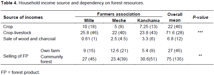
As respondents of households of different age groups indicated (Table 4) due to effect of deforestation, crop was sources of income for households. The interview result showed that, Mille, 10% and in Kanchama 7.25% of the respondents responded that crop production is the major income source for households. On the other hand, respondents in Mille, 25.8%, in Meche, 22% and in Kanchama 23.8% of the respondents indicated that crop-livestock production is the major source of household income (Table 4). The remaining 6.8% of the respondents in the study areas income source depend on sale of charcoal and firewood. From this result, it is possible to say that forest resources are one of the main income and livelihood sources to the local community in the area (Culas, 2006). The study areas are believed to represent the household socio-economic characteristics of the whole Farmers Associations in the Woreda, mixed crop-livestock farming systems are the major sources of household’s income; followed by crop production.The income generated from the above sources is used to cover other household expenses, government and social obligations such as clothing, school fees for children, payments of fertilizers and other. The variation is statistically significant (P<0.004) (Table 4). According to the results of the study, livestock production is considered for a source of income and survival. Ownership of oxen has the base for crop cultivation as the major tool for preparing land. Households who do not own oxen make an agreement with households who own oxen in exchange for labor. Some of the households traditionally lease out their land as a result of lack of oxen for land cultivation. The proportion of income generated in the study area is smaller than reports of central highlands of Ethiopia (NRoE, 2012).
Farmer’s access and utilization of forest
The result indicated that, households accessibility and utilization of forest resources did not change their income or livelihood assets (P<0.001). In the study area, some of the farmers’ association leaders explained that 40 years ago the main source for house construction and farming equipment was made from forest products but now they buy materials from the market which are not forest products.
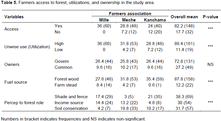
Most of the farmers have an access to forest resources for different purposes: fire wood, charcoal production, poles, local house construction, farming tools and household furniture (Table 5). However, each farmer’s association didn’t have an equal access. As indicated in Table 5, statistically significant difference (P<0.001) was observed between farmers association towards forest resource access. In Mille, about 36.00%, Meche 28.80% and 24.00% of the farmers have an accesses to forest resources (Table 5). About 82.20% of the farmers in the study sites have an access to forest resource but the remaining 17.77% of farmers who live at distance from the forest in Meche and Kanchama area did not have relatively less accesses to forest resource utilization for different purposes. These farmers instead use trees around home garden, and crop residues for cooking and source of light energy. This means that even though they are far form the forest they deplete the agroforestry vegetation near their home. Based on the statistical result, the observed accessibility and increased utilization of the remaining forest, is evident that there has been further deterioration of forests and other natural resources and contribute to increase in temperature.
Forests in the study site belong to the government. The Woreda and farmers association officials attempted to conserve the resource by restricting the inhabitants from using forest resources through awareness creation and punishment when necessary. However, some farmers feel that they not practically feel responsible. According to the respondents, about 72.80% of the forest land was owned by the government and the rest was the community forest.
According to the data taken from Keble and Woreda Agricultural offices in the previous 30-40 years, the area was covered by dense forest but at present, it was not more than 10 ha. This is attributed to the increase in population followed by high agriculture expansion. Most of the rural poor maintain diversified livelihood strategies, because they cannot obtain sufficient income from a single source to survive and to reduce risks. This is why the largest part of smallholder farmers is not really depending only on agriculture but also utilize forest products to increase their household income. As summarized in Table 4, majority of the households in the study area indicated that their main sources of household consumption of energy was forest wood (P<0.001). This finding was close to the situation in which forest wood is the main source of fuel for cooking in most part of Ethiopia (FAO, 2012). Figure 4a and b, shows that the source of energy in the study area is largely biomass energy, particularly trees. Fuel wood is used as energy for both cooking and lighting. Consequently, vast numbers of trees are cut each year, adding significantly to the rate of deforestation. Physical collection of fuel wood, which is the responsibility of women and children, is one of the factors affecting livelihoods negatively.
According to community elders, few of the households in the area depend on cow dung, crop residues, and dried woods of trees around home garden as fuel wood sources; the use of cow dung and crop residue for cooking purpose can depletes soil fertility and cause soil degradation in the area which results to low productivity. Some of the key informants mentioned that some years ago, the area was dominated by dense forests and different varieties of wild animals however, currently, only few trees are still standing and the area is severely degraded.
Perception of the role of forests and the importance of trees varies from community to community; in the Table 5, 17.4, 3 and 21% of the respondents in Mill, Meche and Kanchama, respectively, confirmed that forests are useful and important forest shading and fence; some households 14.4% in Mille, 13.2% in Meche and 4.8% in Kanchama indicated forest as source of income. The last groups explained that 4.2% in Mille, 19.8% in Meche and 10.2% in Kanchama perceived that forest was important in the conservation of soil. The sense of environmental protection is not well known by many household in the area. Even though there are development agents (DA) experts who have responsible of teaching the inhabitants about the environmental role of forests, the respondents in the study area have low perception of this role.
Forest degradation and conservation efforts
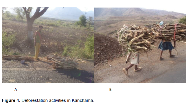
As indicated in Table 6, fire wood and charcoal production as a cause of deforestation was assessed in Mille 0.61%, Meche 2.5% and Kanchama 3.3%, the increasing human population from time to time in the area and the household’s different social and governmental obligations, such as children’s school fee, tax, to mention a few, exacerbated the rate of deforestation. However, household income was not covered; moreover, it resulted in excessive forest clearing for agricultural activities. In Kanchama, one of the communities elder explained that 30 years ago government policy towards awareness creation to the community was strong and consecutive especially from Woreda sector, however with time, the follow up gradually lessened which led to unsustainable utilization of forest resources for agricultural expansion by some illegal individuals. This is believed to be one of the major factors responsible for degradation of forest resources. It accounts for 27% in Mille, 33% in Meche and 31% in Kanchama. The overall mean of the three farmers association was 85%, and the traditional method of land cultivation is another factor which is responsible for the removal of the productive top-soil, hence a decline in land productivity, which has negative economic and environmental impacts. The most important cause of deforestation in all the study areas was found to be crop land expansion followed by cutting of trees for fuel wood and construction materials. The result showed that agricultural expansion took the largest share for forest destruction in the study areas (P<0.026). It is known that deforestation may expose the land to erosion which affects fertility of the soil, and also have significant impact on local and/or global climate.
Population increase have resulted in extensive forest clearing for agriculture, overgrazing by domestic animals, utilization for fuel wood, fodder and construction materials (Sands, 2006). New settlers are engaged in the conversion of forested area into crop production fields. According to the respondents, those who hold small land and those who totally do not have land were often involved in cutting trees for sale of firewood, for local house construction and for crop cultivation as income generation strategy. This condition which exists in the study area is similar to the causes at national level.
Most of the households (P<0.001) confirmed that the degradation of forest resources was a serious threat. During discussion with household heads, the occurrence of climate change in the area especially increase in temperature was one of the challenges which affected day to day activities of the people. According to the discussion, the effect of climatic change is accentuated by high population growth, land scarcity and depletion of forests resources. The household heads/members also mentioned that as population increases, there is expansion of crop land, which definitely leads to the forests depletion in the area.
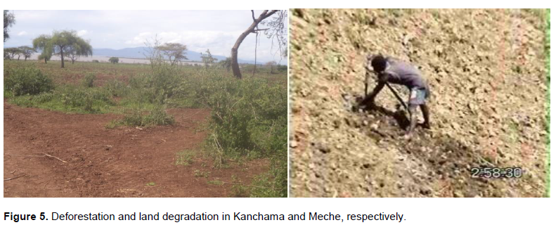
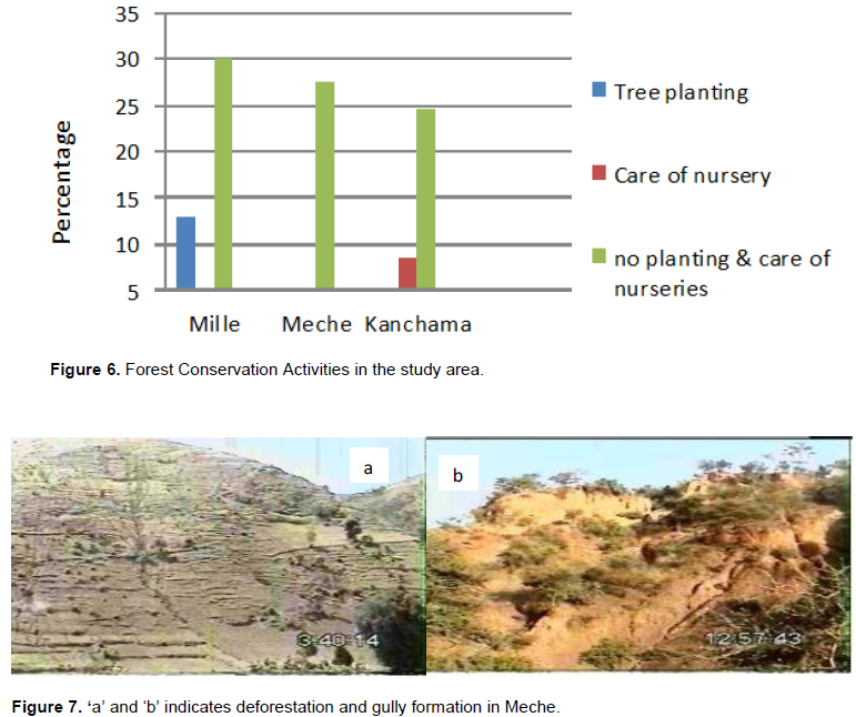
Forests are being cleared at an alarming rate for the purpose of acquiring more agricultural land for food production and to meet the demand for fuel wood and house construction materials, within less than forty years almost all of them have been cleared and leaving scattered patches of forest remains. The remaining natural forests are found in gorge escarpment and protected areas (millennium parks) (Figure 5a) of Meche and some mountain areas of Mille which are not physiographically suited for arable farming. Some of these forests do exist because they are inaccessible. The most common effects of deforestation are soil erosion, loss of soil fertility, increase in temperature, loss of biodiversity, rainfall variability and water and fuel wood scarcity. The result of this finding is in line with the work of Defaru (2006). The rate of deforestation at national level was 1% per hectare.
Forest conservation efforts
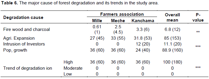
From the information gathered during field survey, it was evident that there was lack of awareness creation on the need to apply/utilize local knowledge in the conservation of forests, However, use of local knowledge in the study area alone cannot sustain the management of forests and environment unless it is supported by scientific methods and information (Figure 6). This is because, integration of both forms of knowledge create conducive condition to enhance environmental, ecological, social and economic sustainability. It was established that the selected household heads had low training opportunities in Mille (30.6%), Meche (27.6%) and Kanchama (24.6%) (Figure 7 and Table 7). Nevertheless, some of the respondentshad taken some training on tree planting (7.2%) and care of nursery (16 %). This finding was also in conformity with the result at national level of Ethiopia (NCS, 2012).
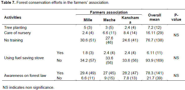
Respondents perception towards the laws and rules of forest resources indicated that the majority of the households in the study areas knows about the effects of deforestation and conservation practices through experience and from different sources of Knowledge (P<0.675) (Table 7). The community elders from each of the farmers associations share ideas and information that they had learned from their ancestors and villages. This is also a common practice in Ethiopia environmental conditions.
Focus group discussion and key informant perspectives on forest and livelihood activities
Focal group discussion with the planning team (a team
with twenty members comprising 50% of both genders who are in charge of leading the community level development activities and elders of the community) established that deforestation is the major causes of land degradation in the area as far as the change in vegetation cover is concerned, it was confirmed that within 30-40 years ago there has been a significant decrease in forest cover, with a decline in soil fertility as a result of soil erosion.
It was evident that the study area was close to Arba Minch town which aggravated the scale of demand for fire wood, charcoal and wood materials for construction, and farm implements. Furthermore, the expansion of wood markets in the farmers’ association and Arba Minch town also aggravated over utilization of forests. Lack of alternative energy sources is one of the major problems which enhance deforestation; this was due to high dependency of the majority of households on forest wood rather than the use of other alternative energy sources. According to the community leader’s perception, there was a significant difference in the land holding size among the households. The result of the study revealed that those households with relatively small land but large family size exhibited the tendency of getting involved in firewood selling and collection of forest wood for other different purposes. Among the drivers, population growth and agricultural expansion took the highest percentage in enhancing deforestation; this view of the group was in line with the result of household survey (Table 6). The results of the study show that majority the respondents use local knowledge and traditional conservation practices. Only few of the respondents use some modern conservation approaches/practices such as; tree planting and tree nursery management which is in line with the results of household survey. Although, the application and practice of modern soil and water conservation approaches/methods are low, within the last four and three years, there has been a mass movement/drive by the government to restore degraded land and watershed development, reforestation of degraded areas and gully protection activities such as check dam (a physical structure constructed in gullies to reduce flow of water, thereby reducing soil erosion). In addition, conservation education and awareness campaigns were being implemented. Despite agriculture being the main economic activity in the study area, for the last three decades, the food production has consistently continued to decline due to deforestation, soil erosion and loss of soil fertility.
As far as the participation of conservation partners and agencies is concerned, apart from government agencies, there was no active non-governmental organization (NGO) involved in conservation education. The presence of committed individuals, organization and the like in educating the local people on the importance of forest was important in minimizing the ongoing deforestation and consecutive deterioration of the forest land escape to take urgent and appropriate actions to the local contexts such as efforts to mobilize the local communities and all other concerned stakeholders to maintain and improve vegetation cover of the study area. In order to mitigate soil erosion and decline of soil fertility, improving forests cover which contributes to stop direct impact of rain fall intensity and increase water infiltration and decrease soils credibility through improving the soils resistance by means of improving soil structure through using compost and mulching (add crop residues to protect the soil from rain fall drop effect and improve soil fertility), is important in planting trees and practicing agro forestry in the study area. Finally, protection of the ecosystem was a precondition for leading agricultural production as creating social, economic and environmental sustainability. So, it was better to conserve and protect forests and other natural resources to ensure environmental sustainability and to get various benefits from forests resource. So, any responsible body, especially stakeholders like, government organizations, local institutions, NGOs, local investors should make decisions concerning the alleviation of deforestation and should create conducive environment promoting indigenous knowledge and scientific information to enhance environmental sustainability.
Contribution of different institutions towards forest conservation
Regarding the role of NGOs in minimizing the impact of deforestation on the livelihood of the community, often there has been a local doubt of the government and government institutions due to the past policies, legislation/laws and practices that placed foresters and local communities in conflict. For example, the group reported that there is no organization in the area which supports the conservation of forest resources. The key informants explained that if they were in the community, they would be able to facilitate/cause change at the local level by providing training, extension and advisory services, strengthening the conservation structures for food for work or payments; this will encourage and promote the rural community livelihood options.
The other role of NGO would be marketing and promotion of local community conservation initiatives as well as advocacy at the local, national and international levels (Arnold, 2001). External organizations such as NGOs can strengthen the positions of local actors (Stevenson, 1996; IPCC, 2003). And they may be as powerful as the state, but their power often originates from the money that they control (Stevenson, 1996; IPCC, 2003). From these perspectives, the discussion builds up by reporting that, this was the time for NGOs, and other organizations to look at the natural resources of the area.
The negative effect of deforestation on livelihoods of rural community is also reported by different individuals such as Kanel et al. (2004). The decreasing natural forest in the study area is a critical problem, has negatively affected the livelihoods of the people that depend on forest products and services for survival.