ABSTRACT
In this research, landform classification was performed based on the simple method developed by Weise, who used topographic position index (TPI) to classify the landform. TPI compares the elevation of each cell in a digital elevation model (DEM) to the mean elevation of a specified neighborhood around that cell. It can be calculated by a simple formula in different scales. After preparing landform map of the study area, soil sampling and physicochemical analysis were done in landforms which had the most repeatability in the region (plain and open slope). Results showed that transferring of parent material from the upper geomorphic surfaces and accumulating during the time are the main agents to form the plain and in case of open slope, moderately high slope changes with erodible parent materials that have varied over time, are the main parameters in landform formation.
Key words: Digital elevation model, geomorphic surfaces, geomorphology, landscape, topography.
In Iran, soil survey and land evaluation studies were initiated in 1953 in conformity with an agreement between the Food and Agriculture Organization of the United Nations (FAO) and the Government of Iran (Dewan, 1967; Mahler, 1970). The Iranian soil and water research institute has been involved in mapping the soils of Iran and classifying landforms for the last 65 years. However, the accuracy of traditional landform maps is very low (about 55%). To date, satellite imagery and different softwares have been used for landform classification studies.
Landform is a continuous surface covering the earth and results from the interplay of physical, chemical, and biological processes acting on the surface, functions as static boundary conditions for processes in geomorphology, hydrology, meteorology and other ?elds. Over past geological periods, different processes such as tectonic movements, erosion and sediment sequences have affected the evolution of landscapes. In arid and semi- arid conditions, climate change affects geomorphic processes that ultimatively shape landforms and landscapes (Bull, 1991). Erosion processes affected by climatic and geological factors coupled with human activities and parent material properties play a distinct role in development of steep landforms (vergari et al., 2012). Each year, many attempts have been performed around the world relating to the landform and relation between landform component and topographic elements.
Shary et al. (2002) have defined 12 types of slope curvature that can potentially be used for landform classification. Ballantine et al. (2005) classified landform based on slope and elevation parameters. MacMillan et al. (2000) produced a landform classification system based on quantitative digital variables. Also, many studies have been applied around the pedogenic and morphologic characteristics of landforms (Dill and Ludwig, 2008; Bishop, 2009; Tsai et al., 2010). Nowadays such approaches are computer based and rely on digital elevation models of various scales, sources, and kinds. Since computer power and a large amount of digital elevation data have become readily accessible, much more work has been done in geomorphometry and associated ?elds (Pike, 1995) often with Geographical Information Systems (GIS) as tools.
The principal objectives of this study are:
1. To classify landform based on topographic position index (TPI).
2. To study both parent material and slope changes in separated landforms.
Study area
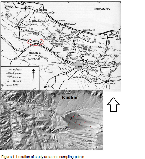
The study area is located between 36° 22' 14" and 36° 22' 51" N, and 49° 34' 58" and 49° 37' 13" E, approximately 500 ha area, in the Kouhin region, Qazvin Province, Iran (Figure 1). The mean annual precipitation and temperature at the site are 327 mm and 11.20°C, respectively. Rainfall season starts in late October and ends in June with, total annual average of 280 mm. Maximum rainfall events usually occur during April and May (Iran Meteorological Organization, 2015). Soil moisture and temperature regimes are Xeric and Mesic, respectively, according to Soil Survey Staff (2010). The study area has been created by old and high level terraces that include a clayey layer with conglomerate partly calcareous interlayer. Dominant landscapes of study area are plateaus and valleys. Plateau is the major landscape. Valleys cover the elongated parts among the plateaus and their parent materials are transferred from the highest part of region. Plain is the main landform in the study area. Dry farming and grassland are the major land uses in this area.
Preparing landform map of the study area
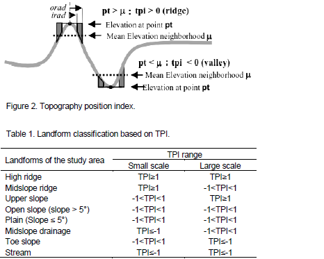
The creation of landform map was performed using topographic position and landform analysis. This algorithm is based upon the simple method developed by Weiss (2001) for generating a multi-scale TPI, classifying this index into slope position and landform types. TPI compares the elevation of each cell in a DEM to the mean elevation of a specified neighborhood around that cell. It is an inherently scale-dependent phenomenon and since the only input required is a digital elevation model, can be readily generated almost anywhere. It can be calculated by the following formula:
tpi<scalefactor> = int((dem - focalmean(dem, annulus, irad, orad)) + .5)
irad = inner radius of annulus in cells (Figure 2)
orad = outer radius of annulus in cells (Figure 2)
scalefactor = outer radius in map units
Landform category can be determined by classifying the landscape using TPI at different scales (Table 1). The combination of TPI values from different scales suggests various landform types.
Sampling and field studies
After identifying landforms of the study area, some soil pedons were sampled in landforms which were most abundant in the study area. Soil horizon samples were sieved (2 mm) for laboratory analysis. Soil carbonate content was determined by Bernard’s calcimeter method. Organic matter content was determined using the Walkley-Black dichromate acid oxidation method (Nelson and Sommers, 1996). Particle size analysis was carried out by the hydrometer method. Soil acidity (pH) was determined in 1:2.5 soil: water extracts. Soil salinity was assessed by determination of electrical conductivity in 1:5 soil water extract.
Figure 3 shows the landform map of the study area base on TPI. As shown, plain and open slope are most abundant in the study area, so as discussed in method, five soil pedons were sampled in each landform to examine the physicochemical properties and both roles of slope and parent materials in soil development (Table 2).
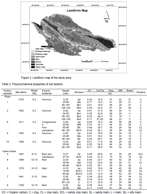
In the plain, except in the pedon 5, all pedons show a similar trend in percentage of clay, sand, silt and soil texture. Soil texture is clayey in whole horizons and gradual increase and decrease of clay and sand is seen from upper to lower horizons respectively. Carbonate contents also increase from upper to lower horizons that indicate the presence of active lime leaching processes. pedon 5 has more gravel in the lower horizons (surface horizon about 5% and lower horizons about 20%) that affect soil properties and cause a decrease in the amount of clay and change the soil texture from clay to clay loam. However the difference between pedon 5 and other pedons can be due to differences in parent material. A slight increase in the slope is seen in pedon 5 but the main factor in changing of its parent material is elevation. This pedon is located in a place that can’t be subject to any sediment transported from upstream, because compared to the surrounding geomorphic surfaces have a greater height. In plain, slope changes are low and the maximum is three percent, in this landform, parent material have been developed by sediments that have come from upper positions and deposited at depths over the time. It can be concluded that transferred parent material from upper geomorphic surfaces causing by weathering and deposition and accumulation processes at the lower positions have caused to form the permanent and relatively flat landforms. In open slope, the changes also can be seen as in the plain. Slope ranges vary from five to fifteen percent. This landform is located in back slope and shoulder position where is exposed on more erosion, leaching and transferring of material to the lower surfaces. Due to the relatively high slope steepness, the soils in the open slope are not deep because slope position has the greatest effect on soil depth and upper slope positions have shallower soils than lower (Weeb and Dowling, 2005). Parent material is marl in all pedons (except pedon 3) which is highly susceptible to erosion. So susceptibility of parent material to erosion and their weathering during the time have led to changes in topography in the study area which in turn have caused to form and differentiate the landforms.
The identi?cation of geomorphic surfaces will provide important information for understanding the landform formation and its link to tectonic processes that have occurred in the area (Tsai et al., 2010). Geomorphic surfaces are differentiated due to different parent material (Lark, 1999; Shaw et al., 2004) and classi?ed based on their local surface shape and slope gradient (McMillan and Shary, 2009). Differences in parent material may be inferred from differences in relief type, a break in slope or differences in drainage patterns (Udomsri, 2006). Together with geological and climatic factors as well as human impact, more local conditions, such as parent material properties, play a relevant role in the development of different slope landforms (Vergari et al., 2012). Possible differences in parent material characteristics and slope position discriminate landform types.
Separation and classification of landforms can be done based on parameters derived on digital elevation model. In this study, landforms have been separated based on topographic position index in which elevation and slope are the most important parameters. Investigation of physicochemical results and parameters such as elevation, parent material and slope percent in studied pedons showed that slope and parent material have the greatest effect in the formation of landform. But in the study area due to arid and semi- arid condition and low rate of weathering and leaching, the role of slope in landform formation is more obvious than parent material. In this study, investigate the role of slope coupled with parent material in area with high weathering and active geomorphic processes can be extended in future research.
The authors have not declared any conflict of interest.
REFERENCES
Ballantine JAC, Okin GS, Prentiss DE, Roberts DA (2005). Mapping North African landforms using continental scale unmixing of MODIS imagery. Remote Sensing Environ. 97:470–483.
Crossref |
|
|
Bishop MA (2009). A generic classification for the morphological and spatial complexity of volcanic landforms. Geomorphology. 111:104-109.
Crossref |
|
|
|
Bull WB (1991). Geomorphic response to climatic change. Oxford University Press, New York. |
|
|
|
Dewan ML (1967). Interim report to the government of Iran on soil survey and land classification for irrigation development in Iran. Publication No. 100. Reprinted by Soil Institute of Iran, Tehran, Iran |
|
|
Dill HG, Ludwig R (2008). Geomorphological-sedimentological studies of landform types and modern placer deposits in the savanna (southern Malawi). Science direct, Ore Geology Review. 33: 411-434.
Crossref |
|
|
MacMillan RA, Pettapiece WW, Nolan SC, Goddard TW (2000). A generic procedure for automatically segmenting landforms into landform elements using DEMs, heuristic rules and fuzzy logic. Fuzzy Sets and Systems 113:81–109.
Crossref |
|
|
|
McMillan RA, Shary P (2009). Landforms and landform elements in geomorphometry. Ch.9 in Hengl and Reuter. 2009 (q.v.). pp. 227–254. |
|
|
|
Mahler PJ (1970). Manual of land classification for irrigation. Publication No. 205. Soil Institute of Iran, Tehran, Iran. |
|
|
|
Nelson DW, Sommers LE (1996). Total carbon, organiccarbon, and organicmatter. In: Page, A.L. et al. (Eds.), Methods of soil analysis, Part 2, 2nd ed., Agronomy. 9. American Society of Agronomy. Madison. WI. pp. 961-1010. |
|
|
|
Pike RJ (1995). Geomorphometry - progress, practice, and prospect. Zeitschrift fuer Geomorphologie Supplementband. 101:221–238. |
|
|
Shary PA, Sharayab LS, Mitusov AV (2002). Fundamental quantitativemethods of land surface analysis. Geoderma. 107:1–43.
Crossref |
|
|
Shaw J N, West LT, Bosch DD, Truman CC, Leigh DS (2004). Parent material influence on soil distribution and genesis in a Paleudult and Kandiudult complex, southeastern USA, Elsevier, Catena. 57:157-174.
Crossref |
|
|
|
Soil Survey Staff (2010). Keys to Soil Taxonomy, United states. Department of Agriculture.11th ed. USDA-Natural Resources Conservation Service. Washington, DC. |
|
|
Tsai H, Hseu ZY, Huang ST, Huang WS, Chen ZS (2010). Pedogenic properties of surface deposits used as evidence for the type of landform formation of the Tadu tableland in central Taiwan. Geomorphology 114(4):590-600.
Crossref |
|
|
Lark RM (1999). Soil–landform relationships at within-field scales: an investigation using continuous classification. Geoderma 92:141-165.
Crossref |
|
|
|
Udomsri S (2006). Application of computer assisted geopedology to predictive soil mapping and its use in assessing soil erosion prone areas: a case study of DoiAngKhang, AngKhang Royal Agricultural Station, Thailand. MSC. Thesis, International Institute for Geo-Information Science and Earth Observation (ITC), Enschede, Netherlands. |
|
|
|
Vergari F, Seta M, Del Monte M, Barbieri M (2012). Badlands denudation "hot spots": The role of parent material properties on geomorphic processes in 20-years monitored sites of southern Tuscany (Italy). Science direct. Catena. 01757. |
|
|
Weeb AA, Dowling AJ (2005). Characterization of basaltic clay soils (Vertisols) from the Oxford land system in Central Queensland. Aust. J. soil Res. 28:841-856.
Crossref |
|
|
|
Weiss A (2001). Topographic Position and landforms Analysis.Poster presentation, ESRI user Conference, San Diego, C.A. |