ABSTRACT
Amidst positive effects of irrigation, there are some negative effects which potentially appear in irrigation areas. The most important are water erosion on sloping fields; caused by depreciating irrigation structures, resulting in siltation of water canals, growth of weeds, debris and other materials that has capacity to inhibit flow of water. This in turn affects surface and ground water quality. The soil physico-chemical property analysis reveals that soil samples taken from the irrigated field contains high phosphorus and potassium. Also, the levels of copper, total nitrogen and cadmium were above the acceptable limit in all locations where samples were collected compared to others. This may be due to accumulated residues of agro-chemicals used in the irrigated fields. The water physico-chemical properties demonstrated that potassium and chemical oxygen demand concentrations are beyond the permissible limit in almost all samples collected; even with water sample collected at the reservoir, which could be the resulting effect of fertilizers from the Bakolori Irrigation project. This can be inferred from the level of algae around the river banks. This paper presents result of soil samples, surface and ground water quality in Bakolori irrigation project and recommended measures for further action to preserve its physical resources.
Key words: Bakolori, irrigation, dam, surface water quality, ground water quality.
Bakolori is the name of a rural community in Sokoto State in North Western Nigeria. Sokoto State was one of the largest States in Nigeria until Kebbi and Zamfara States were carved out in 1991 and 1997 respectively (Mohammed, 2002). Given the abundant water resources in the country and its potential for increasing agricultural production in Nigeria, Federal Government of Nigeria established Sokoto Rima River Basin Development Authority (SRRBDA) to mitigate effects of persistent dry spells in the area, that results from too short rainy season that occur in the area. It was against this background that the Bakolori Irrigation project was commission. The original goal of the Bakolori irrigation project was to supply irrigation water to the estimated population of about forty to fifty thousand farm families in the project area. Construction work for Bakolori Irrigation Dam started on 5th June 1975 and was substantially completed and commission on 9th April, 1983. (Mohammed, 2002; Sokoto-Rima River Basin Development Authority, 1992).
Bakolori Reservoir is being fed by Rivers N’kaba and Tarka within Niger and join river Rima after entering Nigeria. The reservoir has a capacity of 450 million m3, lake area and length of 8000 Ha and 19 Km and a spillway discharge of 1650 m3/s at the time of construction in 1979. The dam had 450 million cubic meters water storage capacity, was substantially completed by 1983 but its current capacity is estimated at 351,010,027 m3 in 2013 (Sokoto-Rima River Basin Development Authority, 1992; Enplan Group, Nigeria, 2013; USAID, 2010; FAO, 2004).
The Bakolori Irrigation Scheme (BIP) is under the Sokoto-Rima River Basin Development Authority (SRRBDA) which is a Federal Government Agency. The Bakolori irrigation project covers three local government: Talata Mafara, Bakura and Maradun, commanding 23000 hectares; 65% irrigated by sprinkler system (15000 ha) while the gravity fed surface irrigation is used in the remaining 8,000 ha hosting more than 22,000 farmers located 110 km Southeast from Sokoto city. Presently the irrigation area under gravity is 7039 Ha for surface and converted sprinkler areas, while the non-irrigable area is 15,961 Ha which is mainly sprinkler and some surface area (Enplan Group, Nigeria, 2013; USAID, 2 010; Kebbeh et al., 2003). There are 3 Piezometric towers and 24 pumping Station which has depreciated to a state of disrepair over the last 20 years; about 3000 ha of the sprinkler irrigation scheme have been converted to surface irrigation through the provision of tube wells and intentional opening of lined canals. Therefore, a large section of the secondary canal needs rehabilitation (USAID, 2010; Kebbeh et al., 2003).
Several setbacks within the system were observed, among which are: Complete non-functioning of the hydro electric power station at the Dam. Failed sprinkler system originally covering 15000 hectares of which 3000 ha is now converted to surface irrigation through the use of tube wells. The failed dyke close to the rice area needs urgent intervention, de-silting of the drainage ditches across gravity fed areas needs to be done, because it has made the drainage ditches indistinguishable from adjacent farm lands; hence farmers now use drainage section for farming operations which was not the primary purpose which was rather to remove excess water from the system. Over-land flow is now a common site which is detrimental to crop-yield, keeping root zone too-moist for optimum performance (USAID, 2010).
Irrigation projects can fail if sediment load of water supply is higher than the capacity of irrigation canals to transport sediment; also siltation in canals shortens the active life mostly in tertiary canals as observed in the project. The gates of Bakolori Irrigation project and some sections of the secondary canals need to be rehabilitated. The drainage ditches are filled with sediments in specific areas around the system, hence increasing the salinity level of surrounding farmland which was the out-cry of farmers during consultation with farmers. The Dam, reservoir and irrigation works have suffered from lack of maintenance and currently there may be some degree of siltation of the reservoir, poorly drained areas within the command area; because of this development, the world Bank proposes to fund the rehabilitation of BIP, which has to be subjected to established Environmental procedures (USAID, 2010), pursuant to those procedures, activities that have potential for significant impact within a country require the preparation of an Environmental Assessment (EA) and subsequent approval of the EA and its recommendation to mitigate potential adverse effects. In view of these, there is need for an irrigation impact assessment (component of Environmental impact assessment) on the physico-chemical properties of farmland, surface and ground water quality, so as to ascertain the suitability in alternative uses in the project area, since there is no evidence to justify different urban and rural water quality standards ( Elizabeth et al., 2014).
Topography
The project site is nearly gentle and undulating, Bakolori lies between N12.51185° and E 6.1824° at 341 m above sea level in the North Western Nigeria, shares common boundary with Niger Republic in the North and Benin Republic in the West. The 15000 ha dedicated to sprinkler irrigation seems to be at higher elevation compared to the gravity fed irrigation system. However, due to the slightly varied slope of the canal, resulting sediment transport will pose no significant impacts to topography if sediment is removed from the drains.
Meteorological data for Bakolori irrigation project
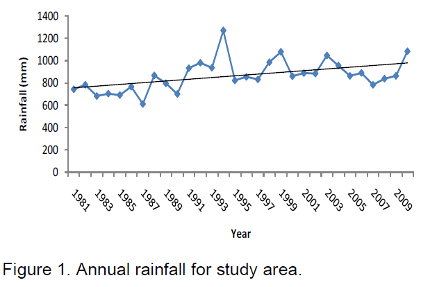
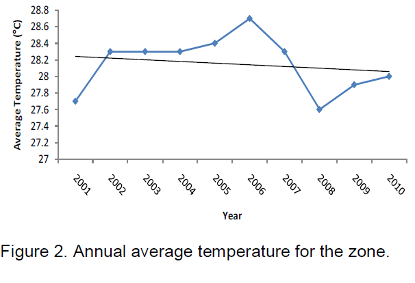
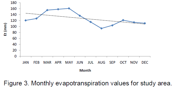
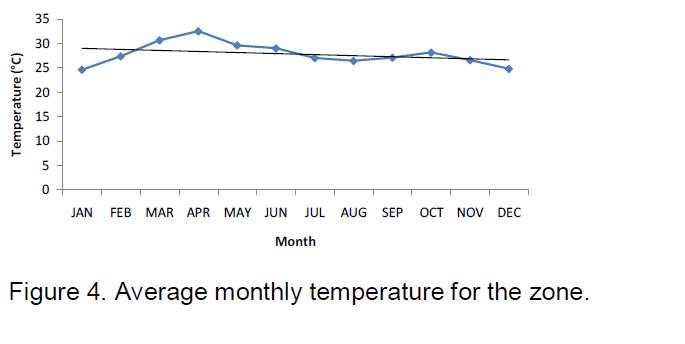
Mean annual rainfall of the project area shows a slow but consistent increase in trend from 1981 to 2009, ranging from 500 to 1300 mm with the last few years witnessing increasing annual rainfall as shown in Figure 1. Relative humidity ranges from 40 to 80% at what times of the year? however in the last decade as shown in Figure 2. Monthly evapotranspiration reaches its peak in March 155.2 mm and begins to drop reaching its minimum at the height of the rainy season in August (88.1 mm) as indicated in Figure 3. The highest temperatures of the air are between March and May as shown in Figure 4. Humidity-salinity bridge when a farmer
Soil
Sandy loam soils (terrace) are dominant on the slopes while the floodplains are dominated by black soils originally laterized (USAID, 2010). Salinity may occur as a result of the following in the project area:
1. Salts carried in the irrigation water which are liable to build up in the soil profile
2. Solutes applied to the soil as result of fertilizers, herbicides, pesticides etc
3. Salts already in the soil profile as a result of ground water associated with water logging which is very severe in arid areas
transfer from rainfed to irrigation (USAID, 2010; British Geological survey, 2003).
Soil samples
Comprehensive soil evaluation is essential for successful management of irrigated areas. The cultural practices and farming activities carried out by farmers in the project area has altered the physico-chemical properties of the soil which may be due to the inappropriate application of organic and inorganic fertilizer to the soil during (USAID, 2010).
Investigation of the top soil physical and chemical properties is essential to establish the important factors of water retention in the study area. The field work commenced 10th of November 2013. A reconnaissance survey of the area was carried out with the aid of the topographic map of the study location. Soil samples in two layers 0-15 cm for surface and 15-30 cm sub-surface were taken from several locations to make a total of thirty (30) samples as recommended by Kirda (1974) was collected. The pH was determined using glass electrode digital consort pH meter, exchangeable bases (Ca, K, and Na) were extracted with 1N NH4OAC buffed at pH 7. The Ca and Mg were determined using atomic absorption spectro photometer, K and Na were read on flame photometer (Thomas, 1982). Extractable micronutrients (Fe, Cu etc) were determined by double acid method, Total phosphorus was determined by the Bray II Method; cadmium was determined using spectrophotometer. Nitrogen was extracted by macro Kjedahl method (Carter, 1993).
Surface and ground water samples
High density PVC bottles were used for sampling. They were thoroughly cleaned by rinsing with 8N HNO3 and deionized water followed by repeated washing with water sample as suggested by De (1989). Water samples were collected at hand Dug well, deep bore hole and at Bakolori Mono pump area and at different sections of the supply canals, secondary, and tertiary channel where the flow seems to be turbulent and also at all the pump stations accessible to ascertain the status of the physico-Chemical properties of surface and ground water. Twenty (20) samples were taken to Zabson laboratory Services ltd accredited by the federal ministry of Environment, Nigeria.
Hence, acceptable Standard of Federal Ministry of Environment of Federal Republic of Nigeria were employed in the interpretation of the analysis of the study parameters.
Soil analysis
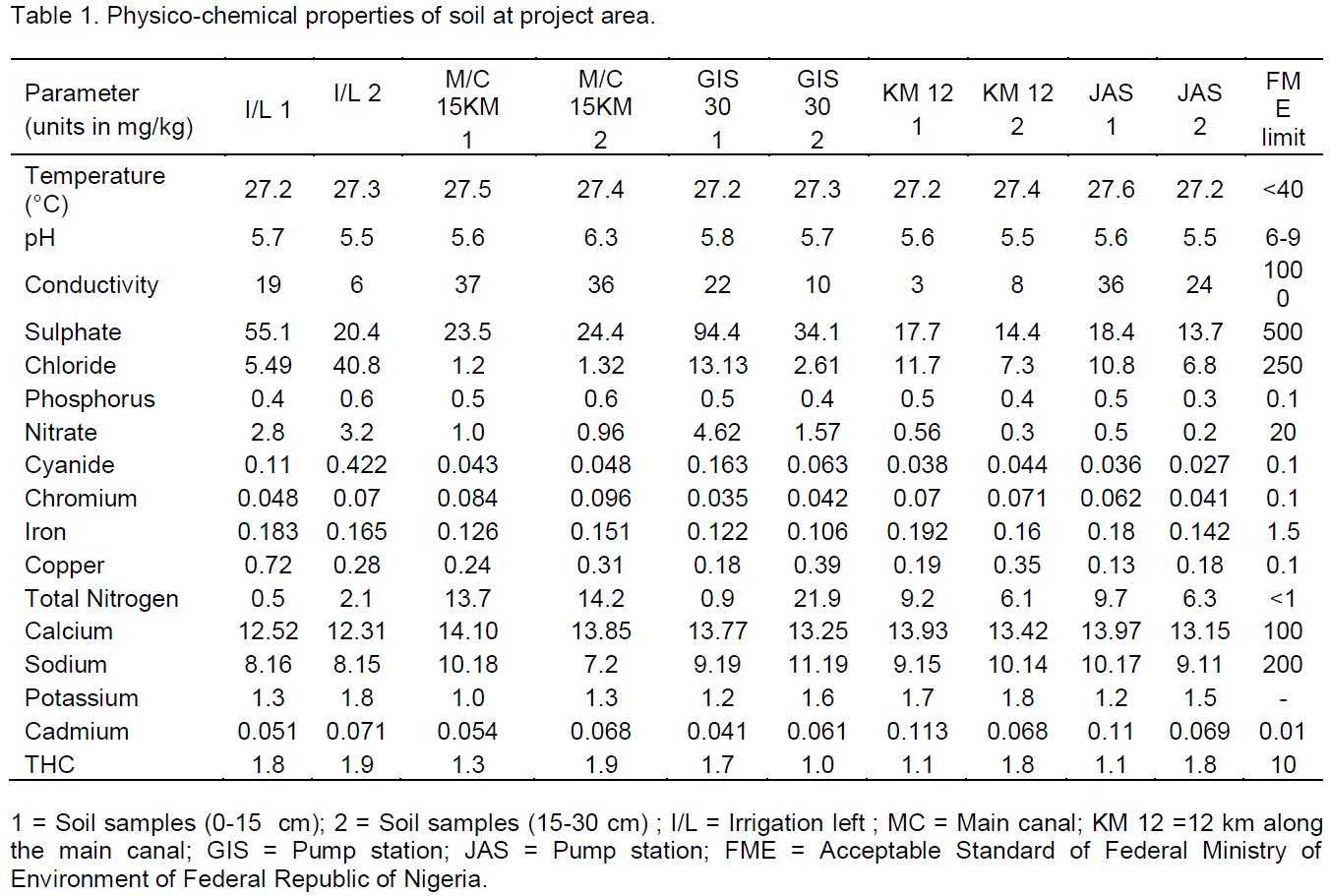
Colour of the soil sample range from grey to brown; majority of the soils observed were brown in colour with different shades. pH of the soil which depends on soil water ratio ranged between 5.5- 6.3 as shown in Table 1. The lowest pH value of 5.5 was found at irrigation left Farmland and also at 12 km of main canal and the maximum pH of 6.3 was found in subsoil (15-30 cm) of farmland at main canal. Electrical conductivity which is a measure of the amount of soluble salts present in the soil; the EC varied from 3-80 µS/cm which is within the acceptable limit. The lowest EC was found at farm land at 12 km (main canal) at the top soil (0-15 cm) and highest was noticed in the soil at Main canal 15 km from the dam. From samples of the soils collected as shown in Table 1, the sulphate concentration, chloride, phosphorus, nitrate, cyanide, chromium, iron calcium, sodium, potassium and total hydrocarbons present were within the acceptable limit which was in agreement with the report by USAID (2010). However, the levels of copper, total nitrogen and cadmium were above the acceptable limit in all the locations where samples were collected for the top (0-30 cm) soil and corresponding sub-soil (15-30 cm) which could be attributed to the use of agrochemicals and could be associated with the use of pesticide in the farms which could have be drained into ditches depending on their solubility in water. The level of available phosphorus, potassium and nitrogen caused by high rate of leaching with clayey texture developed from the river sediments because of cumulated effect of agro-chemicals applied. The level of phosphorus and potassium was beyond the acceptable limit which was at par with USAID, 2010 report.
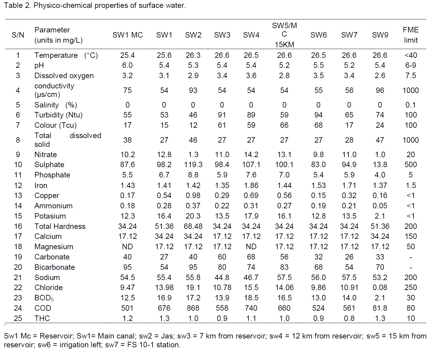
and total hydrocarbons were within the acceptable limit, however, as shown in Table 2 the iron concentration in Irrigation Left (SW6) and FS 10-1 (SW7) were beyond the permissible level which may be due to the fact that members of the community use the water from the canal to wash their motorcycles and bicycle, also some use to throw metallic object into the channel, it is therefore recommended that the channel should be clean and protected from been used by constructing a barricade to prevent members of the community from encroaching. Potassium and chemical oxygen demand concentrations are beyond the permissible limit in almost all the samples collected even with water sample collected at the reservoir which could be the resulting effect of fertilizers from the Bakolori Irrigation project which can be seen by the level of algae around the river banks as also reported by USAID (2010) . The elevated of level of potassium and phosphate in other points of collection may be because of the cumulative residual application of wrong dosage of agrochemicals and level of use of pesticide in farm land during crop production over the last 30 years which drained into the ditches. A water treatment plant is therefore needed at the Reservoir because of the high concentration of potassium and phosphate.
Water quality for ground water
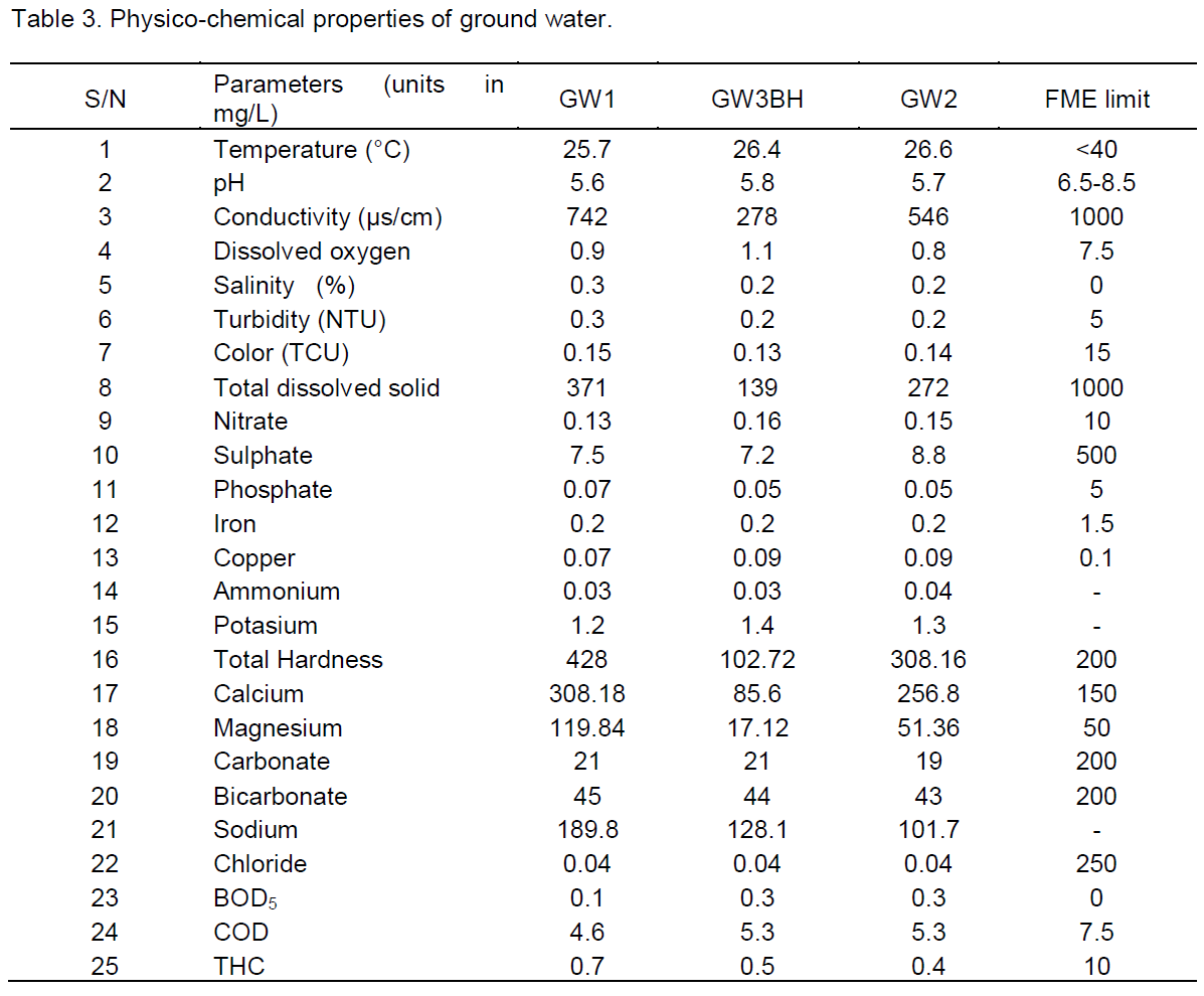
The ground water table has risen over the last 30 years, which occurs between 2 m and above in the project area. The degradation of surface and groundwater quality due to industrial and urban waste has been recognized for a long time (Mohammad et al., 2013), that is why farmers could use tube wells for areas formerly meant for sprinkler system. Groundwater samples were collected at a hand Dug well, deep bore hole and at Bakolori Mono pump and the physico-chemical properties were determined as shown in Table 3. The salinity, total hardness and biological oxygen demand concentration were all above the permissive level in the samples collected which is at par with the report of USAID (2010). Hence, water treatment plant should be connected to all the areas where water is harvested for consumption.
Dam safety appraisal
Bakolori Irrigation Reservoir is over 30 years and underutilized. The dam is not being monitored and very little exist about the status of the dam. Records of dams’ instrumentation stop shortly after the contractor left site and the instrument seems to be vandalized. Thus it was not possible to:
1. Determine the phreatic surface of seepage through dam embankments;
2. Assess any settlement of horizontal movement of dam structures;
3. Observe any unusual hydrostatic pressures particularly at the toes of the embankment;
4. Assess the functioning of the internal drainage system
Only the physical inspection and physical safety assessment were carried out, the concrete of the dam was founded on rock so there is low risk of internal erosion in the foundation; the upstream face of the dam is uniform and in good condition, there is no sign of settlement or cracking in the crest even though vegetation has taken root in places of the crest and the downstream shoulder it does not pose any threat to the embankment but could develop into substantial tree, the spillway appeared to be in excellent condition and also the downstream face is also protected from erosion.
Excavated soil from any region in the project area should not be used as amendment for soils in the farm plots, rather the excavated soils may be used to fill the borrow pits in the project area. Water monitoring of the Sokoto and Bobo River within the project area after the drainage ditches have been de-silted should be monitored, status of chemicals and nutrients entering the river should be ascertained. Regular monitoring of the physical and chemical properties of the water should be done; its frequency is a function of the silt-build up. Members of the communities within the project area should be advised to stop taking their bath, washing clothes and swimming inside the water course (canal).
The authors have not declared any conflict of interest.
REFERENCES
|
British Geological Survey (2003). Ground Water Quality: Nigeria. |
|
|
|
Carter MR (1993). Soil Sampling and methods of Analysis. Canadian Society of Soil science Lewis Publishers. London. P. 823. |
|
|
|
De AK (1989). Environnemental Chemistry. Wiley Eastern Limited, New Delhi, India. pp. 42-43. |
|
|
|
Elizabeth C, Robert B, Jim W, Stephen A, Rifat H, Jamie B (2014). Examining the Influence of Urban Definition When Assessing Relative Safety of Drinking Water in Nigeria. Science of the Total Environment 490:3011-3012. |
|
|
|
Enplan Group, Nigeria (2013). Feasibility studies and design for irrigation and water resources management investment in Sokoto-Rima Basin in Northern Nigeria. Inception Report (Draft). Federal Government of Nigeria, Federal Ministry of Water Resources. FMWR /WB/IR/QCBS/12/1. |
|
|
|
FAO (2004). Review of the Public Irrigation Sector in Nigeria. Draft Status Report, Federal Ministry of Water Resources. Enplan Group.009/TF/NIR/CPA/27277-2002/TCOT |
|
|
|
Kebbeh M, Haefele S, Fagade SO (2003). Challenges and Opportunities for Improving Irrigated Rice productivity in Nigeria. West Africa Rice Development Association, Abidjan-Cote d'Ivoire.
View
|
|
|
|
Kirda C (1974). Assessment of Irrigation Water Quality. CIHEAM-options Mediterranean. |
|
|
|
Mohammed KY (2002) Development and challenges of Bakolori irrigation project in Sokoto State, Nigeria. Nordic J. Afr. Stud. 11(3):411-430. |
|
|
Mohammad V, Seyyed MM, Reza V, Ehsan R (2013). Deal with environmental challenges in civil and energy engineering projects using a new technology. J. Civil. Environ. Eng. 3:127.
Crossref |
|
|
|
Sokoto-Rima River Basin Development Authority (1992). Annual Report. |
|
|
|
Thomas GW (1982). Exchangeable Cation. In A1 page R.H Moller and D.R/Keeney (eds); Methods of Soil Analysis part Second Edition. America Society of Agronomy, Madison pp. 157-161. |
|
|
|
USAID (2010). Environmental Assessment Irrigation Rehabilitation Program MARKETS. |