Full Length Research Paper

ABSTRACT
Facing up with the effects of climate change, increasing human population, reduction of natural resources, and degradation of soils the agricultural sector has the challenge of meeting the world's demand for food. In this scenario, the interest of scientific communities for the use of Unmanned Aerial Vehicles (UAV) in the agricultural sector has increased in recent years. The aim of this article is to provide a global view on how scientific communities interact and identify gaps and opportunities in research of UAV in the agricultural sector. The study reviewed the scientific publications of the Web of Science from 2000 to 2018 using a data-driven approach. According to specific search terms, the most relevant publications have been downloaded from specialized database and they have been analyzed from the point of view of bibliographic data through the VOSviewer software. Examining the network graphic of citations to describe the interaction and processing the terms of the titles and abstracts with the data mining techniques, in order to identify current trends research and gaps in the literature were identified. Scientific community is working to design technological platforms to support agriculture actors for making data-based decision schemes, where computational algorithms and visualization techniques are applied.
Key words: Agricultural innovation, technology applications, unmanned aerial vehicles (UAV), drones.
INTRODUCTION
Since 2011, Unmanned Aerial Vehicles (UAV), also called drones, represent a breakthrough for the agricultural sector, because they are more affordable and easier to use (Frankelius et al., 2017). Nowadays, practical applications for UAV are expanding faster than ever in the agricultural sector.
In contrast to the difficult and cost to obtain satellite imagery or conventional airborne data, recollect aerial images with UAV equipped with GPS and digital cameras mode is cheaper and faster to do it. UAV represents one of the most important emergent technological tools, recognizes to their flexibility of use as well increasing applicability.
Facing the challenges posed by the effects of climate change, increase in world population, decrease in natural resources and degradation of agricultural land (Bayala et al., 2017; Singh and Singh, 2017; Zilberman et al., 2018), the UAVs allow the agricultural innovation about planning and monitoring processes to strengthen food production. UAVs provide the opportunity to improve crop monitoring, soil, and field analysis. Using these aerial platforms, the monitoring task is developed in an easier, closer and precise way, reducing cost and time (Handique et al., 2017; Krienke et al., 2017, Hunt et al., 2018; Khan et al., 2018). With this innovation, it is possible to construct surface maps and digital models of crops (Hovhannisyan et al., 2018; Huuskonen and Oksanen, 2018).
Currently, some of the most common applications of UAV are: a) acquisition of crop data (using different types of cameras); b) monitoring of crop growth; c) sprayer (fertilizers, herbicides and pesticides); and d) capture of images to create 3D models. Based on a global report published by PricewaterhouseCoopers (PwC), the size of the UAV market in agriculture is estimated at $32.4 billion US dollars (Mazur et al., 2016). An important issue is considering that the UAV technology will allow for individual farms to be highly data driven, which will lead to increased productivity and yields.
UAV platforms are using within the agricultural ecosystems for data assimilation and monitoring agricultural production systems (Domingues et al., 2017). Low-cost aerial platforms collect images of crops to support discrimination of plants species (Hadique et al., 2017; Oldeland et al., 2017), monitoring based on phenotypes (Burkart et al., 2018) and diagnostic of water status (Martínez et al., 2017), determine the health status (Khan et al., 2018), calculate nitrogen and other nutriments level (Krienke et al., 2017), and identify pathogens (West et al., 2017).
In this context, it is relevant to know the works related to the use of UAV in the agricultural sector reported in the literature to identify the research fields that are being followed by the research communities. Additionally, to identify opportunities to develop new research and innovation projects in agricultural production systems is important know the characteristics, conditions, and benefits of the UAV applications in agriculture. The aim of this review of scientific literature was to provide a global view by (1) analyzing historical development and recent trends, (2) investigating through citation networks how scientific communities interact with each other and, ultimately, (3) identify gaps and opportunities in the scientific literature for research and application of UAV in the agricultural sector.
MATERIALS AND METHODS
Data selection
As source of data, the study considered scientific publications from Web of Science (WoS) of Thomson Reuters (Thomson, 2018). In an exploration test, the study found that publications prior to 2000 related to this topic of interest are minimal and not directly linked to current UAV platforms. A particular set of publications that correspond to the period between the years 2000 and 2018 were selected, analyzed, and classified. Logical combinations of search terms were used to collect relevant works from UAV as an innovation in the agricultural sector. For UAV applications in agricultura, the terms applied were: (agriculture*AND (unmanned aerial vehicle OR unmanned aerial system OR uav OR uas).
Search terms applied to collect papers related with the application of UAV in the monitoring and control of crops were: (crop* AND (unmanned aerial vehicle OR unmanned aerial system OR uav OR uas)). Finally, to include drone applications in the agricultural sector and in crop monitoring, the search terms considered were: (drone* AND (agriculture* OR crop*). Using these search terms, result was a set of 704 publications. The information of each publication was downloaded considering: title, abstract, author, citations, keywords, and year as a text file delimited by tabs for further processing with VOSviewer.
Data driven approach
Given that the agricultural sector and UAV have experienced a growing interaction of large number of communities, it is a challenge to carry out the holistic review. Instead, the VOSviewer software (available at www.vosviewer.com) was used, which is a free text mining software used to generate bibliometric maps of scientific fields (Van Eck and Waltman, 2013). Taking advantage of the bibliographic data and using the software functionality, the workflow of analysis was divided into data recovery, pre-processing, network extraction, normalization, mapping analysis and visualization. In the pre-processing test the temporal trends in the 704 publications retrieved from 2000 to 2018, geographical source and most used journals were analyzed.
A second analysis was performed for three techniques based in natural language processing algorithm used to generate the results applying the predefined thesaurus file to delete unrelated words and combined words. The first technique was based on keyword analysis producing a scientific map which was used to identify the scientific communities with a least of 15 occurrences. As a second technique, the citation information was employed to look into the interaction between authors and research communities. Finally, this work took advantage of data mining tools and Kernel algorithm (Perianes-Rodriguez et al., 2016), which was applied in the analysis of titles and abstracts of the considered set of research documents from 2014 to 2018 to investigate trends and identify gaps in the literature.
RESULTS AND DISCUSSION
Descriptive analysis
A set of 704 papers has been identified, which include UAV research and applications in the agricultural sector. The number of publications retrieved from 2000 to 2013 were 116, representing the historical development period. From 2014 to 2018, the number of publications has been increasing, 588 research works were published.
Increase in the amount of works published since 2014 relates to the reduction of costs of sensors, communication systems, and aerial platforms.
Additionally, the UAV camera systems have a larger spatial resolution increasing the capabilities to get better information about the agricultural environment. This situation allowed to scientific community access to different UAV platforms: fixed wing like Viewer Elimco and mX-Sight; multi-rotor as OktoKopter and Vario Benzin, and some cameras solutions as Micro-Hyperspec VNIR and MCA-6 Tetracam (Turner et al., 2012; Zarco-Tejada et al., 2013a, b).
Geographical analysis described that 94.3% of scientific works were published by researchers from 10 countries: 26.7% from USA (188), 16.9% from Spain (119), 14.6% from China (103), 7.2% from Germany (51), 5.9% from Australia (42), 5.8% from Italy (41), 4.8% from Brazil (34), 4.5% from India (32), 4.1% from France (29), and 3.5% from Netherlands (25).
In total, 271 sources of publications (journals and conferences) were identified. From obtained data, the advanced publications were reported in journals and a 15 group sources were responsible for 47% of all publications, while the other 256 sources were responsible for the remaining 53%. In the knowledge field under study, a significant amount of paper has been published in journals as Remote Sensing (12%), Sensors (5%), Precision Agriculture (5%), Computers and Electronics in Agriculture (4%), and International Journal of Remote Sensing (4%).
Historical development and interaction
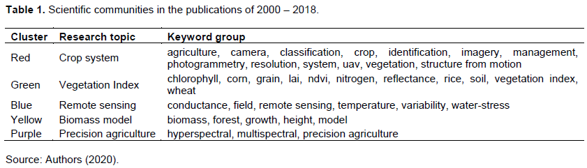
To analyze the historical interaction of keywords, 3,563 keywords from the publications compiled by using VOSviewer were extracted. Of these, 38 occurred at least 15 times and were filtered through the thesaurus files to obtain the 25 most relevant keywords. Figure 1 presents the resulting scientific landscape considering the set of keywords, grouped by co-occurrences of the keywords of the documents. Five groups were identified and marked with different colors. Table 1 summarizes these groups; each group was named arbitrary (research topic) based on the observed keywords. For example, the red cluster labeled as Crop System include the keywords related to Crop. Green, blue, yellow, and purple groups were nominated Vegetation Index, Remote Sensing, Biomass Model, and Precision Agriculture, respectively.
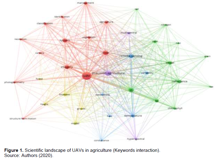
As shown in Figure 1, it is clear that five constituted groups have a uniform distribution and the distances separating them were not large. The UAV keyword was the largest sphere, and it is at the center, indicating research collaborations between UAV with the communities working at Crop System (red), Vegetation Index (green), Precision Agriculture (purple), Remote Sensing (blue), and Biomass Model (yellow).
The keywords in the red cluster summarize the crop management systems developed in this group. First, the keywords UAV and crop occurred 375 and 107 times respectively, indicating the interest of the community to investigate the application of UAV in crops. Researchers have been interested in the issues of imagery (98), system (98), agriculture (53), management (51), classification (41), vegetation (37), identification (31), and photogrammetry (31). The community has been working on systems based on photogrammetry of agricultural fields, to identify and classify the vegetation growing in the fields with the purpose of strengthening the handling and management of production systems.
In the green cluster, the researchers interest was focused on vegetation indexes calculate from the aerial images collected by UAV in low altitude flying. The occurrence of the keywords chlorophyll (35), lai (69), ndvi (17), nitrogen (20), and reflectance (71) show that the scientific community has used these properties for the study of vegetable health and crop sanity. The keywords lai (Leaf Area Index) and ndvi (Normalized Difference Vegetation Index) occurred 69 and 17 times respectively, which were the vegetation index most used. Also, the work of the community has been addressed to study cereals: corn (43), grain (17), rice (15), and wheat (77) crops. Interest of researchers in the purple cluster, Precision Agriculture, was related to the keywords precision agriculture (168), hyperspectral (32), and multispectral (32). These terms include UAVs application to collect hyperspectral and multispectral images to describe different features of the crops that can determine the state of health, water levels and nutrients.
In the cluster of Remote Sensing (blue) the occurrence of the keywords temperature (56), conductance (17) and water-stress (19) indicate that the community's interest to measure, transmit, and even control a vast amount of variables and properties involved in crops. Besides, the keyword variability (39) describes the tendency of remote sensing research to study variations in the properties of crops during different stages of development. Keywords occurred in the yellow cluster include the interest of the research community to build models (40) of biomass (44) to describe the growth (23) and development (height, 23) of the vegetation (forest, 16) in agricultural production systems.
Bibliometric analysis
Bibliometric indicators of the analyzed scientific works included in the WoS citation report show that the total number of articles was 704, the total number of times cited was 9,336 and that the average number of citations per investigation was 13.26. Furthermore, the h-index of Hirsch (2005) allows to measure the quality of scientific works (based on the number of citations received) and the quantity of scientific production. The h-index of the whole set of publications was 51 and this represents that in the studied group there were 51 research works that have received at least 51 citations each. Table 2 presents the 10 scientific articles with the highest number of citations from the considered set of documents. As noted, the research topics that address the work were related to the techniques of image processing for crop monitoring and detection of water stress.
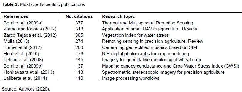
The most cited works deal with theoretical developments and conceptual references, conforming the historical development of the 2007 - 2014 periods. Also, other authors have researched the evolution of aerial platforms equipped with TIR (Thermal Infrared) sensors, multispectral cameras, and Global Positioning System (GPS). These technological platforms were used to analyze issues related to use of water and the estimation of vegetation index. In the same period, the first UAV sprayer systems for the application of chemical treatments on crops were reported (Huang et al., 2009; Zhu et al., 2010). From density scientific citation map of the set of publications (Figure 2), only works having at least 51 citations in correspondence with the h-index of the set were included. Some communities of authors were identified in the analyzed set.
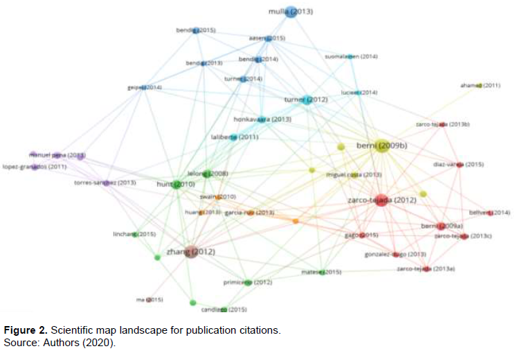
A group of articles show the interest of the scientific community in the thermal and multispectral images application to get the vegetation indexes to determine the water stress in crops, yellow cluster.
Works published by the concerned community in application of image processing on agricultural sector, aquamarine cluster; and they have been expanded by other authors, where the construction of surface crop models were considerate.
Moreover, there were works reported by the scientific community developing strategies involving the UAV platforms application as a tool for precision agriculture techniques, particularly in monitoring and tracking tasks on crops, green cluster. Finally, the group exploring methods and technology based on the UAV applied to weeds detection and site mapping in crop fields has released, purple cluster.
Research trends
To analyze the research topics included in titles and abstracts of the works considered in the set of publications from 2014 to 2018. Thus, 17,805 terms have been extracted from the publications by using VOS viewer. Of these terms, 95 occurred at least 30 times. The resulting scientific landscape is presented in Figure 3 where the 50 most relevant terms were included. Three clusters of topics were identified, and then those groups of research works belonging to each one of the groups were considered.
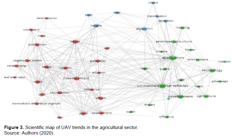
Red cluster include the terms measurement (135), value (124), stage (95), estimation (93), season (85), and vegetation index (82). Existing proximity to terms effect (104), assessment (90), yield (103), and plot (86) describe the interest of scientific groups in the estimation of vegetation index in plots into stage in seasons of crops to measurement yields, estimations, effects, differences, relationship, and potential of biological control treatments, health vegetal monitoring, water stress vigilance, and nutrients provided.
Occurrences of the terms algorithm (105), detection (76), height (94), map (71), pixel (63), classification (55), and object (46) constitute the blue cluster. It describes that the research works have been focused to develop computational and statistical algorithms to crop maps construction useful to plants classification and object detection at field scale. Aerial images processing aims identification of crop interest features related to spatial location and natural resource in agroecosystem.
Green cluster include the terms application (201), unmanned aerial vehicles (197), development (137), technology (125), and precision agriculture (84) that describing the interest to implement different precision agriculture strategies to applying UAV into agricultural sector. Technological strategies focused on the impact (53), efficiency (67), quality (65), and advantage (46) describe research groups interest into low-cost (39) UAV application for development competitive advantage to farmers in the regional scale.
Interaction between Red, Blue, and Green clusters represent the scientific interest to application of UAV into farm production systems.
Considering the performed exploratory analysis, two periods can be defined as: historical development (2000-2013) and the current trends (2014 - 2018), with significant differences in the quantity of published works.
Scientific landscape of keywords identifies five communities (Table 1 has a uniform distribution centered on the term UAV and with small distances separating them, Figure 1). A recent trend is the design of agricultural management systems guided by data for smallholders (Maru et al., 2018), and it can be strengthened with the integration of strategies, techniques, and tools coming from the five described scientific communities.
Citation scientific map presents some communities of authors (Figure 2). The most cited research works consider the processing of digital images collected by UAVs as a fundamental tool to get vegetation index. An opportunity in the monitoring and evaluation of crop maps with plant disease detection (Lammoglia et al., 2018; Thomas et al., 2018) to integrate with risk management strategies for help to producers in the generation of guided action plans to solve these undesired effects based on collected data.
In the scientific landscape of research topics, three cluster were identified, then the set of documents belonging to each group was analyzed (Figure 3). It shows that the scientific community is currently interested in the existing correlation of vegetation index with the stages of crop development (Burkart at al., 2018), studying the spatial variability at the plot scale, and the relation of both with the treatments applied to the crops to evaluate their potential and measure their effects.
Recent trends promote active participation of agricultural producers in the design of technological solutions, design and implementation of monitoring, and analysis strategies at the plot level (Pallottino et al., 2018). Integration of low-cost technologies (Barrero and Perdomo, 2018; Schut et al., 2018), expansion of solutions with comprehensive data analytics capabilities (Lary et al., 2018), allows the configuration of software services with visualization technologies to strengthen decision-making based on data (Kamilaris and Prenafeta-Boldú, 2018; Rupnik et al., 2018).
On the other hand, a data-driven approach used in this work depends on the quality of data collection. Although, the set of considered publication has been built in a careful way through logical combinations of search terms, it was a challenge to ensure that all relevant paper was considered, because there could be exist alternative research terms. This study was limited to the search in the WoS database, whose search engine only explore and find matches in the title, abstract, and keywords of paper, without considering the main text. Therefore, a higher level systematic and inclusive approach is required in order to build a richer collection of publications, generating more precise data. However, a significant change in results and conclusions is not anticipated.
CONCLUSIONS
In this review, data-based method to search and analyze scientific publications was used to identify gaps in the literature and research opportunities in the application of UAVs in the agricultural sector. The relationship between the two fields of research was visualized through scientific maps of keywords, citations, and research topics.
Keywords analysis indicated that the scientific community has focused it is interest in the use of UAV to build technological tools that arise from collaborations between the areas of Crop System, Vegetation Index, Precision Agriculture, Remote Sensing, and Biomass Model. From the analysis of citations of the documents, communities of authors have been identified and they were interested in: (a) the application of thermal and multispectral images for the quantification of plant index and detection of water stress; (b) image processing techniques for the construction of surface models; (c) use of digital images for crop monitoring; and, (d) image analysis for the detection of weeds.
In analysis of data mining of scientific documents for the co-occurrence of research topics, the study found that the application of UAV in agricultural crops is an issue of interest to the scientific community, who was addressing the producer problems related to the costs and production processes at parcel scale. Analysis of the vegetation index, stages of crop development, and the variability in the crop field about the agricultural cycles and the effects of the treatments, were also performed.
Finally, this study allowed to identify trends in research topics in agricultural sector to use UAV. In contrast, terms about cost effectiveness, policy and management, UAV adoption, pollination process, pesticide application, and coordination of precision agriculture resources are not frequently present, underlining potential research gaps or under explored topics that are yet required to be filled.Application of the UAV in agricultural sector are expanding rapidly. To determine the appropriate strategies and UAV technologies for agricultural system and environmental conditions it is important to systematically and continuously conduct comparative studies to guide sustainable agricultural development.
CONFLICT OF INTERESTS
The authors have not declared any conflict of interests.
REFERENCES
|
Barrero O, Perdomo SA (2018). RGB and multispectral UAV image fusion for Gramineae weed detection in rice fields. Precision Agriculture pp. 1-14. |
|
|
Bayala J, Zougmoré R, Dayamba SD, Olivier A (2017). Editorial for the Thematic Series in Agriculture and Food Security: Climate-Smart Agriculture Technologies in West Africa: learning from the ground AR4D experiences. Agriculture and Food Security 6(1):40. |
|
|
Berni J, Zarco-Tejada PJ, Sepulcre-Cantó G, Fereres E, Villalobos F (2009a). Mapping canopy conductance and CWSI in olive orchards using high resolution thermal remote sensing imagery. Remote Sensing of Environment 113(11):2380-2388. |
|
|
Berni J, Zarco-Tejada PJ, Suarez L, Fereres E (2009b). Thermal and Narrowband Multispectral Remote Sensing for Vegetation Monitoring From an Unmanned Aerial Vehicle. IEEE Transactions on Geoscience and Remote Sensing 47(3):722-738. |
|
|
Burkart A, Hecht VL, Kraska T, Rascher U (2018). Phenological analysis of unmanned aerial vehicle based time series of barley imagery with high temporal resolution. Precision Agriculture 19(1):134-146. |
|
|
Domingues FM, Bartholomeus H, Van Apeldoorn D, Suomalainen J, Kooistra L (2017). Intercomparison of Unmanned Aerial Vehicle and Ground-Based Narrow Band Spectrometers Applied to Crop Trait Monitoring in Organic Potato Production. Sensors 17(6):1428. |
|
|
Frankelius P, Norman C, Johansen K (2017). Agricultural Innovation and the Role of Institutions: Lessons from the Game of Drones. Journal of Agricultural and Environmental Ethics pp. 1-27. |
|
|
Handique BK, Khan AQ, Goswami C, Prashnani M, Gupta C, Raju PLN (2017). Crop Discrimination Using Multispectral Sensor Onboard Unmanned Aerial Vehicle. Proceedings of the National Academy of Sciences, India Section A: Physical Sciences 87(4):713-719. |
|
|
Hirsch JE (2005). An index to quantify an individual's scientific research output. Proceedings of the National Academy of Sciences of the United States of America 102(46):16569-16572. |
|
|
Honkavaara E, Saari H, Kaivosoja J, Pölönen I, Hakala T, Litkey P, Pesonen L (2013). Processing and Assessment of Spectrometric, Stereoscopic Imagery Collected Using a Lightweight UAV Spectral Camera for Precision Agriculture. Remote Sensing 5(10):5006-5039. |
|
|
Hovhannisyan T, Efendyan P, Vardanyan M (2018). Creation of a digital model of fields with application of DJI phantom 3 drone and the opportunities of its utilization in agriculture. Annals of Agrarian Science 16(2):177-180. |
|
|
Huang Y, Hoffmann WC, Lan Y, Wu W, Fritz BK (2009). Development of a Spray System for an Unmanned Aerial Vehicle Platform. Applied Engineering in Agriculture 25(6):803-809. |
|
|
Hunt ER, Hively WD, Fujikawa S, Linden D, Daughtry CS, McCarty G, McCarty GW (2010). Acquisition of NIR-Green-Blue Digital Photographs from Unmanned Aircraft for Crop Monitoring. Remote Sensing 2(1):290-305. |
|
|
Hunt ER, Horneck DA, Spinelli CB , Turner RW, Bruce AE, Gadler DJ, Brungardt JJ, Hamm PB (2018). Monitoring nitrogen status of potatoes using small unmanned aerial vehicles. Precision Agriculture 19(2):314-333. |
|
|
Huuskonen J, Oksanen T (2018). Soil sampling with drones and augmented reality in precision agriculture. Computers and Electronics in Agriculture 154:25-35. |
|
|
Kamilaris A, Prenafeta-Boldú FX (2018). Deep learning in agriculture: A survey. Computers and Electronics in Agriculture 147:70-90. |
|
|
Khan Z, Rahimi-Eichi V, Haefele S, Garnett T, Miklavcic SJ (2018). Estimation of vegetation indices for high-throughput phenotyping of wheat using aerial imaging. Plant Methods 14(1):20. |
|
|
Krienke B, Ferguson RB, Schlemmer M, Holland K, Marx D, Eskridge K (2017). Using an unmanned aerial vehicle to evaluate nitrogen variability and height effect with an active crop canopy sensor. Precision Agriculture 18(6):900-915. |
|
|
Laliberte AS, Goforth MA, Steele CM, Rango A, Goforth MA, Rango A (2011). Multispectral Remote Sensing from Unmanned Aircraft: Image Processing Workflows and Applications for Rangeland Environments. Remote Sensing 3(11):2529-2551. |
|
|
Lammoglia SK, Brun F, Quemar T, Moeys J, Barriuso E, Gabrielle B, Mamy L (2018). Modelling pesticides leaching in cropping systems: Effect of uncertainties in climate, agricultural practices, soil and pesticide properties. Environmental Modelling and Software. |
|
|
Lary DJ, Zewdie GK, Liu X, Wu D, Levetin E, Allee RJ, Aurin D (2018). Machine Learning Applications for Earth Observation. In Earth Observation Open Science and Innovation (pp. 165-218). Cham: Springer International Publishing. |
|
|
Lelong C, Burger P, Jubelin G, Roux B, Labbé S, Baret F, Baret F (2008). Assessment of Unmanned Aerial Vehicles Imagery for Quantitative Monitoring of Wheat Crop in Small Plots. Sensors 8(5):3557-3585. |
|
|
Maru A, Berne D, Beer JD, Ballantyne P, Pesce V, Kalyesubula S, Chaves J (2018). Digital and Data-Driven Agriculture: Harnessing the Power of Data for Smallholders. F1000Research 7(525). |
|
|
MartiÌnez J, Egea G, Agüera J, PeÌrez-Ruiz M (2017). A cost- effective canopy temperature measurement system for precision agriculture: a case study on sugar beet. Precision Agriculture 18(1):95-110. |
|
|
Mazur M, Wisniewski A, McMillan J (2016). Clarity from above. PwC Global Report on the Commercial Applications of Drone Technology. PwC Poland P 4. |
|
|
Mulla DJ (2013). Twenty five years of remote sensing in precision agriculture: Key advances and remaining knowledge gaps. Biosystems Engineering 114(4):358-371. |
|
|
Oldeland J, Große SA, Naftal L, Strohbach BJ (2017). The Potential of UAV Derived Image Features for Discriminating Savannah Tree Species. In The Roles of Remote Sensing in Nature Conservation. Cham: Springer International Publishing. |
|
|
Pallottino F, Biocca M, Nardi P, Figorilli S, Menesatti P, Costa C (2018). Science mapping approach to analyze the research evolution on precision agriculture: world, EU and Italian situation. Precision Agriculture pp. 1-16. |
|
|
Perianes-Rodriguez A, Waltman L, Van Eck NJ (2016). Constructing bibliometric networks: A comparison between full and fractional counting. Journal of Informetrics 10(4):1178-1195. |
|
|
Rupnik R, Kukar M, VraÄar P, Košir D, Pevec D, Bosnić Z (2018). AgroDSS: A decision support system for agriculture and farming. Computers and Electronics in Agriculture. |
|
|
Schut AGT, Traore PCS, Blaes X, De By RA (2018). Assessing yield and fertilizer response in heterogeneous smallholder fields with UAVs and satellites. Field Crops Research 221:98-107. |
|
|
Singh R, Singh GS (2017). Traditional agriculture: a climate-smart approach for sustainable food production. Energy, Ecology and Environment 2(5):296-316. |
|
|
Thomas S, Kuska MT, Bohnenkamp D, Brugger A, Alisaac E, Wahabzada M (2018). Benefits of hyperspectral imaging for plant disease detection and plant protection: a technical perspective. Journal of Plant Diseases and Protection 125(1):5-20. |
|
|
Thomson R (2018). Web of Science. Thomson Reuters. |
|
|
Turner D, Lucieer A, Watson C, Turner D, Lucieer A, Watson C (2012). An Automated Technique for Generating Georectified Mosaics from Ultra-High Resolution Unmanned Aerial Vehicle (UAV) Imagery, Based on Structure from Motion (SfM) Point Clouds. Remote Sensing 4(5):1392-1410. |
|
|
Van Eck NJ, Waltman L (2013). VOSviewer manual. Leiden, Netherlands: Univeristeit Leiden |
|
|
West JS, Canning GGM, Perryman SA, King K (2017). Novel Technologies for the detection of Fusarium head blight disea- se and airborne inoculum. Tropical Plant Pathology 42(3):203-209. |
|
|
Zarco-Tejada PJ, González-Dugo V, Berni JAJ (2012). Fluorescence, temperature and narrow-band indices acquired from a UAV platform for water stress detection using a micro-hyperspectral imager and a thermal camera. Remote Sensing of Environment 117:322-337. |
|
|
Zarco-Tejada PJ, Guillén-Climent ML, Hernández-Clemente R, Catalina A, González MR, Martín P (2013a). Estimating leaf carotenoid content in vineyards using high resolution hyperspectral imagery acquired from an unmanned aerial vehicle (UAV). Agricultural and Forest Meteorology 171:281-294. |
|
|
Zarco-Tejada PJ, Morales A, Testi L, Villalobos FJ (2013b). Spatio-temporal patterns of chlorophyll fluorescence and physiological and structural indices acquired from hyperspectral imagery as compared with carbon fluxes measured with eddy covariance. Remote Sensing of Environment 133:102-115. |
|
|
Zhang C, Kovacs JM (2012). The application of small unmanned aerial systems for precision agriculture: a review. Precision Agriculture 13(6):693-712. |
|
|
Zhu H, Lan Y, Wu W, Hoffmann WC, Huang Y, Xue X, Fritz B (2010). Development of a PWM Precision Spraying Controller for Unmanned Aerial Vehicles. Journal of Bionic Engineering 7(3):276-283. |
|
|
Zilberman D, Goetz R, Garrido A (2018). Climate Smart Agriculture Building Resilience to Climate Change (Springer). Roma, Italia. |
|
Copyright © 2024 Author(s) retain the copyright of this article.
This article is published under the terms of the Creative Commons Attribution License 4.0


