ABSTRACT
Land degradation has become a global concern that requires countries to take prompt actions. The objective of the study was to assess land management in respect to activities of livestock keeping in the Ruvu and Zigi river basins in Eastern Tanzania. The two basins attract a huge number of livestock from nearby and relatively distant areas in pursuit of pasture and water resources. The results indicated that modes of livestock keeping differs with more free grazing in the lowland and zero grazing in the mountainous areas. Overall, the free grazing in the lowland is dominated by seasonal movement of livestock in and out of the basins in various times of the year. Of the two basins, Ruvu is highly affected by haphazard livestock keeping compared to Zigi. Challenges associated with excessive number of livestock include forest degradation, increased incidences of wildfire, soil degradation, poor maintenance of water resources and ensued conflicts with crop farmers. The number of livestock involved in both basins is under reported due to the non-cooperation received from the pastoralists during livestock census. Pastoralists in the two basins often times defies the government decrees prohibiting movement of livestock from district to another. Limited conflicts have been reported among pastoralists from different tribes while the situation is critical with crop farmers. This study observed that monitoring of livestock movement in the two basins is crucial. The study recommends assessment of the carrying capacities of the basins and subsequent development of the basin-wide rangeland management plans.
Key words: Rangeland management, livestock management, land degradation, water catchment.
Land degradation (LD) has become a global concern that requires countries to undertake immediate measures to mitigate the situation. Depletion of the natural resource base triggered by human-induced disturbances and some natural processes contribute to LD. The LD remain the important discussion point as it entails not only loss of productivity but accelerate biodiversity loss and directly linked to climate change. Water catchments and wetland areas are among areas that have been affected by LD, leading to water scarcity. It is estimated that by 2025, about 1.8 billion people will be expected to live in countries or regions with absolute water scarcity, and two-thirds of the world population could be under water stress conditions (WWAP, 2006). In Tanzania, freshwater is abundantly distributed in form of surface water which account for about 615,000 km3 (URT, 2010). Water bodies traverses through various land uses including reserved lands, village lands and general lands, which attracts various access and user rights. Freshwater for productive use remain plenty in the country but face challenges due to unequal distribution and access by various stakeholders, hence creating frequent conflicts among users.
Climatic factors as influenced by precipitation, temperature and wind cause people to feel comfortable or not comfortable in the area because the planning and management aspects. Some of studies show that there is the range of bioclimatic comfort zone which people feel comfortable. Drought evaluation is very important as well as climatic ranges. Drought assessments give people an active scenario in the landscape to protect the damaging socioeconomic and politic problems (Yigit et al., 2016b; Cetin and Sevik, 2016a, b; Cetin, 2015a; Cetin et al., 2018a, b; Yucedag et al., 2018; Kaya et a;., 2018).
Land use change is due to human activities and natural factors. Land cover is one of the most important data used to demonstrate the effects of land use changes, especially human activities. Production of land use maps can be done by using different methods on satellite images. By using land cover maps, the changes in urban development and green areas over time have been evaluated. At the same time, the relationship between changes in the land cover over time and changes in the urban population has been examined (Cetin, 2015a, b, c, d; Cetin and Sevik, 2016a, b; Cetin, 2016a, b; Cetin et al., 2018a, b; Yucedag et al., 2018; Kaya et al., 2018).
In Tanzania areas with large number of livestock are vulnerable to LD. Tanzania ranks third in Africa in terms of number of livestock. The country has 25 million cattle, 16.7 million goats, 8 million sheep, 2.4 million pigs, and 36 million chickens. Traditional breeds and processes dominate the Tanzania livestock sector. Distribution of the livestock is dominated by the agro-pastoralists (80%), pastoral communities (14%) and the remaining commercial ranches and dairy sector (6%) (URT, 2010).
The country has extensive rangelands and diverse natural vegetation that support livestock development. About 60 million (ha) of land are suitable for grazing countrywide (URT, 2007). However, distribution of the livestock may not necessarily reflect the distribution of the grazing land but rather skewed and concentrated in some few areas. The rangelands in the country faces dual pressure of over-exploitation and land conversion.
Rangelands are increasingly converted to other land uses by farming or other development.
Livestock activities contribute 7.4% to the country’s GDP. The annualized growth rate of the sector is low at 2.2%, characterized by increase in livestock numbers rather than productivity gains. Domestic livestock populations have been increasing by 5% per annum over the past 15 years. The livestock sector is severely constrained by low livestock reproductive rates, high mortality and high disease prevalence (URT, 2010).
Despite the fact that the LD and livestock might not be a cause-effect relationship, but this represent widespread perception. Areas such as Shinyanga in central Tanzania are known to be highly affected by overgrazing to the extent of triggering national emergency plan for restoration. In mid 1980s the government and development partners launched a program for land restoration popularly known as Hifadhi Ardhi Shinyanga (HASHI) literally soil conservation in Shinyanga, which was meant to address issue of land degradation specifically soil erosion and vegetation depletion through use of traditional rangeland management system called Ngitili (Duguma et al., 2013).
Policy and legal instrument to support livestock management are very weak, as they are overridden by other land management legal instruments. This has led the livestock management to remain under restrictive measures including prohibition of free livestock movement from one place to another. There is no harmonization of the bylaws by adjacent district authorities hence subjecting livestock keepers to multiple and varied bylaws. The objectives of the current study were to i) assess the livestock management regimes in the Ruvu and Zigi river basins, and ii) assess vulnerability
livestock management system in the two basins and can be used to develop in-depth studies and interventions to address land degradation that may be caused by pastoralism.
URT = United Republic of Tanzania
Ngitili is an Agrosilvopasture technique common among the Sukuma tribe of North Western Tanzania “ngitili” (i.e. dry-season fodder reserves) is kind of fodder bank among the Sukuma agropastoralists of Shinyanga which is a key practice in range management and forest restoration.
Study sites
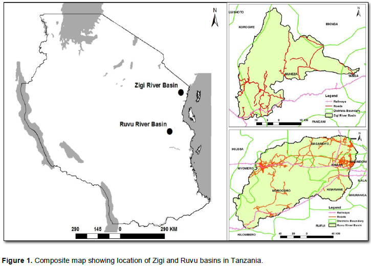
The study sites include the Zigi River Basin in the East Usambara Mountains and the Ruvu River Basin in the Uluguru Mountains (Figure 1). The two basins are important landscapes with mosaics of multiple land uses, and they form part of the larger Eastern Afromontane biodiversity hotspot of Tanzania. Zigi River Basin is composed of three main sub-catchments, which are (i) Zigi, (ii) Kihuhwi and (iii) Muzi; while Ruvu River Basin is composed of five main sub-catchments,( i) Mgeta, including Msoro, (ii) Ngerengere, (iii) Upper Ruvu, (iv) Middle Ruvu, and (v) Lower Ruvu.
Description of Zigi and Ruvu River Basins
General characteristics of the study sites (Table 1) include mountainous zone and lowland flat area and the flood plains.
Data collection
Socio-economic data related to livestock management were collected through Key Informant Interview (25 individuals were interviewed), Focused Groups Discussion (246 individual participated) and Individual Questionnaire Survey (128 individuals were interviewed). Key informants interviewed included people with broad knowledge in the local settings related to the livestock management including leaders in the villages, wards and experts from District Authorities. Feed Assessment Tool (FEAST) developed by ILRI (https://www.ilri.org/feast) was used in conducting Focus Group Discussions (FGD), involving about 12 to 16 people selected objectively from different categories of livestock keepers. As per FEAST protocol, the Individual Questionnaire Survey was administered among participants of the FGD to gather further insights about livestock management at household level as recommended by Mangesho et al. (2013).
Participatory field observations were done in selected areas villages (Table 2) through Transect Walk method, 5 and 3 transect walks were done at Ruvu and Zigi Basin respectively. Establishment of the transects were done in collaboration with local leaders taking into account areas designated for livestock grazing as per existing village land use plans. In absence of land use plans, areas designated and used for grazing were also identified, visited and assessed and recorded. Participatory GIS was used to allow local people familiar with long term historical narrative of the area to record spatial details of existing land cover and land use (URT, 2015). It was also used to pinpoint areas affected by degradation, the extent of land that is currently under settlement and later correlate this with population sizes and densities; and the extent of land in each basin used for grazing migration routes. It was further used in mapping seasonal movements of livestock and identify (by type, location and scale), a suite of prospective sustainable livestock management technologies.
The Feed Assessment Tool (FEAST) is a systematic method to assess local feed resource availability and use. It helps in the design of intervention strategies aiming to optimize feed utilization and animal production. The tool comprises two main elements: (a) a focused PRA exercise which provides an overview of the farming system with particular emphasis on livestock feed aspects. and (b) a simple and brief quantitative questionnaire, designed to be completed by experts under the guidance of the Feast facilitator.
Data analysis
Standard methods for data analyses were applied for both socio-economic and biophysical information. Description statistics were computed for mean, standard deviation, standard error, maximum and minimum. Combination of multiple tools/software was used including SPSS and excel spreadsheet for socio-economic and simple arithmetic data, while FEAST tool version 2.2 and R-software (https://www.r-project.org/) were used. Remote sensed data were analyzed using IMPACT software developed by the EU Joint Research Centre. Narratives from local people were useful in providing understanding of the socio-economic forces behind land use and land cover modifications. The land degradation map was generated by using weighted overlay tool in ArcGIS. The tool combines the following four steps:
(i) Identification of the input rasters. The major factors which were used for the weighted multi-criteria evaluation includes; distance from rivers, distance from roads, distance from cultivated lands.
(ii) Reclassification of values in the input raster into a common evaluation scale of risk. All the raster were reclassified into a common risk scale of 1 to 3, with 3 being the most vulnerable and 1 being the lowest vulnerable to land degradation.
(iii) Assigning of weights to factors. Weights were assigned to each factor in order of its importance (distance from river = 0.4, distance from major road = 0.3, distance from cultivated lands = 0.3) and a total score was obtained for each alternative by multiplying the importance weight assigned to each attribute by the scaled value.
(v) Overlay analysis. Add the resulting cell values together to produce the output raster indicating high, medium and low vulnerable areas to land degradation.
The landscape degradation was limited to distance from rivers, from roads and cultivated lands only because of the study objective was to undertake a comprehensive biophysical resources assessment of the Ruvu and Zigi catchments for development of decision support tools to enable effective management, with emphasis on:
(i) Updating land-cover data for Ruvu and Zigi catchments
(ii) Identifying and map badly degraded areas both within and outside of protected areas, especially those that might require specific rehabilitation measures
(iii) Assessing the extent of land that is currently under settlement and correlate this with population sizes and densities
Under such circumstance it was important to focus on a key predictors that enabled to isolate key drivers of land degradation.
R Core Team (2013). R: A language and environment for statistical computing. R Foundation for Statistical Computing, Vienna, Austria. (URL http://www.R-project.org/.) Accessed 24th April 2018.
Livestock concentration in Ruvu and Zigi catchments
Livestock is unevenly distributed in the two catchments (Table 3) with higher number in the Ruvu compared to Zigi. The number of cows and goats in Ruvu is almost double that of Zigi catchment. The livestock density in Ruvu catchment has been indicated to be around 2.25 to 8 ha per livestock unit (LU) per year (Millao, pers. comm. 2018). The overall current carrying capacity ranges from 2 to 8 LU per ha per year. This state of affair has rendered the catchment into large livestock population.
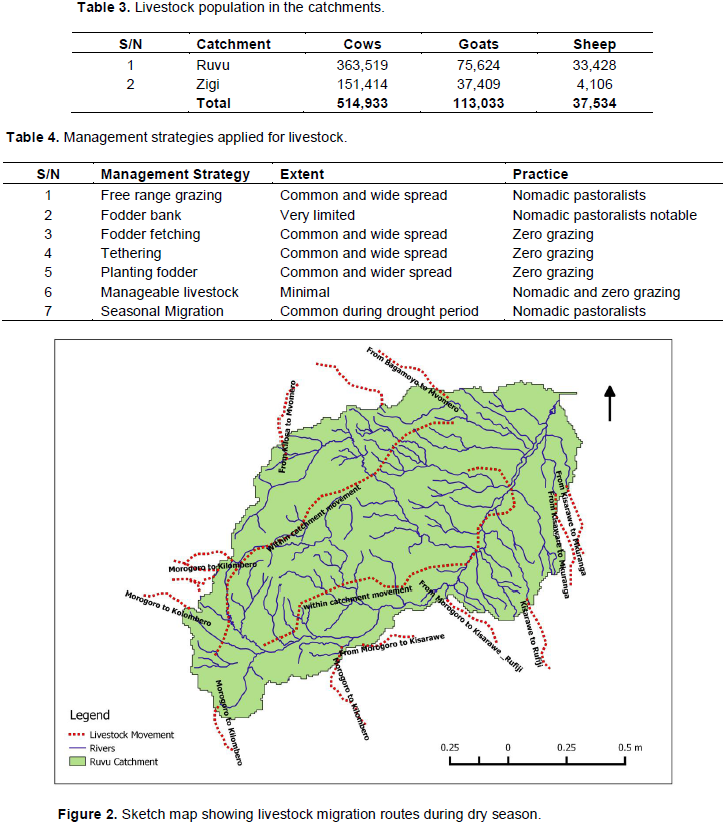
The management strategies of livestock in the catchment is diverse because of the aggregate nature of the study area and the livestock keeping practices (Table 4). There are basically two predominant practices which are nomadic and zero grazing. The management strategies employed are either stand alone or a combination of more than one strategy. Results from stakeholders’ consultations indicated that livestock migration in Ruvu and Zigi River basins occurs in three patterns; i) inward flow, ii) outward flow and iii) internal movements within the basins (Figure 2). The migration occurs mainly from the onset of dry season, and the distance ranges from few to tens of kilometres while time ranges from weeks to months.
Land degradation in the Ruvu and Zigi Basins
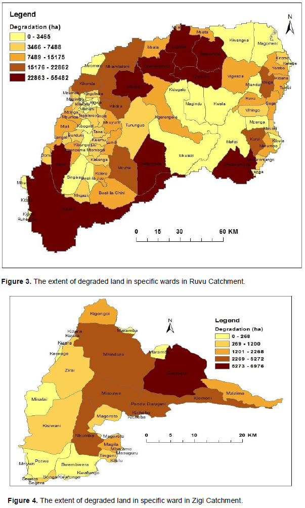
Results from combination of tools including participatory mapping, remote sensing and geographic information system (GIS), and stakeholders’ consultations have indicated that some areas in the Ruvu and Zigi basins have been degraded and remain vulnerable to further degradation (Figures 3 and 4) due to rapid population growth, natural resources exploitation and abject poverty (USAID, 2008). It should be noted that the extend of land degraded in specific wards of the study areas were classified using the rank to indicate from less degraded to more degraded in hectare as was observed during baseline survey of the Sustainable Land Management (SLM) project, it does not rank degradation as severe or less severe. The area range is just indicative of the extent for ease aggregation of the extent.
Number of livestock vs. carrying capacity
Livestock keeping in Tanzania is dominated by agro-pastoral communities that engage in both crop farming and animal husbandry (URT, 2015). Due to this dual livelihood practices, most of the communities are attracted to areas that are fertile to enable crop farming but also access to grazing land (Engida et al., 2015).
The Ruvu and Zigi basins provide best landscapes to the realization of these agro-pastoral communities IUCN, 2010a). In terms of livestock, the two basins harbour a considerable number of livestock (Table 4). (However, Ruvu basin accommodate more livestock compared to Zigi basin due to its large size and
connectivity to other livestock rich areas (IUCN, 2010a). At current levels, the number of livestock in Ruvu basin
exceeds its carrying capacity (it should be noted that the average carrying capacity for both catchments ranges from 2 - 8 LU per ha per year), mainly with large amount of livestock located in the lowland areas. In contrast, the livestock keeping in Zigi basin is much more lucrative compared to the Ruvu basin, partly contributed by use of improved breeds and presence of formalized milk trade (AECF, 2011).
The terrain of these two basins influence the management practices of livestock keeping, whereby in the mountainous areas it is mostly zero grazing while in the lowland is mostly free grazing (Mangesho et al., 2013, Covarrubias et al., 2012). Sharp contrast exists in Ruvu and Zigi basins in terms of livestock keeping as different management strategies are employed. While Ruvu is dominated by free range, extensive and seasonal migration model, the situation is different in Zigi basin which exhibits zero grazing and limited stock size. In the Ruvu basin, large rangeland plains are found throughout the southern part of the basin, extending in Ngerengere plains, around Wami-Mbiki Wildlife Management Area and Chalinze woodland area (IUCN, 2010b). This vast area contains forests and woodlands that are less inhabited by humans hence provide extensive ground for livestock grazing.
Livestock grazing under free range in Ruvu basin have contributed to the accelerating reduction of the tree cover of the basin through tree cuts in favour of grasses (IUCN, 2010a). The strategy of undertaking tree cuts to allow creation of open spaces for grasses to flourish have been responsible for land degradation in other parts of Tanzania including Shinyanga (Duguma et al., 2013). The southern part of the Ruvu basin has also served as a source of charcoal to Morogoro, Pwani and Dar es Salaam regions (Malimbwi and Zahabu, 2007). The parallel objectives of charcoal extraction as a means to open areas for grazing have not been systematic but rather undertaken by two different groups with its own goals. While the charcoal extraction individuals do it as a means of livelihood during dry season, the latter keeps the livestock in the areas to suppress regenerations and coppicing of the trees and shrubs to make it permanently grassland. Lessons from sustainable charcoal production in Kilosa district have shown that in areas where charcoal has been extracted, prevention of livestock from grazing in that area has led to about 88% regeneration of the tree and shrubs vegetation (Sangeda and Maleko, 2018). Therefore, with unchecked charcoal extraction in the Ruvu basin the risks of land degradation stand very high. Along the Morogoro-Dar es Salaam highway, one could see a sharp difference of the vegetation cover on opposite sites near Kitulangalo and Ubena-Zomozi, between protected and unprotected areas that just in previous 30 year’s time used to be similar.
Seasonal migration of livestock in the basins
Movement of livestock to and from the two catchment is very prominent in pursuit of seasonal grazing lands and in search for water resources (IUCN, 2010b). The influx of livestock in Ruvu catchment is mainly from neighbouring districts, while for Zigi catchment, the influx is mainly from very distant districts. The Ruvu basin is in close proximity to areas with large stocks of livestock including Kilosa, Mvomero, Kilombero, Rufiji and Mkuranga districts, which are renown for higher concentrations of livestock. Regular conflicts have been reported between pastoralists and crop farmers in the neighbouring districts of Kilosa and Mvomero due to overpopulation of the livestock and dwindling grazing areas (IUCN, 2010a; URT, 2015). Therefore, Ruvu basin is oftentimes used as a buffering area to accommodate additional livestock from other areas during dry season. However, the movement of livestock is not regulated, causing overcrowding in the Ruvu basin, and hence contribute to land degradation.
Similarly, Ruvu basin forms the traditional end of the long migration route of livestock which seasonally traverse from Kiteto to Bagamoyo districts (URT, 2015).
Currently, the National Land Use Planning Commission (NLUPC) of Tanzania is developing a pilot scheme to allow gazettement of livestock migration route in the eastern zone traversing the eastern part of the Ruvu basin. The effort will address land use conflicts due to improper tenure regime between pastoralists and agriculture. The government of Tanzania has also launched a countrywide program to label and mark livestock per each district to restrict unwarranted movements.
Livestock vs. land degradation
Landscape degradation in the two basins is eminent mainly due to excessive human induced disturbances (USAID, 2014, Yanda and Munishi, 2007). Scale of degradation differs among various categories of land uses in the landscape, for instance, the highlands vs. lowland, protected vs. unprotected areas, farming practices and charcoal extraction. Within the protected areas, degradation is mostly due to encroachment of human activities which are considered to be illegal and should be contained by effective law enforcement. Incidences of livestock grazing within protected areas such as forest reserves and Wami-Mbiki WMA have been very common in the Ruvu basin. Detrimental effect of grazing in the forest reserves has been related to trampling of the seed banks and regenerants hence compromising natural recruitment of the trees and shrubs similar to the observation by Armour et al. (1994) in Western Riparian Ecosystem. However, the degradation within protected areas is relatively small in terms of magnitude but significant. Despite that some of the degradation are not easily recorded or conceptualized in terms of vegetation cover, but they interfere with the functioning of the ecosystems. It has also been noted that high risks for land degradation face areas that are closer to the main access roads, close proximity to rivers and where there is intensive cereal crops cultivation, this observation matches with what was observed by Yanda and Munishi (2007).
In the zone outside protected areas, management of land uses falls under the jurisdiction of village government, town and district councils, municipals and/or city’s authorities. The challenge of land degradation outside protected areas is a result of improper planning of the land uses and its enforcement (URT, 2009). Key drivers include; Overgrazing: Livestock keeping in the lowland areas of the two river catchments are exercised by free range. However, there signs of overgrazing due to excessive opening up of areas that are neither cultivation land nor used in other economic activities (URT, 2009). This trend further exacerbates land degradation due to soil compaction and erosion, damage to water sources and impairs biodiversity. Two types of grazing are experienced in the basins; one is the permanent inhabitation of the livestock with amounts to hundreds of thousands, and secondly is the seasonal influx of livestock looking for pasture and water from other distance areas. It is recognized that during certain seasons, livestock from outside the basin as far as Simanjiro and Kiteto cross all the way to part of Tanga and then to the Coast regions, ending up spreading to the lower parts of the two catchments (Msuya, 2009). The seasonal influx of livestock is very detrimental as the numbers are very large herds of cattle, beyond the carrying capacity of the land.
The Ruvu and Zigi basins are important in hydrological and biodiversity perspective in supporting human livelihood. The two basins are renowned for their state of ecosystem services, regarded as part of the water towers in the eastern bloc of the country. In pursuit for pasture and water, concentration of livestock in the basins has exceeded the carrying capacity, and thus threatening their ecosystem integrity. Uncontrolled influx of livestock from nearby and distant areas, has contributed to the deterioration of the state of ecosystem services. Range lands are not delineated, grazing is done all over the catchments, these situations have been causing frictions in the community between farmers and pastoralists. The outcome of the uncontrolled livestock management is increasing degradation of the land resources in various areas within the two basins. The study recommends agroforestry practices in the mountainous areas, and development and enforcement of land use plans in the lowland areas. Range land for grazing should be delineated, with subsequence installation of necessary infrastructures and markets for livestock products. The rangeland carrying capacity should be maintained to avoid excessive number of livestock. Use of both modern and indigenous knowledge on maintenance of pasture area should be stressed.
The authors have not declared any conflict of interests.
REFERENCES
|
Armour C, Duff D, Elmore W (1994). The Effects of Livestock Grazing on Western Riparian and Stream Ecosystem. Fisheries 19(9):912.
Crossref
|
|
|
|
Cetin M, Onac AK, Sevik H, Canturk U, Akpinar H (2018a). Chronicles and geoheritage of the ancient Roman city of Pompeiopolis: a landscape plan. Arabian Journal of Geosciences 11:798.
Crossref
|
|
|
|
|
Cetin M, Sevik H, Canturk U, Cakir C (2018b) Evaluation of the recreational potential of Kutahya Urban Forest. Fresenius Environmental Bulletin 27(5):2629-2634.
|
|
|
|
|
Cetin M, Sevik H (2016a). Evaluating the recreation potential of Ilgaz Mountain National Park in Turkey. Environmental Monitoring and Assessment 188(1):52.
Crossref
|
|
|
|
|
Cetin M, Sevik H (2016b). Assessing Potential Areas of Ecotourism through a Case Study in Ilgaz Mountain National Park, In Tech, Chapter 5, Eds: Leszek Butowski 190:81-110. View
Crossref
|
|
|
|
|
Cetin M (2015a). Determining the bioclimatic comfort in Kastamonu City. Environmental Monitoring and Assessment 187(10):640
Crossref
|
|
|
|
|
Cetin M (2015b). Evaluation of the sustainable tourism potential of a protected area for landscape planning: a case study of the ancient city of Pompeipolis in Kastamonu. International Journal of Sustainable Development and World Ecology 22(6):490-495.
Crossref
|
|
|
|
|
Cetin M (2015c). Using GIS analysis to assess urban green space in terms of accessibility: case study in Kutahya. International Journal of Sustainable Development and World Ecology 22(5):420-424.
Crossref
|
|
|
|
|
Cetin M (2015d). Consideration of permeable pavement in Landscape Architecture. Journal of Environmental Protection and Ecology 16(1):385-392.
|
|
|
|
|
Covarrubias K, Nsiima L, Zezza A (2012). Livestock and livelihoods in rural Tanzania. A descriptive analysis of the 2009 National Panel Survey.
|
|
|
|
|
Duguma LA, Minang PA, Kimaro AA, Otsyina R, Mpanda M
|
|
|
|
|
(2013). Climate Smart Landscapes: Integrating Mitigation, Adaptation and Development in Shinyanga Region, Tanzania: 4.
|
|
|
|
|
Engida E, Guthiga P, Karugia J (2015). The Role of Livestock in the Tanzanian Economy: Policy Analysis Using a Dynamic Computable General Equilibrium Model for Tanzania. 29th International Conference of Agricultural Economists. Agriculture in an Interconnected World. Universta Degli Di Milano. 8 - 14 August 2015.
|
|
|
|
|
IUCN Eastern and Southern Africa Programme (2010a). The Ruvu Basin: A Situation Analysis., xvi + 96 pp
View
|
|
|
|
|
IUCN Eastern and Southern Africa Programme (2010b). The Wami Basin: A Situation Analysis., xviii + 92 pp.
|
|
|
|
|
Kaya E, Agca M, Adiguzel F, Cetin M (2018). Spatial data analysis with R programming for environment. Human and ecological risk assessment: An International Journal, pp. 1-10.
Crossref
|
|
|
|
|
Malimbwi RE, Zahabu EM (2007). Woodlands and the charcoal trade: the case of Dar es Salaam City. Research and development for sustainable management of semiarid miombo woodlands in East Africa. Working Papers of the Finnish Forest Research Institute 98:93-114.
|
|
|
|
|
Mangesho WE, Loina R, Bwire J, Maass BL, Lukuyu B, Wassena FJ (2013). Report of a Feed Assessment 3 - Lushoto District, Tanga Region, the United Republic of Tanzania. Report. International Center for Tropical Agriculture (CIAT).
View
|
|
|
|
|
Msuya AJ (2009). Analysis of Pastoralists and Farmers in Northern Part of Tanzania from Land Administration Perspective. A Thesis Submitted to ITC as Partial Fulfillment for the Requirement of the Degree of Masters of Science in Geonformatic Science and Earth Observation.
|
|
|
|
|
Sangeda AZ, Maleko DD (2018). Regeneration Effectiveness Post Tree Harvesting in Natural Miombo Woodlands, Tanzania. Journal of Plant Science and Agricultural Research 2(1):10.
|
|
|
|
|
The Africa Enterprise Challenge Fund (AECF) (2011). Tanga Fresh AECF Case Study.
|
|
|
|
|
United Republic of Tanzania (URT) (2007). National Adaptation Programme of Action (NAPA). Vice President's Office, Division of Environment. View
|
|
|
|
|
United Republic of Tanzania (URT) (2009). Fourth National Report on Implementation of Convention on Biological Diversity (CDB). Published by the Vice President's Office, Division of Environment, United Republic of Tanzania (URT), Dar es Salaam 2009. ISBN: 9987-8990-
View
|
|
|
|
|
United Republic of Tanzania URT (2010). Livestock Sector Development Strategy. Government Printer -Dar es Salaam.
|
|
|
|
|
United Republic of Tanzania (URT) (2015) Tanzania livestock modernization initiative. Dar es Salaam, Tanzania: Ministry of Livestock and Fisheries Development. View
|
|
|
|
|
USAID (2008). A Profile of the Wami River Sub-Basin. Prepared by the Coastal Resources Center at the University of Rhode Island for Tanzania. Coastal Management Partnership for Sustainable Coastal Communities and Ecosystems in Tanzania.
View
|
|
|
|
|
USAID (2014).Wami River Basin, Tanzania, Environmental Flow Assessment Phase II, GLOWIS-FIS. Tanzania Integrated Water, Sanitation and Hygiene (iWASH) program.
|
|
|
|
|
WWAP (United Nations World Water Assessment Programme) (2006). Water: a shared responsibility; the United Nations world water development report 2. United Nations Educational, Scientific and Cultural Organization (UNESCO). UNESCO Digital Library.
View
|
|
|
|
|
Yanda PZ, Munishi PKT (2007). Hydrologic and Land Use/Cover Change Analysis for the Ruvu River (Uluguru) and Sigi River (East Usambara) Watersheds. Report to WWF/CARE for the Equitable Payment for Watershed Services Project. 87p.
View
|
|
|
|
|
Yigit N, Sevik H, Cetin M, Kaya N (2016b). Determination of the Effect of Drought Stress on the Seed Germination in Some Plant Species. Chapter 3, Intech Open, Water Stress in Plants, Eds: Ismail Md. Mofizur Rahman, Zinnat Ara Begum, Hiroshi Hasegawa, pp. 43-62.
Crossref
|
|
|
|
|
Yucedag C, Kaya LG, Cetin M (2018). Identifying and assessing environmental awareness of hotel and restaurant employees' attitudes in the Amasra District of Bartin. Environmental Monitoring and Assessment 190(2):60.
Crossref
|
|