Full Length Research Paper

ABSTRACT
In southeast Niger, the degradation of the environment led to the reactivation of moving dunes that threatens infrastructure, fields, and river with silting. To stabilize the dune cordon of Namaro, which is heavily cultivated and grazed, anti-erosion devices: living hedges and grassland has been developed. The objectives of this work are then to characterize the impact of grassland and hedges on floristic diversity and to highlight the herbaceous species that are most induced a better ecological restoration in this dune environment. The soil cover, floristic diversity, and phytomass yield were determined on the control surfaces (rangelands), as well as on a grassland and living hedges areas. It appeared that the highest biomass yield was recorded in the hedges areas (61.74 kg.ha-1 of dry matter). The density of herbaceous in the hedgerow and grassland is increased of at least 2 times of the relative to the rangeland. The inventory of herbaceous families showed that Corchorus Tridens Incidentally Schwenckia americana marked a decrease in pressure and an improvement in the conditions for the development of vegetation on the dune. Evolvulus alsinoides and Zornia glochidiata are the most resilient species and marked the adaptation of the vegetation on the heavily grazed dune.
Key words: Namaro, dune cordon, vegetation, land use.
INTRODUCTION
Vegetation plays a vital role for terrestrial environments. It influences carbon and nutrient cycling (Freschet et al., 2018; Leroy, 2019 ; Hain, 2020), crop productivity and soil erosion (Ouatara et al., 2018; Abdourhamane et al., 2019; Moreau et al., 2019). In the case of wind erosion in particular, the height and rate of cover of the soil surface by vegetation plays a crucial role. This is because vegetation protects the soil for a distance equivalent to ten times its height (Webb et al., 2020). A soil cover of 2 to 10% by plant residues reduces erosion of Sahelian sandy soils by more than 3 times compared to bare soil (Abdourhamane, 2011; Okothomas, 2019). It has also been shown that a vegetation cover of 40% almost annihilates wind erosion of soils (Fryrear, 1985).
However, vegetation is under pressure and degradation in the Sahel. Indeed, the Sahel is a very sensitive environment to climatic variations (Ozer et al., 2010; Brüning and Piquet, 2018). Rainfall variability has been marked, for example, by recurrent droughts that were particularly severe in the 1970s and 1980s (Descroix et al., 2015; Brüning and Piquet, 2018). One year out of two is rainfall deficient causing a degradation of the biophysical environment (Idrissa et al., 2020). The effect of this climatic pejoration has been accentuated by human pressure (Gemenne et al., 2017; Baldé et al., 2020). The Sahel is the region of the world that has experienced the largest population increase in recent years (Garenne, 2016a, b; Dramani and Mbacké, 2017; Guengant and Delaunay, 2019). The rate of degradation, which is highly variable, is therefore following a trend that is accelerating under the combined effect of periodic droughts and the ever-increasing anthropogenic pressure on resources that have become scarce and fragile (Gbetkom, 2020; Tacon, 2021). The degradation of vegetation is particularly important on fragile surfaces such as dunes. These are heavily grazed and/or cultivated (Idrissa et al., 2020). In Southeast Niger, 26% of the cultivated surfaces have been lost from 1985 to 2005 and have been taken over by mobile dunes due to sand remobilization (Tidjani, 2008). The reactivation of sand dunes surfaces have been observed on ancient cultivated and/or overgrazed area in the east of Niger (Moussa et al., 2014). These pressures have notably led to the reactivation of moving dunes in eastern Niger (Malam et al., 2018; Boureima et al., 2019). The current evolution of these landscapes is therefore characterized by a desertification marked by an advance of the dune fronts of an average of 5.60 ± 2.02 m / year (Tidjani et al., 2017).
However, mobiles dunes cause many environmental and socio-economic problems. They bury crops, pastures, water points and infrastructures (Tidjani et al., 2017). Thus, to protect these assets, mechanical dune fixation has been undertaken in several localities of SE Niger. These fixations consisted of the construction of mechanic hedges. The hedges are maintained for the first three years to allow herbaceous vegetation to grow naturally at the hedge lines.
The dune cordon of Namaro is a particular ecosystem because it is located along the river in a relatively humid environment (525 mm of rain per year). The degradation of its surface by heavy cultivation and grazing led to the reactivation of moving dune which threatens infrastructure, field and river with silting. So to restoration and protect the dune area, anti-erosion devices have been developed since 2006 by the program to fight against silting of the Niger River (PLCE/BN, 2006). It has therefore carried out developments with the aim of developing vegetation on the dune cordon of Namaro. These managements consisted in the construction of grassy surfaces and hedges. However, the ecological role and impact of management has not been evaluated after more than 10 years of implementation. The objective of this work is to characterize the vegetation the Namaro dune in relation to land use. Specifically, it is to: i) characterize the impact of the anti-erosion devices (grassy surfaces and hedges) on the vegetation in terms of coverage, yield and floristic diversity and ii) for the rangelands surfaces most sensitive to wind erosion, to characterize the dynamics of the soil cover by vegetation, which is a fundamental parameter of the dissipation of the energy of the erosive winds.
MATERIALS AND METHODS
Study site
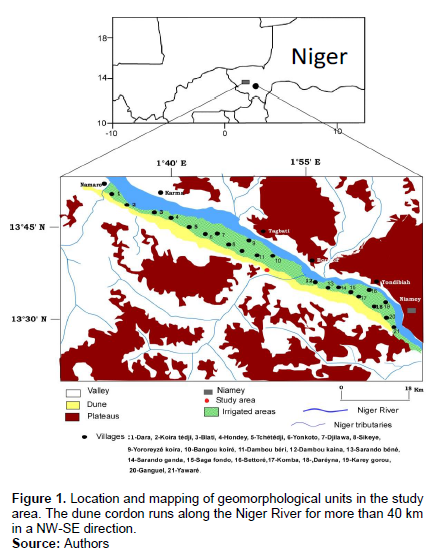
The Namaro dune cordon on which this study is conducted is a sandy accumulation 25 m thick, 2 km wide and 44 km long (PLCE/BN, 2006). The intensification of cultivation and grazing on its surface has increased the winds erosivity and the reactivation of moving dune in some places. Woody vegetation, essentially shrubby, is very sparse and dominated by Faidherbia albida and Annona senegalensis (PLCE/BN, 2006).
The climate is semi-arid. The average annual rainfall recorded between 1950 and 2007 is 525 mm (Lebel and Ali, 2009). The rainfall recorded in rainy season between June and September is often deficient (one year out of two) and is marked by recurrent droughts. The essentially sandy and nutrient-poor soil supports the main activities of the population. This population,with a density of 43 hbts/km², is 96% rural and its main activities are agriculture and livestock (PLCE/BN, 2006). The study site is located on the dune cordon of Namaro at 30 km northwest of Niamey and 2 km from the village of Bangou Koiré (13°33'34''N-1°54'28'') (Figure 1). The measurements were made on four types of land use:
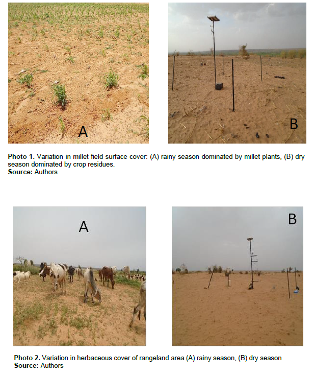
(i) Rangeland of nearly 40 ha: the grazing is free on its surface every season (Photo 1). The presence of the animals is approximately 660 small ruminants and 425 big ruminants per day (Photo 2). The grazing area is dominated by grasses that grow naturally during the rainy season (June to September).
(ii) The anti-erosion devises on the dune surface includes grassy and living hedges areas. These devises cover 26 ha and were built and protected by the Program to Combat Silting of the Niger River in 2006.
The grassed areas aim to protect the surface of the dunes from erosion but also to constitute a stock of food for the livestock (Photo 3). Twelve endogenous herbaceous species were planted on the grassy areas in 2006. In the years following 2006, theses grasses have been seeding in 2007 and 2008. This devices is only partially protected. In fact, the grasses that do grow are not grazed and are only harvested at the end of the dry season (May) and sold in bunches to agropastoralists by the village management committee. The living hedges are made up of Euphorbia lamarckii planted in the form of a square mesh of about 20 m on each side (Photo 4). In the square natural grasses grow up (Photo 4). At this level, there is total defensiveness: no grazing or grass collection is authorized by the management committee.

Vegetation sampling
Vegetation cover
This was determined on the rangelands. Two types of cover were determined according to seasons and the appearance of the vegetation. These were the rate of cover by green vegetation during the rainy period (June-October) and a rate of cover by dry residues during the dry period (December-June).
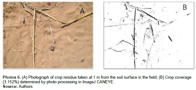
The vegetation cover rate was determined using photographs taken at 1 m from the soil ground. To take of the variability of the plot, twenty points were photographed every week. The photographs were processed on CANEYE © (Diawara et al., 2020) (Photo 5) and ImageJ © (Abdourahamane Touré et al., 2011) (Photo 6) to determine the green vegetation cover rate and the residue cover rate respectively.
Quantification of biomass yield
Biomass yield was quantified on rangeland, grassy area and in the live hedgerow area. Quantification was conducted at the end of the rainy season (October), when the grasses have reached maturity.
A 1 m×1 m quadrant (Photo 6) was used to quantify biomass yield. Sampling was conducted along two orthogonal transects on the open rangeland and grassy area. Each transect had ten sampling points spaced 10 m apart. The same quadrant was used in the hedgerow area where two types of transects were delimited: the first is located two meters and the second 10 m from the hedgerow line. In the hedgerow area, eight transects were delineated. Each transect had 5 sampling points spaced 5m apart (Photo 4).

Grasses were collared on the rangeland, grassy area and hedgerow areas. The collected grasses were then dried at room temperature for 21 days and the dry residue yields were calculated (Equation 1). It should be noted, however, that prior to collection of the grasses, the inner surface of the quadrant was photographed and then the vegetation cover was determined under CAN EYE.
RS= M/S (1)
Where RS: dry residue yield; M: average of dry herbaceous masses collected in the transect; S: area of the (1 m × 1 m).
Inventory of herbaceous species on uses
It was carried out concomitantly to the measurements of the biomass on the course, and the area of the living hedges. It was thus determined in 20 point quadrants of 1 m² on the rangeland as well as on the grassy area and on 40 point quadrants in the area of the living hedges. Herbaceous species were identified and their numbers and relative frequencies (Pe) were calculated in each soil use (Equation 2).
Pe=Σni/N (2)
Where Σni= number of the individuals of specie i on the land use; N= number of the individuals of all species on the land use.
For each species, a mean density (number of the individuals of specie i per m² on the land use) has been calculated (Equation 3). A statistical test (ANOVA, with a threshold of 5%) was performed to compare the mean densities calculated for each land use.
de = Σni/S (3)
Where de = a mean density of specie i on the land use; Σni= number of the individuals of specie i on the land use; S = surface of the measurement which is 20 m² on the rangeland and grassy area and 40 m² in the hedges.
RESULTS AND DISCUSSION
Dynamics of soil cover by vegetation on the rangeland
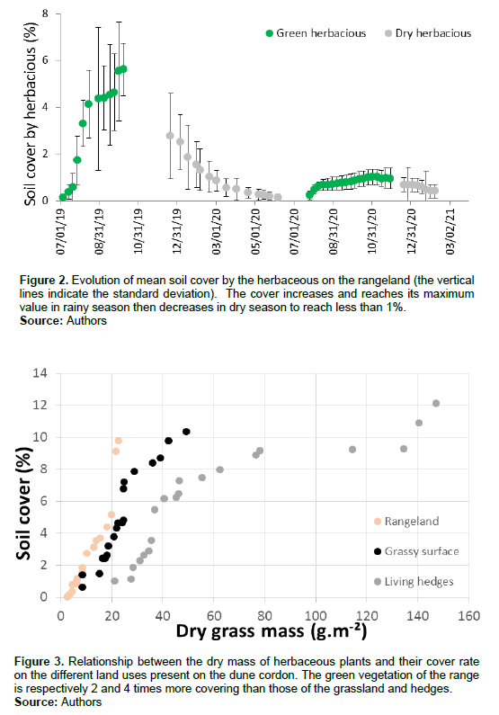
Vegetation cover showed a unimodal annual evolution marked by an expansion of grasses during the rainy season (July-October) (Figure 2). The greatest expansion of herbaceous occurs in July after the monsoon jump and the regularity of rainfall (Figure 2). In the Sahel, it has been shown that the development of herbaceous cover is particularly sensitive to rainfall distribution (Hiernaux et al., 2010). On the rangeland, grasses reached their maximum cover of 7.76% and 1.86% respectively in the middle and end of the rainy season in 2019 and 2020 (Figure 2). Green herbaceous cover showed inter-annual variability. Indeed, it is recognized that in the Sahel, herbaceous cover can vary on the same site from one year to another depending on climatic conditions (Hiernaux and Le Houérou, 2013): during the 2019 rainy season, cover was 4 times greater than in 2020 (Figure 2). The lower herbaceous cover in the 2020 rainy season than in 2019 is opposite to that of recorded rainfall (Figure 2). This would most likely be related to greater pastoral pressure in 2020. Rangeland surface cover was less dense than on the Kilakina (East Niger) and Gourma Malien rangelands where it exceeded 30% (Mougin et al., 2014; Abdourhamane et al., 2019; Diawara et al., 2020). During the dry season, the cover for herbaceous residues decreased steadily. It decreased from 5% in November to less than 1% in June in 2019 and from 1.5% in December to less than 1% in June 2020 (Figure 2). The decline in residue cover is particularly rapid during the first few months after the rainy season, as it has been observed on both the Niger and Mali rangelands (Hiernaux and Le Houérou, 2013; Abdourhamane et al., 2019). The decrease in residue cover is therefore classic on sahelian rangelands. It is mainly explained by pastoral pressure and secondarily by the burial of residues by wind deflation.
The interannual variability of residue cover is closely linked to the rainy season. Indeed, the rate of residue cover in the dry season is related to the rate of cover developed during the previous rainy season. The higher growth of the rainy season in 2019 induced a higher residue cover in the following dry season (Figure 2).
Variation in biomass yield by land use
Biomass yield varied greatly by soil use. The biomass yield of the Hedgerow was 6.3 and 2.6 times higher than those of the rangeland and the grassland area respectively. Plant production in the Hedgerow can be therefore a major source of animal feed and fodder stock in the dry season. On the rangeland, the biomass measured at the end of the rainy season was 9.79 kg.ha-1: the yield on this land use would probably have been higher taking into account the removal due to grazing. Figure 3 has allowed us to discriminate between the different land uses. It shows a linear increase in the cover of the rangeland and the grassed area as a function of the mass of the herbaceous plants. In the living hedges, a linear increase in cover is also apparent for low herbaceous masses (less than 80 g.m-²). For larger masses, the efficiency of ground cover by grasses decreased in the live hedges (Figure 3). Comparing the various land use, it appears that the rangeland plants are 2 and at least 4 times more covering than those of the grassed areas and the hedgerows (Figure 3).
Variation of herbaceous families and species according to land use
Twenty-four species divided into 17 families were inventoried on the dune cordon under an average rainfall of (525 mm). This diversity is lower than that observed on the Toukounous rangelands (West Niger) and close to Sayam rangelands (East Niger), where 75 and 27 species were counted respectively (Idrissa et al., 2020). Annual rainfall in Toukounous and Sayam is at most 350 mm over the last 60 years. Rainfall in these areas is less than at Bangou Koiré where floristic diversity is relatively low. The difference in floristic diversity could therefore be related to the nature of the soils. Indeed, the rangelands in Bangou Koiré are located at the top of the dune while in Toukounous, for example, they are distributed between lowlands and plains (Saidou and Ambouta, 2013).
Herbaceous plants on all land uses (rangelands, grassy area, hedgerows) were marked by differences in the number of families and species (Table 1). In fact, in the area of living hedges, 15 families were listed that is, 2 and 4 more than in the grassy area and rangelands respectively (Table 1).
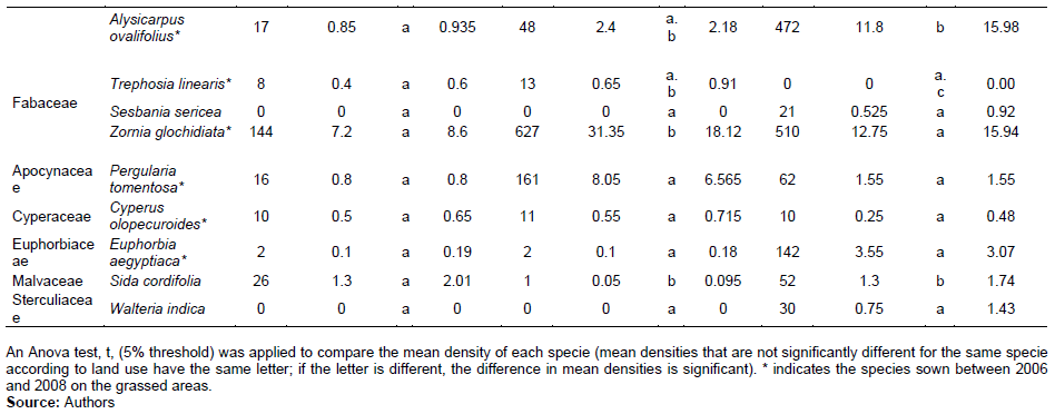
On the rangeland, seventeen species inventoried with a total 493 individuals counted. The most diversified families: Fabaceae and Poaceae with 3 species; Convolvulaceae and Papilionaceae with 2 species (Table 1). All these species are natural. Four of the species (Evolvulus alsinoides, Zornia glochidiata, Sida cordifolia and Cenchrus biflorus) have a density greater more than one individual per m². The cumulated relative frequency of these species represents more than 78% on the rangeland.
On the grassed surface, nineteen species were recorded with a total of 1086 individuals counted. The most diversified families on the grassed areas are, Fabaceae, Papilionaceae, and Convolvulaceae, with 2 species and Poaceae with 3 species (Table 1). Twelve endogenous species were sown between 2006 and 2008, but they did not develop harmoniously. Indeed, only four
species have an average density higher than one individual per square meter. These are Pergularia tomentosa, Z. glochidiata, Alysicarpus ovalifolius and Eragrotis tremula (Table 1). These species represent more than 90% of the relative frequency of species inventoried on the grassed areas.
Indeed, nineteen species divided with a total 2457 individuals were counted on the living hedges. The most diversified families are: Malvaceae, Poaceae, Papilionaceae and Rubiaceae which count two species each (Table 1). It should be remembered that all the species grew naturally in the area of the hedgerows. Nine of these species have an average density greater than one individual per m² (Table 1). These are particularly Z. glochidiata, A. ovalifolius, E. tremula and Mitraearpus villosus which has a density of more than 10 individuals per square meter. These four species represent more than 75% of the relative frequency of species inventoried on the living hedges (Table 1). The role of the devices in ecological restoration is thus apparent, with an increase in the number of families and species in the hedgerow and grassy areas relative to the grazed range. Thus, the number of grasses was 61, 54 and 25 individuals per m² respectively in the hedgerow area, the grassy areas and the rangelands. The density of grasses that are close on the landscapes (grassy areas and hedges) are more than twice that of the rangelands. The role of managed areas in the diversity and the floristic richness quantitatively and qualitatively was also observed in the pastoral spaces of the semiarid area (Benaradj and Boucherit, 2014; Idrissa et al., 2020).
The herbaceous families inventoried on the rangeland with high grazing pressure, were observed on all the other two land uses (grassy area and living hedges) (Table 1). These families, mainly dominated by Poaceae, Malvaceae, Papillonaceae and Convolvulaceae, appear to be the resilient forbs on the dune. The most resilient species are E. alsinoides and Z. glochidiata which have a relative frequency of 33.47 and 29.25% respectively in the rangeland. Z. glochidiata, however, remains a major species at least 20% of relative frequency on each of the land uses (Table 1). This species belongs to the Malvaceae family which is recognized for its resistance to the various environmental disturbances recorded in the Sahel (Saidou and Ambouta, 2013; Kaou et al., 2017). Malvaceae have however been identified as markers of environmental restoration in equatorial Africa (Kaboneka et al., 2020). Convolvulaceae particurally E. alsinoides was more prevalent on rangelands (8.25 individuals per m²) in contrast to grasslands (0.3 individuals per m²) and hedgerows (0 individual per m²) (Table 1). The increase in the proportion of E. alsinoides on the rangeland marks the adaptation of the vegetation to grazing pressure. Corchorus Tridens (Tiliaceae) inventoried only on the restored areas (grassed area and hedgerow area) appears to be marker of a decrease in pressure and an improvement in the conditions for the development of vegetation on the dune cordon of Namaro. On the soils of Mainé Sorao (East Niger), Tiliaceae were markers of average environmental fertility (Kaou et al., 2017). Incidentally, Schwenckia americana (Solanaceae) inventoried on only on the grassland could be secondary markers of a decrease in pressure and an improvement in the conditions for the development of vegetation.
Indeed, the Solanaceae family has been highlighted as markers of ecological restoration (Kaboneka et al., 2020).

CONCLUSION
The herbaceous on the rangeland were 2 and 4 times more covering than those in the grassy area and hedgerows. Soil cover by vegetation showed a unimodal evolution. The maximum cover by the more important green vegetation was 7.76% on the rangeland. These rates were decisive for the cover by residues, which decreased to less than 2% in the middle of the dry season, from January-February. Biomass yields also varied according to land use. At the end of the rainy season, the vegetation yield was 61.74 kg.ha-1 on the hedgerows, that is, 6.3 and 2.6 times that of the rangeland and grassed area respectively. On the rangeland, with daily grazing on its surface, the biomass measured at the end of the rainy season was 9.79 kg.ha-1.
The herbaceous diversity is low to moderate. Twenty-four species in 17 families were identified. The role of the devices in ecological restoration appears with an increase of the species in the hedgerow and grassy areas relative to the grazed range: it’s reached 61, 54 and 25 individuals per m² respectively in the hedgerow area, the grassy areas and the rangelands. The most resilient herbaceous species which show the adaptation of the vegetation on the heavily grazed dune are E. alsinoides and Z. glochidiata. While C. Tridens Incidentally, S. americana inventoried on the restored areas (grassed area and hedgerow area) appears to be marker of a decrease in pressure and an improvement in the conditions for the development of vegetation on the dune cordon of Namaro.
It should be noted that the results of this study will be used to better restore the ecology of degraded dune lands. Indeed, the use of species that are palatable to animals and highly resilient, such as E. alsinoides and Z. glochidiata, could lead to a better result. It would be interesting to verify the effectiveness of these two species in stabilizing dunes in the pastoral zone of Niger (less than 300 mm of rainfall per year) where wind silting and desertification processes are more pronounced.
CONFLICT OF INTERESTS
The authors have not declared any conflict of interests.
ACKNOWLEDGMENT
The authors are grateful to UMR IEES-Paris (IRD) and SFR RACINES for their supports.
REFERENCES
|
Abdourhamane TA (2011). Erosion en milieu sableux cultivé au Niger: Dynamique actuelle et récente en liaison avec la pression anthropique et les changements climatiques. PhD thesis, Université de Bourgogne, France 224 p. |
|
|
Abdourhamane TA, Tidjiane AD, Rajot IJ, Marticorena B, Bergametti G (2019). Dynamics of wind erosion and impact of végétation cover and land use in the Sahel: A case study on sandy dunes in southeastern Niger. Catena 177(2019):272-286. |
|
|
Baldé O, Ndiaye KB, Faye B, Pascal S, Ba A, Ndaye P, Coly I (2020). Elevage extensif et restriction des parcours à Tankanto escale : effets de la pression foncière ou occupation et utilisation anarchique de l'espace. ISSN: 2489-2068. 5(2). |
|
|
Benaradj A, Boucherit H (2014). Integrated management of pastoral ressources in the area of Naama (Algeria). Revue algérienne de développement économique N°01/Dec 2014. |
|
|
Boureima S, Ibrahim M, Lawali S (2019). Les pratiques paysannes de régénération naturelle assistée des arbustes favorisent le développement des mycorhiziens arbusculaires. Agronomie Africaine 31(2):147-158. |
|
|
Brüning L, Piquet E (2018). Changements environnementaux et migration en Afrique de l'Ouest. Une revue des études de cas, Belgeo mis en ligne le 29 novembre 2018. URL: |
|
|
Descroix L, Diongue Niang A, Panthou G, Bodian A, Sané T, Dacosta H, Malam Abdou M, Vandervaere JP, Quantin G (2015). Evolution récente de la mousson en Afrique de l'Ouest à travers deux fenêtres (Sénégambie et le bassin du Niger Moyen). Climatologie 12:25-43. |
|
|
Diawara MO, Hiernaux P, Sissoko S, Mougin E, Ba A, Soumaguel N, Diakité SH (2020). Sensibilité de la production herbacée aux aléas de la distribution des pluies au Sahel (Agoufou, Mali): une approche par la modélisation. International Journal of Biological and Chemical Sciences 14(4):1341-1353. |
|
|
Dramani L, Mbacké C (2017). Africa's Demographic Dividend-An Elusive Window of Opportunity? International population conference. Cape Town, South Africa, 2017. |
|
|
Freschet TG, Cyrille V, Roumet C (2018). Interaction entre sol et la végétation: structure des communautés de plantes et fonctionnement du sol. Les sols au cœur de la zone critique 6:83-99. |
|
|
Fryrear DW (1985). Determining soil aggregate stability with a rapid rotary sieve. Journal of soil and water conservation 40:231-238. |
|
|
Garenne M (2016a). Demographic dividend in Africa: macro-and microeconomics effects. N-IUSSP. |
|
|
Garenne M (2016b). La pression de la population dans les pays Sahéliens Francophones : Analyse des estimations et projection des populations 1950-2100. Ferdi 30 p. |
|
|
Gbetkom GP (2020). Etudes des dynamiques spatiales d'évolution de l'occupation et de l'utilisation des sols dans la fenêtre lacustre camerounaise du lac Tchad et son arrière- pays à partir des grandes sécheresses sahéliennes de 1970. Environnement et Société. Aix Marseille University, Français. |
|
|
Gemenne F, Blocher JM, De Longueville F, Vigil Diaz TS, Zickgraf C, Gharbaoui D, Ozer P (2017). Changement climatique, catastrophes naturelles et Déplacements de populations en Afrique de l'Ouest. Revue Internationale de Géologie, de Géographie et d'écologie Tropicales 41(3). |
|
|
Guengant PG, Delaunay D (2019). Le dividende démographique en Afrique Subsaharienne. ISSN 2554-3687. 118 p |
|
|
Hain R (2020). Indice de la végétation sur les ambiances microclimatique urbaine: cas des jardins publics à Jijel. Thèse, Université de Jijel, Algérie 259 p. |
|
|
Hiernaux P, Le Houérou HN (2013). Les parcours du Sahel. Sècheresse 17(1-2):51-71. |
|
|
Hiernaux P, Mougin E, Diarra L, Soumaguel N, Lavenu F, Tracol Y, Diawara M (2010). Rangeland response to rainfall and grazing pressure over two decades: herbaceous growth pattern, production and species composition in the Gourma, Mali. Journal of Hydrology 375(1-2):114-127. |
|
|
Idrissa I, Morou B, Abdoulaye D, Saley K, Ali M (2020). Caractérisation des pâturages herbacés sahéliens à accès limité : cas du centre Secondaire de Multiplication de Bétail de Sayam (Diffa). Journal of Applied Biosciences 156:16087-16094. |
|
|
Kaboneka S, Ndayishimiye J, Hakizimana S, Ndagijimana E (2020). Analyse des phyto-indicateurs de la fertilité des sols en communes Mabanda et Vugizo (Burundi). Revue de l'Université de Burundi pp. 01-12. |
|
|
Kaou k, Ousmane L, Guimbo I, Saley K (2017). Diversité floristique et structure de la végétation dans la zone dunaire du sud-Est du Niger: Cas de Mainé soroa. Journal of applied Biosciences 120:12053-12066. |
|
|
Leroy F (2017). Effet des changements de végétation dans les tourbières à Sphaignes sur le Cycle du carbone. Thèse, Université d'Orléan 185 p. |
|
|
Malam AM, Ambouta KJ, Bielders CL, Tidjiani DA (2018). Caractérisation de la végétation des dunes dégradées du sud-est du Niger. EWASH£ Ti Journal 2(4):83-94. |
|
|
Moreau D, Pointurier O, Bernard N, Villerd J, Colbach N (2019). Dans quels systèmes de culture les adventices résiduels peuvent elle réduire la lixiviation du nitrate et l'érosion des sols. Séminaire final du projet de recherche ANR CoSAC- Gestion des adventices dans un contexte de changement 12 p. |
|
|
Mougin E, Diawara M, Hiernaux P, Soumaguel H, Berg A (2014). Estimation of LAI, FAPAR and Fcover of Sahel rangelands (Gourma, Mali). Agricultural and Forest Meterology pp. 198-199. |
|
|
Moussa IA, Garba Z, Somé YS, Abdourhamane TA, Yacouba H (2014). Erosion Response to Landscape Unit Changes in Eastern Niger: The Case of Bagara and Issari. British Journal of Applied Science and Technology 4(21):2970-2984. |
|
|
Okothomas E (2019). Pratiques culturales et sensibilité des sols à l'érosion dans quelques périmètres maraichers de la banlieue de Lubumbashi. Thèse de doctorat, Université de Liège, Belgique 184 p. |
|
|
Ouatara B, Coulibaly K, Edmond k, Doumbia S, Ouedraogo S (2018). Effet du système de culture sous couverture Végétal (SCV) sur les flux hydriques d'un sol férigineux du Burkina Faso. International Journal of Biological and Chemical Sciences 12(4):1770-1783. |
|
|
Ozer P, HountondjI Y, Niang AJ, Karimoune S, Laminou Manzo O, Salmon M (2010). Désertification au Sahel: historique et perspectives. Bulletin de la Société Géographique de Liège 54:69-84. |
|
|
PLCE/BN (2006). Récupération des terres dégradées et fixation des dunes. Version définitive, Ministère de l'environnement et de lutte contre la désertification 92 p. |
|
|
Saidou S, Ambouta JM (2013). Part contributive de la densité démographique au reverdissement de certaines zones fortement anthropisées du Sahel: cas des Communes d'Aguié et d'Ibohamane au Niger. International Journal of Biological and Chemical Sciences 14(3):816-834. |
|
|
Tacon F (2021). Déforestation : Essai sur un problème planétaire. Quae pp. 2775-987. |
|
|
Tidjani AD (2008). Erosion éolienne dans le Damagaram Est (Sud-Est du Niger): paramétrisation, quantification et moyens de lutte. Thèse de doctorat, Faculté d'ingénierie biologique, agronomique et environnementale, Université catholique de Louvain 193 p. |
|
|
Tidjani AD, Touré A, Rajot JL, Marticorena B, Bielders CL, Bouet C (2017). Flux éolien et dynamique des fronts dunaires dans le Manga (Sud-Est du Niger). Revue Ivoirienne des Sciences et Technologie 28:323-332. |
|
|
Webb NP, McCord SE, Edwards LB, Herrick EJ, Kachergis E, Okin SG, Zee, VW (2020). Vegetation canopy gap size and height: critical indicators for wind erosion monitoring and management. Rangeland Ecology and Management 76:72-82. |
|
Copyright © 2024 Author(s) retain the copyright of this article.
This article is published under the terms of the Creative Commons Attribution License 4.0


