ABSTRACT
Fluvial sediment discharge to coastal area contributes to the stability of the coast. Deposition of fluvial sediment discharge is an important source of beach nourishment, nutrient for aquatic ecology and habitats. However, human development and interventions on rivers in the form of dams and flood alleviation schemes tend to reduce fluvial sediment supply to the coast, thus impacting on coastal stability and geomorphology. This paper assessed the contribution of fluvial sediment discharge to coastal stability for the study area. Multi-temporal topographic data acquired in 1974 and 2005; flow data on major rivers in the study area and field observations were used. Digital Shoreline Analysis System was for computation of shoreline change rates. Applying the power regression relation, sediment discharge by rivers was computed for rivers in the study area. The study revealed that rivers in the catchment supply about 1.8 × 10⁵ tonnes of sediment to the shores daily, thus supporting coastal stability. Results of shoreline change showed relatively stable beach at the mouth of rivers and lagoons due to the sediment discharge. It is recommended that policies are implemented to reduce the impact of dams and beach sand mining activities along river channels to ensure the stability of Ghana’s Western coastline and the coastline of neighbouring countries.
Key words: Coastal rivers, fluvial sediment, impacts of human interventions, coastal stability, Western Region of Ghana.
Sediment supplied by rivers constitutes between 80 and 95% of total sediment deposited at the coast (Walling, 2006; Bittencourt et al., 2005). Such deposition is important for aquatic ecology and habitats (e.g. saltmarshes and tidal mudflats) (Owens, 2007). It also serves as a rich source of sediment supply for many settlements within the lower catchment of such rivers, thus high agricultural yields are often recorded.
Furthermore, the deposition of river load from the hinterland recharge the beach with sand materials required for normal coastal processes: sediment transport along and across the shore by the currents (Milliman et al., 1995). Segments of the shore that receive more sediment load from fluvial sources tend to record growth in beach size, whereas beach losses are observed where less fluvial sediment deposition takes place (Cooper and Pethick, 2005). This phenomenon occurs, particularly, where coastal cell boundaries clearly and distinctly exist.
Although it is estimated that global sediment supplied annually by rivers amounts to about 10 to 20 billion metric tonnes, the effect of human interventions bring considerable uncertainty in the volume of sediment load which actually reaches the coast (Darby et al., 2016). Some activities of humans (dams, alluvial mining, flood defences) frequently interfere with fluvial sediment transport by intercepting sediment upstream, before they reach shores. For instance, damming of rivers for hydroelectric power, drinking water supply and irrigation, causes sediment deficiency at the shores (Willis and Griggs, 2003; Brandt, 2000; Berkun, 2010). Fluvial sediment starvation along the shores could also cause severe erosion (Milliman et al., 1995; Walling, 2006).
Studies show significant adverse effects of river damming on many coasts worldwide. For instance, the construction of the Aswan High Dam and Akosombo Dam across the Nile River and the river Volta have led to a significant reduction of sediment supplied by the rivers to the coast and thus, resulting in serious coastal erosion along the shore (IRTCES, 2011; Pottinger, 1996; Ly, 1980; Boateng et al., 2012).
The effects of Akosombo Dam has affected the neighbouring Togo and Benin, whose coasts are now being eroded at a rate of 10 to 15 m per year (Pottinger, 1996). It is also reported that the damming of the tributary of the Mississippi River over the past 60 years has reduced sediment supplied to Louisiana’s wetlands by 50% thus increasing the rate of erosion of the shores (IRTCES, 2011). Severe shoreline recession resulting from sediment deficiency to the coast is a common phenomenon from one coast to another. According to Boateng et al. (2012), most coasts are closely connected to the hinterland through the fluvial sediment input from local rivers. Therefore, development in the hinterland that alters the fluvial sediment input of local rivers could have significant effects on coastal stability.
In Ghana, the shoreline of the eastern and central zones on average are eroding between 2 and 4 m/year and 1.5 and 2.5 m/year, respectively, whiles the western zone has little pockets of erosion, on average is accreting at 0.05 m/year or stable (Ly, 1980; Wellens-Mensah et al., 2002; Appeaning-Addo, 2008; Boateng, 2012). Since fluvial sediment discharge plays a vital role in the stability of the shoreline, it is important to assess the volume of sediment supply from river sources and factors that impact on the fluvial supply to the coast in order to formulate policies to manage coastal recession in Ghana and many parts of the world.
Previous studies on fluvial discharge in Ghana and elsewhere have estimated runoff and sediment load delivery of rivers to the coast (Boateng et al., 2012; Kasim et al., 2010; Milliman and Syvitski, 1992; Yu et al., 2011). Yu et al. (2011) for instance, determined the effects of water discharge and sediment load on the evolution of modern Yellow River Delta, China, over a period (1976 to 2009). Both shoreline length and area of the Yellow River Delta were found to have increased generally over the studied period. However, the evolution of the shoreline and area of the Yellow River Delta were directly affected by the reduction of runoff and sediment load. Akasi (2011) also estimated the quantity of sediment supplied by major rivers in his study and developed a simple model to estimate suspended sediment load for the rivers in southern Ghana which could be applicable to the study area. Although within the south-western coastal basins, only rivers with large basins were considered. The large-scale analysis of the sediment load discharged makes it difficult to evaluate in detail sediment supplied by smaller basin rivers to the shores. However, rivers with relatively smaller drainage basins are as important as those with large drainage basins (Milliman and Syvitski, 1992). Smaller river basins have less area for sediment storage and therefore their sediment yield to the coast is asserted to increases as much as sevenfold for each magnitude decrease in basin area (Milliman, 1990). Small basin streams were therefore considered together with the large rivers in this study.
This paper assesses sediment discharge by rivers and uses that to determine their contribution to the stability of the coast of the study area. This study is essential as it offers policy direction to governments, particularly Ghana and decision-makers, in general, to be circumspect in their quest to implement the one-village one dam policy for power generation and irrigation.
Study area
Ghana is located in West Africa and it is bordered by Togo to the East, Cote d'Ivoire to the West, Burkina Faso to the North and the Gulf of Guinea to the South. The Western Region of Ghana lies within latitudes 4°40′ and 5°10′ North and longitudes 3°07′ and 1°40′ West (Figure 1) and covers part of the Central zone and the entire Western zones. The coastline of this region stretches to about 192 km constituting about 35% of Ghana 540 km coastline. The coast has a wide continental shelf of about 80 km off Cape Three Points. The oceanographic climate in the study area shows an average significant wave height of about 1.2 m and a significant wave period between 10 and 12 s (Wellens-Mensah et al., 2002). Prevailing wave direction is south-southwest with a local sea level rise rate of between 2 and 3 mm/year (Boateng et al., 2017). Relatively low tides are observed in the study area with the neap and spring tidal ranges between 0.6 and 1.3 m, respectively (Wiafe et al., 2013).
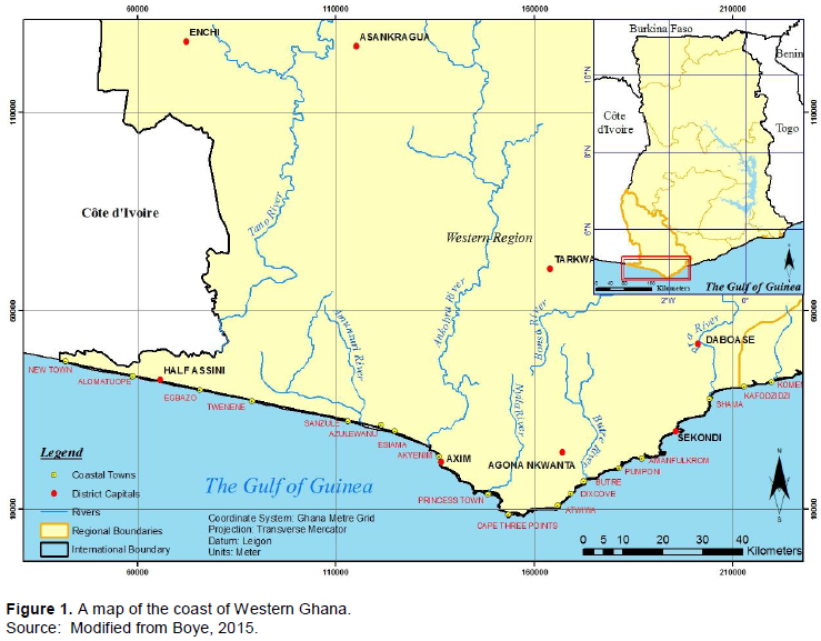
The coastal material is composed of about 60% sandy beaches and 40% composite rock/sandy beaches (Boye, 2015). The coastal material properties within the study area may be described as heterogeneous with the coastal rock types ranging from granites, granitoids, through shales, sandstones to low strength soils (Kesse, 1985). Portions of the study area are bounded by high resistant rock outcrops forming promontories giving the coast the characteristic curvilinear shape of headlands intersperse with embayment along the Eastern Section (Pra River Estuary-Ankobra River Estuary) of the study area (Figure 1). The Western section of the study area has homogeneous coastal materials, which stretches to about 100 km (Ankobra River Estuary-New Town) and it is characterised by purely sandy beaches occasionally intersected by lagoons and river inlets. The shores of the study area are nourished by numerous rivers notably the Pra, Amunsuri and the Ankobra. The sediment discharge from these rivers is distributed across the shores by the strong west to east longshore drift (Boateng, 2012).
Multi-temporal spatial shoreline dataset (1974 and 2005), hard and soft copy topographic map of the study area, river flow data, and information gathered from field reconnaissance were used for the assessment. The shoreline features were extracted from the dataset using the High Water Line (HWL) as a proxy and appended in a GIS environment. A baseline was created and orthogonal transects cast using Digital Shoreline Analysis System (Thieler et al., 2009) for the computation of the shoreline change rates for the 31 years period (that is 1974-2005). The Endpoint of Rates method (Foster and Savage, 1989; Dolan et al., 1991; Thieler et al., 2001) was adopted. Detailed discussion on the method could be found in Dean and Dalrymple (2002), Frazer et al. (2009) and Dolan et al. (1991). The Endpoint Rates and other methods such as linear regression by least square and the average of Rates methods are adopted for their accuracy since aberrations in the shoreline dataset are either excluded by the use of line of best fit (Galgano and Douglas, 2000), or checked for adherence to the minimum time criterion (Dolan et al., 1991).
From the hard and soft copies of the topographic maps of the study area, the drainage areas of the coastal rivers were digitized in a GIS environment and their catchment areas determined and validated by the manual procedure using a digital planimeter. Using available river flow data for the major rivers within the study area (Pra, Ankobra and Butre), the water discharge by the rivers were determined (Watkins and Fiddes, 1984). The peak discharge for the small basin streams was estimated from the peak stormwater runoff rates rainfall applying the Rational Method (O'Loughlin et al., 1996). The Rational Method was adopted because of its simplicity and the fact that it requires limited rainfall and drainage data. Mathematical equations for the peak flood discharge are expressed as shown in Equation 1.
Peak flood discharge Qmax=0.277CAI (1)
where Qmax is the peak flood discharge (m3/s), C the runoff coefficient of the region, A the catchment area (km²) and I is the mean intensity of rainfall in mm/h during the time of concentration.
Assuming a total storm duration for the study area, runoff volumes were computed. Complete descriptions of the Rational method have been done by Thompson (2006), Booth et al. (2002), and Kim et al. (2003). The Rational method was used because it is widely used for computing peak discharge besides it offers a simple technique for estimating discharge of small drainage basins (Cleveland et al., 2011).
The quantity of sediment load produced by small and large basin rivers in the catchment were determined by the instantaneous sediment concentration (Cs) formula (Equation 2) adopting sediment rating coefficient and exponent values developed for coastal rivers in Ghana (Akrasi, 2011). The sediment rating coefficient and exponent were obtained using measurements of suspended sediment transport for 21 monitored stations as sample sites to collate sediment yield data in south-western and coastal basin systems. The discrete data was fed into a power regression relation (Nittrouer and Viparelli, 2014) developed using continuous data to derive a sediment rating curve, which depicts the statistical relation between suspended sediment concentration and discharge as in Equation 2.
where Cs is the instantaneous sediment concentration (mg/l), Qw is the instantaneous water discharge (m3/s) and a and b are the sediment rating coefficient and exponent, respectively.
The correlation between instantaneous sediment Cs and instantaneous discharge Q are statistically significant. The approach was adopted because the collections of the instantaneous daily measurement over a period are expensive (Akrasi, 2011). Suspended sediment concentration and the discharge for large river basins in Ghana are often gauged and measured by the Water Research Institute of Ghana. Using the sediment discharge of measured rivers to estimate the unmeasured one enable the sediment load to be computed for all rivers in the study area, though not the actual measured suspended sediment load, but rather a representative estimate of the rivers under consideration (Landers, 2010).
where Q = the sediment discharge (t day¯1), Qw = total water discharge (m3/s), n= exponential and k=constant. The values obtained as sediment supplied by rivers were analyzed against their corresponding shoreline change rates at those sites.
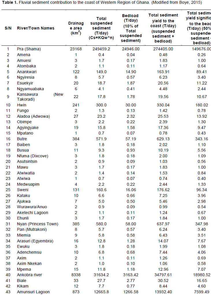
It is important to note that total sediment yield from rivers comprises suspended sediment load and the bed load. Previous studies of fluvial sediment discharge have established that in most cases the bedload of fluvial sediment supply is 10% of suspended sediment load (Walling, 1984; Boateng, 2012; Turowski et al., 2010). The assumption of 10% of suspended sediment load as bedload has been applied in this paper. Furthermore, Ayibotele and Tuffour-Darko (1979) identified from samples of 129 gauging stations that 50% of suspended sediment yield from Ghana rivers are of grain sizes less than (63 μm). The fine grain size (<63 μm) may not stay on the beach but rather may be carried offshore or to estuaries and marshes down-drift (Milliman et al., 1985; Phillips and Slattery, 2006) and therefore total sediment yield considered to be significant to the beach in the case study area represents 50% of suspended sediment yield plus the bedload from each river (Table 1).
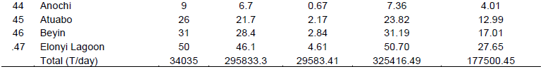
A total of 47 catchments were identified along the case study area. Table 1 shows the sediment contributions of all the 47 rivers and streams of all catchment size and their correspondent suspended sediment yield, bedload and total sediment significant to the beach all in tonnes per day. Figure 2 also shows the spatial location of each sediment input.
High suspended sediment load values were recorded for the three major rivers, namely: Pra, Ankobra and Amunsuri with values ranging between 1.2 × 10⁴ and of 2.4 × 10⁵ tonnes/day. Other rivers which supply considerable suspended sediment load are the Anankwari (149 tonnes/day), Sweni (160 tonnes/day), Hwin (300 tonnes/day), Butre (572 tonnes/day), and the Nyan (580 tonnes/day). The peak sediment load along the study area varied considerably; the portion between the Pra and Ankobra rivers, which constitute a shoreline length of about 98 km (50%) of the total study area, contained about 83% of the rivers compared with the west of Ankobra River which stretches approximately equal length of shore contains 17% of the rivers. Most of the rivers flow in the north-south direction except for the Amunsuri, which flows in a west-east direction parallel to the shore and empties its yield in a lagoon. The total sediment yield significant to the beach and thus contributing to the coastal stability of the case study area is estimated to be about 1.8 × 10⁵ with Rivers Pra and Ankobra supplying more than 50% of the total estimate. Figures 3, 4 and 5 show plot of all the rivers and lagoon inlets and their corresponding shoreline change.
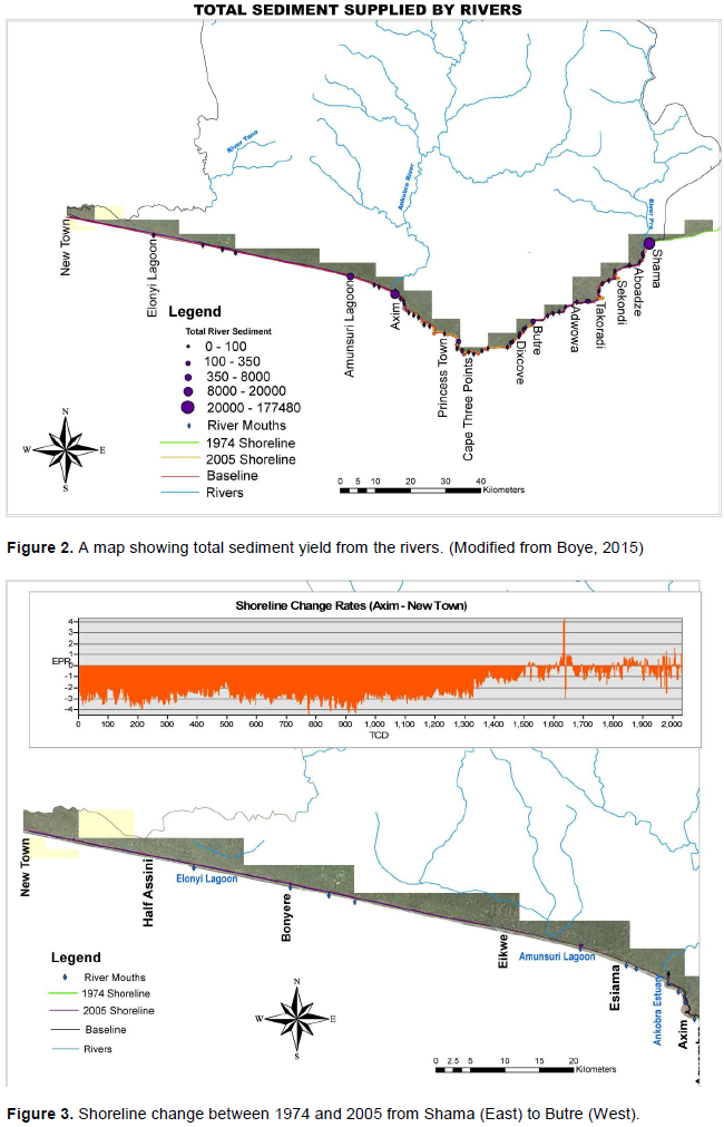
The spatiotemporal changes in shoreline at the river/stream mouths over the 31 years period of the shoreline analysis (that is 1974 – 2005) is as shown in Figure 3 to 5 have revealed minimal accretion at few sites, such as Axim (0.46 m/year) and Nfuma River mouth near Dixcove with a rate of 0.2 m/year, except for Takoradi and Sekondi harbours where expansion works had been carried out in 2004, thus high accretion values are observed at those sites. Mean shoreline change rate of -1.13 m/year and -1.28 m/year were recorded at the eastern (Shama-Butre) and the western (Butre-Axim) sections, but a relatively high value of -2.00 m/year was registered for the third section (Axim-New Town) (Figure 2). A mean shoreline change value of -1.62 m was recorded at the entire study area over a period of 31 years. This confirms Boateng (2012) observation that the western coast of Ghana experiences less erosion than the rest of Ghana’s coastline. The results from Figures 3 to 5 reveal that there is either less recession or accretion at all the coastal areas that received significant river discharge (Figure 2). This could be attributed to the significant fluvial sediment supply to the area.

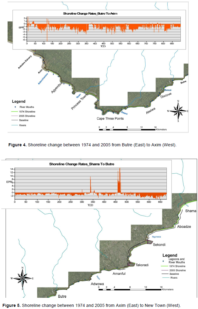
The study area is adequately nourished with sediment produced by the 26 main rivers in the catchment from which about 1.8 × 10⁵ tonnes of sediment reaches the coast daily. The variable quantities of the fluvial sediment supplied by the various rivers are shown spatially by the graduated symbols at the river mouths as shown in Figure 2, from where they are distributed along the shores (Peduzzi, 2014). It was observed from the shoreline change analysis that minimal accretion or recession was recorded at the river mouths, which gives an indication that significant amount of the sediment supplied is retained near the river mouths. This finding confirms Qiao et al. (2010) observation of high suspended sediment concentration at the mouth of the Yellow River in their study of the distribution and transport of suspended sediment from the Yellow River. Since suspended sediment constitutes about 90% of the total fluvial sediment supplied in the study area it is reasonable to conceive that the quantity of sediment supplied at the river mouths tend to decrease as one moves farther from the river mouths. This pattern is synonymous with the shoreline change at the study site. The accumulation of sediment supplied by rivers along the beach seems to be linked with the shoreline change rates at those sites, which therefore confirms that fluvial sediment provides materials that stabilize the beaches as well as the shoreline.
The fine grain size below 63 μm may not stay on the beach because they are very fine and may be carried away in suspension to offshore or to estuaries and marshes downdrift. However, this interpretation has been challenged by Cooper and Pontee (2006) who argued that the fine suspended sediment that is deposited in saltmarshes and tidal mudflats downdrift has an important influence on the stability of the coastal environment. The rate of coastal sediment transport across the shore usually determines the actual sediment that is retained at any given section of the shore. Where the sediment supply by rivers exceed sediment transported across shore the beach grows subsequently the shoreline accretes, but where there is a deficiency in the sediment supply the beach dwindles, thus shoreline recession is recorded.
We have identified that rivers with medium catchment size (between 100 and 500 km2) such as the Nyan, Butre, Hwin, Sweni and Anankwari supply significant quantities of sediment and tend to have wide and stable beaches compared to the larger catchments like Rivers Pra and Ankobra. This phenomenon is based on the fact that rivers with medium basins have steeper gradients, less storage capacity, less abraded materials, and greater response to episodic rainfall events, such as floods and landslides (Milliman et al., 1999).
The shoreline in the study area is changing at variable rates consistent with the variability of sediment supply by rivers. Isolated parts of the shore recorded minimal accretion; other portions are categorized as experiencing minimal, moderate, high or extreme levels of shoreline change rates according to European standards
(Kotsovinos and Georgoulas, 2008). Areas such as Ngyiresia and Nfuma (Dixcove) recorded minimal accretion of 0.16 and 0.38 m/year, respectively. This may be attributed to the fact that sediment supplied by rivers at the section exceeds those transported across the shores by the physical processes. Rivers that nourish these sections have small drainage areas and therefore supply relatively coarser particle sizes of sediment (Buffington et al., 2002) that stays on the beach. In addition, the shoreline between Axim and Shama comprises alternating bays that are enclosed by headlands. The headlands facilitate the interception of the west to east longshore drift of sediment, which is stored in the alternating bays. Hence, erosion at the bay frontages is relatively low compared to the areas outside the bays (Figures 3 to 5).
Sediment supplied by the rivers nourish the beach and maintain beach stability. However, there are two major threats (beach sand mining and Dam construction) that may have a negative impact on the relative stable shoreline if sustainable measures are not taken now. Historically, the coastline of the western region of Ghana has been rural and less developed. However, the recent oil find in the region has led to increasing development in the area. The local people have resorted to the illegal practice of excavating beach sand for construction. This practice could lead to increase in coastal erosion and shoreline recession if not checked (Jonah et al., 2017). The second factor which poses a threat to the coastal stability of Ghana’s western coastline is the proposal to dam both Ankobra and Pra Rivers to develop hydroelectric power to support the growing energy demand in the region (Kufour, 2007). Hydro-power is one of the recommended clean energy strategies to reduce the effects of climate change. However, the development of the dam to generate hydro-power tends to impound and reduce fluvial sediment supply to the coast drastically (Ly, 1980; Boateng et al., 2012). Hence, the proposed development of dams on Pra and Ankobra Rivers could have a seriously deleterious effect on the coastline if appropriate interventions are not developed to compensate for the loss of sediment supply from the two rivers.
CONCLUSION AND RECOMMENDATIONS
The study has established the fact that significant quantities of sediments are discharged by rivers and streams within the study area. The sizes of the catchment areas, as well as the slope of the rivers, influence the quantity and particle size of sediment supply by a river.
The study has also found that fluvial sediment discharge from the coastal rivers in the study area supplies significant sediment to nourish the beaches and make immensely contribute to coastal stability. This implies that fluvial sediment plays a vital role in the sediment budget of the study area. It was also evident that the shoreline change rates along the shores of rivers/lagoons inlets and areas with embayment had less erosion than other sections of the shoreline without these features.
The paper has clearly demonstrated that the coast in the case study area and elsewhere may be closely connected to the hinterland through fluvial sediment discharge. Therefore, any artificial interventions (dam and flood alleviation schemes) on coastal rivers in the hinterland could have serious repercussion on coastal stability. In addition, bad practices, like beach sand mining and building of ad-hoc hard-coastal defence structures without proper consideration of the knock-on effect down-drift could have a serious effect on coastal stability. Coastal and river catchment managers should, therefore, consider the coastal rivers and the coast as a connected system, hence, coastal and river management policies must be very well evaluated and harmonized to reduce knock-on effect.
The authors have not declared any conflict of interests.
REFERENCES
|
Akrasi SA (2011). Sediment Discharges from Ghanaian Rivers into the Sea. West African Journal of Applied Ecology 18:1-13.
Crossref
|
|
|
|
Ayibotele NB, Tuffour-Darko T (1979). Sediment loads in the southern rivers of Ghana. Water Resources Research Unit (Council for Scientific and Industrial Research).
|
|
|
|
|
Berkun M (2010). Hydroelectric potential and environmental effects of multidam hydropower projects in Turkey. Energy for Sustainable Development 14(4):320-329.
Crossref
|
|
|
|
|
Bittencourt CASP, Dominguez JML, Martin L, Silva IR (2005). Longshore transport on the northeastern Brazilian coast and implications to the location of large-scale accumulative and erosive zones: An overview. Marine Geology 219(4):219-234.
Crossref
|
|
|
|
|
Boateng I (2012). An application of GIS and coastal geomorphology for large scale assessment of coastal erosion and management: a case study of Ghana. Journal of coastal conservation 16(3):383-97.
Crossref
|
|
|
|
|
Boateng I, Bray M, Hooke J (2012). Estimating the fluvial sediment input to the coastal sediment budget: A case study of Ghana. Geomorphology 138:100-110.
Crossref
|
|
|
|
|
Boateng I, Wiafe G, Jayson-Quashigah P (2017). Mapping Vulnerability and Risk of Ghana's Coastline to Sea Level Rise. Marine Geodesy 40(1):23-39.
Crossref
|
|
|
|
|
Booth DB, Hartley D, Jackson R (2002). Forest cover, imperviousâ€surface area, and the mitigation of stormwater impacts. Journal of the American Water Resources Association 38(3):835-845.
Crossref
|
|
|
|
|
Boye CB. (2015). Causes and Trends in Shoreline Change in the Western Region of Ghana. Ph.D thesis. University of Ghana, Ghana.
|
|
|
|
|
Brandt SA (2000). Classification of geomorphological effects downstream of dams. Catena 40(4):375-401.
Crossref
|
|
|
|
|
Buffington JM, Lisle TE, Woodsmith RD, Hilton S (2002). Controls on the size and occurrence of pools in coarse-grained forest rivers. River Research and Applications 18:507-531.
Crossref
|
|
|
|
|
Cleveland TG, Thompson DB, Fang X (2011). Use of the Rational and Modified Rational Method for Hydraulic Design. Alexandria, USA: Texas Tech University College of Engineering.
|
|
|
|
|
Cooper NJ, Pethick JS (2005). Sediment budget approach to addressing coastal erosion problems in St. Ouen's Bay, Jersey, Channel Islands. Journal of Coastal Research:112-122.
Crossref
|
|
|
|
|
Cooper NJ, Pontee NI (2006). Appraisal and evolution of the littoral 'sediment cell' concept in applied coastal management: experiences from England and Wales. Journal of Ocean and Coastal Management 49:498-510.
Crossref
|
|
|
|
|
Darby SE, Hackney CR, Leyland J, Kummu M, Lauri H, Parsons DR, Aalto R (2016). Fluvial sediment supply to a mega-delta reduced by shifting tropical-cyclone activity. Nature 539(7628):276-279.
Crossref
|
|
|
|
|
Dean R, Dalrymple RA (2002). Coastal processes with engineering applications. Cambridge, UK: University Press.
Crossref
|
|
|
|
|
Dolan R, Fenster MS, Holme SJ (1991). Temporal Analysis of Shoreline Recession and Accretion. Journal of Coastal Research, 7(3):723-744.
|
|
|
|
|
Foster ER, Savage RJ (1989). Methods of historical shoreline analysis Coastal zone. American Society of Civil Engineers 5:4434-4448.
|
|
|
|
|
Frazer LN, Genz AS, Fletcher CHS (2009). Toward parsimony in shoreline change Prediction (I): Basis Function Methods. Journal of Coastal Research 25(2):366-379.
Crossref
|
|
|
|
|
Galgano FA, Douglas BC (2000). Shoreline Position Prediction: Methods and Errors. Environmental Geosciences 7(1):1-10.
Crossref
|
|
|
|
|
IRTCES (2011). Sediment Issues and Sediment Management in Large River Basins Interim Case Study Synthesis Report International Sediment Initiative Technical Document in Hydrology. Retrieved from Beijing: United Nations Education.
|
|
|
|
|
Jonah FE, Adams O, Aheto DW, Jonah RE, Mensah EA (2017). Coastal zone management challenges in Ghana: issues associated with coastal sediment mining. Journal of Coastal Conservation 21(3):343-53.
Crossref
|
|
|
|
|
Kasım Y, Mahmut B, Reit G, Mehmet M (2010). A comparative Study on Prediction of Sediment yield in the Euphrates basin. International Journal of Physical Sciences 5(5):518-534.
|
|
|
|
|
Kesse GO (1985). The Mineral and rock Resources of Ghana. Balkema, Rotterdam: Ghana Geological Survey.
|
|
|
|
|
Kim H, Seagren EA, Davis AP (2003). Engineered bio-retention for removal of nitrate from stormwater runoff. Water Environment Research 75(4):355-367.
Crossref
|
|
|
|
|
Kotsovinos N, Georgoulas A (2008). Maximum fluctuation of the shoreline due to tidal fluctuation, In: beach erosion monitoring-results from BEACHMED-e/OpTIMAL Project.
|
|
|
|
|
Kufuor JA (2007). Speech by J. A. Kufuor, President of the Republic of Ghana at the sod-cutting ceremony for the commencement of the Bui hydro-electric power project.
|
|
|
|
|
Landers MN (2010). Review of Methods to Estimate Fluvial Suspended Sediment Characteristics from Acoustic Surrogate Metrics. In Joint Federal Interagency Conference 2:1-2.
|
|
|
|
|
Ly CK (1980). The role of the Akosombo Dam on the Volta River in causing coastal erosion in Central and Eastern Ghana (West Africa). Marine Geology 37:323-332.
Crossref
|
|
|
|
|
Milliman JD (1990). Fluvial sediment in coastal seas: flux and fate. Nature and Resources 26(4):12-22.
|
|
|
|
|
Milliman JD, Farnsworth KL, Albertin CS (1999). Flux and fate of fluvial sediments leaving large islands in the East Indies. Journal of Sea Research 41:97-107.
Crossref
|
|
|
|
|
Milliman JD, Huang-Ting S, Zuo-Sheng Y, Mead, RH (1985). Transport and deposition of river sediment in the Changjiang estuary and adjacent continental shelf. Continental Shelf Research 4(1-2):37-45.
Crossref
|
|
|
|
|
Milliman JD, Rutkowski C, Meybeck M (1995). River Discharge to the Sea: A Global River Index Land-Ocean Interaction in the Coastal Zone (LOICZ).
|
|
|
|
|
Milliman JD, Syvitski JPM (1992). Geomorphic/Tectonic control of sediment discharge to the ocean: the importance of small mountainous rivers. Journal of Geology pp. 525-544.
Crossref
|
|
|
|
|
Nittrouer JA, Viparelli E (2014). Sand as a stable and sustainable resource for nourishing the Mississippi River delta. Nature Geoscience 7:350-354.
Crossref
|
|
|
|
|
O'Loughlin G, Huber W, Chocat B (1996). Rainfall-runoff processes and modelling. Journal of hydraulic research 34(6):733-751.
Crossref
|
|
|
|
|
Owens PN (2007). Background and summary of this issue on sediment linkages 273-276.
Crossref
|
|
|
|
|
Peduzzi P (2014). Sand, rarer than one thinks. Environmental Development 1:208-218.
Crossref
|
|
|
|
|
Phillips JD, Slattery MC (2006). Sediment storage, sea level, and sediment delivery to the ocean by coastal plain river. Progress in Physical Geography 30(4):513-530.
Crossref
|
|
|
|
|
Pottinger L (1996). Environmental Impacts of Large Dams, African Examples' International Rives: 30 Years Protecting People, Water and Life.
|
|
|
|
|
Qiao S, Shi X, Zhu A, Liu Y, Bi N, Fang X, Yang G (2010). Distribution and transport of suspended sediments off the Yellow River (Huanghe) mouth and the nearby Bohai Sea. Estuarine, Coastal and Shelf Science 86(3):337-344.
Crossref
|
|
|
|
|
Thieler ER, Himmelstoss EA, Zichichi JL, Ergul A (2009). The Digital Shoreline Analysis System (DSAS) version 4.0-an ArcGIS extension for calculating shoreline change (No. 2008-1278). US Geological Survey.
Crossref
|
|
|
|
|
Thieler ER, O'Connell JF, Schupp CA (2001). The Massachusetts Shoreline change project: 1800 to 1994. US Geological Survey Administrative Report.
|
|
|
|
|
Thompson BD (2006). Engineering Hydrology, Rational Method. Texas Tech University: Civil Engineering Department.
|
|
|
|
|
Turowski JM, Rickenmann D, Dadson SJ (2010). The partitioning of the total sediment load of a river into suspended load and bedload: a review of empirical data. Sedimentology 57(4):1126-46.
Crossref
|
|
|
|
|
Walling DE (2006). Human impact on land-ocean sediment transfer by the world's rivers. Geomorphology 79(3):192-216.
Crossref
|
|
|
|
|
Watkins LH, Fiddes D (1984). Highway and urban Hydrology in the Tropics. London: Pentech Press.
|
|
|
|
|
Wellens-Mensah J, Armah AK, Amlalo DS, Tetteh K (2002). Development and protection of the coastal and marine environment in Sub-Saharan Africa: Ghana. Retrieved from Nairobi:
|
|
|
|
|
Wiafe G, Boateng I, Addo-Appeaning K, Quashigah PN, Ababio SD, Sowah L (2013). Handbook of Coastal Processes and Management in Ghana. Accra, Ghana: The Choir Press in conjunction with Coastal Processes Research Group.
|
|
|
|
|
Willis CM, Griggs GB (2003). Reductions in Fluvial Sediment Discharge by Coastal Dams in California and Implications for Beach Sustainability. The Journal of Geology 111(2):167-182.
Crossref
|
|
|
|
|
Yu J, Fu Y, Li Y, Han G, Wang Y, Zhou D, Sun WD, Gao YJ, Meixner FX (2011). Effects of water discharge and sediment load on evolution of modern Yellow River Delta, China, over the period from 1976 to 2009. Biogeosciences 8:2427-2435.
Crossref
|
|