ABSTRACT
Vertical electrical sounding (VES) employing Schlumberger electrode configuration was carried out in order to study the groundwater flow potential in Makurdi, north central Nigeria. This was done in thirty locations to determine the aquifer resistivity, thickness, longitudinal conductance, hydraulic conductivity and transmissivity. From the result, the averages and ranges of these parameters were determined. 2D contour maps of aquifer resistivity, aquifer thickness, longitudinal conductance, hydraulic conductivity and transmissivity were drawn. The distribution of thickness and transmissivity maps provided a means of identifying areas where aquiferous zone is prolific. The classification of the groundwater potential shows 3.3% very low, 26.7% low, 66.7% moderate and 3.3% high potentials. Knowledge of hydraulic conductivity and transmissivity is necessary for the determination of groundwater flow potential through an aquifer.
Key words: Aquifer resistivity, hydraulic conductivity, transmissivity, longitudinal conductance, vertical electrical sounding, thickness, Makurdi.
Groundwater is that water found within the saturated voids beneath the ground. It is the major source of potable water supply in the Makurdi area. Groundwater is the subsurface water which fully saturates the pores and behaves in response to gravitational force (Straher, 1973). Water is an indispensable resource and the concern of many earth scientists and researchers have been on the acquisition of a reliable source of drinking water (Akinbinu, 2015). Surface and groundwater resources are abundant in Nigeria. The water resources master plan for Nigeria which was prepared by the Japan International Co-operation Agency (JICA) in 2006 indicates an estimated surface water resource of about .67 and groundwater storage of about (Oteze, 2006). These figures greatly outweigh the country’s total water demand of about (Oteze, 2006). Surface water is frequently found to be grossly degraded in quality because of its exposure to physical, biological or chemical contaminants (Edet, 2004). Groundwater on its own has less of a degree of contamination when compared with surface water and this has contributed to an increase in the number of boreholes drilled by the government, non-governmental organizations and individuals in Nigeria.
The availability and quality of groundwater in Makurdi, the capital town of Benue State, North Central Nigeria, are determined from a number of composite factors such as porosity and permeability. The Public Water Works which supplied water to all parts of the town has become dysfunctional and moribund. Most residents of the town have adjusted to providing their own domestic supplies by use of shallow hand dug wells (approximately 10 m deep) which are often poorly completed. The Makurdi Sandstone which is the main aquifer that supplies water into wells for abstraction is frequently indurated to the extent that well failure is always recorded when it is encountered using manual digging as is the case with all shallow boreholes. The wells are neither cased nor are they properly capped after completion. The immediate surroundings of the wells are inadequately sequestered from unsanitary conditions. Since there was no profes-sional prospecting for the location of water bearing sediments, some of the boreholes have either failed entirely or partially because of uncoordinated drillings. When the rate at which a well is discharge is greater than the rate at which it is recharge, then the well may fail (Davison et al., 1997). The nature of the aquifer is a function of subsurface geological composition that play an important role in determining the circulation of water from the surface (infiltration) to subsurface water through recharge processes (Bashir et al., 2014).
It is believed that the thickness and the other properties of the aquifers where the water is tapped from are very important and can only be made known through geophysical surveys. According to Makinde (2002), groundwater is related to the nature of earth rocks. Information on these rocks can be provided by a number of physical techniques which includes: seismic reflection and refraction, electrical resistivity techniques, well-logging etc. The vertical electrical sounding (VES) method is a depth sounding galvanic method and has proved very useful in groundwater studies due to simplicity and reliability of the method. The electrical resistivity of rock is a property which depends on lithology and fluid contents.
The basement complex terrain has many challenges as regards to groundwater potential evaluation and it explains why yield in basement complex is lower than well yield in sedimentary terrain. Groundwater usually occurs in discontinuous aquifers in basement complex area. Using electrical resistivity method and borehole lithologic logs, Dan-Hasssan (2001) depicted that the aquifers of the basement complex rocks of north central Nigeria are predominantly weathered overburden aquifers. As the resistivity of sediments and rocks are controlled by the amount of water present and the salinity (electrolytic conduction), clay mineral, fine grained or increasing silt or clay content in poorly sorted rocks or sediments will reduce resistivity (Burger,1992). Resistivity imaging method has improved the chance of drilling successfully by identifying the fractured and weathered zones in hard and compacted terrain (Loke, 2001). The flow potential of groundwater is a measure of the transmissivity of the aquifer, which is the product of the aquifer thickness and hydraulic conductivity. The knowledge of aquifer characteristics is important in determining the natural flow of water through an aquifer, it response to withdrawal of fluid, the availability, quantity and quality of the groundwater. Hydraulic conductivity (k) is a measure of the ease with which a fluid will pass through a medium (Heigold et al., 1979). By definition, hydraulic conductivity depends not only upon the medium but also on the fluid (Heigold et al., 1979).
Geophysical site investigations for groundwater exploration are scanty and inadequate in the study area and the hydrogeology is not well developed. The present study is therefore aimed at evaluating the groundwater condition and the nature of the subsurface layers, which will constitute the baseline information about the hydrogeology of the area.
Location and geology of the study area
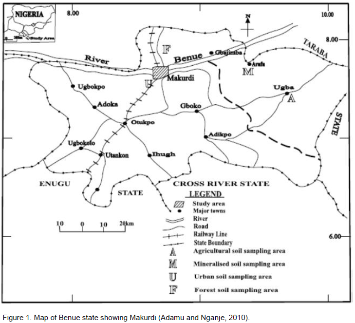
The study area is Makurdi, the Benue State Capital, North central, Nigeria (Figure 1). It lies between latitudes 7°40’N and 7°50’N of the Equator and between longitude 8°20’E and 8°40’E of the Greenwich Meridian, covering a total area of about 670 km². Makurdi lies within the Guinea savannah vegetation zone with a few patches of forests. The annual rainfall ranges between 1,500 to 2,000 mm with its peak rainfall in the month of July. Temperatures in March and April are about 38 and 48°C, respectively, while in December/January, the temperature is 27°C (Benue State Water Supply and Sanitation Agency, 2008). Makurdi belongs to the Makurdi Formation which overlies the Albian Shale. It consists of thick current bedded coarse grained deposits. The Makurdi sandstone has a thickness of about 900 m (Offodile, 1976). The southern part of the Benue valley is generally gently undulating and punctuated by a few low hills. But toward the northeast, the relief is exaggerated by hills like the Lammuder and Ligri hills, which rise up to 600 m above sea level. The drainage consists of rivers which meander into the River Benue from the north and south directions.
Geologically, the Benue valley consists of a linear stretch of sedimentary basin running from about the present confluence of the Niger and the Benue rivers to the north east, and is bounded roughly by the Basement Complex areas in the north and south of the River Benue. The elongated trough-like basin is continuous with the coastal basin, and in fact, has been correctly described as the longest arm of the Nigerian coastal basin (Offodile, 2002) (Figure 1).
Different types of geological, geotechnical and environmental problems have been studied using surface electrical resistivity methods. The resistivity survey in the study area was completed with thirty Schlumberger electrical sounding (VES) (Figure 2). PZ-02 resistivity meter was used with maximum current electrodes spacing

of 100.0 m,

of 15.0 m. The resistances of the subsurface were measured and recorded against the appropriate potential and current electrodes separation. The depth of penetration is proportional to the separation between the electrodes in homogeneous ground, and varying the electrodes separation provides information about the stratification of the ground (Dahlin, 2001). This method can be used in groundwater to determine depth, thickness and boundary of an aquifer (Zohdy, 1969). The Schlumberger electrode configuration was performed using the vertical electrical sounding field

procedure to assess the electrical resistivity of the subsurface and the thickness of the aquifer. The apparent resistivity

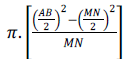
was determined using
Where, AB is the distance between the two current electrodes, MN is the distance between the potential electrodes, and

is the apparent electrical resistance measured from the equipment. The equation can be simplified to
Where, K is the geometric factor given by
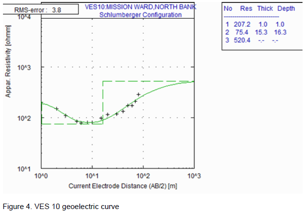
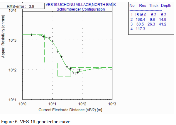
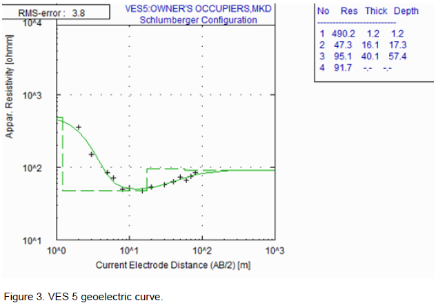
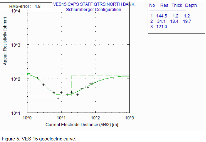
Using the conventional partial curve matching technique with two-layer master curves in conjunction with auxiliary point diagrams (Orellana and Mooney, 1966), the initial estimates of VES data was achieved. From this, estimates of layer resistivities and thicknesses were obtained which served as starting points for computer-assisted interpretation. The conventional curves and auxiliary point diagrams (theoretical curves) used in the interpretation helped in obtaining a good fit between the observed field curves and the theoretical curves during total and partial matching. The computer software program WINRESIST was used and the data sets obtained from the manual interpretation stage were keyed as inputs into the computer modeling software (WINRESIST) to generate data for the estimated model (Figures 3 to 6). According to Heigold et al. (1979), hydraulic conductivity can be determined using:


Where, K is the hydraulic conductivity and

is the aquifer resistivity.
The transmissivity values were calculated using (Todd, 1980):
Where, T is transmissivity, K is hydraulic conductivity and h is aquifer thickness. This provides a general idea of the water-producing capabilities of aquifer from surficial electrical methods.
The longitudinal conductance (S) was calculated thus:
Where, h is layer thickness and ρ is layer resistivity.
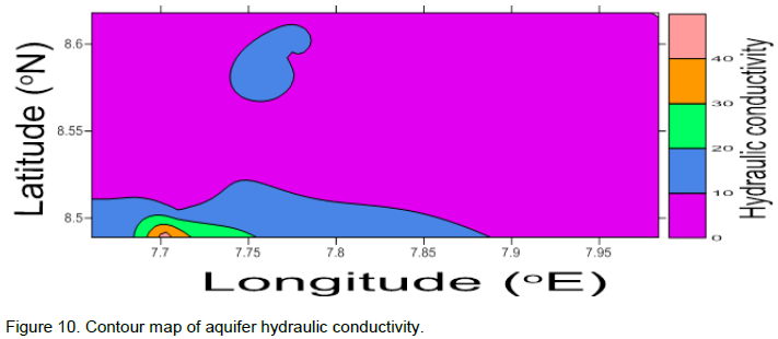
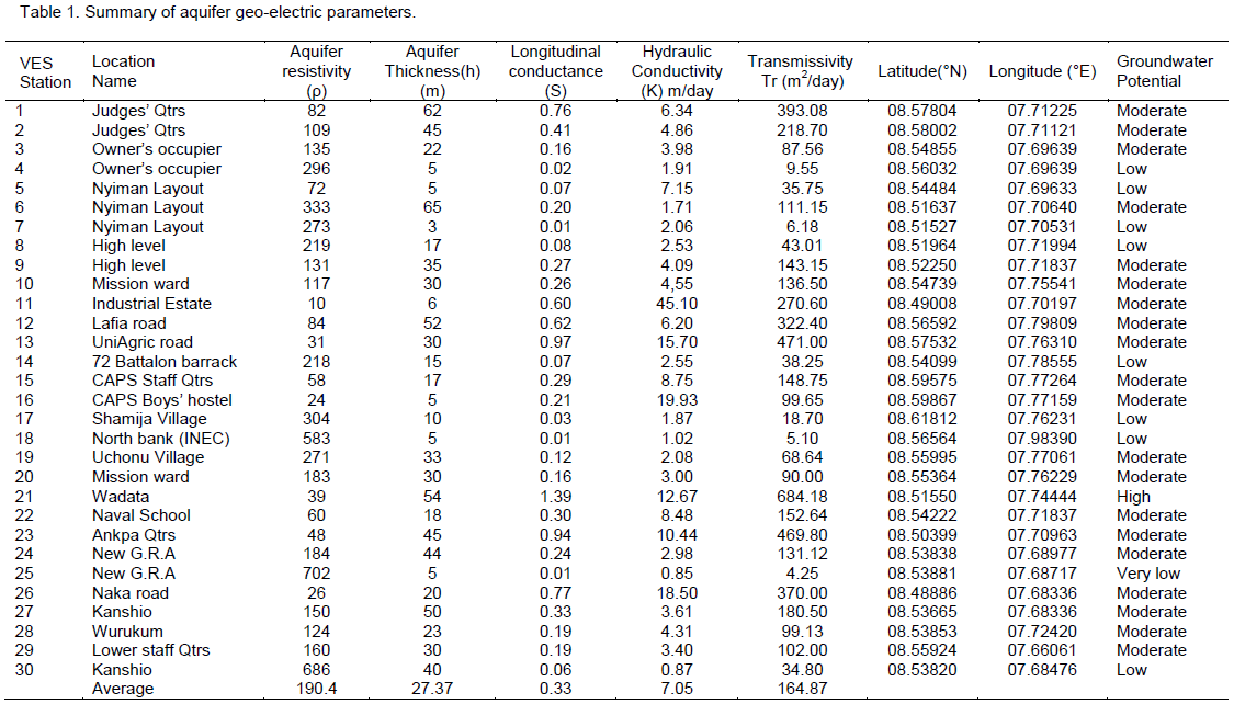
The field results obtained within the survey area is presented in Table 1. The interpretation of the data identified aquifer layers at various sounding points showing the variation of aquifer resistivity and thickness due to lithologic composition, from which the longitudinal conductance, hydraulic conductivity and transmissivity were computed. The aquifer resistivity in the study area ranges from 10 to 702 Ωm with an average value of 190.4 Ωm. From the results obtained, aquifer thickness ranges from 5 to 65 m having an average value of 27.37 m. The high thickness values at some VES points makes it prolific and desirable. The VES with the greatest thickness of 65 m was observed at Nyiman layout while VES at Owner’s occupier, North Bank (INEC) and New G.R.A. have the thinnest of 5m. Table 1 also gives the result of hydraulic conductivity (K), transmissivity (Tr) and Longitudinal conductance (S). It gives the range of longitudinal conductance from 0.01 to 0.97 , the average value been 0.33 . Most of the VES points in the study area have values less than the good protective aquifer range of 0.7 .0, thus indicating that the aquifers are unprotected. The result gives the hydraulic conductivity ranging from 0.85 to 45.10 m/day with an average value of 7.05 m/day. The average theoretical value of hydraulic conductivity given by Niwas and Singhal (1981) is 8.64m/day for pure sand and gravel, hence our value falls below this value, indicating that
Vertical electrical sounding (VES).
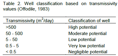
the study area is fraught with argillaceous bands of clay. Transmissivity values and its variation within the geologic formation was calculated and is also presented in Table 1, and interpreted using Table 2 (Offodile, 1983) for classification of well potential.
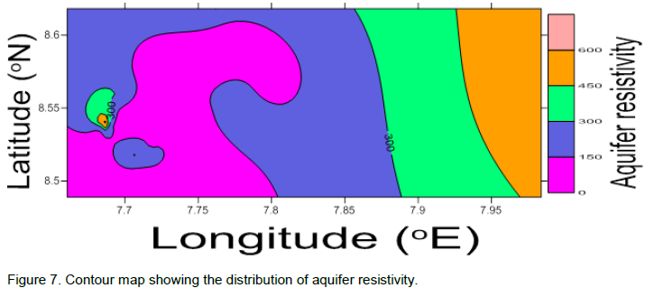
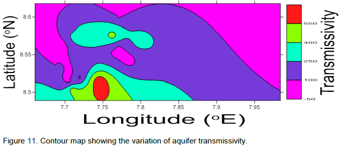
The transmissivity values range from 4.25 to 684.18 m2/day, the average value been 164.87 m2/day. The areas with high transmissivity can be attributed to having thick aquifer sand. The aquifer in the study area can be delineated as unconfined since it has non-porous layers above and below the aquifer zone. From the results of geoelectric parameters, the 2D contour maps were drawn to show the variation of the geoelectric parameters. Figure 7 is a contour map showing

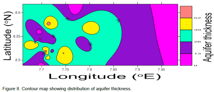
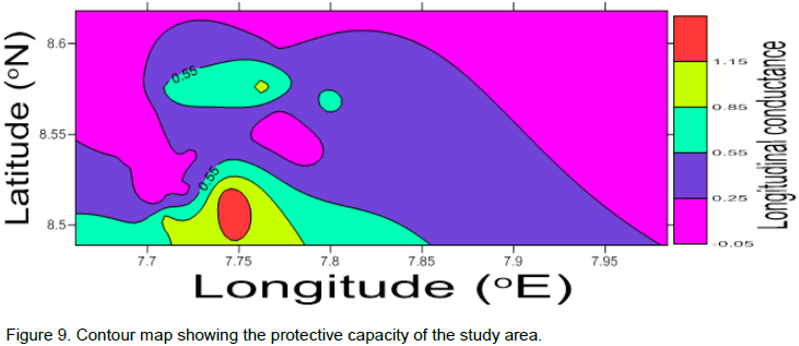
the distribution of aquifer resistivity as it decreases from east to west. This suggest that zones with low resistivity values will have high conductive geomaterials, as such poor groundwater quality. Figure 8 shows the distribution of aquifer thickness across the study area. It is oberved that the eastern part of the study area have low aquifer thickness which extends northwards and can also be observed in parts of the western zone, thus indicating that thickness is not a major determining factor for resistivity. The longitudinal conductance map (Figure 9) shows a decrease of longitudinal conductance from south across the northwest through the northeast and southeast. It can be inferred that the zones with low longitudinal conductance


values are vulnerable to contamination and thus are highly conductive as a result of seepage of contaminant fluid into the groundwater system. Hydraulic conductivity is proportional to permeability. High permeability will be observed in aquifer zone with high hydraulic conductivity and also contaminants will be easily circulated. The contour map, Figure 10, shows low hydraulic conductivity observed in most parts of the study area and high values of hydraulic conductivity observed in the extreme southwest, it can be inferred that low permeability is dominant in the study area. For characterization of rocks as a water conducting media, transmissivity is a major property (Fatoba et al., 2014). The contour map, Figure 11, shows that high transmissivity is obtainable in the southwest and decreases northwards across the eastern part of the study area. It can be inferred that aquifer productivity will be high in the southwestern part of the study area. Groundwater potential is a function of complex inter-relationship between geology, physiogra-phy, groundwater flow pattern, recharge and discharge processes (Ezeh, 2002). It is also deduced that ground-water flow potential increases as transmissivity and longitudinal conductance increases.
The study area is characterised by very low, low, moderate and high groundwater flow potential. The high groundwater potential is observed at VES 21 (Wadata).
The high groundwater flow potential is favourable for sustainable groundwater development.
Thirty (30) VES have been used to evaluate the subsurface hydrogeological conditions in Makurdi, Benue state, using geoelectric parameters to characterise the groundwater conditions of the region. From the interpreted results, longitudinal conductance, hydraulic conductivity and transmissivity were calculated. These parameters were mapped to show lateral and longitudinal distributions of thicknesses, hydraulic conductivity and transmissivity within the water bearing geomaterials. The groundwater flow potential is affected by aquifer thickness and hydraulic conductivity. The flow potential shows the study area to have 3.3% very low potential, 26.7% low potential, 66.7% moderate potential and 3.3% high potential. The transmissivity increases towards the southwestern part of the study area, thus, the southwestern part have high groundwater flow potential. The point with the lowest hydraulic conductivity (0.85 m/day) has the lowest transmissivity (4.25 m2/day) which gives the lowest well potential. Transmissivity values are suitable for sustainable groundwater development and zones with high yield have been determined for future development and for choosing the drilling sites.
The authors have not declared any conflict of interests.
The authors are grateful to Mr Victor Omonona of Department of Geology, University of Nigeria, Nsukka, for his useful contributions.
REFERENCES
Akinbinu VA (2015). Delineation of saline water intrusion to safe-inland groundwater resource. Ocean Coastal Manage. 116: 162-168.
Crossref |
|
|
Bashir IY, Izham MY, Main R (2014). Vertical electrical sounding investigation of aquifer composition and its potential to yield groundwater in some selected Towns in Bida Basin of North Central Nigeria. J. Geogr. Geol. 6(1):60-69.
Crossref |
|
|
|
Benue State Water Supply and Sanitation Agency (2008). Unpublished Report.
|
|
|
|
Burger HR (1992). Exploration Geophysics of shallow subsurface. Prentice Hall Englewood, New Jersey.
|
|
|
Dahlin T (2001). The development of DC resistivity imaging techniques. Computers and Geosciences 27: 1019-1029.
Crossref |
|
|
|
Dan-Hassan MA (2001). Determination of Geo-electric sequences and Aquifer units in part of the Basement Complex of North-Central Nigeria. Water Resources J. Nig. Asssoc. Hydrogeol. 12: 45–49.
|
|
|
|
Davison JP, Reed WE, Davis PM (1997). Exploring the Earth. New Jersey: Simon and Schuster, Viacom.
|
|
|
Edet AE (2004). Vulnerability evaluation of coastal plain sand aquifer with a case example from Calabar, South- Eastern Nigeria. J. Environ. Geol. 45: 1062–1070.
Crossref |
|
|
|
Ezeh CC (2002). Hydrogeophysical studies for the delineation of potential groundwater zones in Enugu State, Nigeria. Int. Res. J. Geol. Mining 2(5): 103-112.
|
|
|
Fatoba JO, Omolayo SD, Adigun EO (2014). Using Geoelectric Soundings for Estimation of Hydraulic Characteristics of Aquifers in the Coastal Area of Lagos, Southwestern Nigeria. Int. Letters Natural Sci. 11: 30-39.
Crossref |
|
|
Heigold PC, Gilkeson RH, Cartwright K, Reed PC (1979). Aquifer transmissivity from surficial electrical methods. Ground Water 17(4): 338-345.
Crossref |
|
|
|
Loke MH (2001). Electrical imaging surveys for environmental and engineering Studies: A Practical Guide to 2D and 3D Surveys (http://www.terrajp.co.Jp/lokenote.pdf).
|
|
|
|
Makinde V (2002). Determination of Borehole Site for Extensive Agricultural Irrigation Work. A paper presented at the 27th annual conference of Nigerian Institute of Physics, Sheraton Hotels and Towers, Abuja, Nigeria, 18th – 21st September.
|
|
|
Niwas S, Singhal DC (1981). Estimation of aquifer transmissivity from Dar Zarrouk parameters in porous media. Hydrology 50: 393–399.
Crossref |
|
|
|
Offodile ME (1976). A Review of the Geology of the Cretaceous of the Benue Valley. In: Geology of Nigeria, ed. Kogbe CA. Elizabethan Publishing Company, Lagos, Nigeria. pp. 319-330.
|
|
|
|
Offodile ME (1983). The occurrence and exploitation of groundwater in Nigeria basement complex. J. Mining Geol. 20: 131-146.
|
|
|
|
Offodile ME (2002). Groundwater study and development in Nigeria. Mecon Services Ltd., Jos, Nigeria.
|
|
|
|
Orellana E, Mooney H (1966). Master Tables and Curves for VES over Layered Structures. Interciencia, Madrid, Spain.
|
|
|
Oteze OE (2006). Management approaches for Nigeria's water resources. Nigeria J. Mineral Geol. 42:21-30.
Crossref |
|
|
|
Strahler AN (1973). Introduction to Physical Geography, 3rd Edition. John Wiley and Sons. Inc., New York.
|
|
|
|
Todd DK (1980). Groundwater Hydrology, 2nd Edition. John Wiley and Sons Inc., New York.
|
|
|
Zohdy AAR (1969). The use of Schlumberger and equatorial soundings in groundwater investigations near El Paso, Texas. Geophysics 34:713-728.
Crossref |

 of 100.0 m,
 of 15.0 m. The resistances of the subsurface were measured and recorded against the appropriate potential and current electrodes separation. The depth of penetration is proportional to the separation between the electrodes in homogeneous ground, and varying the electrodes separation provides information about the stratification of the ground (Dahlin, 2001). This method can be used in groundwater to determine depth, thickness and boundary of an aquifer (Zohdy, 1969). The Schlumberger electrode configuration was performed using the vertical electrical sounding field
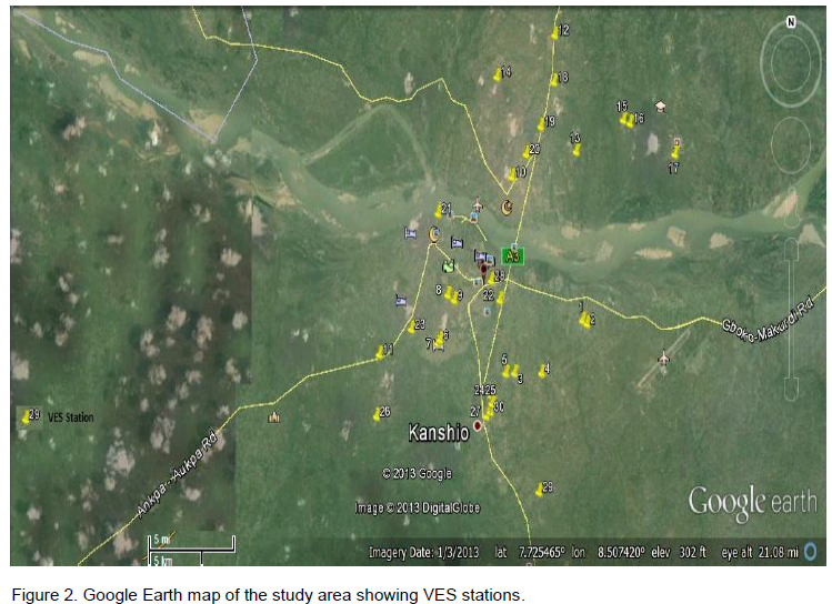
 was determined using
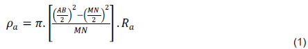
 is the apparent electrical resistance measured from the equipment. The equation can be simplified to


 is the aquifer resistivity.