Full Length Research Paper

ABSTRACT
Ecosystem modification is increasing in scale and presents the need to provide suitable conservation strategies to address dearth in policy guidelines. This work elucidated the dynamics of land use change, prevalent forest use and policy, and conservation strategy. Geometrically rectified satellite imagery data were processed for 40 years; covering three epochs. Questionnaires were distributed across four locations: 50 questionnaires per location. Results of land use change showed that vegetation cover changed from 11666.6 ha to 6067.2 ha; bare surface: 2833.8 to 1831.4 ha; built up: 1084.4 to 6378.1 ha; farmland: 81.1 to 1407.5 ha and water body: 25.5 to 5.9 ha. Built up area had much land use change gains while vegetation cover recorded much loss. Results showed that individual ownership of forest areas dominated the area. As much as 83% are not aware of rules guiding forest use, details are neither known to a vast majority (88%), nor were the people’s interests considered when making such rules (up to 84%). Principal component analysis showed strategies for promoting conservation: Making and enforcing laws ensuring forest loss reduction, regulation of forest resource use and awareness on the implications of overharvesting, establishing small reserves, planting new forests and inclusion of local people in management.
Key words: Biodiversity, forest management, land use change, tropical ecosystem.
INTRODUCTION
Ecosystems provide the basis for existence and help to achieve multiple development objectives across different landscapes. However, they are lost and modified at alarming rates such that only about 39% of land has not been affected by human use and as much as 265,000 km2 of that small proportion are lost each year (De Palma et al., 2018; Hurtt et al., 2020). Such alterations by humans has indeed led to loss much of terrestrial habitats (Estrada et al., 2017) and ultimately reduced/ affected the ecosystem services and functions of such landscapes. Indices that contribute to the decline experienced in ecosystems abound and are quite varied across spatial scales. These are mainly seen as direct drivers and are grouped into categories such as expansion of infrastructure, agricultural expansion and wood extraction (Geist and Lambin, 2001). Agriculture seems to be increasing in scale due to a growing human population with escalating need for food, energy and fibre, and consequent pressure and degradation of ecosystems (Foley et al., 2005; Drescher et al., 2016). With such trends, agriculture is seen as key driver of deforestation and loss especially in the tropics (Gibbs et al., 2010). However, since the drivers of forest loss vary regionally and change over time (Rudel et al., 2009; Hosonuma et al., 2012), more attention is needed to understand the dynamics at such scales in order to holistically address arising concerns.
While these realities in loss of biodiversity and altered ecosystems are of global concerns, the rates at which they occur vary across ecosystems and landscapes. Developing countries and landscapes are at the epicentre of such losses and equally lack detailed information on the drivers of deforestation and forest degradation (Hosonuma et al., 2012). As a result, forest losses are still ongoing at scales that are alarming with no concrete timeline or strategy on abating such trends. Much of sub-Saharan Africa including Nigeria is characterized by such scenarios and their ability to render ecosystem services- particularly the provisioning and regulating services are much hampered. Across south east Nigeria, pressure on forest landscapes appear intense and worrisome. With a high population density and a small total land area, human impacts on the ecosystem are quite visible and debilitating. Forest reserves and protected area in the zone are highly degraded, overtaken by agricultural activities, settlements and fragmented by anthropogenic activities (Igu et al., 2017). Urban development and sprawl is increasing in proportion in the area, housing development and gentrification is equally escalating in semi-urban and rural areas in the zone. These patterns of development have increased in recent times due to the return of many people from the zone from other parts of Nigeria and abroad, quest of many people to own their own homes, and the upsurge in housing estates across the region. Since these dynamics in the area have resulted to changes in land use, forest cover and natural ecosystems have continued to be altered and degraded at the same proportion.
Addressing such concerns has become pertinent in order to preserve the biodiversity as well as the ecosystem services in the region. Land use changes normally promotes the utilization or supply of certain ecosystem service(s) of interest at the expense of others (Rodriguez et al., 2006; Fedele et al., 2018) or the use of land for a certain activity at the expense of other uses. Effort to accommodate and integrate different land uses within a given area should rather be promoted; especially in areas such as the south east with small land area. Achieving such would involve holistic approaches that combine science and policy frameworks targeted at ensuring forest management even though the land will still serve other purposes. This work is a step to actualizing such initiative in a part of south east Nigeria where forest modification and land use change dynamics are intense. It will equally elucidate the realities and pattern of land use change in the zone and show realistic policies that need to be adopted to enhance ecosystem conservation and management.
MATERIALS AND METHODS
Study area
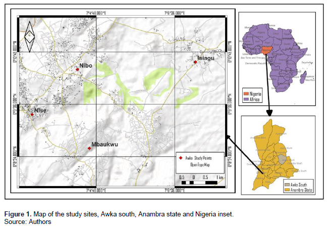
Awka south local government area (Anambra, south east Nigeria) (Figure 1) is made up of notable towns, among which is the state capital (Awka). The topography is characterized by a rugged relief that lies completely on Awka Orlu upland.
Generally, the average height ranges from 91m in the western parts to 160.2m in the eastern zone (Ojiako, 2018). The climate of the region is tropical wet and dry type following Koppen’s classification. Dry season in the zone is between November and March and the wet season is from April to October. Mean minimum and maximum temperatures are 23.5°C and 32.1°C, respectively, while the mean annual rainfall is about 1900.5m.
Awka south lies within the Anambra basin and the sedimentary rocks are mainly made up of Nkporo shale, Mamu formation, Ajali sandstone and the Nsukka formation as the main deposits. Most of the original rain forest in the region has been lost due to clearing for farming and human settlement. It is commercially defined by large rudimentary markets where varieties of goods are sold. The area serves as administrative, commercial, agricultural, educational centres; hence the dwellers are engaged in different livelihood options.
Data collection
Data used for the work are secondary data of geometrically rectified satellite imagery, results and primary data elicited from questionnaire survey conducted in the study area in 2022. The LANDSAT data were downloaded from USGS Earth Explorer for three epochs: 1981, 2001 and 2021. The Thematic Mapper (TM) image was downloaded for 5th January, 1981. The Enhance Thematic Mapper plus (ETM+) image was downloaded for 17th February, 2001 and the Operational Land Imager (OLI)/Thermal Infrared Sensor (TIRS) for 8th January, 2021.
All the images were pre-processed by the USGS to rectify any geometric or radiometric distortions of the image. This correction process employs both Digital Elevation Models and Ground Control Points to achieve a product that is free from distortions related to the Earth (curvature, rotation), satellite (attitude deviations from nominal), and sensor (view angle effects). The USGS also geometrically corrected and georeferenced both images to the WGS1984 datum and Universal Transverse Mercator (UTM) zone 32N coordinate system. For the Landsat TM, ETM+ and OLI, a False Colour Composite (FCC) operation was performed using the ArcGIS 10.4 software and the images were combined in the order of band 5, 4 and 3 for Landsat TM and ETM+ while that of Landsat OLI was in the order of band 6, 5 and 3 due to change in sensor. The images were then clipped to the boundary of AMAC to allow more detail and accuracy. A supervised classification scheme with the Interactive Selection algorithm (Muavhi, 2020) was used for the classification.
The supervised classification was performed by creating a training sample, and based on spectral signature curve, various land-use classes were created namely: Water Body, Built-up, Farmland, Bare Surface, and Vegetative Cover.
These classes were observed distinctively on the clipped image and were used for the classification. Questionnaire was used to elicit information on forest use and policy, tree management and conservation practiced in the area, as well as the needed strategies to be adopted. In order to show variations in responses from the questionnaire survey, two towns each were selected among the peri-urban (that have boundaries with Awka town) and more remote locations.
Hence, out of the eight towns within the local government, four locations (being Nibo and Nise for peri-urban and Mbaukwu and Isiagu for remote zones) (Figure 1) were selected to provide insights on the dynamics surrounding land use change and how to address the conservation and management concerns in the zone. Across each location, fifty respondents were randomly selected for the survey; hence, a total of two hundred responses were elicited. The questionnaire used was structured with options and partly with four point likert scale: strongly agree, agree, disagree and strongly disagree for conservation section.
Analysis
Descriptive statistics which includes: frequency, mean, standard deviation and total percentages were used to show the pattern of forest use and policy that exist within the region. Principal component analysis (PCA), a multivariate statistical tool was employed to simplify the relationship between large bodies of variables on methods to adopt in achieving ecosystem conservation.
RESULTS AND DISCUSSION
Overview of land use and land cover change (LULC) in the area
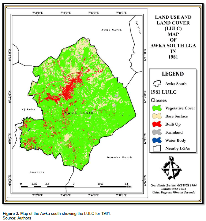
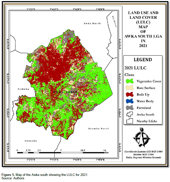
There was much change in the area from 1981-2021 (Figure 2). Figures 3 to 5 captured the map of the area and the presentation of land use and land cover for 1981, 2001 and 2021, respectively. Changes encountered within the area was seen to vary across the different LULC within the area; with vegetative cover experiencing the highest loss in extent and built up area experiencing the highest gain in extent (Figure 6).
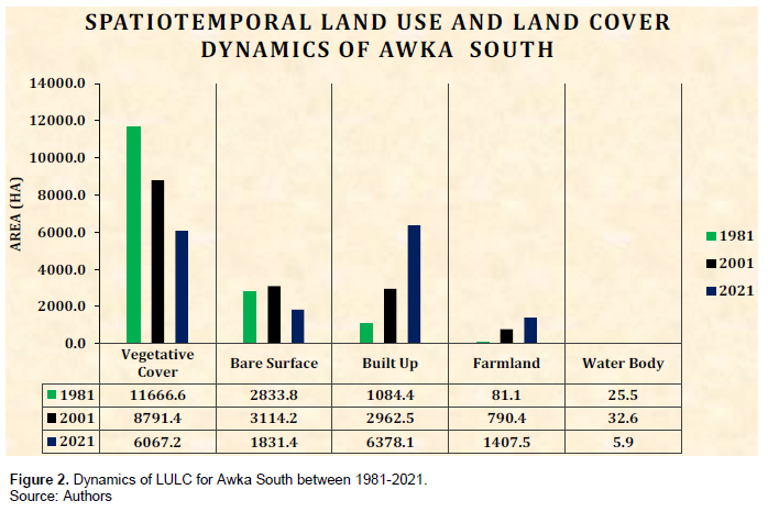


Though much of the vegetative cover (about 5599.4 ha (55.994 sq km); Figure 6) were lost over the years in the area, as much as 6067.2 ha (60.672 square km) (Figure 2) of the area still constituted vegetation. This fraction needs to be conserved. Both farmland and built up area experienced much increase (gained more land than they had initially); though not at the same proportion. Built up area had a more visible gain in land (Figure 6) and hence showed the need for targeted conservation. Similarly, in Suleja, Buba et al. (2016) revealed that built-up area which is the major land use in the zone was seen to increase from 650.60 Ha in 1980 to 3061.13 Ha in 2015. Such change (increase in built-up area) encroached into the vegetation and agricultural land use and was attributed to growth in population and proximity of the town to Abuja. Increase in built-up areas were observed in other areas that are not necessarily settlement locations in some other parts of Nigeria, such as grazing routes and agricultural locations as seen in Benue state (Odiji et al., 2022). While such zones are reserved for agriculture, built up areas were observed to grow alongside agriculture; with consequent loss of much of the forests and grasslands. Other researches on land use and cover change across Nigeria such as Fashae et al. (2022) for southwest, Echebima et al. (2019) for southeast, Bariweni and Andrew (2017) for southsouth and Nwilo et al. (2020) for northern Nigeria have shown that built up areas are increasingly becoming the dominant land use occupying much of the land areas at the expense of much decline in the (forest) ecosystems. Such trends across the nation show the much decline in vegetation and the need to conserve it accordingly.
Forest use and policy
Across the communities, much of the people (79%) accepted the view that forest ecosystems and green areas provide benefits to landscapes. However, in terms of verifying if they derived benefits from the ecosystem across the communities: 0-20% of the populace was the highest acclaimed beneficiaries (73 responses). 21-40, 41-60 and above 60% of the populace were attributed 59, 45 and 23 responses, respectively. Such opinion showed the population dynamics and orientation of the people, the urbanizing nature of the zone, and/or the reality of the degraded state of the ecosystem and inability to provide much benefit to the populace. Much of the forest areas/landscapes are owned by individuals (48%) and communities (23.5%). Such ownership structure ultimately determines to a great extent how such landscapes are managed and the rate at which become degraded. Trees and forest resources have higher tendencies of being lost or degraded in individual land holdings than would be the case in a communal land. Land fragmentation and parcelization arising from land tenure system and land inheritance would equally contribute to ecosystem degradation more in individual ownership structure. Such land tenure and parcelization concerns complicate management of such land and do not guarantee continual existence of such landscapes (D’Amato et al., 2010). Community land ownership/ management seems to have lower tendencies to parcelization and sale of land since a group of persons are involved in its decision making.
Irrespective of the ownership status of the locality, due consideration should be given to proper rules that should guide forest use. A greater proportion of the populace (83%) are not aware of any rule guiding forest use in the area and even if they exist as only 17% affirmed, the rules are not clear to up to 88% of the people. This is not surprising then that the people (84%) could attest that the interests of the people are not considered when making rules on how forests should be used. Involving local people in “shaping, implementing and evaluating programmes” tailored towards forest management, has a lot of benefits (Kimengsi and Ngu, 2022) and should be practiced in the study area as well as other landscapes. Such participation is a proven method of achieving forest management and affords the people involved the opportunity to influence programme outcomes and experience personal developmental opportunities and growth (Kimengsi et al., 2016).
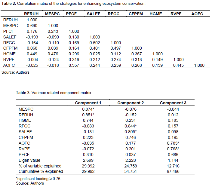
Ecosystem conservation
Much of the responses were explained by component 1 and 2; 29.992 and 24.758%, respectively and then component 3 with much lower (12.716%) percentage variable explanation. These made up 67.466% cumulative explanation for the strategies that needs to be adopted (Table 3). MESPC and RFRUH were deemed to be (in decreasing proportion) the most appropriate strategies to be adopted according to component 1 (Table 3). Making and enforcing laws to stop cutting down of trees are effective ways of promoting conservation (MESPC). It was indeed the first step that addressed the challenge of ecosystem conservation as such laws (to achieve effective conservation) may not really be in existence, and where they exist, much people are not really aware of it. There is every need to downscale existing national laws (which are mostly what exists) to regional and importantly, landscape scales to achieve conservation goals. Landscape/local scales are in sincerity where these need to be expounded to tackle ecosystem loss and efforts to achieve this. Enforcing the existing laws is as important as making the laws and will indeed require the cooperation of the populace. There is need to restrict or regulate forest resources (firewood, wild fruits, leaves, timber) use and harvest (RFRUH; 24.758%) as a means of achieving conservation. This strategy is much needed considering that forest resources are not infinite and would require being protected from degradation arising from unregulated and increasing usage. Table 1 show the label codes for strategies for enhancing ecosystem conservation. Establishing reserves in portions of the community where forests or green areas exist and compensating the land owners (RFGC), as well as setting aside some portions of land in each community for establishing (planting new) forests (SALEF) are viable steps to actualizing conservation (component 2). The idea of establishing reserves in portions of land where there are existing forests will only require changing the ownership of such portions of land (from individuals or communities to government), and so are strategies that could be easily achieved. However, for such to be seamlessly effective, due compensation for land and willingness of the owners to part with the land should not be compromised. The use of coercion or force (though legally) from government through decrees, (such as land use act and policies) are counterproductive and should not be encouraged (Igu, 2017). Conversely, establishing (planting new) forests by setting aside some portions of land in each community are viable strategies that will ensure that green zones exist at community levels. Though it will require establishing forest landscapes from the preliminary stage, it however helps to ensure that choice locations (with requisite features) that are void of land related cases and disputes are selected. More so, it would be much easier to establish species that are both most suited for each environment and most appropriate for the desired aim. RFGC and SALEF have good correlation (0.602; Table 2) and could be readily adopted in land scarce regions such as (the study area) south east Nigeria as well as in other landscapes where a myriad of land competing interests are hampering conservation efforts.
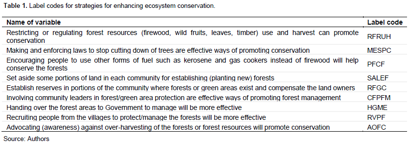
Strategies such as advocating (awareness) against over-harvesting of the forests or forest resources will promote conservation (AOFC) and recruiting people from the villages to protect/manage the forests (RVPF), are seen as being effective in achieving forest management (component 3). Advocating against overharvesting is much needed in the area, considering that much of the forest resources are already scarce and needs to be conserved by all. Such approach is vital because it will create the needed awareness on resource decline and importantly, change the mindset of the people that such resources are (erroneously) always available and can be easily replenished. Forest resources (especially across tropical landscapes) can be more effectively conserved when the populace (forest users, owners and dependents) becomes more aware on the inherent processes of decline, little resilience of most ecosystems, their services and the reality that ecosystems could be completely lost. Employing local people to protect forests in their localities are strategies that could be adopted to promote conservation efforts. Such persons are known to the people, live among them and are part of the system; hence will no doubt ensure more commitment, accountability and be more affordable. Initiative that creates employment opportunities for local persons and could be easily managed; without necessarily depending on government to fund and oversee its operations. The need to protect ecosystems from unauthorized persons and unregulated forest resource extractions are quite topical and requires a paradigm shift from the norm, if the ultimate goal of conservation is to be realized.
CONCLUSION
Forest loss is increasing in scale across much of the tropics and was seen to reflect in the study area; with much gain for built-up areas and much loss for forest/vegetation. Land ownership status, poor awareness on rules guiding forest use, poor involvement of the populace in the design and implementation of rules guiding forest use and management, were indices that contributed to vegetation loss in the region. Making and enforcing laws to stop cutting down of trees, regulating forest resource use and harvest, setting aside land and establishing reserves, were effective ways elicited for promoting conservation.
CONFLICT OF INTERESTS
The authors have not declared any conflict of interests.
ACKNOWLEDGEMENT
The authors would like to acknowledge all the participants in the survey as well as the facilitators.
REFERENCES
|
Bariweni PA, Andrew CE (2017). Land use/Land Cover Changes and Causes of Deforestation in the Wilberforce Island, Bayelsa State, Nigeria. Journal of Applied Sciences and Environmental Management 21(6). |
|
|
Buba YA, Makwin UG, Ogalla M, Okoro LO, Audu-Moses J (2016). Urban Growth and Landuse Cover Change in Nigeria using GIS and Remote Sensing Applications. Case Study of Suleja L.G.A., Niger State. International Journal of Engineering Research and Technology 5(8):124-138. |
|
|
D'Amato AW, Catanzaro PF, Damery DT, Kittredge DB, Ferrare KA (2010). Are Family Forest Owners Facing a Future in Which Forest Management Is Not Enough? Journal of Forestry 108:32-38. |
|
|
De Palma A, Ortiz KS, Martin PA, Chadwick A, Gilbert G, Bates AE, Borger L, Contu S, Hill SLL, Purvis A (2018). Challenges with inferring how land-use affects terrestrial biodiversity: study design, time, space and synthesis. Advances in Ecological Research. |
|
|
Drescher J, Rembold K, Allen K, Beckschafer P (2016). Ecological and socio-economic functions across tropical land use systems after rainforest conversion. Philosophical Transactions of the Royal Society B 371:20150275. |
|
|
Echebima SI, Obafemi AA, Ndukwu BC (2019). Assessment and Trend of Land Cover Land Use Changes in Owerri and Environs, South Eastern Nigeria. Natural Resources 10(7). |
|
|
Estrada A, Garber PA, Rylands AB, Roos C, Fernandez-Dunque E, Di Fiore A, Nekaris AI, Nijman V, Heymann EW, Lambert JE, Rovero F, Barelli C, Setchell JM, Gillespie TR, Mittermeier RA, Arregoitia LV, de Guinea M, Gouveia S, Dobrovolski R, Shanee S, Shanee N, Boyle SA, Fuentes A, MacKinnon KC, Amato KR, Meyer ALS, Wich S, Sussman W, Pan R, Kone I, Li B (2017). Impending extinction crisis of the world's primates: why primates matter. Science Advances 3:e1600946. |
|
|
Fashae OA, Tijani MN, Adekoya AE, Tijani SA, Adagbasa EG, Aladejana JA (2022). Comparative Assessment of the Changing Pattern of Land cover along the Southwestern Coast of Nigeria using GIS and Remote Sensing techniques. Scientific African 17:e01286. |
|
|
Fedele G, Locatelli B, Djoudi H, Collof MJ (2018). Reducing risks by transforming landscapes: Cross-scale effects of land-use changes on ecosystem services. PLoS ONE 13(4):e0195895. |
|
|
Foley JA, DeFries R, Asner GP (2005). Global consequences of land use. Science 309:570-574. |
|
|
Geist H, Lambin E (2001). What drives tropical deforestation? A meta-analysis of proximate and underlying causes of deforestation based on sub-national case study evidence Land-Use and Land-Cover Change (LUCC) Project, International Geosphere-Biosphere Programme (IGBP), LUCC Report Series 4. |
|
|
Gibbs HK, Ruesch AS, Achard F, Clayton MK, Holmgren P, Ramankutty N, Foley JA (2010). Tropical forests were the primary source of new agricultural land in the 1980s and 1990s. Proceedings of the National Academy of Sciences of the United States of America 107:16732-16737. |
|
|
Hosonuma N, Herold M, De Sy V, De Fries RS, Brockhaus M, Verchot L, Angelsen A, Romijn E (2012). An assessment of deforestation and forest degradation drivers in developing countries. Environmental Research Letters 7:1-12. |
|
|
Hurtt GC, Chini L, Sahajpal R, Frolking S, Bodirsky BL, Calvin K (2020). Harmonization of global land use change and management for the period 850-2100 (LUH2) for CMIP6. Geoscientific Model Development 13:5425-5464. |
|
|
Igu NI (2017). Swamp Forest Use and Loss in the Niger Delta: Contextual and Underlying Issues. Open Journal of Forestry 7:34-47. |
|
|
Igu N, Nzoiwu C, Anyaeze E (2017). Biodiversity and Carbon Potentials of a Nigerian Forest Reserve: Insights from the Niger Basin. Journal of Environmental Protection 8:914-922. |
|
|
Kimengsi JN, Ngu ND (2022). Community participation and forest management dynamics in rural Cameroon. World Development Perspectives 27:100442. |
|
|
Kimengsi JN, Azibo BR, Gwan AS (2016). Enhancing Community Participation for Rural Development in Central Ejagham of Cameroon: Challenges and Prospects. International Journal of Community Development 4(1):20-32. |
|
|
Muavhi N (2020). Evaluation of effectiveness of supervised classification algorithms in land cover classification using ASTER images-A case study from the Mankweng (Turfloop) Area and its environs, Limpopo Province, South Africa. South African Journal of Geomatics 9(1):61-74. |
|
|
Nwilo PC, Olayinka DN, Okolie CJ, Emmanuel EI, Orji MJ, Daramola OE (2020). Impacts of land cover changes on desertification in northern Nigeria and implications on the Lake Chad Basin. Journal of Arid Environments 181:104190. |
|
|
Odiji CA, Ahmad HS, Adepoju MO, Odia B, Hamza DD, Akpabio WE (2022). Analysis and prediction of land use/ land cover changes and its impacts on the corridors of cattle grazing routes in Benue state, Nigeria. Geology, Ecology and Landscapes. |
|
|
Ojiako JC (2018). Analysis of Land Use Dynamics of Awka South L.G.A Using Remote Sensing and Geographic Information System. IOSR Journal of Environmental Science, Toxicology and Food Technology (IOSR-JESTFT) 12(2):67-72. |
|
|
Rodriguez JP, Beard TDJ, Bennett EM, Cumming GS, Cork SJ, Agard J (2006). Trade-offs across space, time, and ecosystem services. Ecology and Society 11:28. |
|
|
Rudel TK, De Fries R, Asner GP, Laurance WF (2009). Changing drivers of deforestation and new opportunities for conservation. Conservation Biology 23:1396-405. |
|
Copyright © 2024 Author(s) retain the copyright of this article.
This article is published under the terms of the Creative Commons Attribution License 4.0


