ABSTRACT
Drinking water supply to rural communities is increasingly relying on finding groundwater. However, groundwater resources, although believed to be safe and free of pollution, are subjects to local and diffusive pollution. This work aims at assessing the groundwater quality in the Lobo catchment area in Nibéhibé and addressing the mineralization phenomena. To achieve such an objective, a statistical approach was applied to physical-chemical analyses data recorded from two sampling campaigns during the dry and rainy seasons, respectively. The adopted approach consisted first in performing comparative analysis, second in investigating the chemical specificities within the water classes using the piper diagram, and lastly in classifying the water based on their physical-chemical similarities using the Kohonen Self-Organized Map (SOM). The reported results disclose that the investigated groundwater is acidic and weakly mineralized during rainy and dry seasons. The diagram of Piper revealed the waters are mostly chlorinated, sulphated, and calco-magnesian type. The SOM method was used to highlight water pollution especially the acid hydrolysis of rock minerals.
Key words: Characterization, spatio-temporal, physico-chemical quality, groundwater, Lobo watershed, Côte d’Ivoire.
Water is the source of life and one of the most important factors in achieving sustainable development. Water resource management is among the issues raised, particularly in developing countries (Djaffar and Kettab, 2015). Indeed, good water management leads to economic and social progress; conversely, poor water management hinders development and causes the suffering of populations (GWP, 2009). According to a joint report by the World Health Organization (WHO) and the United Nations Children's Fund (UNICEF) published in July 2017, about 2.1 billion people, or 30% of the world's population, do not have access to drinking water (WHO and UNICEF, 2017). In Côte d'Ivoire, access to drinking water remains a key issue for the population (Awomon et al., 2018). Given the low flow rates in the basement zone (Dibi, 2008), surface water, which is an abundant and perennial resource, is exploited to meet the drinking water needs of populations in large urban centers such as Daloa. In the commune of Daloa, the Lobo River, which is the main source of drinking water for the population, is subject to disturbances due to climatic variability, anthropic activities and eutrophication (Labe et al., 2018) as well as silting (Kouadio et al., 2019). Consequently, groundwater appears as one of the alternative sources for supplying drinking water to the population. In addition, a study by Yao et al. (2016) on the mapping of potential water sites shows that almost all (93% of the total area) of the Lobo basin has good and excellent groundwater availability. However, in agricultural countries with humid climates, water contamination is very pronounced due to the intensive use of fertilizers and pesticides to improve production and protect crops (FAO, 2019). According to Bendra et al. (2005), agriculture is considered to be the main cause of the increase in concentrations of plant protection products in the receiving environment, the first emitter of nitrogen pollution and the second emitter of phosphorus. It is therefore necessary to understand the impact of these activities on the quality of water resources in order to set up a management strategy. However, the objective of groundwater quality management is to preserve the overall quality of these resources with a principle of systematic prevention, which is far preferable to their treatment when their quality is deteriorated (Mourey and Vernoux, 2000). It is in this context that this study aims to assess the physico-chemical quality of groundwater in the watershed of the Lobo River at Nibéhibé. More specifically, it is a question of determining the main families of water in the basin and explaining the phenomena at the origin of the mineralization of these waters.
Presentation of the study area
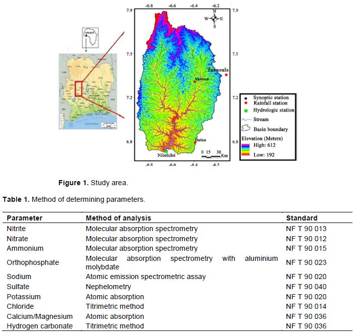
The Lobo watershed, located in the centre-west of Côte d'Ivoire, between longitudes 6° 20´ and 7° 55´ West and latitudes 6° and 6° 55´ North, is composed of three main regional departments (Daloa, Zoukougbeu and Vavoua) (Figure 1). The population size of the watershed is estimated at 1 103 059 inhabitants (INS, 2014), which corresponds to a population density of circa 165.67 inhabitants per km2. The total surface area is of approximately 7000 km2. On the investigated site, drinking water is supplied to towns and large rural communities by the SODECI water supply systems and, by home-made hydraulic water supply systems. The climate is of equatorial type of transition, characterized by a rainy season from March to October and a dry season from November to February with slight temperature changes (Yao, 2015). The geological formations of the site are dominated by three geological entities, namely the granite which occupies almost the entire basin, the schists and flysch which are found in certain places (Pothin, 1988). These geological formations are covered by essentially ferralitic and moderately desaturated soils made up of sands and clays. On the hydrogeological level, the aquifers are those of the fissured basement which are covered by an alteration level. There are two types of aquifers which are those of fissures and alterites.
To carry out this study, two sampling missions were carried out during the rainy season (September 2018) and in the dry season (February 2019). During each season, water samples were collected, stored at 4°C and analyzed in the laboratory. The material used for the acquisition of this database consists of:
(1) Polyethylene bottles of capacity (1 L) were used to take water samples and kept in coolers;
(2) A differential GPS (Leica 1200R) to record the coordinates of the various sampling points;
(3) A portable HACH LANGE HQ40D multiparameter to measure in-situ parameters represented by physics parameters which are T (°C), pH, Eh, Conductivity and DO-Dissolved Oxygen. A HACH DR 6000 type spectrophotometer for determining the contents of chemical parameters analysis at the laboratory.
Determination of physical and chemical parameters
The quality of the physical and chemical data used in this study was shown by the determination of the ion balance. The results obtained from the assayed major ion contents are less than 5% in their majority; which shows a sufficient reliability of the laboratory analytical data and consequently of the interpretations resulting from them.
The determination of chemical parameters of water is an assessment way of its quality and the biological health of the ecosystem. Laboratory tests, have been adopted the Rodier methods (2009) shown in Table 1. In the field of water resources, the tests run are those of major elements (Mg2+, Ca2+, Na+, K+, HCO3-, Cl-, NO3-, SO42-, and NH4+), nitrogen compounds (NO2-), ortho-phosphate (PO43-) and metallic trace elements (Mn2+, Zn2+ and Fe2+). The physical parameters (T (°C), pH, Eh, Conductivity and DO) were directly measured on-site. This choice of those tests was based on the different types of activities in the area as well as on the nature of the different rocks involved.
Determination of the hydro-chemical facies of the waters of the basin
The hydro-facies determination was carried out by the means of the piper diagrams software (version 6.00). When performing, the diagram compares provided groups of samples to each other and discloses the dominant types of cations and anions to find the geological origin of the reservoir. It has been used in some reported works (Ohou, 2010; Eblin et al., 2014; Mangoua et al., 2018). When applied, the diagram allows water to be grouped by their similarities in terms of proportions of cations or anions. Typically, the Piper diagram is helpful for the establishment of groundwater’s chemical facies. It is made up of two triangle shapes representing each the distribution of anions and cations, respectively, and an upper diamond shape representing the synthetic distribution of major ions. The former main diamond shape is subdivided into four elemental diamonds corresponding to a very specific type of water.
Statistical analyses of data
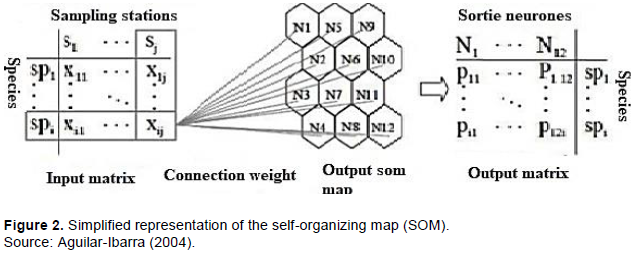
Statistical data analyses were undertaken using artificial neural networks (ANN) whose goal is to highlight the phenomena at the origin of water mineralization. For this, 19 physical-chemical parameters (T, pH, EC, O2, Eh, Mg2+, Ca2+, Na+, K+, HCO3-, Cl-, NO3-, SO42-, NO2-, PO43-, NH4+, Mn2+, Zn2+ and Fe2+) measured in well water (alterite aquifers) and borehole water (basement aquifers) constitute the input parameters of the model whose “weights” in the different samples were estimated at the output from of Kohonen's map.
The architecture of the ANN was defined to make a suitable selection of the input vector, the size of the network (or the total number of layers and neurons), the structure of the network, that is, type of interconnection between layers of neurons and transfer functions, without running after a standard procedure. Learning is performed with different map sizes and the optimal size is selected by minimizing a so-called quantization error (QE) and topography error (TE), respectively (Park et al., 2003; Konan et al., 2006).
Technically, learning relates the entry space to the map; it aims at adapting the weights (W) so that close examples in the input space are associated with the same neuron or with nearby neurons in the map. The different stages of this learning algorithm are as follows: (a) virtual objects are initialized by objects taken randomly from the data set; (b) a real object is selected randomly and presented at the input layer; (c) the distance between that selected object and each virtual object is calculated; (d) the closest virtual object is believed to be "Best Matching Unit (BMU)", then the surrounding neurons of the BMU are modified (adjustment order).
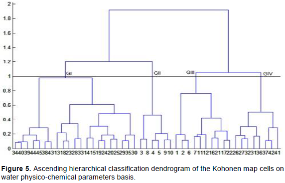
The resulted neurons from the map are grouped using an ascending hierarchical classification procedure whose grouping principle is based on Ward's criterion. It consists in grouping together as well as possible the samples having a similar behaviour on a set of variables to give a more global vision to the map (Figure 2).
Results of physico-chemical analyses of water
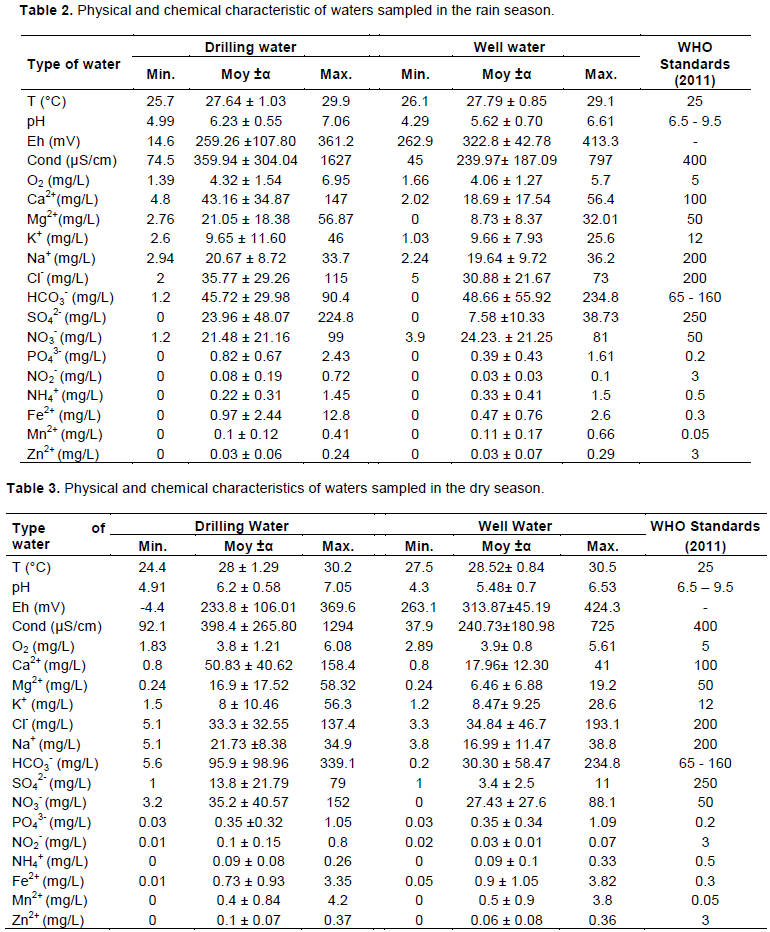
In this study, the set of parameters analyzed has been compared to existing standards. Tables 2 and 3 disclose the test results of physical-chemical parameters from the Lobo watershed. As shown, the recorded water temperature varied from 24.40 to 30.50°C for both dry and rainy seasons, respectively. For alterite sheets, the temperatures ranged between 26.10 and 29.10°C and between 27.50 and 30.50°C, respectively, for the rainy season and dry season. For both seasons an average thermal value was recorded and equals to 27.80 and 28.50°C. Also, the temperature of the cracked basement layers varies from 25.70 to 29.90°C with an average value of 27.64°C for the rainy season and from 24.40 to 30.20°C for the dry season with an average of 28.00°C (Tables 2 and 3). The mean water temperatures are the same in both types of water (above 25.00°C). For pH, the reported tests pointed out values ​​between 4.29 and 7.06 pH units, with an average of 5.62 for alterites layers against 6.23, for the cracked basement layers during the rainy season and 5, 48 for the alterite layers against 6.20 for the basement layers during the dry season (Tables 2 and 3). The average pH of the waters in the investigated area is less than 7. Overall, the pH values are those of acidic water. The electrical conductivity which reflects the level of mineralization of the water varies from one water matrix to another. However, the layers of alterites have average electrical conductivities (239.97 and 240.73 μS/cm) lower than those of the layers of cracks (359.94 and 398.4 μS/cm), respectively for the rainy and dry seasons. The waters of the region are generally characterized by a low conductivity ranging from 74.5 to 1294 μS/cm. Parameters such as NO2-, Ca2+, K+, Mg2+, Na+, NO3-, SO42-, and Cl- meet the standards set by WHO. However, concerning PO43-, the average values ​​vary from 0.39 to 0.82 mg/L for the two types of groundwater in the rainy season and are 0.35 mg/L in the dry season. These values ​​exceed the WHO potability standard of 0.20 mg/L.
Water chemical facies evaluation
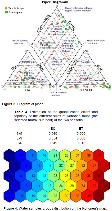
The analysis of the Piper diagram (Figure 3) relating to the chemical compositions revealed that the groundwater of the Lobo watershed is dominated by chlorinated and sulphated calco-magnesian water. They are followed by chlorinated sodi-potassium waters for alterites and hydrogen carbonate calco-magnesian for waters of the cracked rocks. In these waters, the Cl- ions constituting the most important among the anions.
Kohonen map size
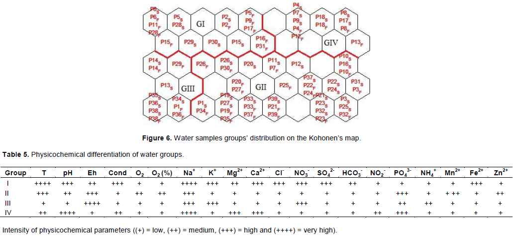
The data obtained regrouping the 19 physico-chemical parameters (T (°C), pH, Eh, EC, O2, Mg2+, Ca2+, Na+, K+, HCO3-, Cl-, NO3-, SO42-, NH4+, NO2-, NH4+, PO43- Zn2+, Fe2+, Mn2+) were analyzed using the statistical approach of Kohonen neural networks. Based on the quantization (QE) and topography errors (TE), the two minimum error types (Table 4), a Kohonen map of 45 cells (5 rows × 9 columns) is chosen to project the 80 groundwater samples from the two major seasons (30 wells and 50 boreholes) (Figure 4). This map was obtained after several iterations during the learning phase.
Ascending hierarchical classification of the Kohonen map
The dendrogram resulting from the classification made it possible to group all the groundwater samples into four groups over a Euclidean distance of 1 (Figure 5). This distance makes it possible to bring together the cells in pairs of groups having the same ancestors, therefore a strong relationship.
Distribution and count of water samples on the Kohonen map
The distribution maps, taken from the Kohonen map, make it possible to visualize the distribution of the samples of the different groups generated from the dendrograms at a Euclidean distance of 1 according to the physicochemical parameters of groundwater (Figure 6). The groups GlV appear homogeneous and are characterized by the pooling of drilling water. The other groups (GI, GII and GIII) are heterogeneous because they are made up of both samples from wells and from boreholes, the proportions of which vary from one group to another.
Differentiation and physicochemical particularities of water
Table 5 presents the importance of the physico-chemical parameters in the classification of sampling points and shows the water groups with high pollution parameters and weathering elements. Through this table, we can say that groups II and III are distinguished by high concentrations of the parameters (Na +, PO43-, Mn2+, NO3-). As for groups I and IV, they are characterized by high values ​​of the parameters (Mg2+, Ca2+, Na+, K+, HCO3-, Cl-, NO3- and SO42-, PO43-, SO42-, and Fe2+).
Lobo watershed groundwater has an average pH that varies from 5.48 to 6.20 for the two seasons. These waters are slightly acidic. This acidity could come from the decomposition of plant organic matter, with CO2 production in the surface layers of the soil under biological activities. This is the characteristic of crystalline and crystallophyllian waters media, as evaluated by Kamagaté et al. (2011) on the Bandama watershed, Tampo et al. (2014) in Togo, Alassane et al. (2015) in Benin and Heriarivony et al. (2015) in Madagascar. The waters studied have an average electrical conductivity ranging from 240.73 to 398.4 μS/cm for the two seasons. This result confers low mineralization of most of the groundwater in the study area. In agreement with Kamagaté et al. (2011), this weak mineralization is to be compared with the silicate nature of the rocky matrices crossed; the alteration and dissolution of chemical elements in ionic form are particularly slow. The average phosphate values ​​range from 0.35 to 0.82 mg.L-1. According to Matini et al. (2009), the concentration of phosphate ion in groundwater should not exceed 0.2 mg. L-1. The high levels of phosphate ions could be due not only to human actions such as the discharge of wastewater (human excreta, polyphosphates in lye) but also to the dissolution of essentially schistose crystalline rocks (metasiltstones and metaarenites) Birimian and granite formations (metagranites, granitoids and granodiorites) (Kouakou, 2018) of the study area. The Piper diagram shows that most of the fodder and wells studied have chlorinated sulphated Calco-magnesian and chlorinated sodi-potassium waters. This could be explained by the fact that the geology of the area is dominated by metamorphic rocks. Concerning the individuals of the four groups of the Kohonen’s maps, the grouping of variables composed by the majority of physicochemical parameters such as Mg2+, Na+, Ca2+, K+, Cl-, PO42-, SO42-, Fe2+, Mn2+, NH4+ and NO3- could indicate several phenomena of dissolution of ions such as oxidation-reduction reactions then contributions linked to anthropogenic activities and especially acid hydrolysis of rock minerals. The fundamental elements (Ca2+, Mg2+, Na+ and K+) present a development comparable to those observed in the regions of Bongouanou, Dimbokro, Toumodi, Bouaké and Man (Mangoua et al., 2015). These results are similar to those of Savané and Soro (2001) and Jaunat (2012) who worked respectively in the north-west of Côte d'Ivoire and on the Ursuya massif in France. The observation of these minerals in water indicates the phenomena of rock dissolution by the mechanism of acid hydrolysis of silicate minerals. The work of Lasm et al. (2011) and Mangoua et al. (2015) carried out in the regions of M’bahiakro, San Pedro and Bondoukou, respectively produced similar results.
The high contents of parameters such as Cl-, NO3-, and SO42- could also indicate the contribution of human activities in the process of water mineralization. The same observations were made in groundwater in Ghana by Yidana (2010). In fact, according to these authors, the nitrate, sodium and chloride ions contained in groundwater, supply surface horizons washed away by seepage water. The labelling of groups (I and II) by Mn2+ and Fe2+ ions shows that the mineralization of these waters is not only linked to the phenomena of hydrolysis of rock minerals and anthropogenic but also to the phenomenon of oxidation-reduction (Mangoua et al., 2015). These high levels of iron and manganese in the waters have also been observed at Yamoussoukro (Soro et al., 2019). It could also be attributed to the crystalline geological formations rich in biotite (biotite granite) in the region as reported by Ahoussi et al. (2013) in the mountainous west of Côte d'Ivoire. The high levels of iron and manganese in groundwater lead to the deficit of dissolved O2 in these aquifers by oxidation. Indeed, these two elements give water an unpleasant taste, a reddish-brown and black-brown appearance and colour. This situation forces rural populations to turn to other sources of supply whose bacteriological and parasitological qualities are questionable, which can have serious consequences on the health of populations.
The physical and chemical characteristics of groundwater from the boreholes and wells in the Lobo watershed show that the water is slightly acidic with pH values ​​between 4.29 and 7.06. Concerning the alterites layers, the average value of this pH is 5.62 against 6.23 for the basement layers cracked during the rainy season. For the dry season, the pH values are 5.48 for the layers of alterites against 6.20 for the basement layers. Overall, these waters are weakly mineralized with values varying from 239.97 to 240.73 μS/cm for the alterite sheets and from 359.94 to 398.40 μS/cm for the sheets of cracks, respectively during the rainy season and dry season. Parameters such as NO2-, Ca2+, K+, Mg2+, Na+, NO3-, SO42-, and Cl- meet the standards set by WHO. However, concerning PO43-, the average values ​​vary from 0.40 to 0.82 mg/L or the two types of groundwater in the rainy season and are 0.35 mg/L in the dry season. These values ​​exceed the WHO potability standard of 0.20 mg/L. The chemical facies of these waters are mainly chlorinated and sulphated calco-magnesian. The results of the statistical analysis show that the mineralization of water is acquired by the dissolution of the rock by acid hydrolysis and oxidation-reduction reactions. They could also come from superficial input caused by anthropogenic activities.
The authors have not declared any conflict of interests.
REFERENCES
|
Ahoussi KE, Koffi YB, Kouassi AM, Soro G, Biemi J (2013). Etude hydrochimique et microbiologique des eaux de source de l'Ouest montagneux de la Cote d'Ivoire: Cas du village de Mangouin-Yrongouin (S/P de Biankouman). Journal of Applied Biosciences 63:4703-4719.
Crossref
|
|
|
|
Alassane A, Trabelsi R, Dovonon LF, Odeloui DJ, Boukari M, Zouari K, Mama D (2015). Chemical evolution of the Continental Terminal Shallow aquifer in the South of Coastal Sedimentary basin of Benin (West-Africa) using multivariate factor analysis. Journal of Water Resource Protection 7:496-515.
Crossref
|
|
|
|
|
Awomon DF, Coulibaly M, Niamke GM, Santos DS (2018). La problématique de l'approvisionnement en eau potable et le développement des maladies à transmission hydrique dans les quartiers d'extension ORLY de la ville de DALOA (Côte d'Ivoire). Revue Espace, Territoires, Sociétés et Santé 1 (2):91-108.
|
|
|
|
|
Bendra B, Fetouani S, Sbaâ M, Gharibi E, El Halouani H, Rhomari Y (2005). Étude de l'impact de la pollution agricole diffuse sur la qualité de l'eau et du sol au niveau de la plaine de Triffa. 3ème Journées Internationales des Géosciences de l'Environnement., 1 p.
|
|
|
|
|
Dibi B (2008). Cartographie des sites potentiels d'implantation des points d'eau dans le département d'Aboisso (Sud-Est de la Côte d'Ivoire): Apport du SIG et de l'analyse multicritère. Thèse unique de Doctorat, Université de Cocody (Abidjan, Côte d'Ivoire) 164 p.
|
|
|
|
|
Djaffar S, Kettab A (2015). Simulation stratégique, politique des ressources en eau en Algérie à l'horizon 2030. Laboratoire de Recherches en Sciences de l'Eau (LRS-EAU) Ecole Nationale Polytechnique, 10 Avenue Hassen Badi, B.P. n°182, El Harrach, 16000, Alger, Algérie 1 p.
|
|
|
|
|
Eblin SG, Soro G, Sombo AP, Aka N, Kambiré O, Soro N (2014). Hydrochimie des eaux souterraines de la région d'Adiaké (Sud-Est côtier de la Côte d'Ivoire). Larhyss Journal 17: 193-214.
Crossref
|
|
|
|
|
FAO (Organisation des Nations Unies pour l'alimentation et l'agriculture) (2019). Code de conduite international sur l'utilisation et la gestion durables des engrais. Rome, 41 p.
|
|
|
|
|
Global Water Partnership (GWP) (2009). Stratégies 2009-2013 23p.
View
|
|
|
|
|
Heriarivony SC, Razanamparany B, Rakotomalala JE (2015). Caractères physicochimiques et bactériologiques de l'eau de consommation (puits) de la commune rurale d'Antanifotsy, région Vakinankaratra, Madagascar. Larhyss Journal 24:7-17.
|
|
|
|
|
INS (2014). Recensement énéral des populations et des habitats. Répertoire des localités: Région du Haut-Sassandra. Rapport d'activités 42 p.
|
|
|
|
|
Jaunat J (2012). Caractérisation des écoulements souterrains en milieu fissuré par approche couplée hydrologie géochimie-hydrodynamisme Application au massif de l'Ursuya (Pays Basque, France). Thèse de Doctorat, Université Michel de Montaigne Bordeaux 3:121-184.
|
|
|
|
|
Kamagaté B, Goné DL, Doumouya I, Ouattara I, Ouedraogo M, Bamba A, Savané I (2011). Relation nappe-rivière dans le bassin versant du Bandama en milieu de socle fissuré en Côte d'Ivoire: approche couplée hydrochimie-télédection. International Journal of Biological and Chemical Sciences 5 (1): 206-216.
Crossref
|
|
|
|
|
Konan KF, Leprieur F, Ouattara A, Brosse S, Grenouillet G, Gourene G, Winterton P, Lek S (2006). Spatio-temporal patterns of fish assemblages in coastal 161 West African rivers: a Self-Organizing Map approach. Aquatic Living Resources 19:361-370.
Crossref
|
|
|
|
|
Kouadio JOK, Dibi B, Mangoua MJ, Eblin SG, Konan DE, Graillot D (2019). Evaluation de la productivité des aquifères fissurés du bassin versant de la Lobo (Centre-ouest de la Côte d'Ivoire). Journal International Sciences et Technique de l'Eau et de l'Environnement 4(1):381-389.
|
|
|
|
|
Kouakou AB (2018). Variabilité climatique, activités anthropiques et réponses hydrologiques du bassin versant de l'Agneby à Agboville (Côte d'Ivoire) Thèse Unique de Doctorat, Université Nangui Abrogoua (Abidjan, Côte d'Ivoire) 191 p.
|
|
|
|
|
Labe S, Jourda P, Saley MB, Youan TM, Lasm T, Kouadio BH (2018). Apport de la télédétectionet des SIG dans la cartographie des zones
|
|
|
|
|
favorables à l'implantation de forages d'eau à gros débits dans la région de Daloa. Journal International Sciences et Technique de l'Eau et de l'Environnement 3(1):38-42.
|
|
|
|
|
Lasm T, Lasme O, Oga MS, Youan Ta M, Baka D, Kouamé KF, Yao KT (2011). Caractérisation hydrochimique des aquifères fissurés de la région de San-Pédro Sud-Ouest de la Côte d'Ivoire. International Journal of Biological and Chemical Sciences 2:642-662.
Crossref
|
|
|
|
|
Mangoua MJ, Gone DL, Kouassi KA, N'guettia KG, Douagui GA, Savane I, Biemi J (2015). Hydrogeochemical assessment of groundwater quality in the Baya watershed (Eastern of Côte d'Ivoire). African Journal of Agricultural Research 10(49):4477-4489.
Crossref
|
|
|
|
|
Mangoua MJ, Konan kS, Kouame kI, Zougrou, NN, Kouassi kL, Savane I, Biemi J (2018). Evaluation de la vulnérabilité à la pollution des eaux souterraines du département de Tiassalé (Sud de la Côte d'Ivoire). EWASH & TI Journal 2(2):46-54.
|
|
|
|
|
Matini L, Moutou JM, Kongo-Mantono MS (2009). Evaluation hydro-chimique des eaux souterraines, en milieu urbain au Sud-Ouest de Brazzaville, Congo. Afrique science 5(1):82-98.
Crossref
|
|
|
|
|
Mourey V, Vernoux JF (2000). Les risques pesant sur les nappes d'eau souterraine d'Ile-de-France. Annales des mines pp. 32-40.
|
|
|
|
|
Ohou MJA (2010). Impacts des activités anthropiques sur la qualité physico-chimique des ressources en eau souterraine du bassin versant de la Lobo (Buyo, Sud-Ouest de la Côte d'Ivoire): Cas du nitrate. Thèse de Doctorat, UFR des Sciences et Gestion de l'Environnement, Université d'Abobo-Adjamé (Abidjan, Côte d'Ivoire) 118 p.
|
|
|
|
|
Park YS, Chang J, Lek S, Cao W, Brosse S (2003). Conservation strategies for endemic fish threatened by the three Gorges Dam. Conservation Biology 17:1748-1758.
Crossref
|
|
|
|
|
Pothin K (1988). Pétrographie et géochimie des formations précambriennes de la région d'Odienné (Nord-Ouest de la Côte d'Ivoire). Thèse Doctorat d'Etat Université Nationale de Côte d'Ivoire 180 p.
|
|
|
|
|
Savané I, Soro N (2001). Caractérisation chimique et isotopique des eaux souterraines du Nord-Ouest de la Côte: recharge des aquifères discontinus de la région d'Odienné. Africa Géoscience Review 8(3/4):379-390.
|
|
|
|
|
Soro G, Soro TD, Fossou NMR, Adjiri OA, Soro N (2019). Application des méthodes statistiques multivariées à l'étude hydrochimique des eaux souterraines de la région des lacs (Centre de la Côte d'Ivoire). International Journal of Biological and Chemical Sciences 13(3):1870-1889.
Crossref
|
|
|
|
|
Tampo L, Ayah M, Kodom T, Tchakala I, Boguido P, Bawa L, Djaneye B (2014). Impact de la demande en chlore et de la chloration sur la désinfection des eaux de puits des quartiers de Lomé: Cas des quartiers de Démakpoé et d'Agbalépédogan (Togo). Journal Applied Bioscience 75:6272-6281.
Crossref
|
|
|
|
|
WHO, UNICEF (2017). Safely managed drinking water: thematic report on drinking water 2017 52p.
View
|
|
|
|
|
Yao AB, Goula BTA, Kane A, Mangoua OMJ, Kouassi KA (2016) Cartographie du potentiel en eau souterraine du bassin versant de la Lobo (Centre-Ouest, Côte d'Ivoire) : approche par analyse multicritère, Hydrological Sciences Journal 61(5):856-867.
Crossref
|
|
|
|
|
Yao AB (2015). Evaluation des potentialités en eau du bassin versant de la lobo en vue d'une gestion rationnelle (Centre-Ouest de la Côte d'Ivoire). Thèse Unique de Doctorat, Université Nangui Abrogoua (Abidjan, Côte d'Ivoire) 193 p.
|
|
|
|
|
Yidana SM (2010). Groundwater classification using multivariate statistical methods: Southern Ghana. Journal of African Earth Sciences 57:455-469.
Crossref
|
|