The paper dealt with increased streamflow dynamics and implications for flooding in the Lower River Benue Basin. The study utilised data collected over a period of more than fifty years (1955-2012) from three hydrological stations operated by the Nigerian Hydrological Services Agency (NIHSA). The average discharge at Umaisha was 4,919.47 cubic metres per second (m3/s). Average discharge at Makurdi hydrological station was 3,468.24 m3/s. The monthly average discharge for Katsina Ala did not record any amount over 2000 m3/s in any month of year from 1955-2012. The rating curves for Umaisha and Makurdi showed a smooth streamflow with Umaisha surpassing the average discharge at 661 cm. Makurdi surpassed the average streamflow of the station at 654 cm. River Katsina Ala rating curve showed a rough streamflow. The trend of discharge rate for the three hydrological stations showed a rise over the years assessed and staggering discharge rates were recorded during peak periods in some years. Evidence provided show increasing streamflow variability and flood risk due to rainfall intensity and release of excess dam water from Lagdo dam in Cameroun. In order to prevent and control flood damage, useful recommendations have been proffered.
It is important to assess drainage systems to embark on effective water management which has become quite significant in the light of climate change evidence in literature. Understanding streamflow dynamics is important if related challenges such as droughts and floods are to be managed adequately. It has been stated in literature that streamflow monitoring received increased attention in the 1970s in Nigeria. However, many flow monitoring stations are faced with faulty equipment while some have been abandoned (Akpoborie et al., 2012).
Nigeria is endowed with numerous rivers and streams. The biggest water bodies with vast flood plains are the rivers Niger and Benue. Most of the major floods which occur annually in Nigeria occur within the floodplains of the rivers Niger and Benue and their numerous tributaries. Despite the importance of streamflow dynamics in the major flood plains in Nigeria, the subject has received little attention in literature unlike other parts of the world (Akpoborie et al., 2012; Nwilo et al., 2012; Adelalu, 2012; Ehiorobo et al., 2013). It has therefore become essential to assess streamflow dynamics in river basins around the world including the Lower River Benue Basin in Nigeria given the risk of increased flooding globally due to global warming. This study therefore aims to assess the level of increased streamflow in the lower River Benue basin in order to further highlight the risk of flood increase.
Study area
The area of study is located between Latitudes 7° 13’N and 8°00’N and Longitudes 8°00’E and 9°00’E within the Lower River Benue Basin. Most parts of the study area fall within the boundaries of Benue State. According to Ayoade (2004) and Climate-data (2015), the climate of Makurdi and Katsina Ala and Otukpo which are located within the Lower River Benue Basin are the tropical wet and dry type, according to Koppen’s Aw classification, with double maxima. The rainy season usually lasts from April to October with an average annual rainfall of 1,332 mm (Makurdi), 1,547 mm (Katsina Ala), and 1496 mm (Otukpo).
The land is generally low lying (averaging 100 to 250 m) and a gently undulating landscape (Kogbe, 1989). The River Benue is the dominant geographical feature in the state. River Benue rises from the Adamawa Plateau of Central Cameroon, then flows west across Central Nigeria, and joins River Niger as the main drainage feature in the area. It is one of the few large rivers in Nigeria. The Katsina-Ala is the largest tributary of the River Benue, while smaller rivers include Mkomon, Amile, Kpa, Okpokwu, Duru, Loko Konshisha, Ombi Mu, Be, Apa Ogede and Aya. The flood plains of the River Benue are characterized by extensive swamps and ponds which have potential for dry season irrigated farming. Though Benue State has high drainage density, many of the streams are seasonal.
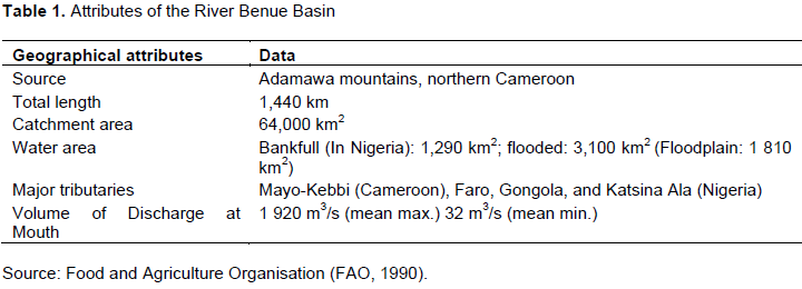
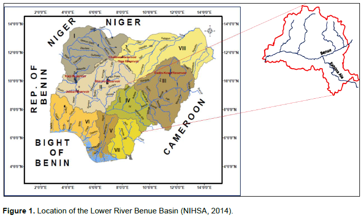
The largest water body in the Lower River Benue Basin is the River Benue which meets with the River Niger about 483 km from the coast at a confluence point in Lokoja, Kogi State. The width of the River Benue varies from about 488 to 976 m. It is navigable during the wet season from May to September for a length of more than 965 km (Uchua and Ndukwe, 2011). The River Benue is about 1,440km long with a surface area of 129,000 ha. The floodplain of the River Benue Basin is about 181,000 ha making it an important economic resource for the region (Ita et al., 1985). Table 1 provides more information on the River Benue Basin while Figure 1 shows the location of the Lower River Benue Basin.
Many tribes inhabit the Lower River Benue Basin. These tribes include Tiv, Idoma, Etilo, Jukun, Egede, Hausa, Yoruba and Ibo with the Tivs being dominant. The main livelihood activity is subsistence agriculture. Other occupations include the civil service, commerce and manufacturing industries. Subsistence agriculture is practiced extensively at the periphery, including some open lands within major towns. Irrigation gardening, sand harvesting and burnt bricks production are carried out along the banks of the River Benue. Local fishing is another important economic activity on the River Benue. Makurdi town has a few medium scale industries such as a plastics factory and a fertilizer blending plant. It has an airport, a soft drink bottling company, a brewery, and fruit concentrate company. Commercial activities include the many markets and grain milling plants.
The physiography of the Lower River Benue Basin was determined from satellite imagery of the area using ArcGIS software. The survey provided a basis for identifying the sources of surface-water. The paper utilised data collected over a period of more than fifty years (1955-2012) from three hydrological stations (Umaisha, Makurdi, and Katsina Ala) operated by the Nigerian Hydrological Services Agency (NIHSA). The data for Umaisha hydrological station was from 1980 when the equipment was commissioned by NIHSA. Some years witnessed days of incomplete data due to faulty equipment. The River Benue discharge rate was analysed from hydrologic data. The hydrological parameters of particular interest were discharge rate and rating curve, water level, drainage networks, flood peaks, and damming potentials.
In order to present the contribution of rainfall to flood risk and increased streamflow dynamics, 40 years rainfall data on Makurdi from 1973 to 2013 was sourced from the Nigerian Metrological Agency Abuja and analysed for intensity, trends and variation. Analysis of data was carried out in Microsoft Excel and the Statistical Package for Social Sciences (Version 17). Flood risk simulation data was sourced from the annual flood outlook report in Nigeria which is prepared by NIHSA using Geospatial Stream Flow Model (GeoSFM) and Soil and Water Assessment Tool (SWAT) modelling software.
Rainfall characteristics
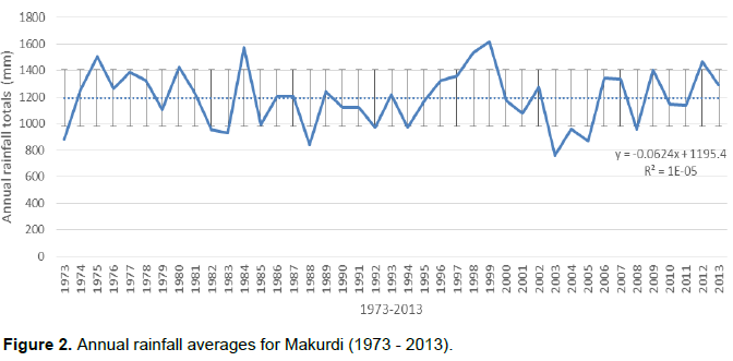
The average daily rainfall for the period 1973-2013 was 133.8 mm with a median of 108.7 mm. The highest value for daily rainfall recorded was 149 mm on the 3rd of August 2000. The annual rainfall average recorded for the period 1973-2013 was 1194.1mm with a median of 1207.9 mm. The highest amount was recorded in 1999 (1617.1 mm). The year with the lowest amount of rainfall was 2003 (761.5 mm). The annual rainfall totals for Makurdi is presented in Figure 2.
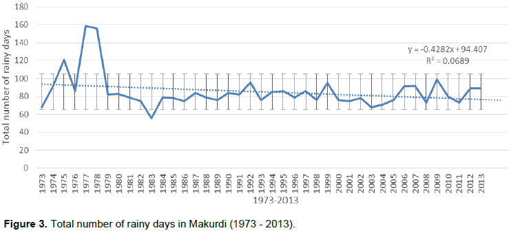
The number of rainy days from 1973 to 2013 averaged 85.7 days. The annual rainy days from 1973 to 2013 is presented in Figure 3. The year with the highest number of rainy days was recorded in 1977 (159 days). The lowest number of rainy days was recorded in 1983 (56 days). The number of total annual rainy days is decreasing.
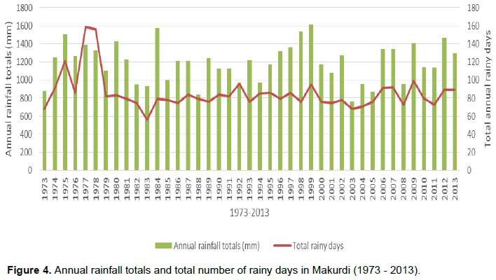
The relationship between total number of rainy days and annual rainfall totals is presented in Figure 4. Figure 4 shows that the year 1977 which had the highest number of rainy days had produced an annual rainfall total of 1387.1 mm. The year 1978 which had a total number of 156 rainy days produced an annual rainfall total of 1326.2 mm, and 56 rainy days in 1983 produced an annual total of 930.3 mm.
Even though the number of rainy days seems to be decreasing, the annual rainfall totals is not decreasing. There are several years in which less than a hundred days of rainfall produced annual rainfall totals over 1200 mm which is above the annual average of 1194.1 mm from 1973 to 2013. The year 2012 which was most recently notable for rainfall intensity and severe flooding, recorded a total of 1407 mm of rain in 89 days.
Drainage discharge rate
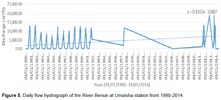
The instantaneous daily discharge data (1955 to 2014) was collected from three hydrological stations in the Lower River Benue Basin that were readily available. The stations are Umaisha (1980-2014), Makurdi (1955-2014), and river Katsina Ala (1955-2012). The Umaisha hydrological station is located close to the confluence of the River Benue and River Niger, while the others are located in Makurdi and Katsina Ala L.G.As. Although the entire data collected was for the period of January 1955 to May 2014, a few omissions exist due to faulty measuring equipment and the more recently commissioned Umaisha hydrological station.
The average discharge at Umaisha from January 1980 to May 2014 was 4,919.47 m3/s. The maximum discharge for the period was 19,120 m3/s which was recorded on the 15/10/2012. The line chart in Figure 5 shows the discharge amounts at Umaisha from 01/01/1980 to 31/05/2014. The linear forecast trend line shows the trend of discharge is gradually rising.
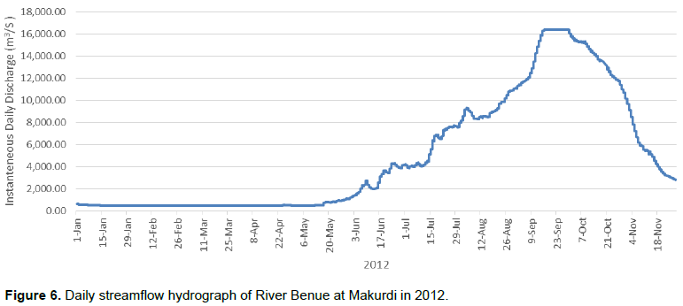
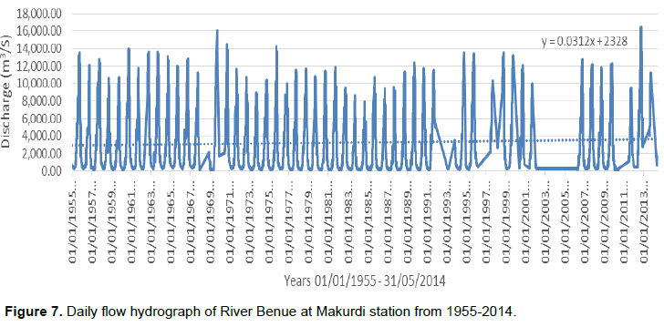
Average discharge at Makurdi hydrological station was 3,468.24 m3/s. The peak flow discharge of 16,400 m3/s was recorded in three days 19th, 29th, and 30th in the month of September 2012 while the peak flow of 2011 was 9,436 m3/s. The average flow derived for Makurdi which was 3,468.24 m3/s was surpassed in June. Figure 6 shows the instantaneous daily discharge of the River Benue for the 2012.
The lowest discharge rate in the River Benue was recorded in 1983 while the highest discharge rate occurred in 2012. The total flow in 2012 was not equalled between 1961 and 2011 (50 years). The second highest discharge rate of 15,975 m3/s was recorded in September 1969. There was high inflow during the month of June before the arrival of peak flow periods of July and September from Upper Benue Basin. The high inflow in July, August and September 2012 led to River Benue overflowing its banks and submerging land areas and settlement in Upper and Lower Benue Basins. In addition, there was a high discharge into River Benue from Lagdo Reservoir in Cameroun in July and subsequent months. Thus, high flow in River Benue is due to both inflow from Lagdo dam in Cameroun and inflows from the Upper and Lower Benue Basins. Figure 7 shows the discharge amounts at Makurdi hydrological station from 01/01/1955 to 31/05/2014. The linear forecast trend shows a gradual rise over the years.
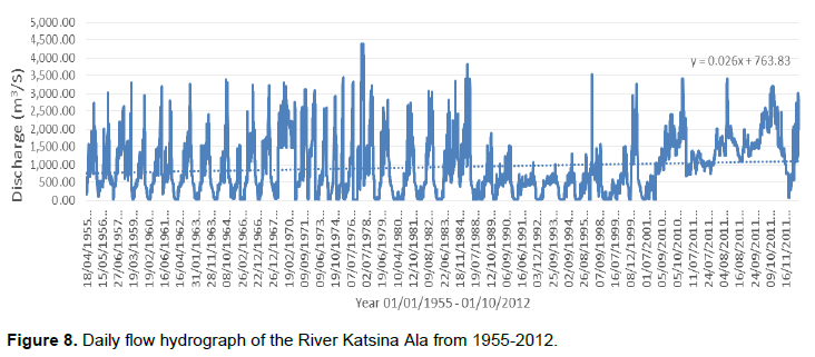
At River Katsina Ala hydrological station, the average discharge from January 1955 to May 2014 was 933.12 m3/s. The maximum discharge for the period was 4,401 m3/s which was recorded on the 20/10/1977. The line chart in Figure 8 shows the discharge amounts at River Katsina Ala from 01/01/1955 to 01/10/2012. The linear forecast trend shows a gradual rise in discharge.
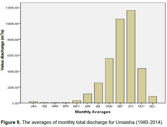
The averages of monthly total discharge for the period 1980 to 2014 for Umaisha hydrological station (Figure 9) reveals that the River Benue recorded the highest discharge amounts in the months of September (10,556.95 m3/s) and October (11,651.88 m3/s). The months of July to November recorded significant discharge amounts from 1980 to 2014 at Umaisha.
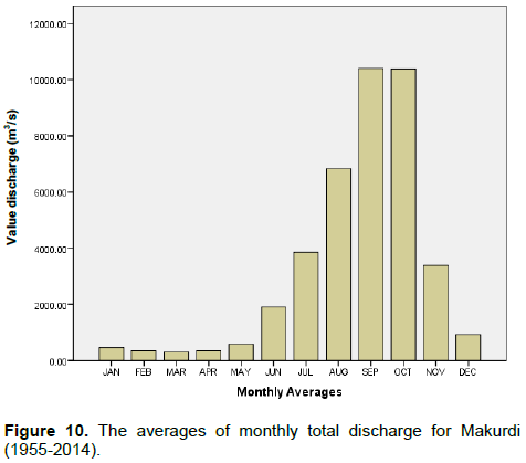
The average monthly total discharge for Makurdi was quite similar to Umaisha. In addition to the high discharge amount in September (10,390.17 m3/s) and October (10,370 m3/s), amounts over 2000 m3/s was recorded between July and November (Figure 10). However, unlike Umaisha, the highest monthly average discharge amount in Makurdi was September.
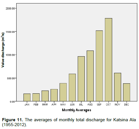
The monthly average discharge for Katsina Ala hydrological station (Figure 11) is not entirely similar to that of Makurdi and Umaisha. The station did not record any discharge amount over 2000 m3/s in any month of year from 1955 to 2012. The months of September (1518.76 m3/s) and October (1781.85 m3/s) recorded the highest monthly average discharge amounts. The lower amounts from Katsina Ala are understandable because it is a smaller river and a tributary of River Benue.
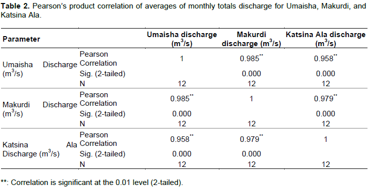
All the averages of monthly totals of the three hydrological stations where correlated to test if a significant relationship existed between them. The result is presented in Table 2. The monthly discharge averages for Umaisha, Makurdi and Katsina Ala correlated positively with significant values (p< 0.01).
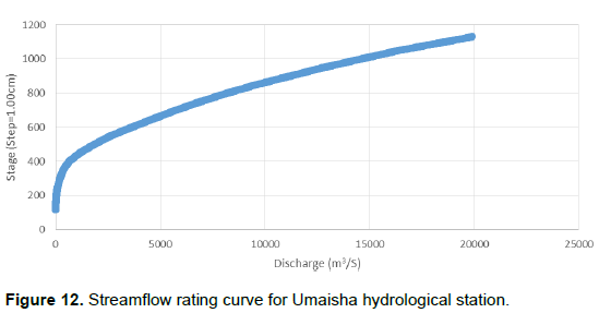
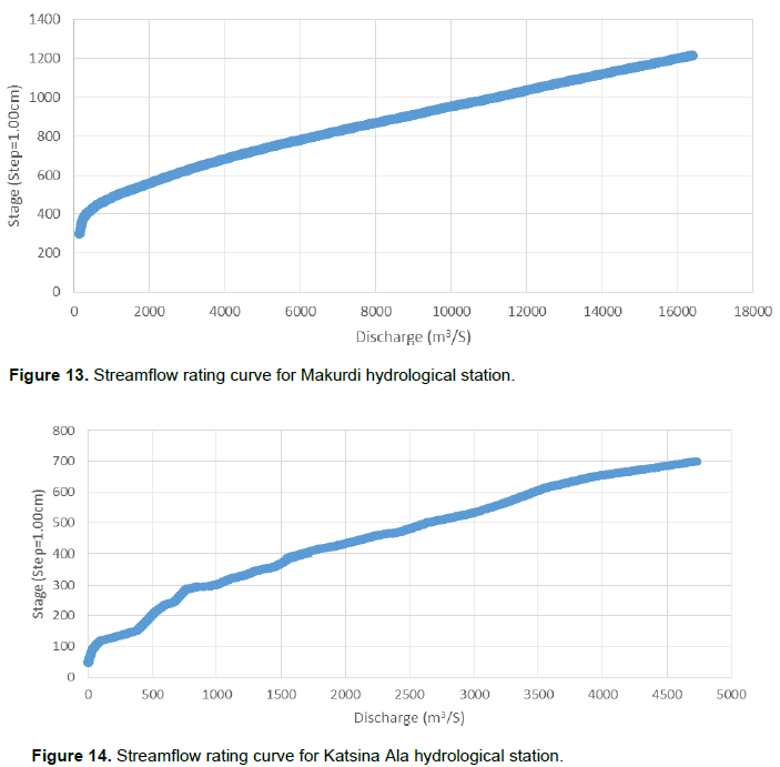
The rating curve for the Umaisha, Makurdi, and Katsina Ala were produced (Figures 12 and 13). The rating curves for Umaisha and Makurdi showed a smooth streamflow with Umaisha surpassing the average discharge at 661 cm (Figure 12). Makurdi surpassed the average streamflow of the station at 654 cm (Figure 13). River Katsina Ala rating curve showed a rough streamflow. The River Katsina Ala has several rapids and this may have reflected in the rating curve of the hydrological station. The streamflow of River Katsina Ala surpassed average discharge rate at 297 cm (Figure 14).
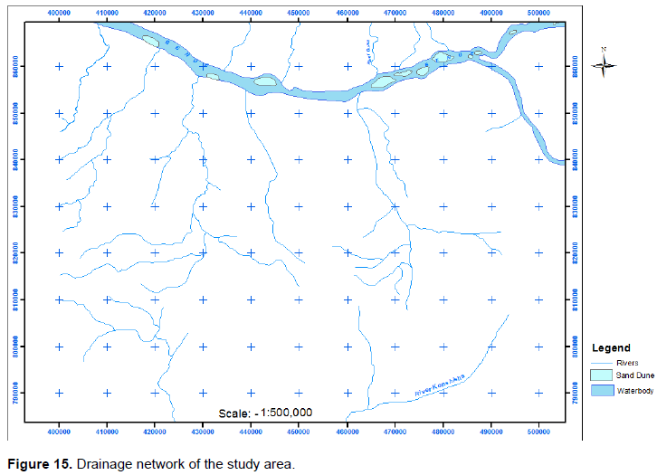
The drainage map which shows the stream networks of the study area is presented as Figure 15. A total of eleven streams which include River Katsina Ala and River Guma where identified. All these streams are viable throughout the year and provide potential opportunities for local dams and irrigation farming across the study area. There is currently no modern constructed dam in the Lower River Benue Basin.
Increased flood risk in the Lower River Benue Basin
The Nigeria Hydrological Services Agency (NIHSA), in accordance with its statutory mandate to issue flood forecasts, monitors the trend of floods in Nigeria annually. NIHSA releases an annual flood outlook report which provides information to prepare Nigerians living in flood risk areas to be at alert in the event of floods which could damage property and human life.
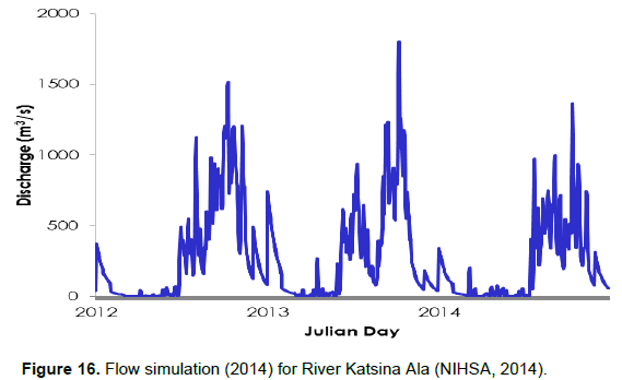
According to NIHSA (2014), the flow simulation for River Katsina Ala hydrological station for 2014 produced a Julian discharge of 1,368.78 m3/s. The Julian day for 2013 (1,801.86 m3/s) was higher than that of 2012 (1,515.46 m3/s) for Katsina Ala station (Figure 16).
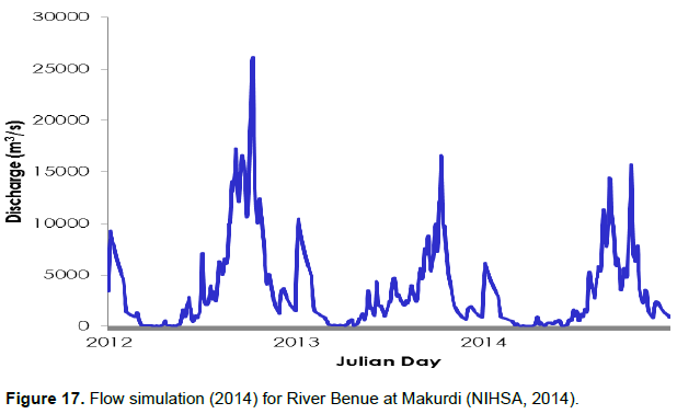
The 2012 Julian day discharge rate for Makurdi was 26, 088.72 m3/s. This was not reflected earlier in the daily streamflow hydrograph for Makurdi as it was obtained from another report and no date was given for the Julian day by NIHSA (2014). The Julian day for 2013 for Makurdi hydrological station was 16,435.65 m3/s while the 2014 prediction put the Julian discharge at 15,732.45 m3/s (Figure 17).
The flood plains in the Lower River Benue Basin have been very beneficial to agriculture and this has given rise to high density settlements along the River Benue and its major tributaries such as Umaisha, Makurdi, Tarka, and Katsina Ala (Akpan-Idiok et al., 2013). The occurrence of several streams in a basin provides challenges and opportunities as well as tremendous societal significance especially in surface hydrology (Cuo et al., 2014). One of such challenges is the fluctuation in stream volume which overflows during peak seasons. The resulting floods have potential to cause fatalities and huge damage to assets and farms. The gradual rise in discharge rate, and increased fluctuation of streamflow in the Lower River Benue Basin has been mentioned elsewhere (Adelalu, 2012). These phenomena can be explained by rainfall intensity from the rainfall data presented and release of upstream dam waters from the Lagdo dam in northern Cameroun. The influence of the Lagdo dam on flooding on the River Benue is well documented in literature and in local and online media. The causes of flooding in the Lower River Benue Basin has been discussed in Ologunorisa and Tor (2006), Abah (2012), and Ojigi et al. (2013). The profound changes on the hydrological environment around the world have been attributed to climate change (Ehiorobo et al., 2013). The impact of changing climate on streamflow is receiving attention from scholars globally. Aich et al. (2014) studied impact of climate in four African river systems and found a tendency for increased streamflow in three of the four basins. Aich et al. (2014) called for increased attention to river systems in Africa due to risk of increasing high flows. Therefore, rainfall intensity due to changing climate has a significant impact on the streamflow results presented.
Urban growth and development due to land use changes can also influence streamflow. According to Tyubee and Anyadike (2012), a decrease of 19% (4 km2) occurred in the area of water in Makurdi the Benue State capital from 1991(21 km2) to 2006 (17 km2). Forest areas witnessed a decline by 28% (37 km2) for the same period from 1991(133 km2) to 2006 (96 km2). Undergrowth and wetland areas decreased by 32% (119 km2) between 1991 (370 km2) and 2006 (251 km2). Similarly, cultivated areas shrunk by 14% (19 km2) from 1991 (138 km2) to 2006 (119 km2) in 2006. All these changes in land use were attributed to urban growth and development by Tyubee and Anyadike (2012), as built-up areas witnessed an increase of 130% (179 km2) from 1991 (138 km2) to 2006 (317 km2). Tyubee and Anyadike (2012) stated that degradation of wetlands, water channels and deforestation due to increased urban population and unregulated land use contributes to flooding. Increased built-up areas have the potential to increase run-off after intensive rainfall.
A severe flooding event occurred in Nigeria in 2012 as intensive rainfall and river overflow caused extensive flooding in the flood plains of the River Benue and River Niger. The flooding of 2012 was escalated by the discharge of floodwaters from the Lagdo dam in Cameroon into the River Benue. Obiora (2014) conducted a study on 120 farmers in Benue State to assess the impact of the 2012 floods on these farmers. According to Obiora (2014), these farmers lost houses and storages (60.0%), farmlands (60.0%), and human lives (10.0%). In order to survive the losses from the floods, 35.0% of the respondents resorted to begging alms and another 30.0% migrated to neighbouring communities. Obiora (2014) stated that 70% of respondents had no survival strategies and resigned to fate. A total of 112, 362 people were internally displaced by the 2012 floods and a total area of 932.46 km2 was inundated by the 2012 floods (Ojigi et al., 2013). The annual occurrence of flooding in the study area is adequately reported in literature (Ologunorisa and Tor, 2006; Abah, 2012; Ojigi, 2013; Shabu and Tyonum, 2013). In order to control flood damage in the study area, the government of Benue State should explore these modern measures:
1. Development of dams and reservoirs which are currently lacking.
2. Improved streamflow prediction and flood warning mechanisms
3. Clearing debris from water channels and drainages for river and rainfall run-offs.
4. Re-dredging of silted streams and construction of new drainages.
5. Mid-term and long-term plans to relocate people living along river banks and those that have livelihood activities on the flood plains of the Lower River Benue Basin.