Full Length Research Paper

ABSTRACT
The study was carried out to understand the risks posed by earthquakes in Karonga based on roles and perception of stakeholders. Information was collected from several stakeholders who were found responding to earthquakes impacts in Karonga Town. The study found that several stakeholders, governmental and non-governmental department and organisation operate in Karonga District to respond to hazards and disasters that occur in the district however most of these stakeholders concentrate their activities in rural areas than the town despite having the town experiencing greater impacts from earthquake hazards. The study also found that people of Karonga are aware of earthquakes and how they can avoid their impacts however their economic status fail them from developing infrastructure that can help them to avoid or recover quickly from the impacts of earthquake disasters. It is therefore concluded that the people of Karonga town are vulnerable to earthquake hazards due to limited capacity to develop appropriate infrastructure that can survive seismic hazards.
Key words: Earthquake, seismic, risk, vulnerability, capacity.
INTRODUCTION
Earthquakes are ground motions resulting from the abrupt release of strain energy in the rock that builds up over a period of time (De Blij and Mullar, 1996; Biggs et al., 2010). The majority of earthquakes are caused by the abrupt movement of the ground along fault planes within the interior of the earth crust (Alexander, 2001). The rocks in the subsurface environments disintegrate under the strain and the rocks on both sides of the fault rebound to their initial positions (Biggs et al., 2010) and this elastic rebound is the basic cause of the earthquake shock waves. Seismology is the science of elastic or seismic waves that deals with origin and propagation of earthquake’s shock waves across and through the earth (Alexander, 2001; Biggs et al., 2009a, b). Ammon (2010) noted that ‘seismic waves or earth tremors are a function of the wavelength. The frequency the period (and the amplitude).’ The irregularities of the peaks and troughs even under uniform frequencies called phase shift some-times phase difference are an important characteristic of the seismic waves (Alexander, 2001).
The East African Rift System (EARS) has been experiencing earthquake hazards resulting from these seismic activities and a lot have been recorded in the past decades. The active seismicity along the EARS is a result of the movement along its fault margins. Skinner (2003) argues that ‘There is no evidence that seismic hazards are occurring more recently than before despite their increasing lethal effects.’ If the allegation that the environment is not being subjected to new seismic risk is correct, it follows that human beings are making investments in potentially hazardous areas to tremors and seismic risks (Skinner, 2003). This could be the reason why the development of Karonga Town could have predisposed the people to such a risk. According to Skinner (2003) “Among the factors subjecting populations to seismic risk include population growth, urbanization, pressure to develop marginal lands, economic growth creating more built environment that are prone to damage and increasing inability of government to cope with even small scale events that previously occurred thus an increase in reported disasters is in part due to the development of communication and mass media coverage such that we hear more of these earthquake events than before”.
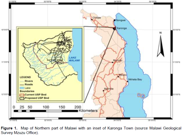
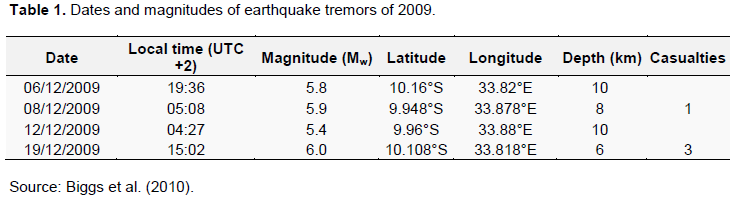
People in poor communities including those living in towns are more vulnerable than in more economically developed communities (Skinner, 2003; Adelekan et al., 2015). Wisner et al. (2004) noted that one of the major reasons why people in less economically developed communities are more affected by seismic hazards is lack of access to resources that can be used to prevent the disastrous conditions which result from the hazards and also due to lack of resources to completely recover from previous occurred hazards. Skinner (2003) also notes that while people in less economically developed countries will lose less they still suffer a lot because of lack of access to resources and on the other hand people in more developed countries will lose more because them have a lot exposed to hazards however more economically developed communities will quickly retain normal life after the disaster (Wisner et al., 2004). Karonga is located at the northern tip of the Malawi Rift System (Figure 1). Seismic data indicate Karonga and northern Malawi are the most seismically active areas in the country mostly experiencing low-to-moderate earthquakes with the December 19, 2009 (M=6.0) earthquake being the most damaging one in recent years (Figure 2). The December 19, 2009 (M=6.0) had its epicenter ~20 km south west of Karonga Boma at longitude 33.811 and latitude -10.11.
The occurrence of earth tremors are not a new phenomenon in Karonga town (Macheyeki et al., 2014). The tectonic activities are typical of Karonga town since the town lies on a fault line parallel to the Livingstone fault which forms Lake Malawi (Geological Survey of Malawi, 1966; Biggs et al., 2010). The occurrence of earth tremors can arguably be traced back to tectonic processes which formed the lake as far back as one million years ago (Geological Survey of Malawi, 1966). Reports indicate that the vulnerability of the town to earthquakes dates back from the times of the Town’s historical development (Macheyeki et al., 2014).
Nevertheless, there remains lack of data on the risks posed by the earthquakes as well as vulnerability and capacity of the authorities and communities to deal with the risks in Karonga Town.
Objectives of the study
Main objective of the study
The main objective of the study was to understand the risks caused by earthquakes and existing capacity in Karonga Town.
Specific objectives
This study sought to:
1. Determine the nature, scale, extent and distribution of seismic/earthquake risks in Karonga Town.
2. Identify institutional arrangements in seismic risk interventions and their activities in Karonga Town.
LITERATURE REVIEW
Overview of the occurrence of earthquakes
As earthquakes occur they generate seismic waves or pulses of energy that can pass through the whole earth (de Blij and Muller, 1996). Geographically earthquakes are more prevalent in areas with tectonic activities such as conservative, destructive and constructive margins (Biggs et al., 2009).
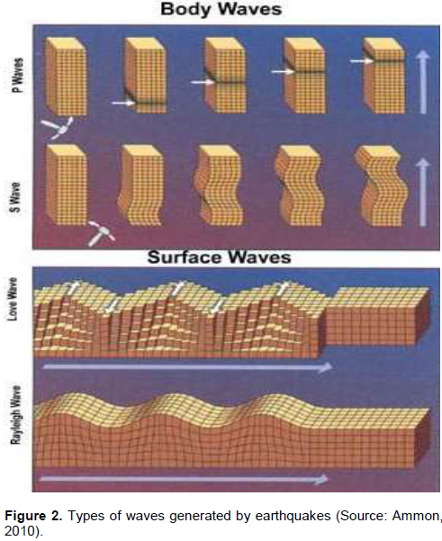
An earthquake generates different kinds of waves each characterized by its speed and direction (Ammon, 2010). A seismic wave is an elastic wave generated by an impulse such as an earthquake or an explosion. Seismic waves may travel either along or near the earth's surface (Rayleigh and Love waves) or through the earth's interior (P and S waves) (Alexander, 2001) (Figure 1). Waves that emanate from the site of the quake inside the earth are called body waves (Ammon, 2010) (Figure 2).
The first of these are known as P waves, for primary or pressure. They are fast, traveling through rock at over 225 miles per hour (360 km/h) and through water at about one-third that speed, pushing, pulling, and compressing the earth in the direction of their travel. An earthquake also causes secondary or shear waves called S waves (Biggs et al., 2010; Ammon, 2010). These travel at about half the speed of P waves, but can be much more destructive. S waves move perpendicularly to the direction the wave is traveling. Rayleigh waves churn over and under like rolling ocean waves; Love waves shake the earth from side to side. Love and Rayleigh waves, are the ones often responsible for making buildings collapse (Ammon, 2010). The point of fracture in known as the focus of the earthquake and the point vertically above the focus on the surface of the earth is known as the epicenter (De Blij and Mullar, 1996).
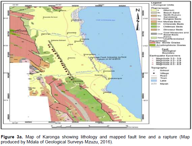
Karonga Town is located on an irregular basin which lies on the fault line that forms part of the Livingstone fault (Biggs et al., 2010). Karonga Town is susceptible to seismic waves which are a result of the tectonic activities associated with the great east African rift valley fault, a constructive margin, which forms the Lake Malawi. A number of seismic risks are expected in Karonga Town. Flannery and Rosendahl (1990), Ebinger et al. (1999) indicate that the loading of sediments on the fault deepens to 6 km such a situation is recipe to requefaction especially with raised water table as most of the deposit form good aquifers. Flannery and Rosendahl (1990) suggest the existence of parallel faults which result in reflection of seismic waves during tremors. In contrast to the steep eastern boundary, the western shore comprises a 5 to 10 km wide coastal plain covered by Quaternary sediments (Figure 3a) (Burke and Gunnell, 2008). Further west, hilly topography composed of Precambrian bedrock rises along the E-dipping Karonga Fault (Biggs et al., 2010). Karonga Town experienced a disaster which was triggered by and earthquake in 2009.

Geology of Karonga district
The greater part of Malawi is underlain by crystalline Basement Complex rocks of Precambrian to Palaeozoic age, mostly consisting of gneisses and granites (Figure 3a). These rocks form what is broadly called “The Malawi Basement Complex”. In some localities, the Basement Complex rocks are overlain by Karroo System rocks (Carter and Bennet, 1973). Most of the Basement Complex rocks have undergone medium to high grade metamorphism and a prolonged structural and metamorphic history that was dominated by orogenic movements, faulting, rifting and formation of the Malawi Rift Valley (Carter and Bennet, 1973).
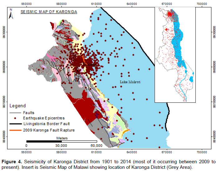
The western part of Karonga is mostly characterized by hard rock formations (Basement Complex Rocks), around the town and the eastern side of the district; superficial deposits dominate mostly alluvium (Figure 3a). Structurally, the area is mostly defined by NW - SE major faults which dominate the Basement Complex rocks to the western side of Karonga town. To the eastern part of the study area lies Lake Malawi which is characterized by normal faulting patterns with an orientation of NW - SE, its major faults (border faults) that defines the lake are the Livingstone Border Fault to the eastern part of the lake (Figure 3b). To the far western side of the town lies the Karonga fault which has a similar orientation to the Livingstone fault. These two faults, that is, Livingstone to the east and Karonga to the west defines the Karonga Basin which is seismically active.
Seismicity of Malawi and Karonga District from 1901 to 2014
Seismicity records show that Malawi experiences low - moderate earthquakes both from within the country and from neighbouring countries which makes it vulnerable to seismic hazards. Scientific research done within the Malawi Rift showed that the Rift in Malawi is opening up at less than 3 mm per year (Shillington, 2010). The spatial distribution of earthquakes in the country and surrounding areas for the period 1901 to 2014 shows northern Malawi as highly active. Both pre- and post-instrumental observation presents Karonga District and Thunduwike in Rumphi District as the most seismically active areas in the country (Figure 4).
Malawi has experienced earthquakes for the past decades with the 6.2 magnitude Salima earthquake of 1989 and the 6.0 magnitude Karonga earthquake of 2009 recording the highest on the Richter scale. Though the Salima earthquake recorded the highest in the seismic history of the country, it was not as destructive as the Karonga earthquakes of 2009 because it happened in a sparsely populated rural area. The Salima earthquake of 1989 killed nine people and left a few thousands homeless (Chapola, 1997). The Karonga earthquakes of 2009 killed four people and destroyed over 5000 houses (Malawi Geological Survey, 2009).
According to the Geological Surveys Department, Karonga is heavily faulted (Figure 3b) owing to its location within the East African Rift Valley (Geological Survey of Malawi, 1966; Macheyeki et al., 2014:239-244). Therefore, it was no surprise that a series of earthquake occurred in 2009. There is need for geotechnical assessment before construction of major infrastructure and buildings so that they withstand seismic hazards. Certain land use activities such as residential areas, must consider allocating land away from high risk areas to reduce exposure to hazards (Malawi Government, 2013).
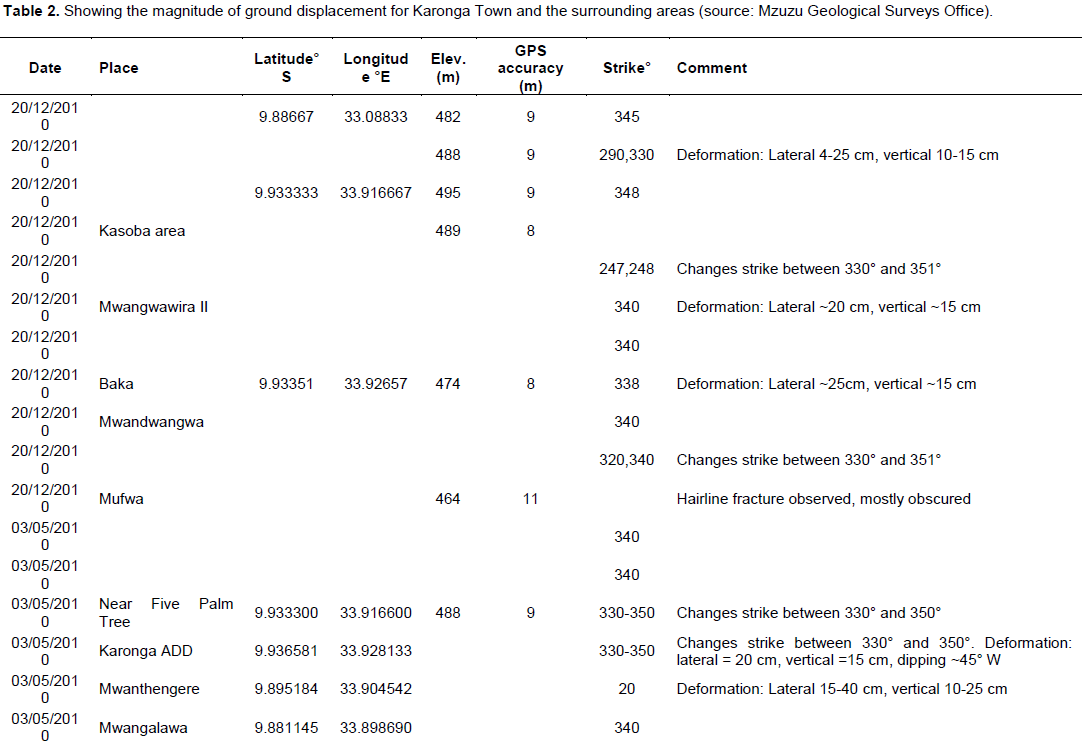
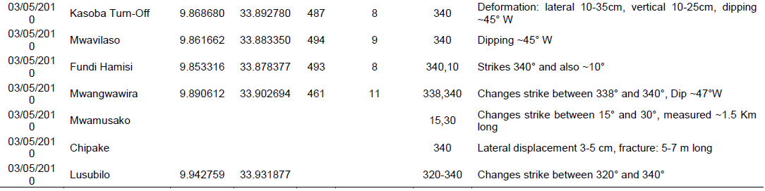
Data on earthquakes in Karonga has been collected since 1904 (Lunduka et al., 2010; Macheyeki et al., 2014). Figure 4 shows a number of epicentres since 1904 (Macheyeki et al., 2014). However the most reported earthquakes in the history of Malawi occurred in 2009 from 6th to 20th December (Tables 1 and 2). A post-mortem on earthquake report of 2009 indicates that the 6th December waves read 7.2 on Richter Scale. This is slightly different from the reading presented in the Karonga Urban Structure Plan (2013) which indicates that a strong earthquake of magnitude of 7.6 on the Richter scale also occurred on 20th December 2009 and damaged several buildings, roads and a flood control dyke along the Rukuru River. Both reports assert that these were surprisingly not the highest readings ever recorded for Karonga town as it noted to have ever recorded 7.4 Ms in 1910 (Macheyeki et al., 2014). The damage to the flood control dyke rendered the town unprotected from the floods in 2010/11. The differences in the readings reported show inconsistencies the recording processes and record keeping systems Malawi has and obviously will have planning and designing implication. It confirms arguments that Karonga did not have any working seismograph at the time the 2009 earthquakes occurred.
Going through the literature and records of seismic readings it was noted that data was recorded up to 2004 and resumed in 2009 after the earthquake occurred (Macheyeki et al., 2014). The five years of no records show the lapses in data collection and this obviously may have affected the implementation of building code and also the anticipation and prediction on the seismic hazard
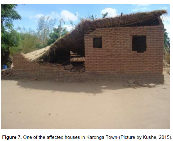
During the 2009 Karonga earthquakes field observation revealed a lot of structural failure which was mainly due to poor construction standards (Figure 7), that is, most of the structures in the area does not follow seismic standards (building codes). This poses a great risk hazard as the occurrence of a high magnitude earthquake in Karonga may result into high property damage and loss of life due to structural failure. Most of the structures / buildings in Karonga are seismically non-resilient and constructed on superficial deposits (Alluvium in Figure 1 and a profile in Figure 3B) which turn to amplify the earthquake shock thereby causing structural failure.
It is therefore necessary that construction of structures /buildings in seismic active areas like Karonga District should follow building codes as stipulated by the Malawi Bureau of Standards. On the other hand consideration should also be on peak ground acceleration (PGA) for different areas as indicated by Chapola (1997). Causes of earthquakes and their impacts
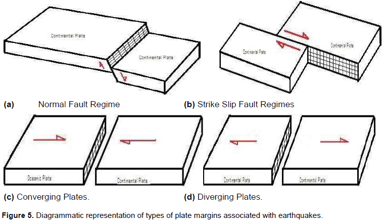
There are both natural and artificial processes that trigger earthquakes. Earthquakes triggered by natural processes are a result of geological processes (earth’s movement), that is to say, by volcanic activities or plate tectonics (de Blij and Muller, 1996). The theory of plate tectonics states that the outer rigid lithosphere consists of several individual segments called “plates” and it is these plates that are subjected to moving as a result of convectional cells / currents in the mantle (Mdala, 2011). The convectional cells get their energy from below the mantle (probably from the molten material magma). Earthquakes generated by plate tectonics are a result of movement of the plates along fault zones within the earth’s crust (Biggs et al., 2010). This means that the plates that make up the earth crust are in motion relative to each other, that is, either converging or diverging, these plates have sideways movement and in the process they cause crustal rocks to fold thereby producing features like fold mountains, block mountains and sometimes valleys some plates move towards each other and these are called converging plates, these plates converge under compression stress (Mdala, 2011). Other plates move past each other the transform / sliding plates in some cases plates may move vertically a process called rifting (de Blij, 1996), the vertical movement or up and downward movement cause the crustal rocks to fault thereby producing plateaus, block mountains, basins, some escarpment and the East African Rift Valley (Figure 3).
Earthquakes generated by volcanic activities are as a result of the molten rock material called magma. When magma is pushing its way through to the earth’s surface it exerts pressure and forces on the surrounding rock thereby causing them to break hence generating earthquakes or earth tremors in the process (Mdala, 2011). On the other hand artificial earthquakes are those that are triggered by human activities e.g. blasting in the mines, quarrying and nuclear or atomic explosions, these activities may generate earthquakes/earth tremors. In Malawi most earthquakes that have been occurring within the past years (and even recently) have been caused by natural geologic processes that are associated with the East African Rift System. The most destructive earthquakes are the ones that are caused / triggered by the movement along faults or fault fracturing (Mdala, 2011). Figure 5c and d are subjected to compression and tension forces respectively. Tension forces cause normal faulting while compression forces cause reverse faulting. The rift system of Malawi has a normal fault system; this means that it might have been subjected to tension forces that resulted into the formation of the normal faults within the rift (Mdala, 2011). The escarpment to the eastern side of Chiweta Mountains (Livingstonia Basin)and in some areas along the Malawi rift is an indication that the normal faulting of the rift system in Malawi was accompanied by vertical movement / displacement of the adjacent crustal blocks. In some areas along the Malawi Rift, the escarpment is not prominent this might be as a result of denudation forces that might have eroded the escarpment (Mdala, 2011).
METHODOLOGY
The study employed both qualitative and quantitative methods to collect data from purposefully selected stakeholders in Karonga Town. Data was collected through review of related literature, transect walks and stakeholder consultations. The stakeholder consultations involved interviews with heads and practitioners the key informants, such as chiefs and business people in Karonga Town. A total of 11 key informants were interviewed.
Seismographic information was collected from literature, records and reports and also interviews with experts from the geological surveys department, Mzuzu Office, the Karonga District council Community lead groups involved in earthquake hazard intervention were also interviewed to solicit information on knowledge perception and activities undertaken. The community leaders who were interviewed came from the following villages Mweniyumba, Katolola 1 and Katolola 2.
RESULTS AND DISCUSSION
Nature, scale and distribution of seismic/earthquake risks
The geological survey office based in Mzuzu is responsible for recording the seismographic information at all designated places in Karonga District and Karonga Town. They monitor all stations where seismic data is collected and report to the government through line department of geological surveys. Such information is used to explain extreme seismic hazards that occur in Karonga. However, it was revealed through the stakeholder consultation that the geological survey has never predicted the occurrence of earthquakes of particular magnitude. Information obtained from the geological surveys reports and key informants indicates that Karonga experiences seismic waves every year and in many years so many times. The epicentres of the earthquakes are wide spread in Karonga and are felt by neighbouring countries of Tanzania and Zambia (Figure 4).
The most recent and devastating earthquakes in recent years were experienced in 2009 where the Karonga Rapture was rejuvenated.
The magnitude of the seismic waves reached as high as 6.0 on Richter scale and had death fatalities in addition to the destraction of buildings across the district with more damage in the Karonga Town (Table 1).
According to the geological survey officials the earthquake had visible dispacements vertically and horizontally (Table 2). Such displacements result in damage a superstracture which exists on the line of propagation of the waves which result in such a displacement.
From interviews with officials of Karonga Town the tremors were experienced in successions from the 6th to 20th December, 2009. By 22 December 2009, the Government of Malawi had released a comprehensive report on the Karonga earthquake. The verbatim report read Mr. Mtambo of the DC office “2,752 houses were affected. Of these, 775 collapsed while 1,154 developed cracks. Also affected were 15 Police Mobile Force houses, 17 school blocks, 48 teachers’ houses, 1 Telecentre, 1 health post, 1 water point, 7 churches, 17 business centres and 2 mosques”.\
Further, the Karonga earthquakes were feared to adversely affect rice production as most of the 23,000 people the quake adversely affected and / or displaced are rice farmers in the rice growing areas. The Chairperson of the Water Users’ Association of Malawi, which is involved in rice irrigation farming, singled out Lufilya and Miyombo irrigation schemes as the hardest hit rice growing sites in the district. According to Harawa, the ‘’displaced farming families had fled to sites as far away as 10 to 15 km from their rice fields.’’
Estimates by President of the Farmers’ Union of Malawi, hinted on a massive 20% drop in rice production in Karonga in the 2009/2010 growing season following the displacement of farming families by the quake. ‘This obviously affected the people of Karonga Town as it is known for rice trading.’
Going through the records it was found that Karonga Town had been experiencing seismic waves since as way back as 1904 when the town was established as a trading centre. Mostly the epicentres for most earthquakes have been along the Karonga fault and the western shelf of the Lake Malawi on Karonga coast (Figure 4).
Although data of seismic waves exist, it is scanty and not consistent due to lack of functioning seismographs in some years. For instance, at the time of earthquake occurrence in 2009, there was no functioning seismograph in Karonga town. The most reliable information, recorded about the series of earthquakes was collected from remote seismographs and some information was collected from neighbouring countries and some even from Japan (Biggs et al., 2010).
Adequate understanding of the earthquakes in Karonga dates back from 1956 and since then information has been corrected for the seismic waves (Figure 6). Mostly the epicentres have been located on the western parts of Karonga but the Town has had the most serious readings due to the rapture which is associated with the Karonga fault (Figure 4).

A number of governmental and non-governmental organisations help people during earthquakes in Karonga. However the nature of support for residents of Karonga town was limited to relief items unlike in the rural area where houses were built by Red Cross. The office of the District Commissioner is central in the management of affected people to earthquake hazards and disasters. It coordinates the evacuation, relief operation and resettlement of victims. It uses government support to carry out the activities.
Other organisations involved in disaster management are CADECOM World Vision and other. Mostly these are also operating in rural areas leaving residents of Karonga town helpless.
According to the chiefs who were interviewed, an earthquake is treated as a male-being that travels with his wife. Under normal circumstances, the wife only accompanies the male earthquake. Under such circumstances, the earthquake does not strike an area with a lot of force. But when all the family accompanies him the earthquake strikes mercilessly.
An alternative view was that the earthquakes were a response to residents’ Government’s deaf ear to calls to stop uranium mining on Kayelekera. According to one resident, the earthquake could not have occurred had Government listened to locals in the district.
Biggs et al. (2010) reported that during the 2009 earthquakes, over 1000 houses collapsed while over 3000 had cracks, 4 people were killed by rubble and 300 people were wounded. The 6.0 earthquake could also be felt in Tanzania and Zambia. From interviews with people of Karonga Town the tremors were experienced in successions that had never happened before from the 6th to 20th December, 2009. This slightly differs from the report released on 22nd December 2009, which indicated that Karonga earthquake had 2,752 houses affected. Of these, 775 collapsed while 1,154 developed cracks. Also affected were 15 Police Mobile Force houses, 17 school blocks, 48 teachers’ houses, 1 Telecentres, 1 health post, 1 water point, 7 churches, 17 business centres and 2 mosques (GoM, 2009).
However, evidence on the ground shows that most houses damaged by 2009 earthquakes have low quality construction material which easily fail when earthquakes occur (Richardson, 2011). The process of rebuilding is solely left in the hands of household owners who are often undergoing economic hardships (Richardson, 2011).
According to the key informant (Business person in Karonga Town), it was noted that socio-economic and political factor play a big role in the creation of pressures which predispose households and communities to seismic risk. Negligence from the government was also noted as a source of risk to earthquake hazard. For example data collected from the geological surveys show that between 2004 and 2009 no information from seismographs was recorded. This means at the time of earthquakes in December 2009 no seismograph was located in Karonga especially the town. This implies there was no mechanism the people of Karonga town were going to be alerted of the changing pattern of seismic waves which give opportunities for anticipating the earthquake hazard.
A transect walk conducted in 2015 in the affected areas in Karonga reveal that most of the houses were still in a dilapidated form (Figure 5). A good number of the affected households indicated that they lacked enough funds to reconstruct their homes to meet the set standards.
Institutional arrangements
There are some organizations within the town which deal with hazards. These organizations use a cluster approach in dealing with these hazards. Some of these institutions include: Red Cross, Self Help Africa, World Vision, CADECOM among others (Table 3).
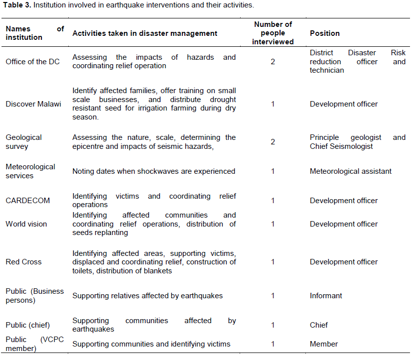
The stakeholders working in Karonga note that vulnerability to earthquake hazard has been aggravated overtime by the poor building standards and material which result in lack of or no enforcement of the building codes by the government in small town such as Karonga.
According to the District Council Officials there are a number of institutions and non-governmental organizations working in Karonga helping people to rebuild affected houses however none of them is working in Karonga town which has forced households in the town to build their dwelling houses poorly. The hazard map does not exist for Karonga Town and yet the Karonga fault and raptures have been adequately identified’ (Figure 3a and 4).
According to District Council Officials there are institution government structures which respond to disasters from grassroots at village level which report to area and then district level which report to the national level. The village civil protection committee notes the hazardous events in the communities assess the situation as quickly as possible and report to the areal civil protection committee (Figure 8).
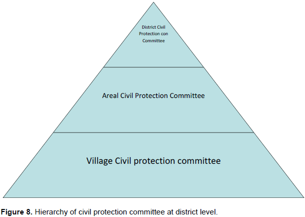
The areal civil protection committee receives reports from village civil protection committee assess the needs of the area reported to been affected by hazards and report to the District civil protection committee.
The district civil protection committee receives reports from the areal civil protection committee and determines the extent of the problem in the district. They determine the numbers of people affected by the hazard and determine the type and amount of support required to alleviate the problem. Such information with recommendations is presented to department of disaster risk management for consideration and support. If the situation is deemed a disaster the declaration is made and resources are pulled to the area.
Such institutional arrangements provide channels of communication and allows for delegation of power for interventions in times of disasters. However, according to Official from Cardecom these committees mostly function with bigger and perceivably large scale hazards and disaster. The district council official said: ‘’Small scale events go unnoticed and are considered not notifiable to authorities and yet they are the most prevalent and cumulatively build to constitute the vulnerability which the communities have.’’ This obvious have a bearing on the way people are impacted by these hazards as their resilience is weakened by such smaller events.
Knowledge of seismic hazards and associated risks
As part of the same project questionnaire interviews were carried out to assess the local perception on earthquakes from the surrounding community. In total representatives from three youth groups were interviewed and following is the feedback. A representative from the District Council Office (Desk Officer Disaster) was also interviewed in an effort to understand what mechanisms has the DC’s office put in place in relation to earthquake as a hazard in the district.
General observations
1. It was observed during interviews that almost all the participants gave similar answers.
2. It was also observed that the knowledge of the participants showed that they underwent basic education and were able to explain some aspects of earthquakes.
3. Of all the groups, representatives from Mweneyumba group gave interesting answers and vital suggestions on “what can be done to address in Karonga town”
Youth groups said that there is no specific institution or organization that deals with earthquake hazard risk within the district. However during the 2009/2010 earthquakes a number of organizations came in to help the affected population. This shows that despite their knowledge about what earthquakes are and how they occur they are not aware of government departments such are the geological surveys which monitors seismic waves in the area.
Interviewed on what measures to put in place before and after earthquakes
Respondents from all groups said that it is necessary that before an earthquake (1) all buildings should be constructed following a standard that can withstand the earthquake shock. (2) Evacuation centers must be created within the district. (3) People should be updated by the DC’s office on the current seismicity of the district. (4) The DC’s should have post-earthquake resources readily available, that is, tents.
After and during an earthquake respondents from all groups said that (1) it is necessary to stay away from tall structure, tress, etc. (2) If indoor stay under a study table or bed. (3) Sleep outside houses.
The district has set up some early warning systems which among them is the indigenous method. This method uses the behavior of animals, that is, during the prior stages of earthquake shock some animals shows a strange behavior, hence when people see this they get alerted and get prepared for the main shock. After the 2009/2010 earthquakes a safer building policy was adopted and Karonga district was sensitized on the same
CONCLUSIONS AND RECOMMENDATIONS
Karonga Town remains vulnerable to shocks aggravated by earthquakes since it is located on a fault line. Stakeholders’ understanding of the nature and scale of the seismic occurrence varies. Some understand earthquakes as caused by tectonic processes while others believe earthquakes are a punishment from the spirits for wrong doings. These different perceptions will not adequately mitigate the impacts and the after effects of earthquakes in Karonga. Adequate education and training to acquire knowledge of the earthquakes is required to help in better planning for the development and expansion of Karonga Town. Hazard map of Karonga Town should be made accessible to developers to reduce and avoid development on the fault line and rapture. Civic education is required Enforcement of building guidelines and codes should be a must.
CONFLICTS OF INTERESTS
The authors have not declared any conflict of interests.
ACKNOWLEDGEMENT
This work in part of the Urban Ark Research Project which in funded by DfID and ESRC, United Kingdom.
REFERENCES
|
Adelekan I, Johnson C, Manda MZ, Matyas D, Mberu BU, Parnell S, Pelling M, Satterthwaite D, Vivekananda J (2015). Disaster risk and its reduction: an agenda for Africa. Int. Dev. Plan. Rev. 37(1):33-43. |
|
|
Alexander D (2001). Natural Disaters, CRC Press, Tylor and Francis Group, USA. |
|
|
Ammon CJ (2010), Seismic Waves, Department of Geosciences, SLU, (Class notes). |
|
|
Biggs J, Nissen E, Craig T, Jackson J, Robinson DP (2010). Breaking up the hanging wall of a rift border fault: The 2009 Karonga earthquakes, Malawi. Geophys. Res. Lett. 37:11. |
|
|
Burke K, Gunnell Y (2008). The African Erosion Surface: A Continental Scale Synthesis of Geomorphology, Tectonics, and Environmental Change Over the Past 180 Million Years, Geol. Soc. Am. Mem. 201:1- 66. |
|
|
Carter GS, Bennet JD (1973). The Geology and Mineral Resources of Malawi. Bulletin No 6. Malawi Geological Survey Library, Zomba, Malawi. |
|
|
Chapola L (1997). State of stress in East and Southern Africa and Seismic Hazard Analysis of Malawi. Institute of Solid Earth Physics, |
|
|
De Blij HJ, Muller PO (1996). Physical Geography of the Global Environment (Second Eddition), John Wiley and Sons, Inc., New York. |
|
|
Ebinger CJ, Jackson JA, Foster AN, Hayward NJ (1999). Extensional basin geometry and the elastic lithosphere, Philos. Trans. R. Soc. A. 357:741-765. |
|
|
Flannery J, Rosendahl B (1990). The seismic stratigraphy of Lake Malawi, Africa: Implications for interpreting geological processes in lacustrine rifts, J. Afr. Earth Sci. 10(3):519-548. |
|
|
Geological Survey of Malawi (1966). Geological map of Malawi, scale 1/1,000,000, Geol. Surv. of Malawi, Lilongwe. |
|
|
Karonga Earthquake Report, 2009, Karonga District Council. |
|
|
Lunduka RW, Phiri MAR, Kambani C, Boyer C (2010). Malawi Disaster Risk Reductionand Climate Adaptation Research for CORDAID, Submitted to the Secretary General, Episcopal Conference of Malawi Lilongwe. |
|
|
Macheyeki AS, Mdala H, Chapola LS, Manhica VJ, Chisambi J, Feitio P, Ayeke A, Baronga J, Ferdinand RW, Ogubazghi G, Goitom B, Hlatywayo JD, Kianji GK, Maloble I, Mulowezi A, Mutamina D, Mwano JM, Shumba B, Tumwikirize I (2014). Active fault mapping in Karonga – Malawi after the December 0,2009, seismic event. J. Afr. Earth Sci. 102(2015):233-246. |
|
|
Malawi government (2013). Karonga Urban Structure Plan, Ministry of Lands and Housing Physical Planning Department, Lilongwe. |
|
|
Manda MAZ (2014). Where there is no local government: addressing disaster risk reduction in a small town in Malawi, Environment and Urbanization. |
|
|
Mdala H (2016). Map of Karonga showing epicenters, faults and a rapture Geological Surveys of Malawi, Mzuzu. |
|
|
Mdala H (2011). The Malawi Rift, Tectonics and seismicity. Zomba: Un-published. |
|
|
NSO (2010a). Malawi Population and Housing Census 2008: Main Report, Zomba Malawi. |
|
|
Richardson R (2011). Karonga Recovery Plan: Proposed development and amendments to the 'Guidelines for Safer House Construction, Malawi Red Cross. |
|
|
Shillington D (2010). Continental Breakup in East Africa – State of the Planet. |
|
|
Wisner B, Blaikie P, Cannon T, Davis I (2004). At Risk; Natural Hazards people's vulnerability and disasters (Second Edition), Routledge, Taylor and Francis Group, London and New York. |
|
Copyright © 2024 Author(s) retain the copyright of this article.
This article is published under the terms of the Creative Commons Attribution License 4.0


