African Journal of
Environmental Science and Technology

  • Abbreviation: Afr. J. Environ. Sci. Technol.
  • Language: English
  • ISSN: 1996-0786
  • DOI: 10.5897/AJEST
  • Start Year: 2007
  • Published Articles: 1126

Full Length Research Paper

Groundwater recharge and flow processes as revealed by stable isotopes and geochemistry in fractured Hornblende-biotite-gneiss, Rivirivi Catchment, Malawi

Dwight Kambuku
  • Dwight Kambuku
  • Graduate School of Life and Environmental Sciences, University of Tsukuba, Ibaraki 305-8572, Japan.
  • Google Scholar
Maki Tsujimura
  • Maki Tsujimura
  • Graduate School of Life and Environmental Sciences, University of Tsukuba, Ibaraki 305-8572, Japan.
  • Google Scholar
Shigeyoshi Kagawa
  • Shigeyoshi Kagawa
  • Society of Researchers for International Development, Tokyo, Japan.
  • Google Scholar


  •  Received: 14 August 2017
  •  Accepted: 29 September 2017
  •  Published: 31 January 2018

 ABSTRACT

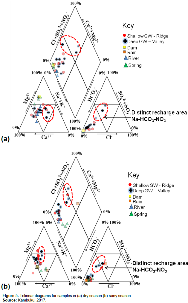
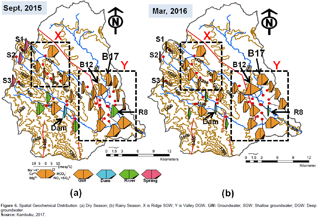
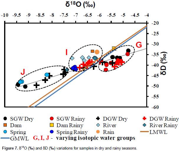
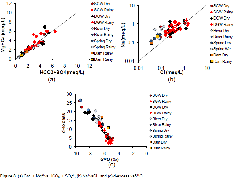
To enable sustainable management of groundwater resources, knowledge of dominant hydrogeological processes is fundamental. In this study, stable isotopes of water [δ18O  and δD] and major inorganic ions were used to investigate recharge and groundwater flow processes in a catchment underlain by fractured and faulted hornblende-biotite-gneiss. Spatial and temporal geochemical distributions consistently showed Mg-Ca-HCO3 dominated water facies. Evaporation was established to be the main process affecting isotopic enrichment in the study area. Stable isotopic and geochemical data revealed that a combination of thin overburden soil of up to 30 mm thickness and presence of fractures seem to enable localized rapid preferential recharge processes of isotopically enriched rainwater in shallow groundwater around the ridge section. However, the thicker overburden soil (up to 3 m) along the valley seems to allow only isotopically depleted large rain events to recharge deeper groundwater. The isotopically enriched small rain events seem to be allowed to evaporate before recharging groundwater in areas with thicker overburden soils. It was further established that the valley section also receives regional lateral groundwater recharge from high altitude areas. Regional groundwater flow system in the northwest-southeast (NW-SE) direction was thus established with local flows confirmed around the ridge section. It was also revealed that Ntcheu Fault acts as a conduit of regional groundwater flow in the NW-SE direction. Inter-aquifer connectivity and surface water and groundwater interaction were construed around the ridge section and around B12 and R8, respectively. The rapid recharge and flow phenomena in this type of geological media make the resource susceptible to pollution and inter-annual climatic variabilities. It is prudent therefore to consider such information when implementing other developmental plans in the catchment.


Key words: Groundwater recharge, groundwater flow, fractures, geological fault, stable isotopes, geochemistry, hornblende-biotite-gneiss, Malawi.


 INTRODUCTION

Drought, increased population and economic activities are continuously pushing communities to live in areas where groundwater from fractured rock aquifers is the only reliable source of potable water (Berkowitz, 2002). However, due to perceived lower yields of these aquifers, less attention is given to the understanding of the dominant hydrogeological processes (Mapoma and Xie, 2014). Due to lack of this information, fractured rock zones are sometimes used as disposal areas for radioactive waste (Neuman, 2005). In addition, since most of the fractured rock aquifers are shallow aquifers, usually up to 50 m deep (Guiheneuf et al., 2014), they are susceptible to inter-annual climate variabilities, particularly in drier environments (Lapworth et al., 2013). Understanding dominant hydrogeological processes in fractured rock formations is the first step to sustainable management of the resource regardless of climatic conditions.
 
Gleeson and Novakowski (2009) and de Vries and Simmers (2002) state that groundwater recharge and groundwater flow processes are generally controlled by climate, morphology and geological conditions. To this day, several researchers have looked at groundwater recharge and groundwater flow processes in various climatic regions and geological media, particularly those with a combination of permeable rock matrices and conductive fractures (Verbovsek and Kanduc, 2016; Roques et al., 2014; Monjerezi et al., 2011; Apaydin, 2010; Chilton and Foster, 1995). It was shown in these studies that basic assumptions regarding groundwater recharge and flow processes that are applicable to porous media are not necessarily relevant in fractured rock environments, especially at field scale. This is mainly due to heterogeneities within the fractured rocks.
 
In this regard, identifying the isotopic and geochemical fingerprints of the water molecule, rather than relying solely on hydraulic information, has proved to be useful in providing insights into characteristics of recharge and flow processes (Kamchueng et al., 2015; Zhang et al., 2014; Edoulati et al., 2013; Praamsma et al., 2009; Tsujimura et al., 2007). However, few studies to-date have investigated isotopic and geochemical characteristics of drier environments with a combination of thin overburden soil, fractured bedrocks and that are cut by geological faults (Stadler et al., 2010). Rivirivi Catchment in semi-arid Malawi provides a unique environment to study such phenomenon. The aim of this study therefore was to investigate how overburden soil condition, fractured rock formation and geological fault affect groundwater recharge and flow processes using distinctive fingerprints of δ18O (‰) and δD (‰) and major inorganic ions.


 METHODOLOGY

Study area
 
Geographic location
 
The area is located between longitudes 34° 34' 0''E and 34° 49' 0'' E and latitudes 14°  44'  0''S  and  15°  00'  0''S  and  on  the  border between administrative regions of central and southern Malawi (Figure 1). Upper Rivirivi Catchment covers an area of about 744 km2 and has an estimated population of over 72,000, 85% of which rely on groundwater sources (Knoema, 2015; MoAIWD, 2015). The elevation decreases from northwest towards southeast, ranging from 1,700 to 800 meters above sea level (masl) (Figure 1). It falls within the western branch of the East African Rift Valley system.
 
 
Climate
 
The study area has a dry sub-humid to semi-arid climate, with the higher areas receiving more rainfall than the low-lying locations. It has two main seasons, rainy season running from November to April and dry season from May to October every year. It receives a mean annual rainfall of 1060 mm. Average potential evapotranspiration (PET) is estimated to be 933 mm per year. Mean annual temperature varies from 14°C in June to around 24°C in October. The rain events are affected by three major synoptic systems; the Inter Tropical Convergence Zone (ITCZ), the Zaire Air Boundary (ZAB), and tropical cyclones. Like any location in Malawi, Rivirivi Catchment is equally vulnerable to the less predictable El Nino and Southern Oscillation (ENSO) phenomena (Chavula, 2012).
 
Geological setting
 
 
Basement complex rocks, mainly paragneisses, underlie the greater part of the area. These comprise hornblende-biotite-gneisses, often garnetiferous and locally containing a high proportion of epidote, biotite-nepheline-gneisses, quartzofeldspathic granulites, diopside-bearing gneisses, psammitic and peliticgneisses, charnockitic gneisses, marbles and thin bands of metadolerite. Ntcheu Fault and many other smaller local faults cut through Upper Rivirivi Catchment (Figure 2).  Most of the upper layer gneisses (about 50 m) is fractured (Figure 2) and may be assigned to the almandine-amphibolite metamorphic facies apart from the small areas of higher grade charnockitic granulite (Bloomfield and Garson, 1965). As a result, water is confined to narrow fault-zones, bands of pervious granulite or gneiss and local or regional pockets of superficial weathered rocks (Warshaw, 1965).
 
 
The study area has loam to sandy loam type of soils (Warshaw, 1965). The ridge areas (shallow groundwater zone) had thin overburden soils as opposed to valleys (deeper groundwater) which had relatively thicker overburden soils of up to 3 m. However, those located close to geological faults showed similar thin overburden soil conditions as those on the ridge (Figures 4 and 6). Outcrop fractures and fault zones were observed in the study area (Figure 3). Stratigraphic profiles constructed from lithological data obtained from the Department of Water Resources indicated the presence of fractured hornblende-biotite-gneiss even at depth (up to 60 m). Specifically, lithological data from borehole BP4 (01R124) that was drilled into Ntcheu Fault zone at Wanyemba village by District Development Committee in 1981, indicated the presence of decomposed clayey sand within the fractured biotite gneiss (Figure 3) (MoAIWD, 2015). These hydrogeological conditions are expected to be playing a crucial role in groundwater recharge and flow processes in the study area.


Sample collection
 
Two field surveys, one in dry season (September, 2015) and the other in rainy season (March, 2016) were carried out in Upper Rivirivi Catchment where a total of 64 groundwater samples, 10 river water samples, 2 dam water samples, 6 spring water samples and accumulated rain sample at Nkhande Weather Station were collected (Figure 3). During rainy season, the samples were collected a week after a major rainfall event. pH values (HORIBA Ltd., Twin PH Meter B121), total dissolved solids (TDS; hanna 50-HI9033), temperature (NikkyoTechnos Co. Ltd., Petten Kocher), and groundwater levels (dry season) were measured in situ. Portable Global Positioning System meter (GPS meter; GARMIN Ltd., GPSMAP 76S) was used to establish locations of the sampling points. The shallow groundwater sites (borehole screens located not deeper than 23 m and with thin overburden soils up to 30 mm) are mainly located along the ridge section while deeper groundwater sites (borehole screens located deeper than 23 m and with thicker overburden soils up to 3 m) are located along the valley section  and  close  to  Ntcheu.  Springs  are  located  in  the  higher altitude areas and are the sources of the perennial rivers (including Rivirivi River) in the catchment (Figure 3).
 
Analytical techniques
 
Since all groundwater samples were collected from production wells, they were collected an hour before the communities started using each well. By carefully avoiding any air intrusions, the samples were placed and sealed in a 100 mL polyethylene bottle each and transported to Japan (University of Tsukuba) for isotopic and major ions analyses. All the samples were analyzed for stable isotopes of water (δ18O and δD) using PICARRO L2120i Cavity Ringdown Spectrometer and values are herein reported as per mil (‰) deviations from Vienna Standard Mean Ocean Water (V-SMOW). In this analysis, the analytical reproducibility for δ18O and δD was better than 0.05 and 1‰, respectively. Major anions (Cl-, NO3- and SO42-) were measured using Ion Chromatograph (Shimazu Co., Ltd., HIC-SP/VP  Super)  while  major  cations  (Na+,  Ca2+,Mg2+,K+) were measured using Optima 7300 V ICP-OES Spectrometer (PerkinElmer Inc.). Bicarbonate (HCO3-) concentration was measured using a titration method with sulphuric acid (H2SO4). These analytical techniques are fundamental for stable isotopic and geochemical understanding of water resources (Kamchueng et al., 2015; Tsujimura et al., 2007).


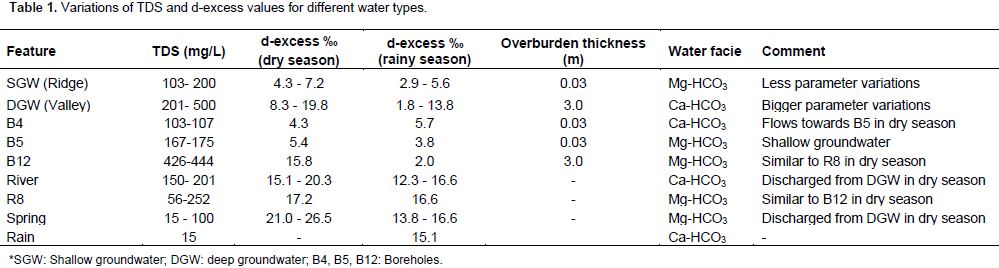
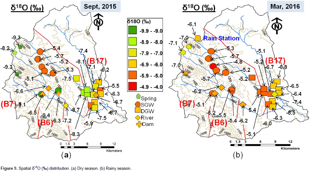
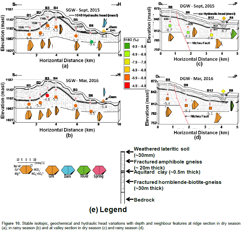
 RESULTS AND DISCUSSION

Geochemical compositions
 
Geochemical fingerprints have been shown to be good tools to constrain apparent evolutions along groundwater flow paths in a catchment (Gastmans et al., 2016; Edoulati et al., 2013; Mulligan et al., 2011). Spatial and temporal geochemical distributions in Upper Rivirivi Catchment showed that it is dominated by Mg-Ca-HCO3 water types. Shallow groundwater along the ridge section show Mg-HCO3 facies with Mg2+>Ca2+>Na+>K+ and HCO3->Cl->SO42->NO3- while deeper groundwater in the valley area shows Ca-HCO3 type in both dry and rainy seasons with Ca2+>Mg2+>Na+>K + and HCO3->Cl->NO3->SO42-. River water was consistently Ca-HCO3 dominated while spring water changed from Mg-HCO3 in dry season to Ca-Na-HCO3 in rainy season. B17 which is located near Nsipe River has a very distinct Na-HCO3-NO3 water type (Figures 5 and 6). During dry season, river water had similar concentrations as deeper groundwater while shallow groundwater had similar concentrations as spring water. In both seasons, however, concentrations of major ions in deeper groundwater remained higher than shallow groundwater and largely increased in concentration with decrease in elevation in the northwest-southeast (NW-SE) direction (Figure 6).


Stable isotopes
 
 
Clark and Fritz (1997) established that δ18O and δ2H (δD) fingerprints can provide insights into recharge and flow processes in a groundwater system since they are part of the water molecule itself and that any phase changes or fractionation along the flow path could also trigger change in its fingerprints. Figure 7 shows the seasonal relationship between δ18O and δD values of shallow groundwater (SGW) located along the ridge, deeper groundwater (DGW) located along the valley, river water, dam water, spring water and rain event. Data used to plot Local Meteoric Water Line (LMWL) was collected from Ndola International Atomic and Energy Agency's Global Network of Isotopes in Precipitation (IAEA GNIP) station in Zambia (IAEA, 2006) which has similar climate and altitude to Upper Rivirivi Catchment.


This is because the study area had no existing IAEA GNIP station at the time of this investigation. LMWL was constructed using weighted monthly rain data from November 1968 to December 2009 and yielded the equation:
 
LMWL: δD (‰) = 7.75(δ18O (‰)) + 9.68                                  (1)                                                
 
Which is closer to the global meteoric water line:
 
GMWL: δD (‰) = 8(δ18O (‰)) + 10 (Craig, 1961)                    (2)
 
Deeper aquifers (DGW) along the valleys  show  depleted values (up to -9.4‰) in dry season to enriched values (up to -5.1‰) in rainy season, while shallow groundwater (SGW) along the ridge showed enriched δ18O values in both dry and rainy seasons (-5.7 to -5.3‰). δ 18O  values for river water samples show small variations ranging from -7.2 to -6.5‰ in dry season and -7.4 to -6.2‰ in rainy season. Spring sample values however, show more depleted δ18O values similar to deeper groundwater located in the valleys, ranging from -9.3 to -8.2‰ in dry season and -7.4 to -7.0‰ in rainy season. δD values for deeper groundwater ranged from -49.7 to -38.7‰ in dry season and -41.3 to -38.3‰ in rainy season, while those for shallow groundwater ranged from -39.4 to -33.3‰ in dry season and -42.4 to -34.9‰ in rainy season.δD values for river samples ranged from -37.9 to -36.5‰ in dry season and -42.4 to -36.6‰ in rainy season.
 
Spring values ranged from -48.2 to -44.8‰ in dry season and -42.2 to -40.9‰ in rainy season (Figure 7). Shallow groundwater along the ridge exhibited the most enriched values in both seasons. The  variations  of  δ18O
 
and δD  in deeper groundwater were larger than those in river and shallow groundwater. The slope of the regression lines of the less varied shallow groundwater values was lower than that of LMWL, that is;
 
SGW:   δD (‰) = 6.3(δ18O (‰)) - 5.22                                     (3)
 
against
 
LMWL: δD (‰) = 7.75(δ18O (‰)) + 9.68.
 
This suggests that isotopic fractionation during rainwater evaporation could be the cause of the enrichment.
 
Dominant hydrochemical processes
 
 
Understanding the dominant hydro chemical processes in an aquifer is important when interpreting stable isotopic and geochemical data. Singh et al. (2017) stipulate that Ca2+ + Mg2+ versus HCO3- + SO42- plots can help understand the ion-exchange process occurring in an aquifer. Reverse ion-exchange tends to shift the points left of the equiline due to excess Ca2+ + Mg2+ while if ion-exchange is the main process, it will shift the  points  right of the equiline. Figure 8a shows that both reverse-ion exchange and ion-exchange are active processes in the study area. Figure 8b shows a stable 1:1 ratio of Na+/Cl- in shallow groundwater with some samples plotting below the equiline indicating that evaporation is the most active process happening in these locations. 95% of the samples plotted in Figure 8b have Na+/Cl- values around 1 indicating that evaporation is not only the most dominant process in shallow groundwater, but also in the other locations as well. This process is also confirmed by inverse relationship between d-excess values with δ18O as shown in Figure 8c. However, deep groundwater and river samples plotting slightly above 1:1 equiline in Figure 8b indicate that silicate weathering is another active hydro chemical process occurring in these locations. 
 
 
Ground water recharge and flow processes
 
 
Rock lithology and hydrogeological flow paths seem to affect geochemical concentrations in the study area (Figures 5 and 6). Table 1 shows that river, shallow groundwater and spring water samples have slightly lower total dissolved solids  (TDS)  concentrations  (up  to200 mg/L) than deeper groundwater (up to 500 mg/L) but similar to rainwater sample values. Monjerezi et al. (2011) in Lower Shire area, Malawi, demonstrated that such parameter variations can be attributed to differences in recharge areas and subsequent recharge processes and associated groundwater flow paths. In the present study, the seasonal decrease in TDS concentrations in shallow waters and the pronounced similarity with rainwater in rainy season (March, 2016) suggest that river water, shallow groundwater and springs are directly recharged from rainfall. These further indicate the role thin overburden soil and fractures play in preferential recharge processes along the ridge. Similar phenomenon is observed in boreholes along Ntcheu Fault (Figure 6). Generally, recharge in thick overburden soils might be delayed from months to several years (Praamsma et al., 2009).
 
 
In addition to the foregoing, Figures 7 and 9 show that the  variations  of  δ18O  and  δD  in  deeper  groundwater were larger than those in river and shallow groundwater in both dry and rainy seasons. This might be due to feature location differences, varied hydraulic conductivities and apparent different sources of recharge. As opposed to deeper groundwater, shallow groundwater showed less varied seasonal and spatial δ18O and δD  values. Its regression lines had lower slope than LMWL suggesting that isotopic fractionation during rainwater evaporation could be the cause of the enrichment. This further suggests that groundwater in the study area originates from precipitation. In addition, decreased d-excess values in shallow groundwater along the ridge (with thin overburden soil of up to 30 mm and visible fractures) and deep groundwater near Ntcheu Fault in the valley (Table 1 and Figure 10) seem to facilitate rapid preferential flow, allowing recharge from evaporated rainfall with a unique air mass infiltr te with ease. Table 1 shows that in dry season (September, 2015), river, spring and deep groundwater have similar increased d-excess values, suggesting that they have been  recharged  under similar relative humidity conditions. Deep groundwater seems to discharge into springs and rivers. This phenomenon is also observed in rainy season (March, 2016) when spring, river and some deep groundwater close to Rivirivi River (Table 1 and Figure 10d) have similar d-excess values with rainwater, suggesting that rainfall is the main source of recharge
 
Post-precipitation evaporation becomes an active process for isotopic enrichment when the transfer velocity from rainfall towards groundwater storage through soil and the unsaturated zone is sufficiently slow (Negrel et al., 2011). However, the situation is different when the geological formation has fractures. In this study, the thicker overburden soil (up to 3 m) seemed to ensure that only large rain events could recharge groundwater, maintaining that isotopic signal and letting small events evaporate without leaving any evaporation signal. A similar phenomenon was observed by Tsujimura et al. (2007) in semi-arid Mongolia. In Rivirivi Catchment, overburden soil thickness, fractures and boreholes proximity to faults  seem  to  be  dominant   features   affecting recharge processes. In the study area, geochemical concentration seems to increase with decrease in elevation in the NW-SE direction except around ridge area (Table 1 and Figure 6). Increased geochemical concentration is usually associated with longer groundwater flow paths as a result of rock-water interaction along the flow paths (Mulligan et al., 2011). Isotopic compositions also show simila-rities between springs in the high altitudes (-9.3 to -8.2‰ in dry season) and deep groundwater (-8.7 to -7.5‰) along the valleys suggesting hydraulic connectivity between these two locations.
 
 
Their d-excess values also show possibility of recharge under similar relative humidity conditions (Table 1), contrary to shallow groundwater that is located in-between them. This suggests existence of regional groundwater flow system and thus possibility of lateral fracture connectivity in the study area.  Hexa-diagrams, δ18O and δD  values of shallow groundwater along the ridge show distinct water type suggesting local flow system with geochemical concentrations increasing towards B1 and B5 (Figure 10a and b). Geochemical and isotopic data seem to suggest that the existence of thin overburden soil and surface fractures enable quick preferential flow system into frac-tured hornblende-biotite-gneiss along the ridge.  Wells B8 and B9 that are juxtaposed across Ntcheu Fault show similar stable isotopic compositions (-8.7 and -8.3‰ in dry season and -5.4 and -5.1‰ in rainy season). They also show hydraulic gradients across Ntcheu Fault in the NW-SE direction towards B9 and increased geochemical concentration in the same direction (Figure 10c and d). Lithological data from a borehole drilled in the fault itself at Wanyemba Village (BP4) shows permeable decomposed clayey sand formation across the fault (Figure 4). All these strongly suggest that Ntcheu Fault acts as a conduit of groundwater flow in the NW-SE direction. Inter-aquifer connectivity was suspected around the ridge section. Wells B4 and B5 which are drilled in different aquifers but are neighbour Features had  their  geochemical  and   is a topic compositions suggesting possibility of connectivity with groundwater flowing from B4 through the clay aquitard and towards B5 (Figure 10a and b). Geochemical and isotopic data also suggest surface water and groundwater interaction in the study area. In dry season (Table 1 and Figure 9a), deeper groundwater at B12 (-7.4‰ (δ18O); 15.8‰ (d-excess)  and   426  mg/L   (TDS))   has   similar parameters with its neighbour feature river sample site, R8 (-6.7‰ (δ18O); 17.2‰ (d-excess) and 252 mg/L (TDS)).


 CONCLUSION

Combination of isotopic and  geochemical  data  is shown to be a useful tool in understanding groundwater recharge and flow processes in varied geological environments. In this study, it was revealed that groundwater resource in Rivirivi Catchment is mainly controlled by overburden soil conditions, fracture connectivity, fault zones and underlying geology. Since  the  resource  is  in  a  shallow   fractured aquifer and that rapid preferential groundwater recharge happens along the fractured and thin overburden soil zones, it is susceptible to inter-annual climate variabilities and anthropogenic pollution. It is imperative therefore that, catchment management activities in fractured hornblende-biotite-gneiss are designed to reduce runoff and promote infiltration processes. It is also important that anthropogenic activities that may lead to pollution of groundwater resource be kept to a minimum. This includes the generalized idea of considering gneiss rock formations   as   nuclear   waste   disposal   sites   without thorough hydrogeological research.  Additional hydrogeological research work in Rivirivi Catchment is recommended to focus on hydraulic (pumping) tests to understand wells behavior over time. This will help further delineation of fracture connectivity in the study area. However, results from this study will add information to our understanding of how underlying geologies and overburden soils affect recharge and flow processes. These results are therefore expected to provide the springboard for further studies to enable comprehensive  water   resources   management   in  this data scarce catchment.


 CONFLICT OF INTERESTS

The authors have not declared any conflict of interests.


 REFERENCES

Apaydin A (2010). Relation of tectonic structure to groundwater flow in the Beypazari region, NW Anatolia, Turkey. Hydrogeol. J. 18:1343-1356.
Crossref


Berkowitz B (2002). Characterizing flow and transport in fractured geological media: A review. Adv. Water Resour. 25:861-884.
Crossref


Bloomfield K, Garson MS (1965). The Geology of Kirk Range - Lisungwe Valley area. Bulletin No. 17. Geological Survey Department. Zomba, Malawi.


Chavula GSM (2012). Groundwater availability and use in Malawi. In Groundwater Availability and Use in Sub-Saharan Africa: A review of 15 countries, Pavelic P, Giordano M, Keraita B, Ramesh V, Rao T. (Eds.). International Water Management Institute (IWMI). Colombo, Sri Lanka. pp. 78-90.


Chilton PJ, Foster SSD (1995). Hydrogeological characteristics and water-supply potential of Basement Aquifers in Tropical Africa. Hydrogeol. J. 3(1):36-49.
Crossref


Clark I, Fritz P (1997). Environmental Isotopes in Hydrogeology, CRC Press, Boca Raton, USA. P 342.


Craig H (1961). Isotopic variations in meteoric waters. Science 133:1702-1703.
Crossref


de Vries JJ, Simmers I (2002). Groundwater recharge: An overview of processes and challenges. Hydrogeol. J. 10: 5-17.
Crossref


Edoulati N, Boutaleb S, Bettar I, Ouchbani A (2013). Contributions of chemical and isotopic tools for understanding the groundwater modes of recharge and flow in the lower Cretaceous aquifer in the Moroccan Sahara. J. Water Resour. Protect. 5:183-199.
Crossref


Gastmans D, Hutcheon I, Menegario AA, Chang HK (2016). Geochemical evolution of groundwater in a basaltic aquifer based on chemical and stable isotopic data: Case study from the Northeastern portion of Serra Geral Aquifer, São Paulo state (Brazil). J. Hydrol. 535:598-611.
Crossref


Gleeson T, Novakowski K (2009). Identifying watershed-scale barriers to groundwater flow: Lineaments in the Canadian Shield. GSA Bulletin. 121(3/4):333-347.
Crossref


Guiheneuf N, Boisson A, Bour O, Dewandel B, Perrin J, Dausse A, Viossanges M, Chandra S, Ahmed S, Marechal JC (2014). Groundwater flows in weathered crystalline rocks; impact of piezometric variations and depth dependent fracture connectivity. J. Hydrol. 511:320-334.
Crossref


IAEA/WMO (2006). Global Network of Isotopes in Precipitation. The GNIP Database. http://nucleus.iaea.org/wiser/index.aspx


Kamchueng BT, Fantong WY, Wirmven WJ, Tiodjio RE, Takounjou AF, Asai K, Djomou BSL, Kusakabe M, Ohba T, Tanyileke G, Hell JV, Ueda A (2015). A multi-tracer approach for assessing the origin, apparent age and recharge mechanisms of shallow groundwater in the Lake Nyos catchment, Northwest, Cameroon. J. Hydrol. 523:790-803.
Crossref


Knoema (2015). Malawi Statistics. Available at: https://knoema.com/MWMS2011/malawi-statistics-2015


Lapworth DJ, MacDonald AM, Tijani MN, Darling WG, Goody DC, Bonsor HC, Araguas- Araguas LJ (2013). Residence times of shallow groundwater in West Africa: implications for hydrogeology and resilience to future changes in climate. Hydrogeol. J. 21:673-686.
Crossref


Mapoma HWT, Xie X (2014). Basement and alluvial aquifers of Malawi: An overview of groundwater quality and policies. Afr. J. Environ. Technol. 8(3):190-202.
Crossref


Ministry of Agriculture, Irrigation and Water Development (MoAIWD) (2015). National Water Resources Master Plan. CTI Engineering International Co., Ltd. Lilongwe, Malawi.


Monjerezi M, Vogt RD, Aagaard P, Gebru AG, Saka JDK (2011) Using 87Sr/86Sr, δ18O and δ2H isotopes along with major chemical composition to assess groundwater salinization in lower Shire valley, Malawi. Appl. Geochem. 26:2201-2214.
Crossref


Mulligan BM, Ryan MC, Cambara TP (2011). Delineating volcanic aquifer recharge areas using geochemical and isotopic tools. Hydrogeol. J. 19:1335-1347.
Crossref


Negrel Ph, Pauwels H, Dewandel B,Gandolfi JM, Mascre C, Ahmed S(2011). Understanding groundwater systems and their functioning through the study of stable water isotopes in a hard-rock aquifer (Maheshwaram watershed, India). J. Hydrol. 397: 55-70.
Crossref


Neuman SP (2005). Trends, prospects and challenges in quantifying flow and transport through fractured rocks. Hydrogeol. J. 13:124-147.
Crossref


Praamsma T, Novakowski K, Kyser K, Hall K (2009). Using stable isotopes and hydraulic head data to investigate groundwater recharge and discharge in a fractured rock aquifer. J. Hydrol. 366:35-45.
Crossref


Roques C, Bour O, Aquilina L, Dewandel B, Leray S, Schroetter JM, Longuevergne L, Le Borgne T, Hochreutener R, Labasque T, Lavenant N (2014). Hydrological behavior of a deep sub-vertical fault in crystalline basement and relationships with surrounding reservoirs. J. Hydrol. 509:42-54.
Crossref


Singh CK, Kumar A, Shashtri S, Kumar P, Mallick P (2017). Multivariate statistical analysis and geochemical modeling for geochemical assessment of groundwater of Delhi, Inida. J. Geochem. Explor. 175:59-71.
Crossref


Stadler S, Osenbruck K, Suckow AO, Himmelsbach T, Hotzl H (2010). Groundwater flow regime, recharge and regional-scale solute transport in the semi-arid Kalahari of Botswana derived from isotope hydrology and hydrochemistry. J. Hydrol. 388:291-303.
Crossref


Tsujimura M, Abe Y, Tanaka T, Shimada J, Higuchi S, Yamanaka T, Davaa G, Oyunbaatar D (2007). Stable isotopes and geochemical characteristics of groundwater in Kherlen River basin, a semi-arid region in eastern Mongolia. J. Hydrol. 333:47-57.
Crossref


Verbovsek T, Kanduc T (2016). Isotope Geochemistry of Groundwater from Fractured Dolomite Aquifers in Central Slovenia. Aquat. Geochem. 22:131-151.
Crossref


Warshaw RD (1965). The Geology of Ntcheu-Balaka area. Bulletin No. 19. Geological Survey Department, Zomba. Malawi.


Zhang Y, Li F, Zhao G, Li J, Zhu O (2014). An attempt to evaluate the recharge source and extent using hydrogeochemistry and stable isotopes in North Henan Plain, China. Environ. Monit. Assess. 186:5185-5197.
Crossref


          */?>