Full Length Research Paper

ABSTRACT
Very Low Frequency Electromagnetic (VLF-EM) and electrical resistivity surveys were conducted at Modomo/Eleweran, along Ede-road, south western Nigeria, with a view to delineate the hydrogeophysical characterization of the study area. The area is underlain by the Precambrian Basement Complex rocks. The VLF-EM traverses were established along 6 traverses with a station interval of 10 m with lengths ranging from 130 to 360 m. Linear features presumed to be geologic fissures inferred from the filtered real pseudo-sections helped in selecting twenty-nine VES points that were further probed using ABEM SAS 300 C Resistivity Meter. The spreading were carried out using the convectional Schlumberger electrode configuration with half-current electrode separation (AB/2) varying from 1 to 100 m was used for the sounding. The VES data were presented as depth sounding curves and were appropriately iterated using RESIST version (1.0) software. The VLF filtered real profile displayed a low peak trend depicting poor or no fracture signature. Four lithological formations were delineated which included the topsoil, weathered layer, partly weathered/fractured basement and fresh bedrock. The delineated weathered and fractured basement columns constituted the aquifer units. Additionally, from the geophysical parameters viz a viz thin overburden thickness, clayey weathered layer and low fractured frequency characterized by the study area, it is inferred that the groundwater potential of the area varies between poor and low. However, the study justified the use of a combined geophysical investigation as a better tool in evaluating the groundwater potential in the basement complex.
Key words: Weathered layer, geological fissures, aquifer, electrical resistivity, geoelectric section, electromagnetic.
INTRODUCTION
Groundwater has been described as water which occurs in the vadoze zones (Fitts, 2002) which filled the pore space of soil and fissure below the water table (Freeze and Cherry, 1979). This can be extracted by boreholes and hand-dug wells occur in a highly permeable geological formation known as aquifers which have properties that allow storage and movement of water (Eduvie, 2006).
However, the study area is underlain by the Precambrian Basement Complex rocks where groundwater occurs either in the weathered mantle or in the joint and fracture systems in the unweathered rocks (Olorunfemi and Olorunniwo, 1985; Dan-Hassan and Olorunfemi, 1999). The highest groundwater yield in basement terrain is found in areas where thick overburden overlies fractured zones (Olorunniwo and Olorunfemi, 1987). These zones are often characterized by relatively low resistivity. However, the indiscriminate sinking of boreholes without employing systematic scientific approach, that is, pre-drilling geophysical investigation has led to unsuccessful boreholes with poor or low yield (Bayode et al., 2007).
The study area has been experiencing a rapid rate of development due to its proximity to the Obafemi Awolowo University (OAU) Campus. This has led to an increase in the higher demand for potable water especially during dry seasons. The incessant failure in many boreholes sunk in this area necessitates the need for a detailed geophysical investigation to delineate suitable aquifers for groundwater development in the area.
Naghibi et al. (2015) studied the use of statistical models viz a viz frequency ratio (FR) and Shannon's entropy (SE) and machine learning models to map the groundwater potential in an underground tunnels, springs and semi-deep wells. However geophysical method has been found widely applied in much hydrogeophysical investigation because of its fast and non-invasive approach especially in a basement complex basement. Hence, an integrated geophysical approach involving the Very Low Frequency (VLF) Electromagnetic and Electrical Resistivity methods was used in this study to delineating geological deep fissures or crevices that may allow accumulation of groundwater.
The major objective of the study is to apply an integrated geophysical approach in evaluating the groundwater potential of the area. However the electromagnetic (VLF) method has been applied extensively as a rough and rapid reconnaissance tool in groundwater investigation especially in basement complex terrain.
The electrical resistivity method on the other hand has been used as a tool to provide a geoelectric picture of the subsurface sequence of a particular area of interest. Also the groundwater accumulation potential in a basement complex terrain has been statistically evaluated from geoelectric parameters using the Schlumberger Vertical Electrical Sounding (Oyedele and Olayinka, 2012).
Physiography and geology
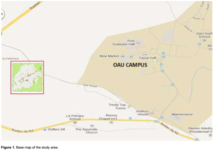
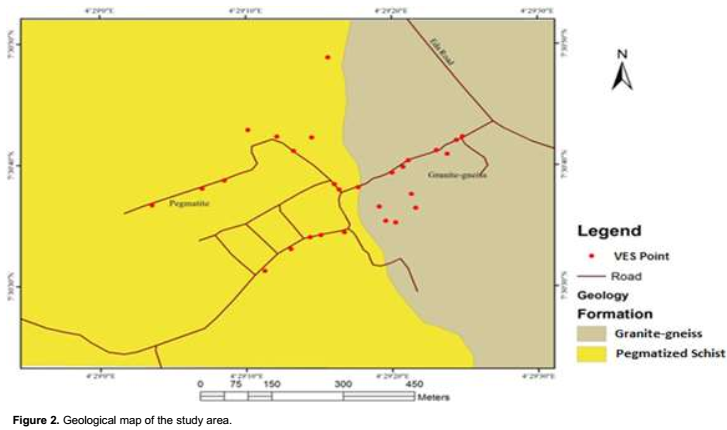
Modomo/Eleweran has an aerial extent of 0.52 km2 and is located between latitudes 7° 30/ 30// N and 7° 30/ 52// N and longitudes 4° 29/ 10// E and 4° 29/ 35// E. The study area is accessible through a dirt road emanating from a left flank of Ife-Ede road (Figure 1). The study area is underlain by the Precambrian Basement Complex rocks of southwestern Nigeria (Rahaman, 1976; Nuhu, 2009). The main geological unit in the area is the dark, greenish grey granite-gneiss and pegmatite veins. The granite-gneiss rock belongs to the Migmatite gneiss complex which constitutes one of the major rock units of the Precambrian Basement of the southwestern Nigeria (Nuhu, 2009) (Figure 2). The topography of the study area consists of a gentle plain with a topographic elevation of less than 300 m above sea level. In a typical basement complex terrain, groundwater is confined within weathered layer and or fractured/jointed or sheared basement columns (Afolayan et al., 2004). Groundwater development in such a geological area is a function of the weathered layer thickness, its clay content and the magnitude of fractures.
MATERIALS AND METHODS
Geophysical survey and data processing
Very Low Frequency Electromagnetic (VLF-EM) measurements were made using GEONICS EM-16 equipment. NAA Cutler Maine USA transmitter with frequency range of 24 to 27 KHz was used as a based station (McNeill, 1980). The instrument measured the field generated as a ratio of secondary magnetic field to primary magnetic field caused by the presence of the N anomaly (target). Six traverses were cut with station intervals of 10m along NE-SW, W-SE, SE- NW, NE-SW, NE-SW and NW-SE direction to effectively monitor the subsurface inhomogeneity. The real raw (real part of the signal) collected were further subjected to a filtering process to generate the filter real and the imaginary part (Quadrature) data (Olayanju et al., 2009). The filter real in addition with the raw data was plotted against distance to generate the VLF-EM profiles. The interpreted results of the VLF-EM field measurements helped in selecting the locations of vertical electrical soundings.
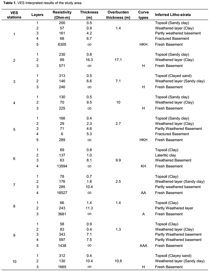
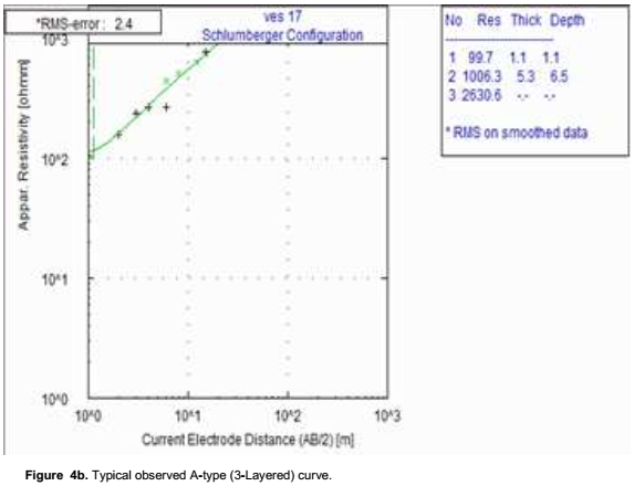
Twenty-nine Vertical Electrical Sounding (VES) stations were probed in the area using conventional Schlumberger configuration. Field measurements were acquired with ABEM Signal Averaging System (SAS) 300 C Terrameter Resistivity Meter. The apparent resistivity obtained was plotted on a log-log graph paper with the electrode separation (AB/2) on the abscissa and apparent resistivity (ρa) values as the ordinate. The true resistivity and thickness of the subsurface layers were interpreted by partial curve matching with the two layer model master curves and the corresponding auxiliary curves. The thickness and resistivity values obtained from the partial curve matching were then used for a quantitative computer iteration using the Resist Software algorithm RESIST version1.0 (Velpen, 1988). The results obtained from the computer modeling are presented in Table 1. The iterated geoelectrical parameters obtained (Table 1) were used to generate geoelectric sections and contour maps for the study area in accordance with the analysis of geo-electrical data by Oyedele et al. (2013) in their work to generate groundwater potential map in a complex basement.
RESULTS AND DISCUSSION
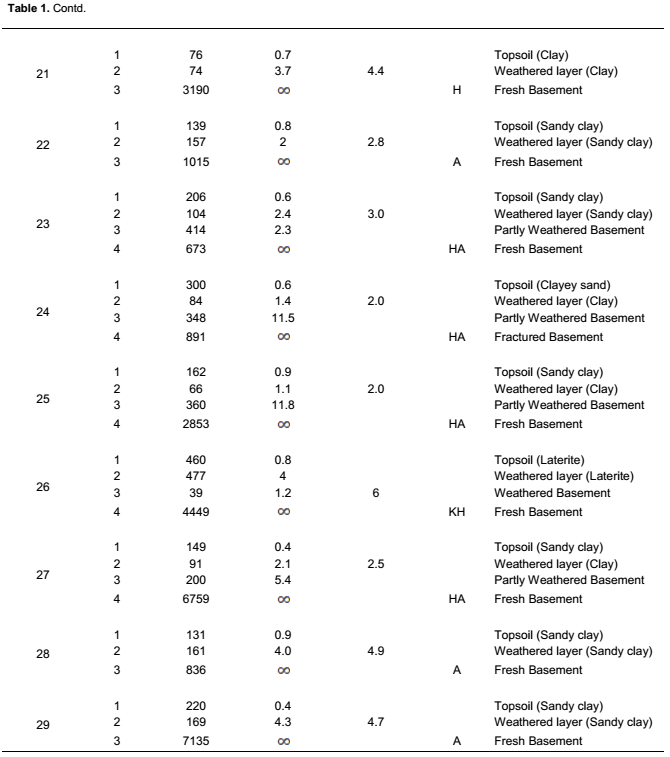
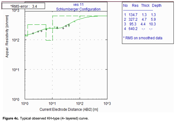
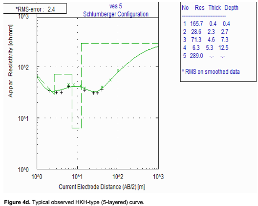
The acquired data were processed and subjected to detailed interpretation aimed at unraveling the subsurface conductivity and/or resistivity in the study area. Conductive features, which are characterized by appreciably positive filtered real VLF-EM profile peaks (Figure 3a to f), were interpreted as probable geologic fissures capable of holding significant quantity of water. The EM profiling shows that the VLF-EM anomaly varies from -42 to -4 and -16 to 18 in the raw real and filtered real components, respectively. The VLF filtered real profiles displayed peak values of less than 18% indicating poor or no fracture signature. The results of the electrical resistivity data are presented as sounding curves (Figure 4a to d). Eight VES curve types were identified in the area revealing four geo-electric layers consisting of the topsoil, weathered layer (clay/sandy clay/laterite), partly weathered/fractured basement and fresh basement.
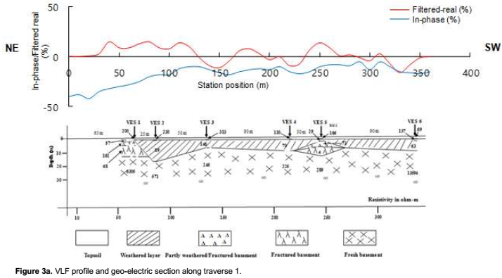
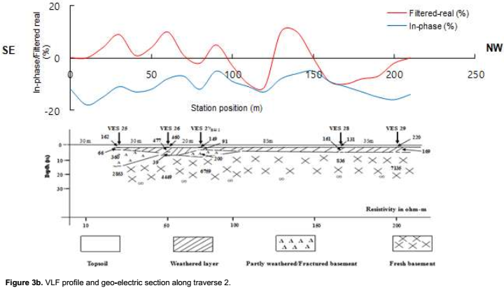
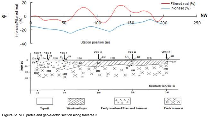
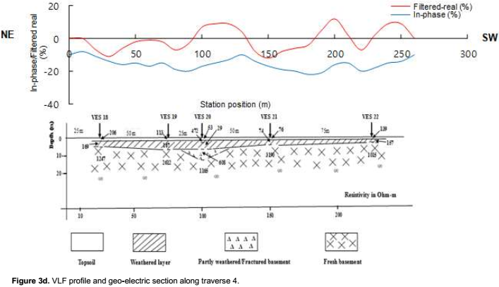
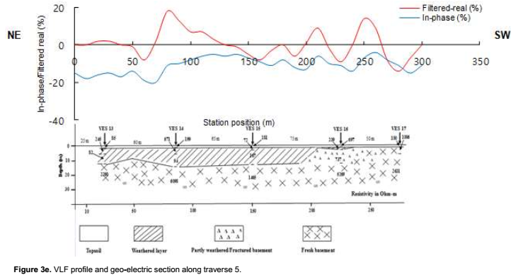
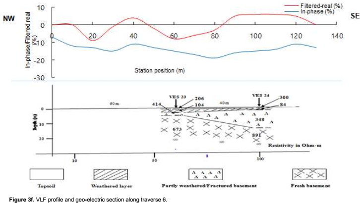

The study area is also characterized by topsoil resistivity values which range between 53 and 697 Ωm with thickness ranging from 0.4 to 1.4 m. The weathered layer resistivity varies between 29 and 243 Ωm with thickness ranging from 0.4 to 16.3m. The resistivity of the weathered layer reflects the variable composition of clay, sandy clay and laterite while the resistivity values of the fresh basement range between 225 and 16527 Ωm.
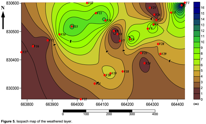
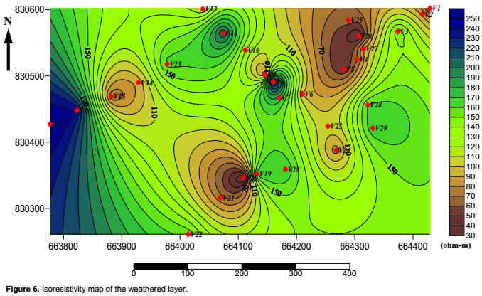
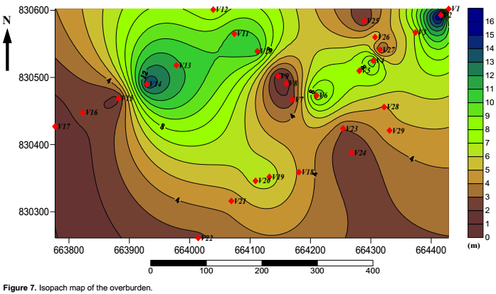
The isopach and isoresistivity maps of the weathered layer (Figures 5 and 6) respectively depicted a high composition of clayed materials except beneath VES5 where the inferred lithology was partly weathered basement and fractured basement (Oyedele et al., 2013). The inferred lithology also suggests a good fissured basement with accumulation of water (good aquiferous unit) due to a very low resistivity indicated compared to other VES location beneath by fractured basement. The presumed aquifer corroborates with the existing drilled borehole 2 (BH 2) which happened to be the only viable of all existing boreholes drilled in the area. The isopach map of the overburden (Figure 7) depicted marked resemblance to that of the weathered layer with respect to thickest and thinnest portions. The thickest and thinnest portions of the weathered layer and the overburden correspond to the depression and the ridges respectively on the bedrock relief map which also depicted the direction of groundwater flow. The spatial map is in corroboration with the study reported by Oyedele et al. (2013) in their analysis of geo-electrical data to generate spatial distributions of relevant geo-electric parameters to map groundwater potential in a complex basement of Southwest Nigeria.
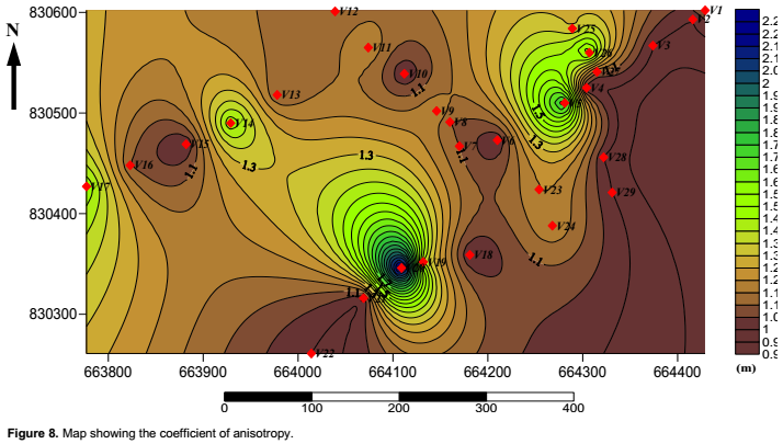
In addition, the coefficient of anisotropy map revealed the location beneath VES5, VES14, VES19, VES20 and VES26 with coefficient of anisotropy 1.8, 1.5, 1.4, 2.3 and 1.6 respectively indicating a presumable fractured basement (Figure 8). However the higher resistivity depicted in these locations suggests a probable fractured lineament due to a joint (strike) feature between Pegmatite and Granite-gneiss from the geological map passing through the locations with very low or no fissured characteristics. While location beneath VES5 indicating a very low resistivity depicting probable aquifer unit.
In general, the study revealed the groundwater potential of the area to be generally low with limited hydrogeological significance.
CONCLUSION AND RECOMMENDATIONS
An integrated geophysical investigation conducted at Modomo/Eleweran area, Osun State revealed the lithological formation to be made up of topsoil, weathered layer (consisting of clay, sandy clay and laterite), partly weathered/fractured basement and fresh basement rock. It was observed that the area is characterized by a thin overburden thickness, clayey weathered layer and low fracture fracture signature. Due to the moderate overburden thickness, lower weathered layer resistivity and high anisotropy value observed in location beneath VES5 and VES20, it can be inferred that these locations would be favourable zones for sitting a borehole. Based on the result of this study, it is clearly shown that the groundwater potential of the area varies between poor and low. Further extensive geophysical survey should be carried out in locations around VES2, VES14 and VES20 with a wider spread to probe into the fractured basement. In addition drilling to the basement is suggested in order to tap the reserved groundwater within the vadoze and fractured zones. However, the study established the advantage of a combined geophysical investigation as a better tool in evaluating the groundwater potential in the basement complex.
CONFLICT OF INTERESTS
The authors have not declared any conflict of interests.
ACKNOWLEDGEMENTS
This research work was reviewed by Professor Martins. O. Olorunfemi of the Department of Geology (Applied geophysics), Obafemi Awolowo University, Ile-Ife, Osun State, Nigeria. Also a full support of Dr. M.O Awoyemi of the Department of Physics, Obafemi Awolowo during the survey was highly commendable. However, the effort of (Late) Mr. Olawore Stephen during the geophysical survey will forever be appreciated.
REFERENCES
|
Afolayan JF, Olorunfemi MO, Afolabi O (2004). Geolelectrical/Electromagnetic VLF survey for groundwater development in a Basement terrain case study. Ife J. Sci. 6(1):74-78. |
|
|
Bayode S, Ojo JS, Olorunfemi MO (2007). Geophysical exploration for groundwater in Ejigbo and its environs, southwestern Nigeria. Glo. J. Geo. Sci. 5(1,2):41-49. |
|
|
Bourhane A, Comte JC, Join JL, Ibrahim K (2016). Groundwater prospection in Grande Comore Island Joint contribution of geophysical methods, Hydrogeological Time-series analysis and Groundwater modeling. In active volcanoes of the Southwest Indian Ocean 385-401. Springer Berlin Heidelberg. |
|
|
Comte JC, Cassidy R, Nitsche J, Ofterdinger U, Pilatova K, Flynn R (2012). The typology of Irish hard rock aquifers based on an integrated hydrogeological and geophysical approach. Hydrogeol. J. 20(8):1569-1588. |
|
|
Dan-Hassan MA, Olorunfemi MO (1999). Hydrogeophysical investigation of a Basement terrain in the north-central part of Kaduna state, Nigeria. J. Min. Geol. 35(2):189-206. |
|
|
Eduvie MO (2006). Borehole failures and groundwater development in Nigeria. A paper presented at a National seminar held on the occasion of water Africa exhibition Nigeria (2006) at Ikoyi hotels and suites, Victoria Island, Lagos, on 15th November, 2006. |
|
|
Fitts CR (2002). Groundwater science. Academic, San Diego. |
|
|
Freeze RA, Cherry JA (1979). Groundwater. Prentice-Hall, Englewood Cliffs Geological ordinal survey (1966). Sheet No. 60. |
|
|
McNeill JD (1980). Technical note (TN-6) Electromagnetic terrain conductivity measurement at low induction numbers. Geonics limited. 1745 Meyerside drive, Mississauga, Ontario, Canada. |
|
|
Naghibi SA, Pourghasemi HR, Pourtaghi ZS, Rezaei A (2015). Groundwater qanat potential mapping using frequency ratio and Shannon's entropy models in the Moghan watershed, Iran. Earth Sci. Inform. 8(1):171-86. |
|
|
Nuhu GO (2009). Geology and Mineral resources of Nigeria. Lecture Notes in Earth sciences. Springer Dordrecht Heidelberg. London New York. |
|
|
Olayanju A, Omosuyi GO, Ako BD (2009). Electromagnetic Profiling And Electrical Resistivity Soundings In Groundwater Investigation Of A Typical Basement Complex-A case study of Oda town Southwestern Nigeria. Ozean J. Appl. Sci. 2:4. |
|
|
Olayinka AI, Olorunfemi MO (1992). Determination of geoelectrical characteristics in Okene area and implications for Borehole sitting. J. Min. Geol. 28(2):403-412. |
|
|
Olorunfemi MO, Olorunniwo MA (1985). Geoelectrical parameters and aquifer characteristics of some parts of southwestern Nigeria. Geologia Applicata. E. Hydrogeologia. 20(1):99-109. |
|
|
Olorunniwo MA, Olorunfemi MO (1987). Geophysical investigation for groundwater in Precambrian terrains; A case history from Ikare, southwestern Nigeria. J. Afr. Earth Sci. 6(6):787-796. |
|
|
Oyedele EAA, Oyedele T, Oyedele K (2013). Geo-electrical data analysis to demarcate groundwater pockets in Ado–Ekiti, southwest, Nigeria. Int. J. Water Resour. Environ. Eng. 5(11):609-615. |
|
|
Oyedele EAA, Olayinka AI (2012). Statistical evaluation of groundwater potential of Ado-Ekiti, southwest Nigeria. Transnatl. J. Sci. Tech. 2(6):110. |
|
|
Rahaman MA (1976). A review of the Basement geology of southwestern Nigeria. In Kogbe CA. (Editor), Geology of Nigeria. Elizabethan Pub. Co. pp. 41-48. |
|
|
Van Der Velpen BPA (1988). Resist Version 1.0, M.Sc. Research Proj. ITC, Netherlands. |
|
Copyright © 2024 Author(s) retain the copyright of this article.
This article is published under the terms of the Creative Commons Attribution License 4.0


