ABSTRACT
Bush fires are increasingly becoming a threat to Guinean ecosystems and their understanding is a big challenge to scientists and environmental managers. Using the FARSITE model (Fire Area Simulator), this paper presents the prediction of the spread and characteristics of bush fires in the savannahs of North-eastern Guinea, specifically in Malea/Siguiri prefecture. Inputs, vegetation and topography dataset from satellite imagery (30 m resolution, Landsat and SRTM respectively) as well as in-situ meteorological data (wind, temperature and humidity) were used. These data obtained from the boundaries of the area of study were prepared using Geographic Information System (GIS). The burning time and the ignition points were fixed while admitting 3 scenarios: spread of fire in a plain without wind; spread on hills without wind effect and spread with wind effect. The results show that, in these savannahs, the intensity of the fire lines can reach 4133,3 KW/m under the effect of winds. Without winds, a decrease of 69% over plains and 68% over hills is noted. The amount of heat released could go up to 38000 KJ/m2 with the wind effect. While, without the wind effect a decrease of 10 and 9% over the plains and hills is observed respectively. Eventually, the speed of propagation reaches 8 m/min (0.5 km/h), but without the wind, it would decrease up to 73 and 61% over plains and hills, respectively. This study could be improved to serve as a decision support tool for the management of ecosystems North-eastern Guinea.
Key words: Fire area, prediction modeling, simulator, ecosystem managers, Guinea.
The study of bush fires is more and more concern in the world because of its many environmental and social consequences. In Guinea, the sharp decline in forests due to anthropogenic pressure and climatic variability raises concerns in terms of understanding fires that threaten the environment. The southern and southwestern parts of Guinea are so-called forest areas, while the north and north-east are practically savannah regions that are regularly covered by fires for the benefit of hunting and agropastoral activities.
Bushfires, apart from their harmful effects on ecosystems, are an important source of greenhouse gas emissions and aerosols in the atmosphere (Trabaud, 1974; Monnier, 1981; Achard et al., 2002). These emissions strongly affect the climate, the earth's radiation balance, air quality, human health and the economy (Chandler, et al., 1983). These are concerns for many researchers, in the fields of climatology, risk prevention and forest management (Breton et al., 2008; Thonat, 2013). Previous study in the field of fire observation has already greatly contributed to the understanding of their spatio-temporal distribution and their recurrence in the North-east of Guinea, more specifically in the county of Siguiri (Millimono et al., 2017), to the estimation of burned areas and their predictability (Barry et al., 2015; 2018).
Siguiri, a county located in the north-east of Guinea bordering Mali, is a gold producing area where activities requiring the use of fire (cleaning of gold mining areas, subsistence-oriented farming and livestock, coal production, etc.) are various. Its vegetation is mostly grassy and shrubby with rare forest galleries. During the dry season (November to May), a fire breaks out on such a landscape, stirred up by the wind can consume little grass, brush, branches.... But which way will it go? How fast will it spread depending on the land, wind speed and direction, type of vegetation? How much heat would it release on average? This is what forest managers and firefighters are keen to know to organize prevention and control more effectively. Nowadays, computer simulation of fire could not only make it possible to know approximately the evolution of a fire in progress in order to recommend the appropriate method and means for its extinction; but could also be used in preventive development plans to reduce the risks of fire damage (Achard et al., 2002; Forghani, 2007). The illustrations are better in relation to the texts as part of the sensitization on bushfires.
This article does not intend to build a model from scratch; to critically review existing models or provide an exhaustive list of all past work, since many works have been done in these issues (Pastor et al., 2003; Sullivan, 2008; Mohamed, 2013). In this paper we rather try to highlight the usefulness of the FARSITE model for predicting fire behavior in northeastern Guinea, especially over Malea, so as to produce useful information for environmental protection.
The FARSITE model used is a deterministic two-dimensional fire growth model that allows explicit spatio-temporal representation at the landscape scale (Rothermel, 1972; Finney, 1998; 2004). FARSITE uses the Rothermel model, which has been developed from a solid theoretical basis to make its application as broad as possible. This basis was provided by Frandsen (1971) and Rothermel (1972), who applied the principle of energy conservation to a unit volume of fuel upstream of an advancing fire in a homogeneous fuel bed. Their analyses led to the following:


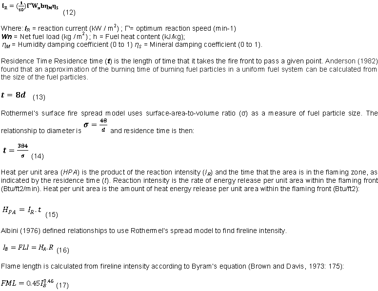
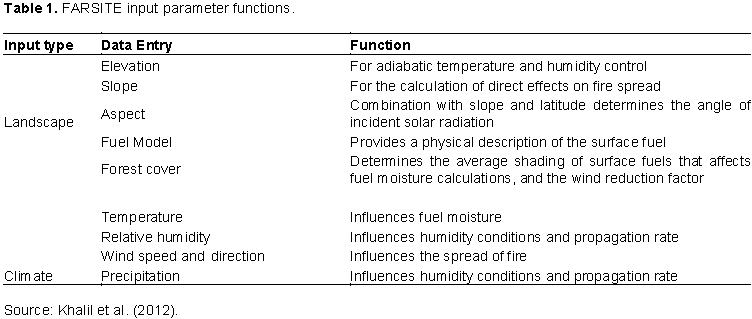
FARSITE predicts the rate of spread and intensity of fire reaction in a continuous layer of fuel adjacent to the ground. It uses a fuel input model that describes the fuel types and physical characteristics to predict ignition, a topography file and weather file that are factors influencing propagation (Table 1). The landscape groups the mandatory model parameters while the climate forms the group of model forcing parameters also known as optional parameters (Stratton, 2009). The FARSITE outputs on which we based the fire behavior analysis are: Time of Arrival (.TOA in hours); Fire line Intensity (.FLI in kW/m); Flame Length (.FML in m) ; velocity or Rate of Spread (.ROS in m/min) ; heat per unit area (.HPA in kJ/m2) ; the Reaction Intensity (.RCI in kW/m2); the Spread Direction (.SDR in degrees azimuth) and the Crown- No Crown (.CFR The units are: 1 for a surface light, 2 for a passive top light, and 3 for an active top light).

FARSITE, like most fire forecasting models, has been calibrated and validated in the United State in the different ecosystems of the Mediterranean basin (Moretti, 2015). Its operation requires the use of a Geographic Information System (GIS).
In the "FARSITE" fire spread model, standard fuel models or custom fuel models can be used. The custom fuel model is applied when the standard fuel model does not match the vegetation characteristics in a study area. The characteristics of the fuels flammability are incorporated in the simulator for standard fuel models between 1 and 13, and only the weather parameters and the topography vary significantly from one medium to the other, thus influencing the spread and characteristics of fire. Any vegetation with approximately the same characteristics as these where model was developed may have nearest neighbor fuel numbers (Anderson, 1982). The comparison is made according to the type of vegetation. For fuel totally different from the standard fuel model, a custom fuel model is recommended to hope to produce good simulation. The choice of Maléa takes into account these criteria. In this study, the standard fuel model was selected for two reasons:
(i) The vegetation of the selected Malea area meets Anderson's fuel classification criteria (Anderson, 1982).
(ii) The implementation of a customized fuel model requires large resources for the detailed study of vegetation types (case of plant formations in central, south-eastern and south-western Guinea). We therefore focused on this Siguiri area for this first stage of our fire behavior prediction.
Regarding the relief, Siguiri is an area with plain, plateau and hills. According to meteoblue link (https://www.meteoblue.com), the temperature maxima in this area on oscillate between 29 and 40° and the minima between 20 and 26° depending on the month. The wind speed at 12 m switches between 0 and 91 km / h, the amount of rainfall in the area varies between 0 and 100 mm / month.
In this study area, the layers of grass are more or less dry during the dry season which runs from November to May; the high occurrence of fires in this zone is observed between December and January.
Methods
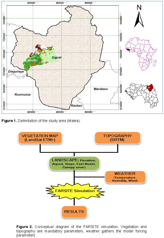
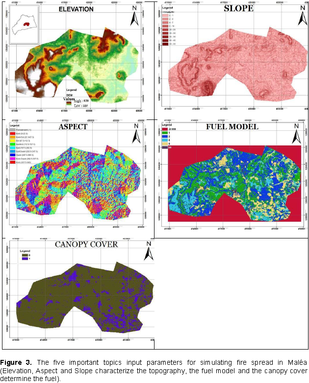
We focused our work on a plot of land in the Malea sub-county, Siguiri County, located in Northeast Guinea (Figure 1). The FARSITE Landscape was developed by integrating the fuel model, canopy, elevation, exposure and slope into each FARSITE cell frame. The weather and wind data were adapted before the simulation started. This conceptual diagram (Figure 2) summarizes the different steps leading to the results.

In the conceptual diagram of the FARSITE simulation, vegetation and topography are mandatory parameters; weather gathers the model forcing parameters (Figure 2). For the topography, the 30 m resolution Shuttle Radar Topography Mission (SRTM) was used to produce the elevation maps (For adiabatic temperature and humidity control in FARSITE), slope (for the computation of direct effects on fire spread) and aspect (For determining the angle of incident solar radiation) of the study area using the Spatial analysis tool in ArcGIS 10.0. These relief parameters are constants for a given area (Figure 3). They significantly influence the propagation and their knowledge is essential for any FARSITE simulation. The slope of the terrain produces the same effect as the wind (Ali et al., 2012). In general, as the slope increases, the rate of spread increases, and fires burn more quickly on uneven slopes. The slope exerts a considerable influence on the speed of propagation, especially in the early stages of a fire, so the speed of propagation of a fire will double on a slope of 10% and quadruple by climbing a slope 20%; on the other hand it is considerably reduced when a fire goes down over a slope (Trabaud, 1970).
P < 15%: Low slope with no impact on propagation
15% < P < 30%: Medium slope causing moderate acceleration of the fire front
30% < P < 60%: Strong slope causing a strong acceleration of the fire front
P > 60%: Very steep slope with risk of turbulence, fire jump, general embrace by stains (Ali et al., 2012).
Considering that topography is a static parameter, the main issues are related to the definition of fuel characteristics and the reconstruction of weather conditions. These fuel layers (grass and woody) in this area are supposed to be more or less dry. Predicting fire behaviour by simulation requires detailed knowledge of the fuel as this is the key parameter for any simulation activity with FARSITE (Eva and Fritz, 2003; Lopez Blanco, 2014). Since the characteristics of this fuel cannot be accurately assessed at every point in the study area, it is useful to use a fuel typology and thus categorize it. A landsat ETM+ image with a spatial resolution of 30 m × 30 m covering the area was the subject of a supervised classification which made it possible to categorize the types of vegetation (grasses, shrubs, trees) which are the fuels by referring to existing standards (Keane et al., 2000). The information provided by the Landsat image and thanks to our field knowledge, with reference to Anderson's fuel classification (Anderson, 1982), to highlight six element classes in our study area, namely:
1= short grasses about 30 to 50 cm high;
2= shrubs and undergrowth;
4= shrub field,
9= hardwood litter,
98= water;
-999= no data
A variable declaration with ArcGIS made it possible to establish the useful correspondence taken into account by FARSITE such as:
1=FM1,
2=FM2,
4=FM4,
9=FM9,
98=water ;
-999= missing data.
FM stands for Fuel Model. Fuel model and canopy provide a physical description of the surface fuel bed (Figure 3). In fire ecology, canopy or canopy cover is generally estimated as a percentage and grouped into four categories (Nelson, 1997).
0= no canopy;
1= 1 to 20% canopy;
2= 21 to 50% canopy;
3= 51 to 80% canopy; and
4= 81 to 100% canopy.
The fuel model made it possible to map the canopy based on two considerations:
(i) Not all grassy areas have canopy
(ii) The shrub and wooded savannah layers have 1 to 20% canopy
The flora cover map or fuel model was then resampled to obtain the canopy (Figure 3) and converted to ASCII format for use in the FARSITE model. Canopy or forest cover. It governs the average shading of surface fuels that affects fuel moisture calculations, and the wind reduction factor.
0=0% no canopy,
1= 1 to 20% canopy.
Winds in the area are very variable and it is an essential factor that provides oxygen, transfers heat by tilting the flame, transports fire over long distances. The wind (Speed ​​and direction per hour), temperature and humidity (Maximum and minimum per day) values included in the model were obtained on the meteoblue site data. These files are readable under the spreadsheet WordPad which was also used for their organization and adjustment. All these files were converted to ASCII (text file) format before being aggregated to FARSITE.
Simulating a fire situation in the FARSITE model requires a point or points of ignition as the starting point of the fire and a duration that is necessary for the start and end of the fire. The ignition points were chosen according to three scenarios:
(i) Ignition and propagation without wind in a space without slope (by canceling wind values in the lowland area)
(ii) Ignition and propagation with wind in a space without slope (lowland area)
(iii) Ignition and wind-free propagation in a slope space (by canceling wind values)
We based our calculations on these three scenarios to clearly show the influence of winds and slopes in fire prediction by maintaining the same time pace. The simulation with FARSITE requires a lot of other calibration processes (see the FARSITE help tool at each step).
Spatial propagation of fires over Malea
Scenario 1: Ignition and windless spread in an environment without slope
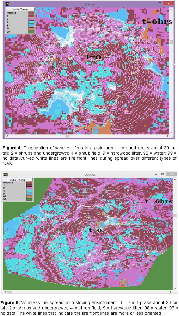
Assuming for this first scenario, the absence of the wind by approximation, FARSITE describes exactly what could be observed by experience in the field. The fire would take a quasicircular form and the deformations of the fire front would depend only on the density and the type of fuel and their moisture content (Figure 4). The small intervals between the fire fronts of time t = 0 (firing phase) and t = 6 (hours) end of combustion phase would explain the low rate of propagation in the absence of wind. One can also note the consideration by FARSITE conditions of limitation of the propagation which are among others: the presence of water or fuels too wet to be burned. It is noted in the figure by strong deformations and strong approximations of the fronts of fire.
Scenario 2: Ignition and propagation without wind in a sloping environment
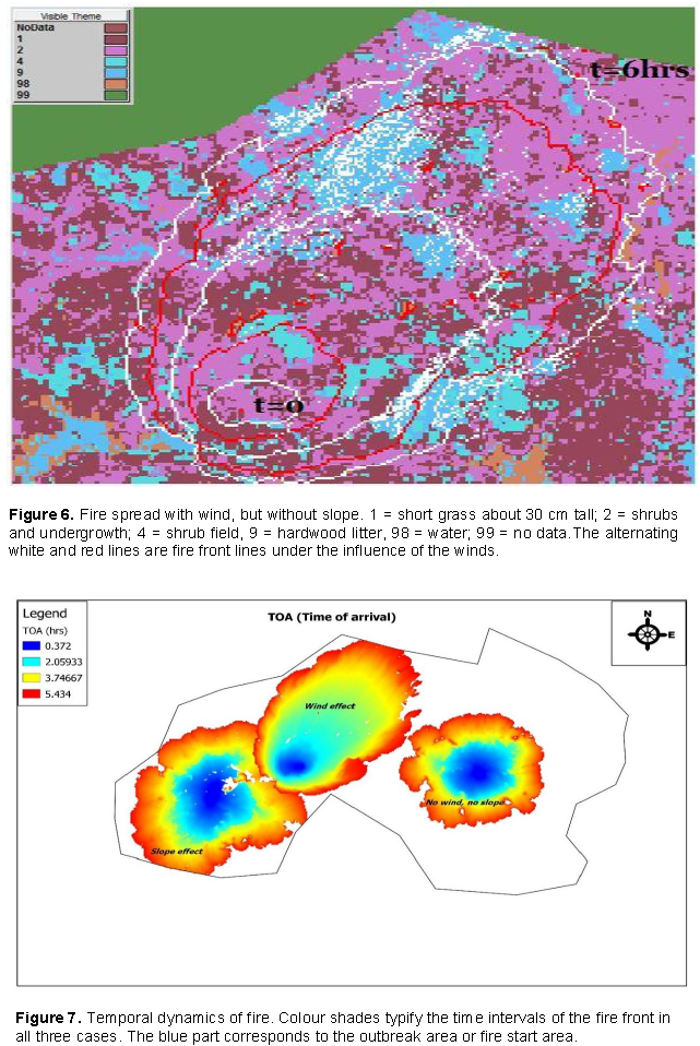
For the second scenario, always keeping the approximation of the absence of the wind, if the environment is almost made up of the same fuel complex, the slopes positively influence the propagation (Figure 5). Fire rises faster from the slopes and thus increases its rate of propagation, which therefore becomes higher than that of lowland environments. It is also noted that the propagation rate is higher than that of the scenario 1.
Scenario 3: Wind ignition and Fire Spread
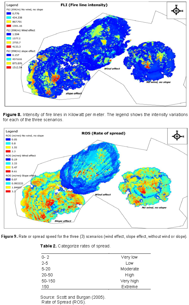
The third and last scenario of our observation is that of propagation under the influence of winds (Figure 6). Contrary to scenario 1 and 2, the lines of fire favor a direction that is none other than that of the winds. However, we observe that although the effect of wind minimizes the effects of fuel moisture, the limitations due to water and the area too wet remain observable in the figure, which shows the sensibility of FARSITE. Under the influence of wind, we notice that the effect of wind minimizes the effects of humidity and even those due to the type of fuel. Fire imposes itself and evolves rapidly. In addition to this prediction of spatial spread, we got into the analysis of some other fire behaviours, like time of arrival, spread direction, fire line intensity, reaction intensity, rate of spread and amount of heat released.
Fire behavior analysis over Malea
We processed with GIS software, some outputs of the FARSITE model to predict some fire characteristics during the observed spreading. To facilitate observation, we have grouped the three scenarios at each stage of analysis.
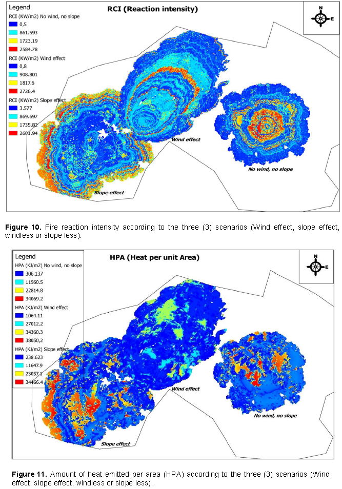
(i)Time: For a duration of 6 h planned during the initialization, we notice that the progression of the fire varies according to the scenario. For the same time intervals, the distances covered in scenario 1 are very identical in all directions. In scenario 2 (slope effect), these distances vary according to the degree of inclination and the other characteristics of the fuel. With the effect of the wind, one can observe for the same time steps, great distances are traveled towards the direction of the wind, and short distances of side opposite the wind (Figure 7). Figure 7 shows that for the same time interval, fire propagation is very quick in the presence of wind and slopes. According to Seigue and Drouet, (1982) and Ali et al. (2012), land slope produces the same effect as the wind. This is true in our case. The fire propagation time projection in our area is a good indicator for foreseeing possible provisions for the safety and properties protection.
(ii) Fire Line Intensity: The intensity of the fire lines depends mainly on the characteristics of the fuel. The type of fuel, its moisture content and its degree of combustion characterize the firepower. The supply of oxygen by the wind is also a key parameter (Figure 8). The intensity of the fire lines can be a function of fuel type, wind and slope, and moisture content. For the same moisture and the same types of flora, the intensity of the fire lines varies according to the speed at which the fire spreads. According to the Canadian Wildland Fire Information System link (http://cwfis.cfs.nrcan.gc.ca/cartes/fb), the calculation of this intensity is based on the rate of spread as well as the total combustion of the fuel. The same source indicates that the intensity of the fire lines can exceed the value of 30 000 KW/m depending on wind speeds and the degree of combustion of the fuel.
(iii) The rate of spread: The rate of spread or speed of fire depends on the type of fuel, the degree of humidity, but especially the wind speed and the topography. This speed is at first very low at the beginning of the fire, and it becomes more and more considerable. Figure 9 shows a slight difference between the propagation speeds without wind, no slopes and those without wind, but with slope. One can note that the slopes in our study area are more or less weak as shown in Figures 2 and 3. This is why the propagation rates are close during propagation without wind or slopes and with slopes. Wind, on the other hand, is a major factor in the spread. We observe that the propagation rate takes the values reaching approximately 8 m/min.
Scott and Burgan (2005) categorize rates of spread as follows (Table 2). Without wind, the rate of spread will be low in this area. The presence of winds increases the spread rate which then becomes moderate. This rate can be high when wind speeds increase.
(iv) Reaction intensity: This is the power released by the fire per unit area. This power varies momentarily and its characteristics relate to those of the lines of fire, with the only difference that the latter varies in unit of surface. The intensity of the reaction generally depends on the temporary oxygen supply from the air layers. This contribution is often favoured by the effects of the wind, which explains the very contrasted aspect of the propagation pattern with the effect of the wind (Figure 10). On the other hand, the intensity of the reaction also depends on the type of fuel and the momentum of the fire.
(iii) Heat per unite area: This quantity depends a lot on the degree of combustion. Beyond the emissions of particles and gases, fire emits a large quantity of heat which depends on several factors (type and density of fuel, speed of spread, degree of combustion...). Figure 11 predicts the amount of heat emitted per square kilometer for the following scenarios. Wind, through its multiple actions, plays an important role in the outbreak and spread of fires (Trabaud, 1970; Blin, 1974; Stratton, 2009). By its intensity, speed and direction; wind favours and accelerates the drying out of plants and soils; curves and revives flames; brings heat to adjacent fuels; increases the speed of propagation and can produce summit fires that are difficult to control; sometimes transports very far incandescent particles (Trabaud, 1992; Cochrane et al., 2012). For a given fire, the higher the wind speed, the greater the flame spread speed (Trabaud, 1970). It is also interesting to note that the effect of slopes is very similar to that of winds. Fire spreads faster in steeply sloping areas than on plains. Water and bare soil are natural barriers that limit the spread of fire. FARSITE simulation therefore predicts fire behavior with the aim to plan prevention or suppression strategies.


The modeling of spread and behavior fire in the Malea area (Siguiri) prefecture with FARSITE tool (Fire Area Simulator) was possible by crossing satellite data (Landsat, SRTM) with weather data (wind, temperature, humidity). The GIS softwares made it possible to organize this data before integrating it with FARSITE for simulation.
The results obtained show that, in the absence of the wind, the fire would spread more or less uniformly in all directions, the spread of rate would vary between 0.05 and 2.3 m / min and the heat released during combustion would be between 300 to 34000 Kj / m2, with a power ranging from 0.7 to 1000 KW / m. The presence of slopes would increase the rate of propagation, the power and the heat released by the fire according to the degrees of inclination.
In the presence of winds, the propagation rate could reach the value of 8m / min with a power ranging between 1 and 4000 KW / m. The heat released would be of the order of 38,000 KJ / m2. For the direction of propagation, the fire in the absence of the wind would have more or less the same probabilities of directional evolution. The wind and the slopes would determine the preferred directions according to their orientation. These results are in harmony with the ordinary observations, which prove the performance of FARSITE (Fire Area Simulator) in the study of fire dynamics and behavior. Although these results are limited by the quality of the data used (weather data in a Siguiri scale), they nonetheless open up a perspective of understanding the fire risks in this area. A detailed study of fuel types and climatic parameters by zone would allow this work to be pursued towards other complex ecosystems of the country in order to limit the damage caused by bush fires.
The authors have not declared any conflict of interests.
REFERENCES
|
Achard F, Eva HD, Stibig HJ, Mayaux P, Gallego J, Richards T, Malingreau JP (2002). Determination of deforestation rates of the world's humid tropical forests Science 297(5583): 999-1002.
Crossref
|
|
|
|
Albini FA (1976a). Estimating wildfire behavior and effects. USDA Forest Service, Intermountain Forest and Range Experiment Station Ogden, Utah, INT-30. 92 p.
|
|
|
|
|
Ali K, Ali S (2012). Simulation numérique du comportement des feux de forêt par le logiciel.
|
|
|
|
|
Anderson HE (1982). Aids to determining fuel models for estimating fire behavior Gen Tech Rep INT-122 Ogden Utah: US Department … https://www.fs.fed.us/rm/pubs_int/int_gtr122.pdf
|
|
|
|
|
Barry MB, Badiane D, Diakhaté M, Sall SM, Senghor H, Millimono TN (2018). Variability and predictability of bush fire in Guinea on inter-annual and multi-year timescales based on NDVI-MODIS datasets analysis. African Journal of Environmental Science and Technology 12(12):514-522.
Crossref
|
|
|
|
|
Barry MB, Badiane D, Sall SM, Balde ML, Millimono T, Diaby I, Diallo D (2015). Apport d'une méthode de détection et d'estimation des surfaces brulées par imagerie modis: application aux savanes guinéennes Revue scientifique de l'université Julius N'yéréré de Kankan.
|
|
|
|
|
Blin P (1974). Le Vent Revue Forestière Francaise Numero Special—Les Incendies de Forêts. pp. 130-139.
|
|
|
|
|
Breton T, Duthen Y (2008). Les simulations de propagation de feu en milieu urbain halarchives-ouvertesfr.
|
|
|
|
|
Chandler C, Cheney P, Thomas P, Trabaud L, Williams D (1983). Fire in forestry Volume 1 Forest fire behavior and effects Volume 2 Forest fire management and organization John Wiley & Sons Inc.
|
|
|
|
|
Cochrane MA, Moran CJ, Wimberly MC, Baer AD, Finney MA, Beckendorf KL, Zhu Z (2012). Estimation of wildfire size and risk changes due to fuels treatments International Journal of Wildland Fire 21(4):357-367.
Crossref
|
|
|
|
|
Eva H, Fritz S (2003). Examining the potential of using remotely sensed fire data to predict areas of rapid forest change in South America Applied Geography 23(2-3):189-204.
|
|
|
|
|
Finney MA (1998). FARSITE: Fire Area Simulator-model development and evaluation Res Pap RMRS-RP-4 Revised 2004 Ogden UT: US Department of Agriculture Forest Service Rocky Mountain Research Station 47 p 4.
|
|
|
|
|
Finney MA (2004). FARSITE: Fire Area Simulator–Model Development and Evaluation United States Department of Agriculture Forest Service Rocky Mountain Research Station Research Paper RMRS-RP-4 Revised March 1998 revised February forests Science 297(5583):999-1002.
|
|
|
|
|
Forghani A, Cechet B, Radke J, Finney M, Butler B (2007). Applying fire spread simulation over two study sites in California lessons learned and future plans In Geoscience and Remote Sensing Symposium 2007 IGARSS 2007 IEEE International (pp 3008-3013) IEEE.
|
|
|
|
|
Keane RE, Mincemoyer SA, Schmidt KM, Long DG, Garner JL (2000). Mapping vegetation and fuels for fire management on the Gila National Forest Complex New Mexico Gen Tech Rep RMRS-GTR-46 Ogden UT: US Department of Agriculture Forest Service Rocky Mountain Research Station 126 p 46.
|
|
|
|
|
Lopez Blanco E (2014). Assessing the Potential of Embedding Vegetation Dynamics into a Fire Behaviour Model: LPJ-GUESS-FARSITE Lund University GEM thesis series.
|
|
|
|
|
Millimono TN, Sall SM, Badiane D, Bah A, Diakhate M, Toure I , Diaby I (2017). Analysis of bushfires spatial and temporal variability in Guinea Atmospheric and Climate Sciences 7(04) :463.
|
|
|
|
|
Mohamed D (2013). Un modèle de propagation de feux de végétation à grande échelle (Doctoral dissertation Université de Provence-Aix-Marseille I).
|
|
|
|
|
Monnier Y (1981). La poussière et la cendre Paris Agence de Coopération Culturelle et technique 253 p.
|
|
|
|
|
Moretti B (2015). Modélisation du comportement des feux de forêt pour des outils d'aide à la décision (Doctoral dissertation Université Pascal Paoli).
|
|
|
|
|
Nelson R (1997). Modeling forest canopy heights: The effects of canopy shape Remote Sensing of Environment 60(3): 327-334.
Crossref
|
|
|
|
|
Pastor E, Zárate L, Planas E, Arnaldos J (2003). Mathematical models and calculation systems for the study of wildland fire behaviour Progress in Energy and Combustion Science 29(2):139-153.
Crossref
|
|
|
|
|
Rothermel RC (1972). A mathematical model for predicting fire spread in wildland fuels.
|
|
|
|
|
Seigue A, Drouet JC (1982). Incendies de forêt. publisher Association Forêt Méditerranéenne, 14 rue Louis Astouin, 13002 MARSEILLE, France. IV: N°2.
View
|
|
|
|
|
Scott JH, Burgan RE (2005). Standard fire behavior fuel models: a comprehensive set for use with Rothermel's surface fire spread model Gen Tech Rep RMRS-GTR-153 Fort Collins CO: US
|
|
|
|
|
Stratton RD (2009). Guidebook on LANDFIRE fuels data acquisition critique modification maintenance and model calibration Gen Tech Rep RMRS-GTR-220 Fort Collins CO: US Department of Agriculture Forest Service Rocky Mountain Research Station 54 P 220.
|
|
|
|
|
Sullivan AL (2008). A review of wildland fire spread modelling 1990-present ArXiv Thomas PH Pickard RW Fire spread in forests and heathland materials Report Forest Research.
|
|
|
|
|
Thonat T (2013). Etude des feux de biomasse tropicaux: observation simultanée des gaz émis par les feux à l'aide des observations hyperspectrales de AIRS et IASI (Doctoral dissertation Palaiseau Ecole polytechnique).
|
|
|
|
|
Trabaud L (1970). Le comportement du feu dans les incendies de forêts.
|
|
|
|
|
Trabaud L (1974). Experimental study on the effects of prescribed burning on a Quercus coccifera L garrigue: early results In Proceedings.
|
|
|
|
|
Trabaud L (1992). Réponses des végétaux ligneux méditerranéens à l'action du feu Pirineos 140:89-107.
Crossref
|
|
|
|
|
Wilson R (1980). Reformulation of forest fire spread equations in SI units (Vol. 292) Dept. of Agriculture Forest Service Intermountain Forest and Range Experiment Station.
Crossref
|
|