ABSTRACT
The mountainous relief of Western Region of Côte d'Ivoire, as well as large savannas bordering the dense semi-deciduous forests, did not make this part of the country an area suitable for cocoa cultivation. However, in search of forest land for cocoa cultivation, a large influx of people has been observed in this area over the last decade. The objective of this study is to assess the impact of human pressure due to population migrations for cocoa cultivation on vegetation degradation in the western mountainous region. To achieve this, the methodology consisted of digital processing of a set of three Landsat satellite images from 1985, 2002 and 2018, and interviews with cocoa plantation owners in the study area. The results showed that between 2002 and 2018, the annual rates of forest and savannah loss were 8.6 and 0.7% respectively. This loss is to the benefit of new cocoa farms, which are increasing annually by 12.6%. Also, the period 2002 to 2018 corresponds to the period of strong migration of producers in the zone with a settlement rate of 85.5%.
Key words: Cocoa cultivation, Landscape dynamics, Satellite images, Agricultural migration, Western Côte d'Ivoire.
Currently, 96% of the world's farmers are located in the countries of the South, where family farming, based on an itinerant slash-and-burn system, has long been considered unsustainable (Ferraton and Touzard, 2009). This practice is considered to be one of the main drivers of forest degradation (Fairhead and Leach, 1998). In Côte d'Ivoire, cocoa cultivation is the primary agricultural activity that contributes most to deforestation (Balac, 2001; Tano, 2012; Desdoigts and Kouadio, 2013). Indeed, considered as a forest rent, cocoa farming is still manual and dependent on natural and environmental constraints, particularly rainfall and the availability of forest resources (Ruf and Schroth, 2004). This dependence on the forest has led to the shifting of the epicentres of the cocoa economy from the eastern region of Côte d'Ivoire to the forested areas of the Centre-West and then the South-West of the country via the pre-forested areas of the Centre-East (Brou and Chelard, 2007). The displacement of the cocoa economy has occurred in conjunction with the movement of populations serving first as labourers on cocoa farms and then as farm managers (Desdoigts and Kouadio, 2013). The consequences of these migrations for cocoa farming (Aké-Assi, 1998; Adou and N'Guessan, 2006) involve the emergence of community conflicts and increased pressure on forests and land.
The vast issue of the relationship between populations, environment and development raises many controversies within the public and scientific community. These relations are multiple, non-linear, sensitive to the scale of observation (local or global), largely dependent on the social or cultural context and on behaviours relating to production, consumption and distribution (Picouet et al., 2004). Thus, many studies link environmental degradation to population growth (Bamba et al., 2010; Desdoigts and Kouadio, 2013; Hervé et al., 2015). Some studies directly attribute environmental degradation to agricultural migration (Balac, 2001; Koné, 2015; Bidou et al., 2019) with no clear evidence that migrants are more responsible for this degradation than natives. Van der Geest (2010) research on agricultural migration and sustainable land use in the forest-savanna transition zone in Ghana challenges the validity of previous studies that accuse migrants of land degradation in the forest-savanna transition zone. But these results are based exclusively on surveys and omit the spatial reality of the phenomenon.
In Côte d'Ivoire, with the disappearance of the forest, the ageing of plantations, and the socio-economic dynamics of the plantation economy, planters and agricultural labour are moving towards the western area of the country (Desdoigts and Kouadio, 2013). This agricultural population in search of forest land for cocoa plantations generally comes from the savannah and northern regions of the country as well as those of Burkina Faso (Balac, 2001).
Thus, over the last decade, past studies showed that the western region has marked its entry into the Ivorian cocoa economy (Kouadjo et al., 2002; Varlet and Kouamé, 2013). This period coincides with the decade of politico-military crises that Côte d'Ivoire experienced from 2002 to 2011 and whose effects continued beyond this period (Barima et al., 2016). Several infiltrations and occupations of protected areas in western Côte d'Ivoire were thus reported. For example, N'Guessan et al. (2018) showed that 80% of the forest area of the Mount Peko National Park was destroyed for cocoa plantations. Also, in Mont Sangbé National Park, Kouamé (2014) noted in 2011, the installation of cocoa plantations under forest. This trend in the infiltration of protected areas for agriculture seems to be correlated with an increase in foreign population density from 22.1 to 30% between 1998 and 2014 (Ba, 2015). This agricultural population in search of forest land for the installation of cocoa plantations generally comes from the savannah and northern regions of the country as well as those of Burkina Faso (Balac, 2001). The objective of this study was to assess the impact of cocoa cultivation on the vegetation and landscape of the mountainous West.
Description of the study area
The present study took place in the West of Côte d'Ivoire, precisely in the Tonpki Region. This region bordering Guinea and Liberia and is the most rugged area in Côte d'Ivoire with mountains with 1357 m above sea level in altitude. Its vegetation is composed of semi-deciduous forests, forest-savanna mosaics, and Guinean savannah. Also, in this area, there are fallows, plantations of food crops, and perennial crops. The Biankouma Department, in the north of this region (Figure 1), was the sampling site. It is located between 7°21'00''- 8° 6'00″ north latitude and 7°3′00- 8°15'00'' west longitude. This department characterized by ferralitic soils is under the influence of a sub-equatorial climate with a rainy season and a dry season. In the « Montagnes district » where Biankouma department is located, agriculture remains the main activity of rural households. There are two main types of cocoa trees in the study area, moderately shaded or full sun and shaded cocoa trees. The Tonkpi Region contains ten protected areas, the main one being the Mont Sangbe National Park. Several populations of various origins live together in the department of Biankouma (Ba, 2015).
Data collection
Satellite data
The land cover maps of the Biankouma department were generated using a set of digital processing operations on three Landsat satellite images, dating from 1985, 2002 and 2018 (Table 1). The Satellite images were downloaded from http://earthexplorer.usgs.gov/. For a better examination of the land cover dynamics, images were taken were taken at specific periods for the country. Thus, the year 2002 was taken as a reference. This year was marked by the beginning of a political-military crisis which resulted in significant internal and external migration flows (Dabalen and Paul, 2014; Kouakou et al., 2015). Such a situation has contributed to the intensification of environmental change in Côte d'Ivoire. Field missions were carried out to establish the classes matching the areas identified on the color compositions of the 2018 image (OLI 5/6/4). The description of these areas as well as the gps coordinates of these areas were recorded.
Socio-demographic data
Data collection for the survey was carried out in fifteen villages in the Biankouma department. These villages have been selected based on their cocoa production level (low, medium and large), their accessibility, the prevalence of natural vegetation (forest, savannah) in the area, and their well spread throughout the study area (Figure 2). The survey data were collected from March to November 2018 among indigenous people and migrants. Individual producers were surveyed in preference. This method ensures individual responses and preventsavoids bias by the presence of other respondents. In this study, non-native cocoa plantation owrners are considered to be migrants when they come to settle in the area. The survey questionnaire administered directly to producers included closed, semi-closed and open questions. The questionnaire was addressed to heads of households owning at least one cocoa farm. Empirical or non-probability sampling method was used in order to interview the maximum number of individuals in the target population (Dubois and Michaux, 2006). It consisted of interviewing different individuals in a random but reasoned manner. In practical terms, with the support of a guide, a census of households possessing a cocoa farm in each village to be visited was carried out. Subsequently, the sample was drawn with a sampling rate of 10% applied to the number of households in each village surveyed. The socio-demographic profile was established through questions regarding the origin of the producers, the settlement period, and the cultural background of the cocoa farms. The survey form is available as additional data.

Data analysis
Determination of land use in the study area
Satellite images underwent different treatments. These processes began with the extraction of the study area from the large scene. Then, the coloured compositions were made on the extracted image. On the basis of the colour compositions and images resulting from the calculation of indices such as the Normalized Vegetation Index (NDVI), Soil Brilliance Index (BI), Moisture Index (WI) and Luxuriance Index (GI), 150 points were selected from the images belonging to various hues (dark red, orange, blue, dark blue, cyan, greenish) and their geographical coordinates were registered for gound truth. The NDVI (Normalized Difference Vegetation Index) using red and near infrared bands permits to gauge the greenness of forests in a given area, and indicates the vegetation mass present in it. The Soil Brightness Index (BI) is suitable for characterizing bare soils without significant plant cover. The Wetness Index (WI) is used to highlight moist surfaces. The calculation of four vegetation indices (NDVI, BI, WI, GI) enabled N'Da et al. (2008) to easily disctinguish perennial crops from forest and savannah formations in the Park National of Marahoué in the Center-West of the Côte d’Ivoire.
The 150 points initially identified, on basis of similarity of colours (reflectances) and different structures, made it possible to distinguish 6 classes of land use. These are (i) Dense forests, (ii) Degraded forests, (iii) Shrubby savannas, (iv) Cocoa plantations, (v) Crops and fallow land, and (vi) Bare soil/habitat. The vegetation categories follow the classification of Yangambi (Aubréville, 1957). A supervised classification based on the maximum likelihood
algorithm was carried out from these classes. The quality of the classifications was evaluated through Kappa index obtained from confusion matrix. A classification is qualified as satisfactory when the Kappa coefficient is between 0.61 and 0.80 (Landis and Koch (1977). ENVI software was used to extract study area, calculate indices, generate colour compositions, and perform supervised image classification.
Determination of changes in land cover composition
Changes in land cover composition over the study period were understood by comparing areas of different land cover classes for the three dates. Annual rates of change in the area of land cover classes were calculated using the following formula (Puyravaud, 2003):
r: annual rate of deforestation; A1 and A2: forest areas at dates t1 and t2 respectively.
Changes in land use types in the study area during the defined period were highlighted using a transition matrix. This matrix quantifies the assignment rates from one class to another over a given period of time without specifying the causes (Schlaepfer, 2002). The transition matrix was developed using ENVI 4.7 software.
Determination of spatial transformation of landscape
Spatial structure indices provide a complementary approach to analyzing the structural dynamics of the landscape (Forman, 1995). These spatial structure indices were calculated using the attribute table of the vector files of the classified images. These indices are often an indicator of the impact of human activity on landscape morphology (Toko et al., 2012). Identification of spatial transformation process is based on the evolution of the area (a), perimeter (p) and number of patches (n) between times T0 and T1. It involves comparing the values of a0, p0 and n0 at T0 with a1, p1 and n1 at T1 respectively (Bogaert et al., 2004). According to these authors, the 10 possible landscape changes resulting from this process are aggregation (merging of patches), deletion (disappearance of patches), creation (formation of new patches), deformation (change in shape of patches), enlargement (expansion of patch size), perforation (formation of holes in patches), displacement (translocation of patches), shrinkage (reduction in patch size), fragmentation (breaking of continuity into several disjointed patches), and dissection (subdivision of patches by small lines).
Analysis of socio-demographic data
Analysis of survey data began with the encoding of the survey forms using Sphinx plus² v5 software. Then encoded data were transferred to EXCEL 2016 software for analysis. Statistical parameters such as averages and percentages of the survey variables were calculated and used for the construction of histograms. The variables used are the origin of the producers, the installation period and the previous cropping history of the cocoa farms.
Land use in Biankouma department for 1985, 2002 and 2018
The values of Kappa coefficients are 0.84, 0.87 and 0.87 for the classified images of 1985, 2002 and 2018 respectively. A general view of at the different land cover maps shows visually that in 1985, dense forests and savannas were the dominant land cover in the study area (Figure 3). These forest areas consisted of degraded forests as well as conserved forests. The conserved forests were distributed in the rural area of Biankouma Department, but mainly in the protected areas of the Department. Most of the savannahs were concentrated in the north-east and north-west of the study area. At that time, only smaller plots of cocoa trees were scattered throughout the study area. From 2002 onwards, a significant number of perennial crops, particularly cocoa, appeared in the study area. The establishment and development of cocoa farming were in full swing by this date. Sixteen years later, in 2018, perennial crops, generally cocoa trees, became the dominant vegetation of the Biankouma department. It is developed in the rural area as well as in the protected areas of the country. The development of cocoa production in 2018 within the study area is more accentuted in the western part, which is much more forested than savannah.
Land use dynamics
Rate of change in land use classes from 1985 to 2018
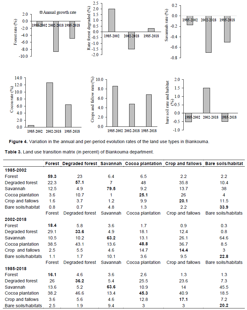
Between 1985 and 2018, land use in Biankouma underwent various changes. Forest area that occupied 34.7% (167930 ha) of the department in 1985 declined to 27.2% (131733 ha) in 2002 and then to 6.9% (33190 ha) in 2018 (Table 2). Over the study period, the department experienced an annual deforestation rate of 4.9% (Figure 4). Similarly, savannas, which covered 40.6% (196424 ha) of the department in 1985, occupied 39.4% (190754 ha) and 35% (169255 ha) respectively in 2002 and 2018. Between 1985 and 2018, the annual rate of savannah reduction was 0.5%. As for degraded forests, their surface area increased between 1985 and 2002 from 16.7% (80929 ha) to 23.7% (114591 ha), then decreased by 1.5% annually between 2002 and 2018. This class showed an annual increase of 0.3% between 1985 and 2018. In contrast to forests and savannahs, cocoa plantations, crop and fallows, bare soils and habitats increased in area between 1985 and 2018. Cocoa plantations, which occupied 3.7% (17774 ha) of the department in 1985, increased to 4% (19375 ha) in 2002 and then to 30.2% (146639 ha) in 2018, representing an annual growth rate of 6.4% between 1985 and 2018. This was also the case for the crops and fallows, which increased by 6.8% over the period under study. On the other hand the bare soils and habitats, initially recorded a decrease in area between 1985 and 2002 followed by an increase. It rose from 3.5% (17073 ha) in 2002 to 4.5% (21866 ha) in 2018, that is., an annual rate of increase of 1.5% between these two dates.
Transformation of land use in the Biankouma department
Land use transfer
Changes in the different land use classes between 1985 and 2018 in the Biankouma department are reported in Table 3. The values in the diagonal correspond to the rate of class stability during this period. From 1985 and 2018, the classes with the greatest stability are savannah and cocoa with 63.6 and 45.3% stability respectively. From 1985 to 2002, there was a low conversion of forest and savannah to cocoa plantations, that is. 3.6 and 1% respectively. During this period, 22.3% of forest and 48% of cocoa trees were converted into degraded forest. The period 2002-2018 is the period when the largest transfers of other classes to cocoa production are observed. During this period, 38.5% of forest, 43.1% of degraded forest, 13.6% of savannah and 36.7% of crops and fallow land were converted into cocoa plantations. Compared to savannah, forest was significantly considerably altered during this period. It is stable at 18.4% compared to 63.2% for the savannah. Compared to forest, savannah areas are less converted into cocoa plantations.
Dynamics of spatial structure
The determination of the dynamics of the spatial structure of the study area revealed that over the study periods (1985-2002 and 2002-2018), each of the land use classes was subjected to different processes. Between 1985-2002, the cocoa class experienced a decrease in the number of patches and an increase in the total area of patches (Table 4) resulting in a process of aggregation of cocoa patches. During this period, the forest, savannah and bare soil and habitat classes experienced an increase in the number of spots and a decrease in the total area of spots. These classes would be subject to dissection. On the other hand, the degraded forest and the mosaic of crops and fallow land experienced an increase in both the number of patches and the total area of patches between 1985-2002. Thus, the spatial transformation at the level for these classes is the creation of patches. Between 2002-2018, the cocoa and bare soil and habitat classes are experiencing an increase in both the number of patches and the total area of patches, resulting in the creation of patches. In contrast, during this period, the forest, degraded forest and savannah classes show a decrease in the number of patches and total area of patches, indicating a removal of their patches. At the level of the mosaic class of crops and fallow land from 2002 to 2018, there is an aggregation of patches corresponding to a decrease in the number of patches and an increase in the total area of patches.


Socio-demographic profile of cocoa producers
Origin of cocoa producers
Two hundred and seventy-five people were interviewed and 271 were males and with only four females. In general, female cocoa plantation owners inherited from their late husbands. Cocoa cultivation in the zone is carried out by migrants. In fact, 52% of the producers migrated to the zone for cocoa farming (Figure 5), while 48% of the producers interviewed were originally from the study zone.
Population settlement period
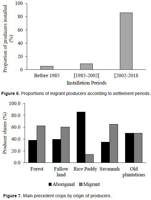
Three major producer installation periods were identified in the study area. The first period is prior to 1985, the second covers the 1985-2002, and the last covers the period 2002-2018 (Figure 6). Compared to the 2002-2018 period, the period before 1985 and the period from 1985 to 2002 represent the periods of low installation of migrant producers in the study area. Before 1985 and between 1985 and 2002 respectively, 5.4 and 9% of migrant producers settled in the study area. The period 2002-2018 is the period of high migration of producers in the zone with an installation rate of 85.5%.
Main cropping precedents of cocoa farms
The surveys revealed that plantations have been established on five (5) main cropping precedents : forest, fallow, rice field, savannah and old plantations (Figure 7). Migrant producers who have set up their cocoa farms in the forest and savannah are twice as numerous as indigenous producers. In fact, 62.1% of migrant producers compared to 37.9% of indigenous producers have their farms in the forest. Similarly, 65% of migrant producers compared to 35% of indigenous producers have their farms in the savannah. Indigenous producers (85.7%) prefer to set up their cocoa farms in previous rice fields. 60.4% of migrants have their cocoa farms in fallow land, compared with 39.6% of indigenous producers. Older plantations of perennial coffee crops are used equally by natives and migrants (50%).
Spatial and temporal dynamics of vegetation cover in western Côte d'Ivoire Vegetation cover in western Côte d'Ivoire through the case of Biankouma department has undergone a profound change under the influence of cocoa cultivation between 1985-2018. The forest and savannah that made up the matrix of the landscape were replaced by perennial crops represented mainly by cocoa plantations. This change has affected the forests (annual loss of 4.8% of the surface area) more than the savannah areas (0.5%) between 1985 and 2018. The 2002-2018 period experienced deforestation as significant in the Biankouma department with an annual rate of 8.6%. This annual deforestation rate is about four times that of Côte d'Ivoire and 17 times that of Africa, which are respectively 2.66% (Guizol et al., 2018) and 0.48% (MacDicken et al., 2016). During this time period, forest areas were converted mainly to cocoa production. This high rate of forest area as a precedent for cocoa cultivation could be attributed to the fact that forest provide optimal conditions for the growth of cocoa. Indeed, forest areas are the preferred areas for cocoa and coffee cultivation in Côte d'Ivoire (Koua, 2007). Moreover, deforestation is a settlement strategy that, through the occupation and development of land, gives ownership of this area to the one who cleared the land (Angelsen, 1999). Also, this conversion of forest areas (dense forest and degraded forest) into crops was highlighted by Freud et al. (2007) who reported that 89% of crops in Côte d'Ivoire are settled on primary and secondary forest clearings. The expantion of cocoa farming has been achieved in successive stages followinging the expansion dynamics of agricultural pioneer fronts (Brunet et al., 1996; Dubreuil et al., 2008). Indeed, between 1985 and 2002, there was an aggregation of cocoa tree patches, the creation of degraded forests and a cropping-crop mosaic while the forest and savannah underwent dissections. These spatial transformations of those land-use classes reflect the beginning of cocoa production cycle in this department. In practice, the rehabilitation of old cocoa farms and/or the conversion of old coffee fields leads to the aggregation of cocoa patches and the creation of annual crop-fallow mosaic patches. Both forest and savannah are infiltrated and the access roads are opened and maintained by the populations, hence the dissection. Cocoa-related disruptions consist in clearing the undergrowth prior for planting cocoa trees. The tall trees are not cut down, so seeing the canopy from above, one can think that the forest is in a good shape (Barima et al., 2016). This practice leads to the creation of patches of degraded forests.
The intense anthropisation of natural formations recorded between 2002-2018 in the department of Biankouma is due to the politico-military crisis that Côte d'Ivoire experienced in general from 2002 to 2011, and in the western part of the country in particular (Dabalen and Paul, 2014; N'Guessan et al., 2018). Indeed, armed conflicts have led to the abandonment of forest management, which, in addition to being areas of irregular logging and farming, are sometimes transformed into battlefields and refugee camps (Shuku, 2003).
According to Kouakou et al. (2018) and Barima et al. (2016), the crisis period in Côte d'Ivoire from 2006 to 2013 was the most disastrous for forest cover in the Centre-West of the country. In this region, forest degradation recorded between 1985 and 2018 did not only affect forests in rural areas but also those in protected areas. The research of Barima et al. (2016) reported the disappearance of nearly 70% of the forest cover in the classified forest of Haut-Sassandra in favour of cocoa cultivation during the decade of political crisis in Côte d'Ivoire. As compared to the forest areas in the study area, the savannas were less affected by cocoa farmers since they remained stable at 63.6% between 1985-2018. This situation can be accounted for the fact that savannas have long been considered unsuitable for cocoa farming, mainly due to the low density of woodland and the recurrent frequency of bush fires (Camara et al., 2009; 2012; Kouadio et al., 2013). Nevertheless, from 1985 to 2018, the savannah class was converted mainly into cocoa (13.4%), bare soil and habitat (9.4%) and crops and fallow (5.6%). This conversion of the savannah class is noticeable through a decrease in the number of patches and the total area of patches in this class. This situation resulted in a removal of patches in this class. The clearing of land in the savannah for the installation of cocoa plantations took place, while preserving the woody trees in the savannah. During the process of installing the cocoa tree, food crops and fruit trees are planted in the same year as well as the cocoa trees. The food crops limit the risk of fire that could destroy the cocoa plantations in the savannah while the fruit trees serve as shade (Camara et al., 2012). This spatial transformation of the savannah areas would be the consequence, over time, of the scarcity of forest land in the study zone. Such a situation would force farmers to give priority to the establishment of their cocoa plantations in the savannah. This attitude of farmers has already been observed in central Cameroon where, in the absence of forest land reserves, farmers have developed cocoa-based agroforests over large areas in savannah zones traditionally devoted to annual food crops (Camara et al., 2012). The matrix of the Biankouma department is currently dominated by cocoa production. This would indicate that agriculture would be the main factor inducing changes in land cover in western Côte d'Ivoire. This observation is similar to that reported across sub-Saharan Africa (Lambin et al., 2003; Wood et al., 2004; Avakoudjo et al., 2014).
Producer migration dynamics and land use change
In the process of spontaneous vegetation succession, the secondary forest phase occupies a central position. The secondary forests are indeed those that will reconstitute the dense forest (Bamba et al., 2008). They constitute the necessary passage to the climax state in a forest ecosystem (Toko et al., 2012). The decrease in their rate is a sign of disturbance for the restoration of the ecosystem (Toko et al., 2012). This decrease in the rate of secondary forest areas is due to an unsustainable practice of the agrarian system (Bamba et al., 2008) which leads to the discontinuation of the progress towars the forest. Generally speaking, this situation is caused by an increasing demographic pressure leading to a reduction in fallow times.
Three major periods of producer installation were identified in the study area: (1) before 1985, (2) from 1985 to 2002 and (3) between 2002 and 2018. The degradation of natural vegetation in general, and of the forest cover in particular, would be attributable to the massive arrival of migrants in this department. Indeed, according to the survey, 85.5% of migrant producers settled in the study area between 2002 and 2018. This period also coincided with the one over which there was an annual loss of 8.3 % of forest. In addition, over twice of the migrant producers settled their cocoa farms in forests and savannahs than indigenous producers. Hence, growing agricultural land to feed an ever-growing population could explain the reduction in the length of fallow periods and the annual extension of anthropised areas (Avakoudjo et al., 2011). Demography as a major factor in tropical deforestation is a reality and not a myth as suggested by the work of Lambin et al. (2001). Studies on the sustainability of farming methods often indicate that migrants have more destructive practices than indigenous farmers (Van Der Geest, 2010). This is because migrant farmers generally farm rented land and, considering their stay as temporary, would not be motivated to apply environmentally sustainable methods (Van Der Geest, 2010). Finally, as argued by Lambin et al. (2001), Assalé et al. (2016) and Zanh et al. (2019), migrants often do not have the same background knowledge on the local environment as natives, which can also lead to their environmentally unsustainable practices. For example, in the Centre-West of Côte d'Ivoire, cocoa producers are generally national migrants from Central Côte d'Ivoire and Burkina Faso (Zanh et al., 2016). The latter when establishing cocoa plantations almost systematically cut down all large trees (Barima et al., 2016; Kouakou et al., 2017b. In contrast, the indigenous farmers have a better backgroung knowledge of the uses and virtues of trees in their environment because they use these trees for various food, medicinal, artisanal and spiritual purposes (Kouakou et al., 2017a).
This study assessed the impact of population migration for cocoa cultivation on vegetation degradation in the mountainous West of Côte d’Ivoire. On the basis of analyses of remote sensing images and field observations, the results showed that the forest and savannah areas experienced a regression in surface area between 1985 and 2018. At the forest level, annual regression rates of 1.4 and 8.3% were observed between 1985 and 2002 and between 2002 and 2018, respectively. As for savannah areas, decreases of 0.2 and 0.7% were determined during these periods. These decreases in surface areas led to the dissection and removal of forest and savannah patches between 1985 and 2002 and between 2002 and 2018 respectively. On the other hand, cocoa farms are experiencing an aggregation and creation of patches following the expansion of orchards by farmers between 1985 and 2018. Thus, during this period, cocoa farming considerably alters the landscape of western Côte d'Ivoire. The period from 2002 to 2018, which corresponds to the period of strong migration in the zone, is equivalent to the period of strong anthropisation of the forests and savannah in the west of the country.
The authors have not declared any conflict of interests.
The authors appreciate the Academy of Arts, Cultures of Africa and African Diasporas (ASCAD) of Côte d'Ivoire for funding this research. This study is part of the project titled "Cocoa Expansion Dynamics and Impacts on Biodiversity and Food Security in Western Côte d'Ivoire", carried out by the Groupe de Recherche Interdisciplinaire en Ecologie du Paysage et Environnement (GRIEPE).
REFERENCES
|
Aké-Assi L (1998). Impact of logging and agricultural development on the conservation of biological biodiversity in Côte d'Ivoire. Le flamboyant 46:20-21.
|
|
|
|
Adou CY, N'Guessan EK (2006). Spontaneous floristic diversity of coffee and cocoa plantations in the classified forest of Monogaga, Ivory Coast. Schweizerische Zeitschrift fur Forstwesen 157(2):31-36.
Crossref
|
|
|
|
|
Angelsen A (1999). Agricultural expansion and deforestation : Modelling the impact of population, market forces and property rights. Journal of Development Economics 58:185-218.
Crossref
|
|
|
|
|
Assalé AAY, Barima YSS, Kouakou KA, Kouakou ATM, Bogaert J (2016). Agents of degradation of a protected area after a decade of conflict in Côte d'Ivoire: the case of the classified forest of Haut-Sassandra. International Journal of Innovation and Scientific Research 22: 123-133.
|
|
|
|
|
Avakoudjo J, Mama A, Toko I, Kindomihou V, Sinsin B (2014). Dynamics of land use in the W National Park and its periphery in north-west Benin. International Journal of Biological and Chemical Sciences 8(6):2608-2625.
Crossref
|
|
|
|
|
Avakoudjo J, Kindomihou V, Sinsin B (2011). Farmers' perception and response to soil erosion while abiotic factors are the driving forces in Sudanian Zone of Benin. Agricultural Engineering Research Journal 1(2):20-30.
|
|
|
|
|
Aubréville A (1957). Yangambi Agreement on the nomenclature of African types of vegetation. Tropical Woods and Forests 51(51):23-27.
|
|
|
|
|
Ba I (2015). The General Census of Population and Housing of Côte results. Abidjan: National Institute of Statistics d'Ivoire in 2014. Execution report and presentation of the main
View
|
|
|
|
|
Balac R (2001). Migration dynamics and plantation economy. Côte d'Ivoire at the dawn of the 21st century. Défis démographiques et développement durable, Paris, Karthala pp. 195-231.
|
|
|
|
|
Bamba I, Barima YSS, Bogaert J (2010). Influence of population density on the spatial structure of a forest landscape in the Congo Basin in DR Congo. Tropical Conservation Science 3(1):31-44.
Crossref
|
|
|
|
|
Bamba I, Mama A, Neuba DF, Koffi KJ, Traore D, Visser M, Bogaert J (2008). Influence of anthropogenic actions on the spatio-temporal dynamics of land use in the Bas-Congo province (DR Congo). Sciences and Nature 5(1):49-60.
Crossref
|
|
|
|
|
Barima YSS, Kouakou ATM, Bamba I, Sangne YC, Godron M, Andrieu J, Bogaert J (2016). Cocoa crops are destroying the forest reserves of the classified forest of HautSassandra (Ivory Coast). Global Ecology and Conservation 8:85-98.
Crossref
|
|
|
|
|
Bidou JE, Droy I, Houesse R, Mering C (2019). Population dynamics, vulnerability and changes in vegetation cover in northern Benin:comple x interactions. Espace Populations Sociétés. Space populations societies.
Crossref
|
|
|
|
|
Bogaert J, Ceulemans R, Salvador-Van Eysenrode D (2004). Decision tree algorithm for detection of spatial processes in landscape transformation. Environmental Management 33(1):62-73.
Crossref
|
|
|
|
|
Brou YT, Chaléard JL (2007). Farmers' Visions and Environmental Change in Côte d'Ivoire. Annals of Geography 653:65-87.
Crossref
|
|
|
|
|
Brunet R, Ferras R, Théry H (1996). Les Mots de la géographie. Critical dictionary. Paris/Montpellier: French documentation/RECLUS, "spatial dynamics" collection 520 p.
|
|
|
|
|
Camara AA, Dugué P, Foresta HD (2012). Transformation of forest-savanna mosaics through agroforestry practices in sub-Saharan Africa (Guinea and Cameroon). Cybergeo : European Journal of Geography, Environment, Nature, Landscape.
Crossref
|
|
|
|
|
Camara A, Dugué P, Cheylan JP, Kalms JM (2009). From natural forest to agroforests in Forest Guinea. Cahiers agricultures 18(5):425-432.
Crossref
|
|
|
|
|
Dabalen AL, Paul S (2014). Effect of conflict on dietary diversity : Evidence from Côte d'Ivoire. World Development 58:143-158.
Crossref
|
|
|
|
|
Desdoigts A, Kouadio HK (2013). Deforestation, migration, land appropriation and reforms : resilience of rural areas in the context of the Malthusian crisis in Côte d'Ivoire. Érudit.
|
|
|
|
|
Dubois E, Michaux E (2006). Benchmarking with business surveys : new results. Economics and Forecasting 1:11-28.
Crossref
|
|
|
|
|
Dubreuil V, Laques AÉ, Nédélec V, Arvor D, Gurgel H (2008). Landscapes and pioneering Amazonian fronts under the gaze of satellites: the example of Mato Grosso. L'espace géographique 37(1):57-74.
Crossref
|
|
|
|
|
Ferraton N, Touzard I (2009). Understanding family farming : diagnosis of production systems. Edition Quae, CTA, Agronomic Press of Gembloux 135 p.
|
|
|
|
|
Fairhead J, Leach M (1998). Reframing Deforestation : global analyses and local realities -Study in West Africa. Routledge, Global Environemental series, London (England) 238 p.
|
|
|
|
|
Guizol P, Roda JM, Brou JMP, Daubrey M (2018). Diagnostic study for the promotion and strengthening of the sustainable wood value chain in the framework of REDD+ in Côte d'Ivoire. Synthetic report. 32 p.
|
|
|
|
|
Forman RTT (1995). Land Mosaics : the ecology of landscapes and regions. Cambridge University Press, Cambridge, UK.
Crossref
|
|
|
|
|
Freud EH, Petithugenin P, Richard J (2007). Cocoa fields : a challenge for African-Asian competitiveness. Paris : Karthala 117 p.
|
|
|
|
|
Hervé D, Ratiarson V, Ramamonjisoa BO (2015). Scenarios of forest cover decrease according to demographic pressure and agricultural intensification. Transitions agraires pp. 221-232.
|
|
|
|
|
Koné M (2015). Evolution of dense forest cover and impact of deforestation on the migration of the cocoa loop in Côte d'Ivoire. PhD thesis in natural science, UFR sciences de la nature, Université Nangui Abrogoua, Abidjan (Côte d'Ivoire) 156 p.
|
|
|
|
|
Koua A (2007). Situation of coffee production in Côte d'Ivoire: the case of the department of Aboisso. Engineer thesis, Higher School of Agronomy, National Polytechnic Institute Houphouët Boigny, Yamoussoukro, Côte d'Ivoire, 90p.
View [Accessed 21.3. 2018].
|
|
|
|
|
Kouakou KA, Barima YSS, Kouakou ATM, Sangne YC, Bamba I, Kouamé NF (2015). Post-conflict plant diversity in the Haut-Sassandra Classified Forest (Center-Western Côte d'Ivoire). Journal of Animal & Plant Sciences 26(2):4058-4071.
|
|
|
|
|
Kouadio KB, N'Da DH, Vroh BTA, Zobi IC, N'Guessan KE (2013). Vegetation dynamics and bush fire frequency in the Abokouamekro Wildlife Reserve (Centre, Côte d'Ivoire). European Scientific Journal 9(35):179-192.
|
|
|
|
|
Kouadjo JM, Keho Y, Mosso R.A, Toutou KG, Nkamleu GB, Gockowski J (2002). Production and supply of cocoa and coffee in Côte d'Ivoire. Investigation Report 128 p.
|
|
|
|
|
Kouakou ATM, Assalé AAY, Barima YSS (2018). Impact of anthropic pressures on the flora of the classified forest of Haut-Sassandra (Centre-West of Côte d'Ivoire). Tropicultura 36(2):155-170.
|
|
|
|
|
Kouamé NP (2014). Contribution of satellite imagery to the early detection of crops under forest cover in protected areas subject to anthropic pressures: case of cocoa production in the Mont Sangbé National Park in western Côte d'Ivoire. Master's thesis, CURAT, Félix Houphouët-Boigny University, Côte d'Ivoire 61 p.
|
|
|
|
|
Kouakou KA, Barima YSS, Zanh GG, Traoré K, Bogaert J (2017a). Inventory and availability of non-timber forest products used by the riparian populations of the Haut-Sassandra Classified Forest after the period of armed conflict in Côte d'lvoire. Tropicultura 35(2):121-136.
|
|
|
|
|
Kouakou ATM, Barima YSS, Konaté S, Bamba I, Kouadio YJ, Bogaert J (2017b). Gestion des forêts domaniales en période de conflits : cas de la forêt classée duHaut-Sassandra, Centre-Ouest de la Côte d'Ivoire. International Journal of Biological and Chemical Sciences 11(1):333-349.
Crossref
|
|
|
|
|
Lambin EF, Geist HJ, Lepers E (2003). Dynamics of land-use and land-cover change in tropical regions. Annual Review of Environment and Resources 28:205-241.
Crossref
|
|
|
|
|
Lambin EF, Turner BL, Geist HJ, Agbola SB, Angelsen A, Bruce JW, George P (2001). The causes of land-use and land-cover change : moving beyond the myths. Global Environmental Change 11(4):261-269.
Crossref
|
|
|
|
|
Landis JR, Koch GG (1977). The measurement of observer agreement for categorical data. Biometrics 33:159-174.
Crossref
|
|
|
|
|
MacDicken K, Jonsson Ö, Piña L, Maulo S, Contessa V, Adikari Y, Garzuglia M, Lindquist E, Reams G, D'Annunzio R (2016). Global Forest Resources Assessment 2015 : How are the world's forests changing?
View
|
|
|
|
|
N'Da DH, N'Guessan KE, Wadja EM, Kouadio A (2008). Contribution of remote sensing to the monitoring of deforestation in the Marahoué National Park (Côte d'Ivoire). Remote Sensing 8(1):17-34.
|
|
|
|
|
N'Guessan KG, Oura KR, Loba ADFV (2018). Political crisis, land pressure and food security in the periphery of the Mount Peko classified forest. Tropicultura 36(2):356-368.
|
|
|
|
|
Picouet M, Boissau S, Brun B, Romagny B, Rossi G, Sghaïer M, Weber J (2004). The renewal of population-environment theories pp. 17-43.
|
|
|
|
|
Puyravaud JP (2003). Standardizing the calculation of the annual rate of deforestation. Forest ecology and management 177(1-3):593-596.
Crossref
|
|
|
|
|
Ruf F, Schroth G (2004). Chocolate Forests and Monocultures : A Historical Review of Cocoa Growing and Its Conflicting Role in Tropical Deforestation and Forest Conservation. In Agroforestry and Biodiversity Conservation in Tropical Landscapes. Island Press, 1718 Connecticut Avenue, N.W., Suite 300, Washington DC (USA) pp. 107-134.
|
|
|
|
|
Schlaepfer R (2002). Analysis of landscape dynamics. information document 4.2, Ecosystem Management Laboratory, Ecole Polytechnique de Lausanne, Switzerland. 10 p.
|
|
|
|
|
Shuku O (2003). Environmental Assessment of Armed Conflict : The Case of the DRC. Communication, Marrakech, Morocco 5 p.
|
|
|
|
|
Tano AM (2012). Cocoa crisis and strategies of producers in the sub-prefecture of Méadji in south-west Côte d'Ivoire. PhD thesis. UMR Rural Dynamics. University of Toulouse, France 239 p.
|
|
|
|
|
Toko MI, Toko II, Sinsin B, Touré F (2012). Indices of spatial structure of dense forest islands in the Monts Kouffé region. Vertigo 12(3):17.
|
|
|
|
|
Van der Geest K (2010). Ghana, Agricultural migration and sustainable land use in the forest-savanna transition zone. People and Migration. French Reference Journal on Migration Dynamics 1284:112-127.
Crossref
|
|
|
|
|
Varlet F, Kouamé G (2013). Study of cocoa production in the riparian zone of the Taï National Park. Rural Economic Development Program (PRODEMIR), GIZ 184 p.
|
|
|
|
|
Wood EC, Tappan GG, Hadj A (2004). Understanding the drivers of agricultural land use change in south-central Senegal. Journal of Arid Environment 59:565-582.
Crossref
|
|
|
|
|
Zanh GG, Kpangui KB, Barima YSS, Bogaert J (2019). Migration and Agricultural Practices in the Peripheral Areas of Côte d'Ivoire State-Owned Forests. Sustainability 11(22):63-78.
Crossref
|
|
|
|
|
Zanh GG, Barima YSS, Kouakou KA, Sangne YC (2016). Uses of non-timber forest products according to the riparian communities of the classified forest of Haut-Sassandra (Centre-West of Côte d'Ivoire). International. Journal Pure Applied Bioscience 4(5):212-225.
|
|