Review

ABSTRACT
The focus of this paper is on new town building in hydro drought regions. It looks at new town building from the sustainability perspective; especially it discusses the supply and distribution of water in the new towns. The aim of this paper is to resolve a dilemma in the arid regions. One side a much demand for new towns because of the population growth and other side the water anxiety is being a key reason hindering the urban development. Methodological approaches of this paper is to supply some volumes of the required water for a new town in the south of Iran called for Ramshar with the help of intense and devastating, but rare regional rains. The aim is to supply water from the rains and store it in a covered lake near Ramshar. This paper conducts a case study to find the reasons of depletion of the regional water resources, to apply the hydraulic routing method, to make the storage, and to use the water according to a hydrosocial change balance program timely. This paper suggests the practical model to supply water before every new town building. The model is a supportive and feasible tool to overcome the serious dilemma everywhere similar Ramshar
Key words: New town, water resources, sustainable development, drought, flood routing, hydro social change balance.
INTRODUCTION
Harmonious urban water supplying and building of new towns
The growing need for new towns in Iran comes from rapid increasing of the population (Mohajeri et al., 2014) and (Abdoli et al., 2014). The recent history of new town making in Iran passes a way that is very dissimilar to the way, which it should go. Now days in the dry and semi-arid climates, people need water for drinking, industrial needs, and agricultural uses to supply food, hygiene, and living requisites at least acceptable standard. This paper similar major scholars understands that new towns are necessary for Iran, but there is not enough water to build new towns (Shahraki, 2014). So, this paper is to give natural water resources beforehand the process of planning, designing, and building of new towns. The current custom is to build new towns after demanding and the pressures of the desperate people. The present style does not include pre-studies to find out suitable sites with necessary natural resources and water assets for a new town so that Klinken et al. (2012), Tsinda et al. (2015), Nhapi (2015), Broto et al. (2015), Wray and Cheruiyot (2015) and Davies (2015) argued that for the rapidly expanding and unplanned settlements and towns, water service provision presents a different challenge. At the present, Iran builds new towns without ensuring of the necessary water resources and with no planning of essential water supply infrastructure and distribution networks, that is Hakiminejad et al. (2015) and Yazdani et al. (2014). Therefore, people are not willing to live in the new towns, the new towns are vulnerable, and they are not sustainable.
This paper focuses on the need for provision of water resources before the process of planning, designing, and building of a new town. It highlights the need for management of likely water resources while Morris (2007) suggested to plan and to manage with respect to the local particularities:"The issues that should be examined in a water resource management plan necessarily vary with the nature of the area and its water management problems" (Morris et al., 2007:4).
As has been said housing and new town building projects in central and southern parts of Iran faced with the non-existing of needed water resources and so they are not sustainable. How shall Iran plan, design and built a new town to meet the needs of its inhabitants and sustainable result? After six decades of the new town buildings, the question still exists. The new towns of Iran in the southeast part of the country have more and less the condition, that Tomasella illustrated for Amazona area:"Drought, fire and their interactions play an important role in the carbon dynamics, vegetation–atmosphere interactions, hydrology, and health of Amazon ecosystems, and in the livelihoods of Amazon residents" (Mareng et al., 2008:1775). The regional inhabitants are damaging the built environments with ignoring the feasibility studies, natural resource analysis, and none understanding of the sites of the new towns. Worse, the municipal organizations and management bodies are unable to give the necessary knowledge and skills so that they did not meet their targets (Shahraki, 2014).
In essence, our problem now is a two facial problem. From one side the growing regional people are demanding more urban neighborhoods and from the other side the increasing population damages the natural water resources. This two facial problem has been deepened by the time passing and has reached at a serious level now. At the present, Iran must plan, design, and build new towns and supply water resources for urban consumption simultaneously. In fact, no room to lower the importance of planning water infrastructure including water supply, water distribution, and building of water reservoirs in the first step of the new urban planning, designing and building process. Therefore, the problem has a natural dimension when the region experiences drought and less precipitation so that the available water volume is short indeed (Klare, 2015; Gorelick and Zheng, 2015; Mahmoud et al., 2015). In fact, the out way is to control seasonal floods, to collect and gather the obtained water from possible catchments and use them in the new towns.
This study aims to introduce the main roots of the degrading of the water resources, which hinder the building of the new towns, and to suggest a practical model for new town planning, designing, and building. The model includes the provision of needed water. So, this paper is going to present a model for reserving the needed urban water and building of the new towns simultaneously. It encourages the urban developers to revise their current work method and to supply a part of urban water from the sudden and destructive floods before building of any new town in the region.
The hypothesis of this paper is on the fact that new towns without supplying of needed water resources will disable to settle the people successfully. It presumes that in practice a successful systematic planning, designing and building model requires simultaneous attempts to give the water resources and to build the new towns. This paper believes that the comprehensive plan of every new town should trust on realization of provision of the needed water resources, water supply infrastructures, water distribution networks, and urban water management programs. In the other word the water anxiety shall be addressed before any finalization of the new town building plan.
This research uses both theoretical and laboratory methods. It reviews the literature on the natural resources, water resources, drought that degrades the water resources, water supply and reserving, new town building and link between the constructing and needed water resources. The laboratory method of this paper is the strategy of a case study implementation. It analyzes the case of the new town of Ramshar by help of field observation and direct seeing and feeling of the problems.
To set up a real model for planning, designing and building of the new town of Ramshar this paper used practical hydraulic engineering rules to first supply urban required water for the new town of Ramshar and then to distribute the collected and stored water among the urban consumers for various needs. Ramshar has neither surface water nor ground water therefore; the method of hydraulic flood routing has been selected to predict the harmful floods with the help of the hydro graph technique aiming to calculate the volume of likely available water. It had to predict the floods and then route the flood basin aiming to gather the sudden huge volume of waters into a storage lake and to use according to a hydro social change balance program. Since the region rarely experience seasonal sharp short standing, but destructive rain falls and floods the technical methods shall be suitable for the particular features of Ramshar.
WATER SCARCITY IN THE MIRROR OF THE LITERATURE
Awareness of hydrological conditions in each region can help to optimal planning for required water resources and water management (Valipour, 2013) suggested a Surface water supply index (SWSI). The index is one of the most important hydrologic parameters for study of drought and flood periods in basins. Author has used SWSI in Colorado and Oregon in United States. The study has shown that population growth is a significant indicator.
Population growth parallel to degradation of natural resources forced today’s urban planners to focus on sustainable development, particularly in developing countries. Ho (2007) defines sustainable urban development as: "Sustainable urban development improves the long-term social and ecological health of cities and towns" (Ho, 2007:16). Many scholars and experts argue that modern lifestyles and distance from a natural life use too many natural resources. They argue that the current lifestyle causes much polluting and destroys the ecosystems. They resulted that continuation of the present trend causes climate changes. The scholars in the fields of urban and regional planning and natural sciences, that is, Barbosa and Villagra suggest changing the current wrong trend (Barbosa and Villaga, 2015). The building of new towns links with the sharp growth in population numbers and huge demands for homes. While the new town building requires adequate water resources, the world concerns with water resources as Merret (2002) wrote “In addition to the increase in the world’s population in the early years of the new millennium there is a second source of anxiety about the future availability of global water resources for people” (Merret, 2002).
Shahraki (2014) described that during the recent six decades the demands to new towns were the result of the growth of the urban areas and metropolises. In Iran, new towns' projects were usually associated with the idea of management of population and solving of immediate urban problems like demand for homes, the need for other urban spaces, anarchical traffic regimes, and pollution. Therefore, the planning process for new towns was not integrated with the idea of sustainability and experiences prove that they did not meet the targets. Housing and town building projects are still going in wrong directions. Owing to the price of the water resources to plan, design and build a new town the developers shall understand natural and human made roots of the water depletion in the regions. The degradation of natural resources and disappearing of water resources in Iran is an important obstacle to build new towns. To react the impact of the climate change and natural hardness (Hossain et al., 2015; Ball, 2015; Beach et al. 2015; Collard et al., 2015) and many other scholars have been suggesting less water use. The recommendation of the scholars is understandable particularly when drought is the biggest problem in the way of sustainable building so the new towns shall use less water as much as possible.
Major scientists in climate studies, that is, Mullin and Rubado (2015) and Basher et al. (2015) believe that drought persists for several years; even a short intense drought can cause significant damages and harm the local people and their lives. Drought degrades the quality of existing water resources. It depletes the water resources in the drought regions, stops the new town building, and causes a dangerous water crisis. Understanding the reasons of drought suggests that the drought accelerates still the rapid growth of population. The growth undoubtedly has direct consequences for the environment.
Poverty is a significant reason of the drought. There is obvious how desperate is the national finances in poorer regions. To analyze the reasons of the drought in Sistan plain first the need for Helmand water in the two neighboring countries shall be named. Though, the rush of farm workers to big cities and bankruptcy of farms contributed to the drought. The drought remained the following impact on natural resources of the Ramshar region:
1. Erosion of lands and soils
2. Disappearing of surface water resources and falling the level of water in wells and underground resources.
3. Agricultural drought in the region as transforming of farms into sand dunes
4. Disappearing of surface vegetation and plants
5. Creation of brutal hazarding storms of sand dunes
6. Socioeconomic results poverty.
There is evidence to suggest that drought in the region is continuing to accelerate. A number of scholar uses the term of “catastrophe” as Mojtahedzadeh (2001) wrote Hamoon lake catastrophe, the most similar to Oral lake catastrophe. Generally, the drought damages natural resources. Natural resource degradation is the most dangerous enemy of the access to water for the population in these regions.
Drought is experienced as a period with rainfall below the average or on the other word with evaporation many times more than precipitation (Johnson and Sharma, 2015). Arid and semiarid environments have the special characteristics which the developers shall understand before any new town building in the regions. Rainfall in the region is not regular and it is sparse and rarely strongly pulsed (de Jode, 2015). Since regional people do not have the technologies and infrastructure to save the precipitation and use it timely such rainfalls are caustic. The task of planning, designing, and building of new towns in the regions first requires methods to hinder the ongoing degradations of water resources and to supply new water from the said floods.
THE REGIONAL NEW TOWNS IN THE MIRROR OF PRACTICE, THE CASE STUDY
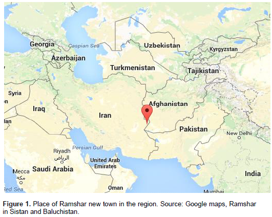
The new town of Ramshar has been planned two decades ago. It is one of the most obvious unsuccessful cases in sustainability. Apart managerial reason the failure has the fundamental classical planning problems. This observation introduces the problem of water depletion as a main hinder to develop the new town of Ramshar. Since Ramshar is close to border of three countries Iran, Afghanistan, and Pakistan, it has an international position. Ramshar is 40 km south of Zabol city, along the Zabol-Zahedan road in Sistan plain. Sistan is the continuation of Helmand river basin mainly in Afghanistan. Figure 1 shows red marked the position of Ramshar in Iran.
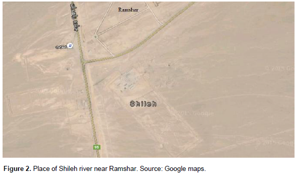
A 1000 ha land on the Sistan plain is to make the new town of Ramshar. The target was to settle 70000 people in Ramshar, but it failed. Ramshar as an arid region has not much precipitation. For climatic perspective, Ramshar is in an arid region and it has a desert climate with a hot and dry weather and no place for rains. Therefore, this study shall not count on the regular and normal precipitation. However, arid climates have the special characteristics; rainfall is sparse, rarely strongly pulsed, and unpredictable. Ramshar shall supply required technologies and infrastructure to save the precipitation and use it timely. Ministry of housing and town building has calculated the necessary water volume for supposed 70000 inhabitants per year (Table 1).
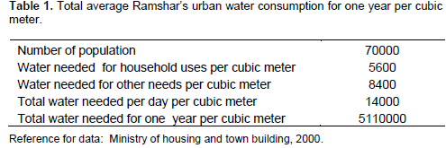
Since Ramshar’s climate is arid, every person needs 200 L per day, of which 40% for household uses and 60% for other needs. Thus, Ramshar needs ![]() L water per day and 5110000 cubic meters per one year. To develop the new town of Ramshar hydraulic knowledge of the area is necessary at two stages. The first stage is planning when the general plan of Ramshar is being decided. Estimations of the discharge hydrographs on the natural watercourses and computation of possible water resources shall be done during this phase. The second stage is selection of details such as designing of the storm water channels and pipes to carry the water to consumers. The region has a gigantic, sensitive and complicated hydraulic system that includes three parts:
L water per day and 5110000 cubic meters per one year. To develop the new town of Ramshar hydraulic knowledge of the area is necessary at two stages. The first stage is planning when the general plan of Ramshar is being decided. Estimations of the discharge hydrographs on the natural watercourses and computation of possible water resources shall be done during this phase. The second stage is selection of details such as designing of the storm water channels and pipes to carry the water to consumers. The region has a gigantic, sensitive and complicated hydraulic system that includes three parts:
1. Helmand/Hirmand River as a water importing river to the plain- The name of Helmand in Iran is Hirmand. It originates from the western edge of the Hindukoosh Mountain that ranges 40 km west of Kabul. The Helmand takes the course of southwest direction and gathers several tributaries. It ends at the border of Iran and spills into the lake of Hamoon. The total length of the river is 1050 km and the catchment area is 370000 km2. The Helmand river system feeds mainly snow and rain falling on the mountain of the upper reaches.
2. Hamoon Lake- Hamoon Lake with its sweet and qualified water was the most important lake in the region. Satellite photos proved that the lake occupied an area of 520000 ha during the water full periods. During the dry periods, it declines considerably down to 120000 ha. During the dry times Hamoon was separated into three parts; Poozak Hamoon, Saberi Hamoon and Hirmand Hamoon. Usually the level of Hamoon water began to rise from February gradually and reached to its greatest level in the June. The changes were directly connected to the volume of Hirmand importing water. Unfortunately, at the present time the lake is dry, and it has been transferred to a source for sand dune storms and many environmental hazards.
3. Overflowing water from Hamoon Lake into the Shieh- In water full-time, floods and overflowing water come to the Hamoon and then to the Shileh Shileh locates south of Hamoon and acts as a spillway and a main drainage. This seasonal and usually dry river is 100 kilometers long and ends to Afghanistan territory. The water that passes from Shileh during a flood is significant for planning water storage and water infrastructure network in Ramshar. The overflowing water volume is between two billion up to 15 billion cubic meters (Ministry of housing and town building, 2000). Again, this study acknowledged that the first priority of new town planning, designing, and constructing is the water supplying. The field observation suggests that every new town shall think on the irregularities in regional rains. Therefore, controlling of floods and collecting of the sudden rains are essential. This case study understood that the basic water resource in the region is the rarely floods when the Helamnd flow is blocked normally. In addition, this case study is suggesting planning and building a hydraulic construction in the shape of a huge covered lake to protect future stored waters from hot sun shines and evaporations. This case study also found out the best place for the water reservoir is on the bed of Shileh in south of Ramshar and alongside of the Zabol-Zahedan road as illustrated in the following map.
MODEL OF SUSTAINABLE NEW TOWN BUILDING WITH HYDRO SOCIAL CHANGE BALANCE PROGRAM, MSNHP
As has been said earlier the major water resource in the region was the Helmand River traditionally. Since Helmand originates in Afghanistan and owing to an international dispute on its water Ramshar shall supply water in the place. A major technique to supply needed urban water in an arid region with none underground resources is to forecast the irregular sharp floods. A common problem facing in practice is the estimation of the rise of Shileh River at any given point in the stream during the course of a flood event. This study has resolved the problem with the help of the technique of flood routing while it pursued the behavior of a flood hydrograph from the upstream point to downstream point. Eleven stations with one kilometer distance of each other were observed. During the famous hazardous 1993’s flood the water volumes were calculated at the eleven stations with the help of direct measurements. According to Figure 2, station 1 was at a point parallel to Ramshar and Station 11 with eleven kilometers distance was on the bed of Shileh. Table 2 reports the volume of water at eleven stations for upstream and downstream positions:
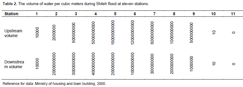
Using the data in Table 2 it was possible to sketch a flood hydrograph for Shileh as the flood water flowed downstream into the desert area southeast of Ramshar. In the hydrograph first, the time of the peak rate of flow occurred upstream at station 1 known as translation. Second, the size of the peak rate of flow at the downstream point went down at point 11, which was in south of Ramshar on the bed of Shileh known as attenuation there the shape of hydrograph flattened out. With the help of classic continuation equations the volume of supplied water has been calculated.
This study applied also the hydro social change balance program for Ramshar to manage the supplied water by the flood routing technique. It has been used for a five-year period. Table 3 as every generic form has both supply and use categories sides. The table reports the data for a defined interval time, 2010-2015.
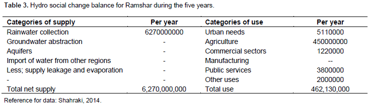
Calculating of the total volume of rainwater collection item is possible by the direct engineering gauging during the flood time. Other categories of supply have been ignored owing to none existence. The calculation verified that the total net supply is approximately 6270 billion cubic meters much more than the total use side almost 462 billion cubic meters. The analysis proved that the flood routing technique and the covered lake are going to be helpful and feasible. The hydro social change balance presented by this model helps to decide the quantitative and qualitative features of the hydraulic reservoirs that Ramshar needs. By this model, Ramshar can collect the floodwater and use it in its water management program. At a time when none other resource exists investment in this model can provide Ramshar needed water.
CONCLUSION
This paper discussed a paradoxical problem that while the number of the population was growing continuously the devastation of natural resource has prevented the building of new towns. This paper proved that the dilemma originated from climate changes, natural hazards, environmental catastrophes, poor management, and failures of new town programs. The study understood the depletion of water resources as the main problem for urban developments. This paper illustrated the situation that from one side the earlier built cities concern on the needed water and experience non-sustainable and from the other side no water to build new neighborhoods and new towns. Therefore, this paper understood that the building of new towns or expanding of existing urban areas in the present condition should include provision of water resources in its job. The case study of this paper observed the new town of Ramshar in an arid climate and saw that the volume of rainfall and available water was much less than the new town needed. Therefore, strategies, innovative projects and investments to overcome the problem of water in the region are needed. Programs such as control of population growth and family planning, increase of environmental awareness, regulation of natural resource use and international collaborations are helpful. This paper suggested a new possibility to supply the needed water by floodwaters. The case study proved that the flood routing technique is a possible procedure to control the seasonal sharp floods and to store huge volumes of water. Then, the hydro social change balance technique manages the gathered water to use it timely. This paper presented the Model of Sustainable New town building by Hydro social change balance Program, MSNHP. The model sets the water supply in the earliest step of a new town building process. The MSNHP depends very much on the nature of the problem, the data available, local characteristics, and general necessities. The MSNHP will revise and progress the current failed trend of the regional new town buildings towards sustainable, planned and successful developments.
CONFLICT OF INTEREST
The authors have not declared any conflict of interest.
REFERENCES
|
Abdoli A, Mohammadi J, Ghalibaf MB, Mousavi SMP (2014). Urban Development of zone22 of Tehran's Municipality toward Smart Growth Strategy. Environ. Manag. Sustain. Dev. 3(1):61-73. |
|
|
Ball P (2015). H2O: A biography of water. Hachette UK. |
|
|
Barbosa O, Villagra P (2015). Socio-ecological studies in urban and rural ecosystems in Chile. In Earth Stewardship pp. 297-311. Springer International Publishing. |
|
|
Basher R, Bronwyn H, Allan L, Alberto M, Omar P, Roger P, Ester S, Alik IZ, Susan C (2015). Disaster Risks Research and Assessment to Promote Risk Reduction and Management. |
|
|
Beach T, Luzzadder-Beach S, Flood J, Houston S, Garrison TG, Román E, Doyle J (2015). A Neighborly View: Water and Environmental History of the El Zotz Region. Tikal: Paleoecology of an Ancient Maya City P 258. |
|
|
Broto VC, Boyd E, Ensor J (2015). Participatory urban planning for climate change adaptation in coastal cities: lessons from a pilot experience in Maputo, Mozambique. Curr. Opin. Environ. Sustain. 13:11-18. |
|
|
Collard M, Rastrick SP, Calosi P, Demolder Y, Dille J, Findlay HS, Dubois P (2015). The impact of ocean acidification and warming on the skeletal mechanical properties of the sea urchin Paracentrotus lividus from laboratory and field observations. ICES J. Marine Sci.: Journal du Conseil, fsv018. |
|
|
Davies WK (2015). Healthy Cities: Old and New Solutions. Solutions for Urban Problems Springer Netherlands. pp. 477-531. |
|
|
de Jode H (Ed.), (2015). Valuing variability: New Perspectives on climate resilient drylands development. for educational or. |
|
|
Google map. |
|
|
Gorelick SM, Zheng C (2015). Global change and the groundwater management challenge. Water Resour. Res. |
|
|
Hakiminejad A, Fu C, Titkanlou HM (2015). A critical review of sustainable built environment development in Iran. Proc. ICE-Eng. Sustain. 168(3):105-119. |
|
|
Hossain MM, Kibria G, Nugegoda D, Lau TC, Wu R (2015). A Training Manual for Assessing Pollution (trace/heavy metals) in Rivers, Estuaries and Coastal waters-Using Innovative "Artificial Mussel (AM) Technology"-Bangladesh Model. Research collaboration between scientists of the IMSF, University of Chittagong, Bangladesh. |
|
|
Ho CS (2007). Towards a sustainable society from the perspective of energy conservation and urban structure. |
|
|
Johnson F, Sharma A (2015). What are the impacts of bias correction on future drought projections?. J. Hydrol. 525:472-485. |
|
|
Klare MT (2015). Climate Change Blowback: The Threats to Energy Security. SAIS Rev. Int. Affairs 35(1):61-72. |
|
|
Klinken R, Murray JV, Stokes KE (2012). Sustainable water services and the poor in small towns. Published by the East and Southern Africa office (ESA) of SNV Netherlands Development Organization. |
|
|
Mahmoud SH, Adamowski J, Alazba AA, El-Gindy AM (2015). Rainwater harvesting for the management of agricultural droughts in arid and semi-arid regions. Paddy Water Environ. pp. 1-16. |
|
|
Marengo JA, Nobre CA, Tomasella J, Cardoso MF, Oyama MD (2008). |
|
|
Hydro-climatic and ecological behaviour of the drought of Amazonia in 2005. Philosophical Transactions of the Royal Society B: Biol. Sci. 363(1498):1773-1778. |
|
|
Merret S (2002). Water for agriculture, Spon Press, London, ISBN 0-415-52238-5 |
|
|
Ministry of housing and town building (2000). Regional physical/spatial plans. Water uses and resources. Published in Farsi in Tehran. |
|
|
Mojtahedzadeh P (2001). Hamoon lake catastrophe", Social monthly magazine, Osveh, no. 1, Iran. |
|
|
Mohajeri N, Poursistany P, Poursistany P, Gudmundsson A (2014). Quantitative Analysis of Structural Changes during Rapid Urban Growth: Case Study of Kerman, Iran. J. Urban Planning Dev. 05014014. |
|
|
Morris M, Glenn H, Dave D, Claire B, Joe D, Eric W, Ronald L (2007). Water Resource Management Planning. Published by Massachusetts office of energy and environmental affairs. USA. P 4. |
|
|
Mullin M, Rubado ME (2015). Local Response to Water Crisis: Explaining Variation in Usage Restrictions during a Texas Drought. |
|
|
Nhapi I (2015). Challenges for water supply and sanitation in developing countries: case studies from Zimbabwe. In Understanding and Managing Urban Water in Transition Springer Netherlands pp. 91-119. |
|
|
Shahraki AA (2014). Sustainable new towns in Iran: Reflections on problems and practices of urban planning and design using case studies. |
|
|
Tsinda A, Abbott P, Chenoweth J (2015). Sanitation markets in urban informal settlements of East Africa. Habitat Int. 49:21-29. |
|
|
Valipour M (2013). Use of surface water supply index to assessing of water resources management in Colorado and Oregon, US. |
|
|
Wray C, Cheruiyot K (2015). Key Challenges and Potential Urban Modelling Opportunities in South Africa, with Specific Reference to the Gauteng City-Region. South Afr. J. Geomatics 4(1):14-35. |
|
|
Yazdani S, Dola K, Azizi MM, Yusof JM (2014). Challenges of Coordination in Provision of Urban Infrastructure for New Residential Areas: The Iranian Experience. Environ. Manag. Sustain. Dev. 4(1):48-72. |
|
Copyright © 2024 Author(s) retain the copyright of this article.
This article is published under the terms of the Creative Commons Attribution License 4.0


