ABSTRACT
A key to future sustenance of human societies lies in the sustainable management and wise use of Wetlands. Wetlands are frequently referred to as Kidneys of Landscape; are amongst the most productive ecosystems on the earth and any alterations might lead to changes in their bio-physical, socio-economic and climatic conditions. Due to various factors like rapid urbanization, industrialization and agricultural activities; Wetland ecosystems become the most threatened of all environmental resources on earth. The call for its protection gained in early 1960’s globally. However, in India, the momentum for its protection gained only in late 1980’s. In order to make effort to restore and protect such degraded Wetlands, its extensive study is required in terms of its ecological changes with its areal extent. There is a huge gap of scientific study about the Wetlands in India especially in this study region (Manipur) and eventually people could not recognise the importance of Wetland services given to mankind. Therefore, this study is aimed at reporting the status of Wetland exists in Manipur (a small state of North-Eastern India surrounded by hilly terrains) as a first step for further studies. The lack of scientific studies about the Wetlands in this particular study region is also reported in this paper.
Key words: Wetlands, Manipur, Sangai, status of wetlands, review, lakes, hilly terrains.
Wetland ecosystems provide significant ecological goods and services to humankind with estimated worth of US$70 billion per annum globally (SACONH, 2004). Wetland are Wealthlands and performs valuable function such as; it recycles the nutrient, purifies water, recharges ground water, provides drinking water, fish, fodder, fuel, wildlife habitat, controls rate of runoff in urban area, and acts as a recreation centre in the region (Prabhat and Singh, 2014). Therefore, Wetlands are frequently referred to as Kidneys of Landscape; are amongst the most productive ecosystems on the earth (Ghermandi et al., 2008) and at the same time they are ecologically sensitive and adaptive systems (Turner et al., 2000) and any alterations might lead to changes in their bio-physical, socio-economic and climatic conditions. The global areal extent of Wetland ecosystems (6% of total land surface area of world) ranges from 9.17 million sq.m (Lehner and Doll, 2004) to more than (Finlayson and Spiers, 1999) with an estimated economic value of about US dollar 15 trillion a year (MEA, 2005). Overall 1052 sites in Europe; 289 sites in Asia; 359 sites in Africa; 175 sites in South America; 211 sites in North America; and 79 sites in Oceania region have been identified as Ramsar sites or Wetlands of International importance (Ramsar Secretariat, 2013). In India 0.44% of total land surface area are Wetlands and 26 Wetlands are under Ramsar sites including only one (Loktak Lake) from Manipur even though many other Wetlands which perform potentially valuable functions are continuously ignored in the policy process.
Due to various factors like rapid urbanization, industrialization and agricultural activities; Wetland ecosystems become the most threatened of all environmental resources on earth. Thirty eight percent (38%) of India’s Wetlands had already lost in 10 years and many more are under threat (Jain et al., 2011). Wetlands are major carbon sinks and among the first ecosystems to experience the impact of climate change (IPCC, 2000; Mitsch et al., 2009). Many freshwater Wetlands ecosystems are threatened and many are already degraded and lost due to urbanization, population growth and increases economic activities (Annual Report, 2008-2009). The major problems faced by the Wetland are sedimentation and deterioration of the quality of water especially in small water bodies. Such Wetlands performed several economic (fisheries, livestock and forestry), social (water supply), and ecological functions (groundwater recharge, nutrient recycling, and biodiversity maintenance) in the past. Despite all these benefits, many decision-makers and even many of the primary stakeholders think of them as wasteland (Bassi et al., 2014) and therefore everyone claims a stake in them, as they are in the open access regime, but rarely willing to pay for this extractive use (Verma, 2001). The difficulty to distinguish terrestrial and aquatic ecosystems since the latter are periodically waterlogged or submerged for varying periods, thus being a source of confusion amongst scientists (Brij, 1991) is another possible reason for the Government's inability to address the legal and institutional aspects of Wetland management. The call for its protection gained in early 1960’s globally. However, in India, the momentum for its protection gained only in late 1980’s. In order to make effort to restore and protect such degraded Wetlands, its extensive study is required in terms of its ecological changes with its areal extent, ecosystem benefits they provide and various stresses they are exposed to. There is a huge gap of scientific study about the Wetlands in India especially in this study region (Manipur) despite the fact that North-East falls under Indo-Burma global hotspot, the area harbours large number of Wetlands (Jain et al., 2011). Because of the lack of scientific study, people could not recognise the importance of Wetland services given to humankind.
Geography of the studied area
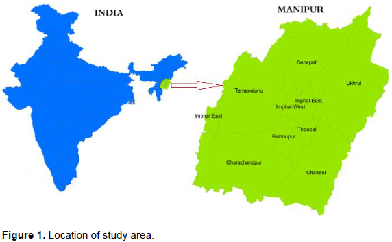
Manipur is a small state of north-eastern India mainly comprises of hilly terrain (92%) surrounding by a centrally located saucer shaped valley (1856 km
2). It is bounded by
Nagaland to the north,
Mizoram to the south, and
Assam to the west;
Burma lies to its east. The state lies at a latitude of 23°83'N to 25°68'N and a longitude of 93°03'E to 94°78'E. The total area covered by the state is 22,347 km
2. The capital lies in an oval-shaped valley of approximately 2,000 km
2 surrounded by mountains and is at an elevation of 790 metres above sea level. The slope of the valley is from north to south. The mountain ranges create a moderated climate, preventing the cold winds from the north from reaching the valley and barring cyclonic storms originating from the
Bay of Bengal (Figure 1).

Manipur may be characterised as two distinct physical regions: an outlying area of rugged hills and narrow valleys, and the inner area of flat plain (where all major Wetlands are in this region), with all associated land forms. These two areas are distinct in physical features and are conspicuous in flora and fauna. The valley region has hills and mounds rising above the flat surface. The state has four major river basins: the Barak River Basin (Barak Valley) to the west, the Manipur River Basin in central Manipur, the Yu River Basin in the east, and a portion of the Lanye River Basin in the north (Haokip, 2007).
The major wet lands of Manipur such as Loktak Lake, Pumlen Lake and other smaller lakes were discussed in terms of its changes in spatial distribution for the past 40 years. The major components of these Wetlands with its present status based on the services provided to mankind by these Wetlands are also discussed here.
DISTRIBUTION AND EXTENT OF WETLANDS
As Manipur is surrounded by hilly terrains (92%), major Wetlands concentrated in the central valley of the state (about more than 90%). Figure 2 shows the (a) percentage geographical area covered by hilly terrain and flat valley and (b) percentage area covered by Wetlands in hill and valley regions.

There are nine administrative districts in the state in which 4 districts viz., Imphal East, Imphal West, Thoubal and Bishnupur comprises in the Valley region; and the rest five districts viz., Ukhrul, Chandel, Tamenglong, Senapati and Churachanpur covers the hilly terrain. The number of Wetlands and their distribution varies in different studies reported by different researchers and government organizations mainly because of their consideration of different criteria in defining of Wetlands and ignorance of smaller wetlands (Figure 3). Figure 3 shows the total area covered by Wetlands in the state identified by different govt. organizations (column chart) and its percentage contribution to the total area (pie
chart). Even though there is variation in covering of Wetlands in different studies, it is indeed witnessed from Figure 2 that wetland covering area is decreasing except in the year 1996 reported (35%) by Fishery Department, Government of Manipur. As per the latest study done by ENVIS Centre, Government of Manipur (ENVIS, 2012), there is only 15% contribution of Wetlands to the total geographical area of the state.
Table 1 shows the district-wise distribution of Wetlands in Manipur reported by Fisheries Department, Government of Manipur (Wetlands in Manipur, 1996). Figure 4 shows the (a) district-wise distribution of Wetland and (b) distribution by types of Wetlands. According to their report (Table 1 and Figure 4), Wetlands occur in the form of ponds or lakes (5.25%), reservoirs (10.50%), lakes or swamps of beels 41.21%) and paddy cum fish culture areas (43.04%). Table 2 shows the district-wise distribution of Wetlands with its types.
According to Nationwide Wetland Mapping Project, Space Application Centre (ISRO), Ahmedabad (Nationwide Wetland Mapping Project, 1998), Wetlands cover about 529.59 km2 (about 2.37% of total geographical area of the state). There are 155 Wetlands, of which 153 wetlands covering of 528.59 km2 (99.81 %) of the total
area located in the Central Valley of Manipur, while remaining 2 wetlands covering 1.00 km2 (0.19%) are located in the hill districts (Table 2).
Table 3 shows the spatial changes of Wetland in central valley of the state and found increasing its total covering area (37.67%). This may be because of the state government initiative to conserve these Wetlands (e.g.; clearing of Phumdis in Loktak Lake and its surrounding lake done by Loktak Development Authority (Annual Administrative Report, 2011-2012)). However, such study was done only for bigger lakes. According to Wetland International South Asia (2005) wetlands of central valley covers approximately about 469 km2 (20% of the total geographical area).
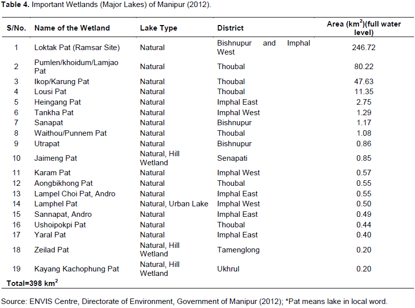
There are important 19 Wetlands in Manipur identified for conservation and management by the Directorate of Environment, Government of Manipur (Technical report, 2012) and is tabulated in Table 3.
SOCIO-ECONOMIC CONDITIONS OF MAJOR WETLANDS
Total area covered by important Wetlands is approximately 398 km2 (1.78% of the total area) in which only 1.25 km2 (0.006%) in the hilly region (Table 4). As per ENVIS report (ENVIS, 2012), there is little contribution of Wetlands in hilly region and major Wetlands are concentrating in central valley surrounded by hilly terrains and subsequently during rainy season, the eroded soils from the hills sediment to this low laying Wetlands. Sediment deposition decreases the depth of Wetlands eventually erasing the beauty and destroying the ecosystem of the Wetlands. Degradation of Wetlands in this particular region may be by many factors apart from sedimentation like deforestation in hills (Jhum cultivation), spread of settlement, increasing use of land resources for agriculture and economic development. To fulfil the increasing demand of agricultural products, use of pesticides has increased quite largely in Indian Green Revolution which started in 1965 in order to become self-sufficient in the production of food grains. Such initiative was considered successful however it affects the aqua life (birds, fish, plants, etc.) of the Wetlands destroying their life cycle and eventually these aqua lives go into extinction (that is, Pengba fish of Manipur). Such activities also deteriorate the quality of water and are a great concern and are more alarming in small water bodies (Bassi et al., 2014). The total water areas in Manipur State have shrunk from around 1000.00 km2 in 1990 to around 564.615 km2 in 2009-10 (Ngasepam et al., 2015) that means total area of Wetlands lost is nearly 44% within 20 years. The major cause of ecological problems in Manipur is due to improper planning and lack of integrated approach (Ngasepam et al., 2015). Manipur has potential to produce about 38,000 tonnes of fish; however, at present only 19,200 tonnes is producing (LDA and WISA, 1998) which is against the total requirement of 27,500 tonnes (based on the National Nutritional Standard of 11 kg per capita consumption of fish).

Loktak Lake
Among the Wetland identified for conservation and maintenance, the biggest Wetland (Loktak Lake) is under Ramsar site because of its biological richness, unique ecosystems and habitats. Under the Ramsar Convention Loktak Wetland is designated as “Wetland of International Importance” and directed to the concern authority to conserve, protect and maintain this Wetland. As such Loktak Development Authority (Annual Administrative Report, 2011-2012) which is constituted by the Government of Manipur in 1986 for overall improvement and management of Loktak Lake and its surroundings. The objective of the Authority is to check the deteriorating condition of Loktak Lake and to bring about improvement of the lake ecosystem along with development in the field of fisheries, agriculture and tourism while conserving the catchment are involving concerned Departments of the State Government. Loktak Development Authority (Annual Administrative Report, 2011-2012) monitors the vast expense of floodplain Wetlands of Manipur River known as Loktak Wetland Complex (including Loktak, Pumlen, Ikop, Kharung and Khoidum). In their Annual Administrative Report (2011-2012) for the Year 2011-2012, it is reported that overall 45 villages and 29 towns are located in and around these Wetlands comprising 71% population of the state living within the Manipur River Basin and 14% alone in and around Loktak Lake. Therefore there is huge contribution by these Wetlands for the livelihood of these people. Loktak Lake Complex has the capacity to provide water for 105 MW Loktak Hydropower Project.
Loktak Lake is famous for its “Floating Phumdi”, floating heterogeneous masses of soil; vegetation and organic matter at various stages of decomposition is a characteristics feature of the Lake. Floating Phumdi spread over 40 km2 in the southern portion of the Loktak also called Keibul Lamjao National Park is home to the various species most importantly by Sangai (Sangai in local name and Cervus eldi eldi in scientific name), an endangered Manipur brow-antlered deer and is near to extinction (Wetland International South Asia, 2005). The brow-antlered deer was first discovered in Manipur in 1839 and was reported an extinct species in 195126. Sangai are confined to 15 - 20 km2 in the southwestern part of the lake where phumdis on which the deer lives are abundant. The Sangai distribution dictated by shelter and availability of food is high near Toyaching, Pabotching and the Yang Kokchambi area (Sangsit, 2003). It was re-discovered in the Keibul Lamjao National Park (located in the vicinity of Loktak Lake) area by the environmentalist and photographer Edward Pritchard Gee in 1953 (Wikipedia, 2016). He necessitated declaring this reserve park area as a national park to protect and conserve the deer. Recently, The Manipur Forest Department (2009) also plans to translocate a section of the rare species of the endemic deer to Pumlen Pat (which is close to Loktak Lake), an effort to save Sangai from extinction, the Hindu reported (The Hindu, 2015). By taking conservative measures, it is being said that the population of Sangai increased which is tabulated in Table 5. As per Forest Department officials, around 60 km2 area is required to accommodate the newly translocated Sanagi and grow their numbers in Pumlen Pat. They confirmed that translocating will be started in the coming two to three years however; there is also a big challenge to acquire the land as the Wetland is encroached upon by fisherfolk and local villagers.
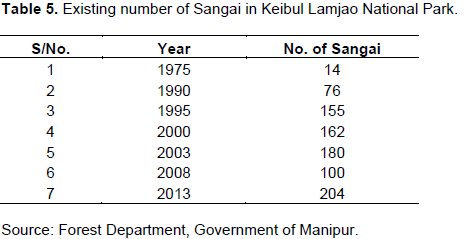
Based on Table 5, the status of Sangai is increasing year by year and is a good sign towards the effort made to protect and conserve this species. Another successful captive breeding programme is underway at the Alipore Zoological Gardens in Kolkata, and many specimens of the deer have been bred there (National Zoological Park, 2016).
But ironically, there are other sources: The Wildlife Institute of India (Sangsit, 2003) that believes the figure could be much less. In 2006, 2007 and 2008, it estimated the deer population at 90, 88 and 92, respectively. Dinabandhu Sahoo, director, Institute of Bioresources and Sustainable Development (IBSD), Department of Biotechnology, Imphal also expressed that Sangai is not protected even though it is an integral part of the sociocultural and economic life of the Manipuri people (LiveMint-e Newspaper, 2016).
Water resources development projects for irrigation, flood mitigation, agriculture and hydropower generation for example construction of Ithai barrage converted a naturally fluctuating Wetland into a reservoir leading to inundation of peripheral areas, loss of migratory fisheries, reduction and degradation of national park habitat and decline in water quality (Annual Administrative Report, 2011-2012). Another major problem is siltation which comes from hills due to Jhum (shifting) cultivation and deforestation for human settlement thereby reducing the flood attenuation capacity of the Loktak Lake Complex. Inadequate sewerage system caused inflow of untreated sewage into the lake through the inflowing rivers is another reason for declining in water quality. Declining resource pressures on rising population forced to practice harmful fishing activities thereby causing Phumdi proliferation which made choking the central sector of the lake is another concern. To stop the Wetland ecosystem degradation upto certain limit will account by improving livelihood of people within the Wetland communities.
Pumlen Lake
Pumlen Lake is the second largest fresh water Wetland in Manipur (Ngasepam et al., 2015). It is also the second largest source for fish production. The population around this lake is 469 and 29.74% of people practices fishing as their occupation. The overall fish production of the lake is 1652 kg/yr as per the study of Ngasepam et al. (2015). The study done by Ngasepam et al. (2015) particularly about Pumlen lake based on the socio-economic condition of the fishermen found several reasons for declining in the fish production rate as: (i) inflow of organic chlorine pesticides and chemical fertilizers used in the agriculture activities in and around the lakes, rivers, ponds, beels, etc. (ii) over exploitation and indiscriminate of fishing activities practiced by surrounding people (iii) fast growth of water plants (hyacinth and other weeds) spreading over the entire lake (iv) heavy siltation due to soil erosion from hills and (v) poisoning and poaching of fish. They have pointed out about the sustainable management of the Lake Ecosystem in terms of development of fish production through awareness for modern fish farming techniques and training of fishermen.
Jain et al. (2011) carried out a study of Wetlands of Manipur (Loktak, Sanapat, Utta, Pumlen, Ikop, Waithou, Poirou) based on edible plants with dietary use provided by these Wetlands. They found that the annual volume of estimated edible plants generated from these Wetlands is about 113 tonnes with net revenue of Rs 9 lakh. But, they also reported declining of Wetland edible plants (45% significantly decreased and 35% needs utmost conservation measures) in recent times due to destruction and shrinkage of Wetland habitats at places and also due to erratic rainfall that may cause flood and/or dry condition. They also added that major threat faced by these Wetlands is not only by over-exploitation of fishing but also due to siltation from the surrounding upland, conversion of marginal Wetlands into paddy fields, development projects and urbanization. They suggested about strong participatory sustainable management of these lakes by adopting sustainable harvest protocol, eco-restoration of Wetland areas and development of modern ago techniques. Jain et al. (2007) study about aquatic resources of Manipur Wetland reveals the threatened survival of aquatic resources and therefore, conservation of such resources was reported. Singh and Moirangleima (2009) studied the spatial distribution in two lakes, that is, Loktak and Pumlen from 1989 to 2002 and found the open water area of these two lakes have shrunk upto 50%. The main cause of shrinking these two lakes is by human pressure on it.
Other smaller lakes
Singh et al. (2010) study the water quality of Kharungpat located in Thoubal district with total area of 33.52 km2. They found hyper-eutrophic status of the Lake mainly due to increased piscicultural activities being carried out by the people living in the vicinity of the lake along with rapid encroachments attributing to the deterioration of the water quality of this fresh water lake. And also they urged the need for immediate remedial measures to be taken up at a faster pace for protection and conservation of this degrading lake in order to save it from further deterioration and possible extinction. Singh and Moirangleima (2009) justified the reason for ignoring of other smaller lakes (Ikoppat/ Kharungpat, Waithoupat, Utrapat, Poiroupat, Sanapat, Loushipat and Ushoipokpipat) in analyzing the changes in open water area as all the smaller lakes are old, eutrophic, marshy and seasonal, that is, they remain flooded only during the rainy season and rest of the year they dry up and the land is used for agricultural purposes. Therefore, in literature we often witnessed all the Wetland related study is done based on major two lakes (Loktak and Pumlen) so far especially for spatial changes.
REASONS FOR WETLAND DEGRADATION
The major problems faced by the Wetlands in Manipur are (i) Siltation due to deforestation in hills thereby reducing the flood attenuation capacity of Wetlands (ii) Deterioration of water quality due to using of pesticides in agricultural activities in and around the Lake; and inflow of untreated sewage into the lake through the inflowing rivers leading to decline in water quality. These two problems are subject to act fast to stop further degradation and to save the future livelihood of the people. Due to the first problem, the sudden flash flood in the valley region and untimely drought are likely to increase in the future. The second problem will create changing the life cycle of aqua life and even death thereby reducing their numbers. People could no longer use water directly for domestic purposes or agricultural activities and overall disturbs the ecosystem of these Wetlands as well as to the daily normal life of the people. By understanding these major problems, efficient management of these Wetland are utmost demanded. The siltation problem could not stop 100% however; it can be reduced up to certain degree by preventing the vast deforestation in hills, giving awareness to the nearby people about losing of good services received from these Wetlands and make sure to understand about siltation scientifically and how to prevent them. Regularly removal of deposited soils and cleaning of these Wetlands will also be able to prevent flood results from decreasing depth of such Wetlands. Construction of small weir just at the entrance of such Wetlands will bring considerable solution to siltation problem. Using of pesticides, of course, increases the agricultural products but its several impacts on the ecosystem of Wetlands need to address timely reaching to every person. Using of pesticides can be reduced by introducing organic farming and the benefits of organic farming need to be accelerated by explaining about the health hazards caused by consuming foods comes from pesticides used farms. Proper disposal of sewage need to be implemented and effective operational use of sewage treatment plant is required. Local body with concern authority must join hands to implement the efficient management of Wetlands. It is evident that several government and non government organization are setup to take care of these Wetlands but the ideas and direction are mostly remains unknown to common people. There is lack of physical interaction between the concern authority and the people of the surrounding area and thereby no benefits can be achieved for year-long identification of problems about these Wetlands. Another problem faced is that people could not understand the scientifically written research findings, in this regard local non-governmental body need to help people understand easily. Due to Wetland ecosystem degradation while the population is increasing, people forced to practice the harmful fishing activities in the vicinity of the lake. Such practice can be reduced by improving their livelihood or giving them alternate livelihood opportunities/occupation like growing of mushrooms, bamboo plantation, establishment of separate fish farms, weaving cloths, etc.
The spatial distribution of Wetlands is decreasing so fast; open area have shrunk 50% as per Singh and Moirangleima (Sangsit, 2003) study from 1989 to 2002 in two major Lakes and only 15% to the total area of the state contributes as per latest ENVIS report (ENVIS, 2012). All studies were mainly based on ecological and socio-economic studies (Jain et al., 2011; Ngasepam et al., 2015; Jain et al., 2007; Ningthoujam et al., 2009; Rai and Raleng, 2011; Rai and Singh, 2014). It is also found that there is lack of educational/institutional scientific research as all studies were mainly carried out by Government set up organization like Loktak Development Authority; Directorate of Environment). The application of modern techniques such as Remote Sensing and Geographical Information system is quite less in the monitoring of Wetlands except few studies (Singh and Moirangleima, 2009; Rai and Singh, 2014). It is also witnessed that all the studies were mainly done about the largest lake, that is, Loktak Lake (Laishram and Dey, 2013) and second largest lake, that is, Pumlen Lake (Ngasepam et al., 2015) while the others smaller lakes were totally ignored. The spatial representation of changes occurring in and around the Wetlands is not done yet sufficiently which will otherwise help people understand more easily about the Wetlands status. Such changes were reported in numeric or long sentences in all the studies which are difficult to understand by the common people. Therefore, application of modern scientific techniques (such as RS and GIS) which displays the spatial changes in terms of figures, maps will help people understand quickly is required for effective solution to Wetland understanding.
The authors have not declared any conflict of interests.
REFERENCES
|
Annual Administrative Report (2011-2012). Loktak Development Authority, Government of Manipur.
|
|
|
|
Annual Report (2008-2009). Central Pollution Control Board, Government of India.
|
|
|
|
|
Bassi N, Kumar MD, Sharma A, Saradhi PP (2014). Status of Wetlands in India: A review of extent, ecosystem benefits, threats and management strategies. J. Hydrol. Regional Stud. 2:1-9.
Crossref
|
|
|
|
|
Brij G (1991). Biodiversity in Inland Aquatic Ecosystems in India: An Overview. Int. J. Ecol. Environ. Sci. 23:305-313.
|
|
|
|
|
ENVIS (2012). Centre, Directorate of Environment, Government of Manipur, 2012.
|
|
|
|
|
Finlayson CM, Spiers AG (1999). Global Review of Wetland Resources and Priorities for Wetland Inventory. CD-ROM, Supervising Scientist Report 144, Canberra, Australia, 1999.
|
|
|
|
|
Forest Department (2009). Government of Manipur "Keibul_Lamjao_National_Park". Retrieved on 8th June, 2016.
|
|
|
|
|
Ghermandi A, van den Bergh JCJM, Brander LM, Nunes PALD (2008). The Economic Value of Wetland Conservation and Creation: A Meta-Analysis, Working Paper 79, Fondazione Eni Enrico Mattei, Milan, Italy, 2008.
|
|
|
|
|
Haokip N (2007). Basine Delineation Map of Manipur, Profile on State of Environment Report of Manipur, 2006-07, Ministry of Environment and Forests, Manipur, 2007.
|
|
|
|
|
IPCC (2000). In N. Nakiaeenoviae (Ed). A special report of IPCC working group III: Summary for policymakers, emission scenarios. Cambridge: Cambridge University Press.
|
|
|
|
|
Jain A, Roshnibala S, Kanjilal PB, Singh RS, Singh HB (2007). Aquatic/semi-aquatic plants used in herbal remedies in the Wetlands of Manipur, Northeastern India. Indian J. Tradit. Know. 6(2):346-351.
|
|
|
|
|
Jain A, Sundriyal M, Roshinibala S, Kotoky R, Kanjilal PB, Singh HB, Sundriyal RC (2011). Dietary use and conservation concern of edible Wetland plants at indo-burma hotspot: a case study from northeast India. J. Ethnobiol. Ethnomed. pp. 7-29.
Crossref
|
|
|
|
|
Laishram J, Dey M (2013). Socio-Economic condition of the communities dependent on Loktak Lake, Manipur: A study on five lakeshore villages. Int. J. Ecol. Environ. Sci. 39(2):87-96.
|
|
|
|
|
LDA, WISA (1998). Project Management Plan, Sustainable Development and Water Resource Management of Loktak Lake. Loktak Development Authority and Wetland International South Asia, 1998.
|
|
|
|
|
Lehner B, Doll P (2004). Development and validation of a global database of lakes, reservoirs and wetlands. J. Hydro. 296(1-4):1-22.
Crossref
|
|
|
|
|
LiveMint-e Newspaper (2016). "Keibul Lamjao: The world's only floating national park" published on 8th July 2016.
|
|
|
|
|
Millennium Ecosystem Assessment (MEA) (2005). Ecosystems and Human Well-being: Synthesis, Island Press, Washington, DC, 2005.
|
|
|
|
|
Mitsch WJ, Nahlik A, Wolski P, Bernal B, Zhang LR (2009). Tropical Wetlands: seasonal hydrologic pulsing, carbon sequestration, and methane emissions. Wetlands Ecol. Manage. 18(5):573-586.
Crossref
|
|
|
|
|
National Zoological Park (2016). Mathura Road, New Delhi, India "Sangai Deer (Cervus eldii eldii)", Retrieved on 16th July 2016.
|
|
|
|
|
Nationwide Wetland Mapping Project (1998). Space Application Centre, Ahmedabad, 1998.
|
|
|
|
|
Ngasepam RS, Devi LN, Singh CK, Shomendra M (2015). Socio-economic condition of the fishermen community of Pumlen Lake: A case study of Tokpaching village of Thoubal District, Manipur. Voice Res. 4(1):39-43.
|
|
|
|
|
Ningthoujam DS, Sanasam S, Nimaichand S (2009). Screening of Actinomycete Isolates from Niche Habitats in Manipur for Antibiotic Activity. Am. J. Biochem. Biotechnol. 5(4):221-225.
Crossref
|
|
|
|
|
Prabhat KR, Singh MM (2014). Wetland Resources of Loktak Lake in Bishenpur District of Manipur, India: A Review. Sci. Technol. J. 2(1):98-103.
|
|
|
|
|
Rai PK, Singh MM (2014). Wetland Resources of Loktak Lake in Bishenpur District of Manipur, India: A Review. Sci. Technol. J. 2(1):98-103.
|
|
|
|
|
Rai SC, Raleng A (2011). Ecological Studies of Wetland Ecosystem in Manipur Valley from Management Perspectives, Ecosystems Biodiversity, PhD. Oscar Grillo (Ed.), 2011.
|
|
|
|
|
Ramsar Secretariat, Convention on Wetlands (Ramsar, Iran, 1971), 46th Meeting of the Standing Committee Gland, Switzerland, 8-12, 2013.
|
|
|
|
|
SACONH (2004). Inland Wetlands of India-Conservation Atlas. Salim Ali Centre for Ornithology and Natural History, Coimbatore, India; 2004.
|
|
|
|
|
Sangsit S (2003). Dancing Deer of Manipur. News Letter, Wild Life Institute of India, Volume 10, number 3. Archived from the original on 13 August 2005. Retrieved on 16th June, 2016.
|
|
|
|
|
Singh AL, Moirangleima K (2009). Shrinking water area in the Wetlands of the central valley of Manipur. Open Renew. Ener. J. 2:1-5.
Crossref
|
|
|
|
|
Singh KK, Sharma BM, Usha Kh (2010). Ecology of Kharungpat Lake, Thoubal, Manipur, India: Part-I Water Quality Status. Ecoscan 4(2-3):241-245.
|
|
|
|
|
Technical report on Wetlands of Manipur (2012). Directorate of Environment, Government of Manipur, 2012.
|
|
|
|
|
The Hindu (2015). "Manipur to translocate critically endangered Sangai deer" published on 16th June, 2015
|
|
|
|
|
Turner RK, van der Bergh JCJM, Soderqvist T, Barendregt A, van der Straaten J, Maltby E, van lerland EC (2000). Ecological economic analysis of Wetlands: scientific integration for management and policy. Ecol. Eco. 35(1):7-23.
Crossref
|
|
|
|
|
Verma M (2001). Economic valuation of Bhoj wetlands for sustainable use, report for World Bank assistance to government of India. Management Capacity-Building. Bhopal: Indian Institute of Forest Management.
|
|
|
|
|
Wetland International South Asia (2005).
|
|
|
|
|
Wetlands in Manipur (1996). Reported by Fisheries Department, Government of Manipur.
|
|
|
|
|
Wikipedia (2016). "Keibul Lamjao National Park" Retrieved on 8th July, 2016.
|
|