Groundwater vulnerability is an overlay method that is used to determine the ability of pollutants to penetrate the aquifer and harming it. This method helps decision makers by highlighting expected areas to be polluted. In Jordan, groundwater is the main water resource the country uses to match its demand. The groundwater basins in Jordan are divided into 12 major basins; some are rechargeable and others are fossil. Many basins are over exploited; Amman Zarqa basin is a clear example for this case. In this study, a groundwater vulnerability map was produced for study area using SINTACS, GOD and DRASTIC indices to study the vulnerability of the aquifers throughout the targeted area. The different resulted maps show different vulnerability classes ranging from low to high reflecting the environmental, hydrological and hydrogeological settings of the groundwater and its recharge ability. The resulted map shows wide variation in groundwater vulnerability in different sites within the targeted area. Within the basin, areas with higher vulnerability are those with friable aquifer materials and shallow groundwater depths. Medium and low vulnerability classes exist too because of the variations of the environmental settings within the targeted areas.
Groundwater vulnerability is an overlay method that is used to determine the ability of pollutants to penetrate to the target aquifer and to harm it. This method helps decision makers by shedding light on pollution areas expected to pollute groundwater aquifers as caused by human activities on the ground surface.
The theory of groundwater vulnerability was ï¬rst introduced in the 1960s in France to create an alertness of groundwater contamination (Vrba and Zaporozec, 1994). It can be deï¬ned as the possibility of percolation and diffusion of contaminants from the ground surface into the groundwater system. Vulnerability is usually considered as an ‘‘intrinsic’’ property of a groundwater system that depends on its sensitivity to human and/or natural impacts (Rahman, 2008). ‘‘Specific’’ or ‘‘integrated’’ vulner ability, on the otherhand, combines intrinsic vulnerability with the risk of the groundwater being exposed to the loading of pollutants from certain sources (Vrba and Zaporozec, 1994). Groundwater vulnerability deals only with the hydrogeological setting and does not include pollutant attenuation. The natural hydrogeological factors affect the different pollutants in different ways depending on their interactions and chemical properties.
Many approaches have been developed to evaluate aquifer vulnerability. They include process-based methods, statistical methods, and overlay and index methods (Tesoriero et al., 1998). The process-based methods use simulation models to estimate the contaminant migration, but they are constrained by data shortage and computational difficulties (Babiker et al., 2005).
Different environmental parameters interfere when anticipating the amount and location of impurities that may affect the aquifers. Groundwater settings, hydrological and hydrogeological conditions, landuse parameters, environmental issues, soil parameters and other elements which may vary from one aquifer to other and from one area to another are used to assess the vulnerability of groundwater (Vrba and Zoporozec, 1994).
There are several groundwater pollution vulnerability evaluation systems, three methods or indices were applied within this work: SINTACS, GOD and DRASTIC. Among these models, the SINTACS method used in this study was developed by Civita (1990b, 1993, 1994) and Civita and De Maio (1997) to evaluate relative groundwater pollution vulnerability using seven hydrogeological parameters (Kuisi et al., 2006). It is a development of the US DRASTIC model adapted to Mediterranean conditions (Rahman, 2008). To evaluate the groundwater vulnerability for the study area, SINTACS model was preferred for different considerations, these include its suitability for application in Mediterranean regions (Civita, 1990a), its low cost depending on available datasets, and relative, dimensionless and non-measurable properties that depend on the aquifer characteristics as well as the characteristics of the wider geological and hydrological environment (Al-Amoush et al., 2010).
Zarqa River Basin is one of the most developed areas in Jordan (Figure 1), the expansion of Amman and other towns has been enormous, where before large areas of grazing land and fertile agricultural land could be found between Amman and other towns, it has now developed into one large urban conglomerate (Shatanawy, 2002).
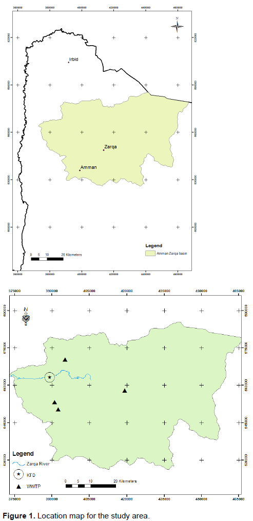
Zarqa River basin is capable of supporting forests and agricultural activities. Natural forests occurring in the mountainous part are composed of oak, pine, juniper, wild olive and cypress. Agricultural activities and their associated weeds have supplanted the indigenous flora communities. Agriculture is scattered with the basin from rainfed orchards, olive and field crops to irrigated agriculture on the river banks and the Jordan valley. Private irrigated area using groundwater as a source of irrigation water can be found in scattered places in the middle and the eastern part of the basin. The main industrial activities in the basin are al-Hussein thermal power plant, the oil refinery, textile industries, paper processing, leather production, food Industries, distilleries, drugs and chemical industries, intermediate petrochemicals, engineering industries, paper and carton products, and mining industries (Phosphate). These activities are considered the main source of pollution to the surface and groundwater. In addition to that, the basin includes four municipal wastewater treatment plants whose effluent has reached 70 MCM/year and is discharged to the river. This volume is expected to reach 180 MCM by the year 2025 (Shatanawy, 2002). Groundwater represents the main source of water supply in the basin. Most of the groundwater exists in and is being extracted from the Basalt and Amman-Wadi Sir aquifers (Mohammad, 2016).
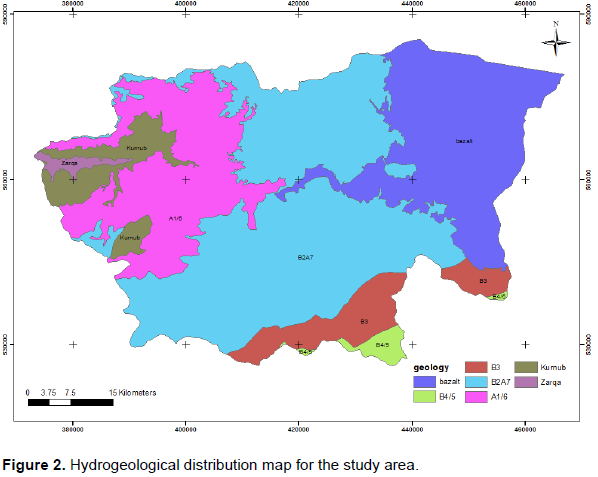
The main groundwater bodies are found in bedrock aquifers and they form the main groundwater sources. The main aquifers are composed of sandstone like Kurnub and Ram groups, the carbonate aquifers like Amman Silicified Limestone A7/B2 and Belqa B4/B5 group, in addition to the basalt aquifer. Within the targeted area, the most important aquifers are the B2A7 aquifer and the Kurnub sandstone aquifer systems (Figure 2).
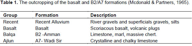
ZRB is considered one of the most important groundwater basins in Jordan with respect to its groundwater resources. The safe yield of ZRB aquifer is about 87.5 MCM which makes about 32% of the country’s renewable groundwater resources (MoE, 2012). The rock outcropping in the study area ranges in age from Creteaceous (Ajlun) to recent (Mcdonald and Partners, 1965). The succession from top to bottom is shown in Table 1.
Wadi Sir Formation A7 (Turonian)
It is the upper most unit of the Ajlun group. It outcrops extensively both in the north, central and south parts of the area. The massive crystalline limestone is karstic and weathered in the top 20 m of the formation. Below them there is a general increase in the marl chalky limestone and thin marl beds occur, indicating a transition into the underlying Shueib formation. The formation ranges in thickness between 50 and 250 m dipping to the east and northeast.
Amman formation B2 (Santonian_Campanian)
It is a cyclic deposit of chalk, phosphate, silicified phosphate, limestone and Chert. Its thickness ranges reaches 47 m in the study area.
The plateau basalt (Oligocene-Pleistocene)
Basalt outcrops in the northeastern part of the basin. Six major flows have been identified in the study area. Thin layers of clay and gravel consisting of limestone and Chert pebbles have been encountered between the successive flows. The basalt thickness in the northeastern part is 400 m and wedges to the west towards the periphery of the flows.
Younger alluvium formation
The younger alluvial consists of thin deposits overlying the basalt in the cemented out-wash and the old river terraces.
This study aims on assessment of the groundwater vulnerability of the Zarqa River basin upper aquifers using three different indices; this will help in protesting the groundwater in the targeted area from different pollution that might harm the aquifer system.
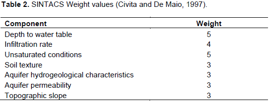
The parametric models like SINTACS belong to the point count system model group in which every factor has not only its own score, but also an additional weight to reduce or amplify its importance during the analysis. The additional weight is set in relation to environmental characteristics, such as high dispersion phenomena from surface water bodies to groundwater or widespread pollution sources (Kuisi et al., 2006). The acronyms SINTACS stands for the seven parameters used in the model which are: water table depth (S), effective inï¬ltration (I), unsaturated zone (N), soil media (T), aquifer media (A), hydraulic conductivity zone (C), topographic slope (S). The aforementioned seven parameters are used to deï¬ne the hydrological setting of an area. These seven parameters are further sub-divided into ranges (or) zones, representing various hydro logical settings and are assigned different rating in a scale of 1 in 10 based on the rating chart (Kuisi et al., 2006). The rating assigned to each of these ranges or zones indicate their relative importance within each parameter, in contributing to aquifer vulnerability. The seven parameters are themselves not considered to be equally important in vulnerability assessment.
The parametric models utilized belongs to the Point Count System Model (PCSM group) in which every factor has not only its own score, but also an additional weight in order to reduce or amplify its importance during the analysis. The additional weight is set in relation to environmental characteristics, such as high dispersion phenomena from surface water bodies to groundwater or spread pollution sources. The model used to predict aquifer vulnerability is SINTACS, developed by the National Research Council (Civita and De Maio, 1997).
The vulnerability index is given by rating seven parameters that is multiplied in each cell for the chosen weights string. In fact, one of the five described scenarios has to be identified and related string is assumed. According to this equation:
where Pi = score of each of the 7 parameters that the method considers, Wi = relative weight. Where Pi is the rating of each parameter and Wi is the weight of the chosen hydrogeological scenario. For every cell, it is given in such way a final score ranging from 26 to 260.
If we suggest the environmental impacts, there are normal impacts, then: Wi for each parameter is shown in Table 2.
GOD Index
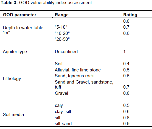
This index is characterized by a rapid assessment of the aquifer vulnerability; it was developed by Foster in 1987 and 1998 (Ferreira and Oliveira, 2004) for studying the vulnerability of the aquifer against the vertical percolation of pollutants through the unsaturated zone, without considering their lateral migration in the saturated zone. Table 3 shows the GOD method. The approach used in this model takes in consideration three parameters: (1) Groundwater occurrence; (2) Overall aquifer class; (3) Depth table of the groundwater.
The GOD index which is used to evaluate and map the aquifer vulnerability caused by the pollution, was calculated by multiplication of the influence of the three parameters using the following equation:
GOD Index = Cl × Ca × Cd
where Ca is the type of aquifer, Cl is the lithology of the unsaturated zone and Cd is the depth on the water surface. The GOD indexes are divided into five classes and vary between the extreme values ranging from 0 to 1.
DRASTIC Index
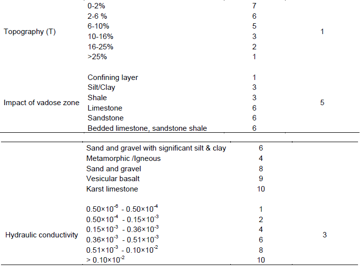
The DRASTIC index is one of the vulnerability indices that could be applied in Jordan, because of its applicability on climatic conditions, aquifer distribution and aquifer settings. In addition to that, the DRASTIC index has been selected according to its wide variation of parameters that really affect the groundwater system in any environment. In this model (DRASTIC), spatial datasets on depth to groundwater, recharge by rainfall, aquifer type, soil properties, topography, impact of the vadose zone and hydraulic conductivity of the aquifer are combined to assess the vulnerability of the aquifers to surface activities (Table 3) (Engel et al., 1996). The following equation governing DRASTIC index DI was defined by Knox et al. (1993), Fortin et al. (1997) and Fritch et al. (2000):
where DI is the DRASTIC Index, Dr is the rate of the D factor and Dw is the weight of the D factor, Rr is the rate for the recharge factor and Rw is the weight for the recharge factor, Ar is the rate for the aquifer media factor and the Aw is the weight to the aquifer media factor, Sr is the rate to the soil media factor and Sw is the weight to this factor, the Tr is the rate to the topography factor and the Tw is the weight to that factor, Ir is the rate of the impact of the vadose zone rate and Iw is the weight, and finally Cr is the rate for the hydraulic conductivity rate and Cw is the weight to this factor; this DRASTIC index in the equation is considered as an indicator for pollution potential (Table 4). The effect of different parameters on groundwater vulnerability has been described by Piscopo (2001).
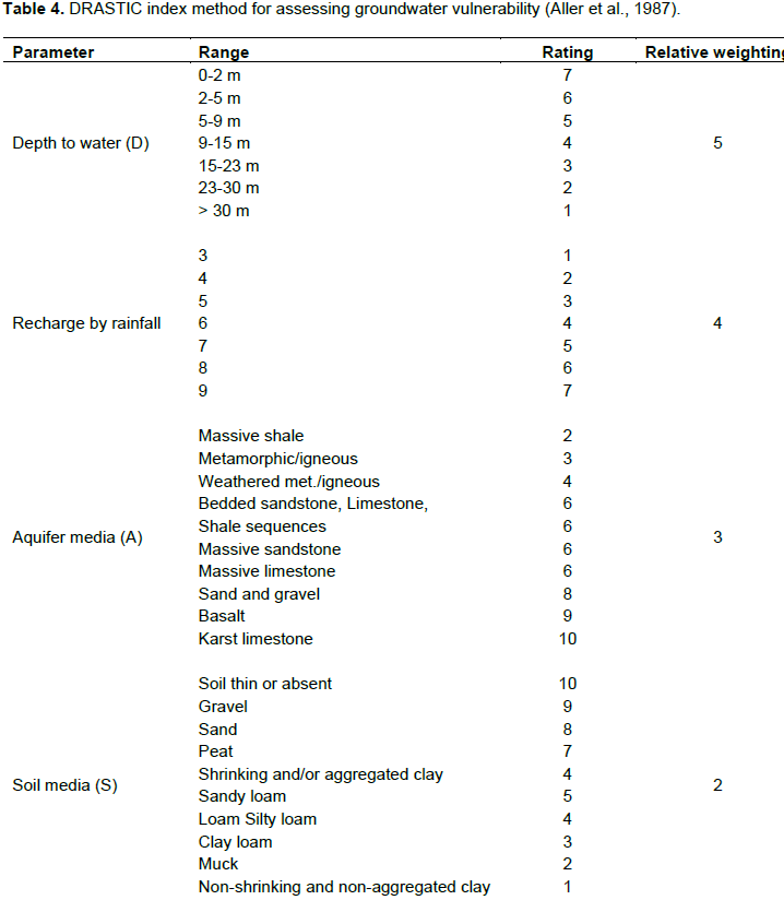

For building the groundwater vulnerability map, different environmental parameters, which interfere while anticipating amount and location of impurities, that may affect the aquifers, were taken into consideration. Groundwater settings, hydrological and hydro-geological conditions, land use parameters, environmental issues, soil parameters and other elements, which may vary from one aquifer to another and from one area to another were used to determine the vulnerability of groundwater (Vrba and Zaporozec, 1994). The different spatial parameters of the aquifer as obtained (geology, recharge, water table, soil texture, etc.) were exported into GIS and the equation for calculating groundwater vulnerability with DRASTIC Index were used to deduce different vulnerability classes.
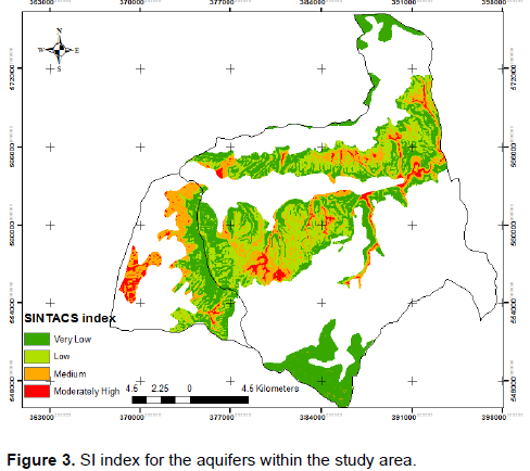
The resulted map of SINTACS index is as shown in Figure 3. This shows that the B2A7 aquifer has 2 vulnerability classes, the very low and low classes which reflect the safe situation of ground water; meanwhile, the Kurnub aquifer reflects four vulnerability classes ranging from very low to moderately high vulnerability.
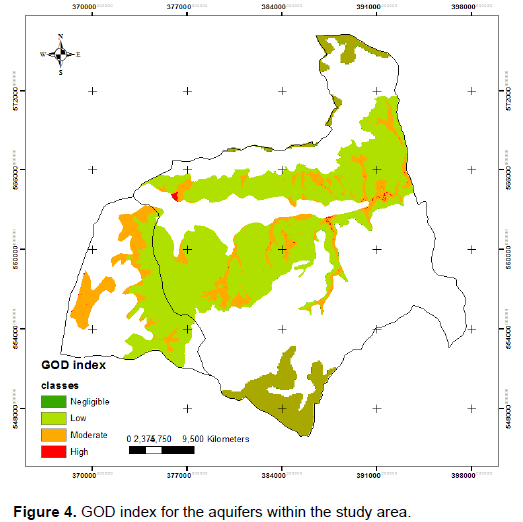
While the GOD index can be divided into five categories: negligible (0-0.1), low (0.1-0.3), moderate (0.3-0.5), high (0.5-0.7), and very high (0.7-1) (Foster et al., 2002); then the vulnerability classes within the targeted area are as shown in the Figure 4 with 3 vulnerability classes ranging from negligible to high vulnerability class.
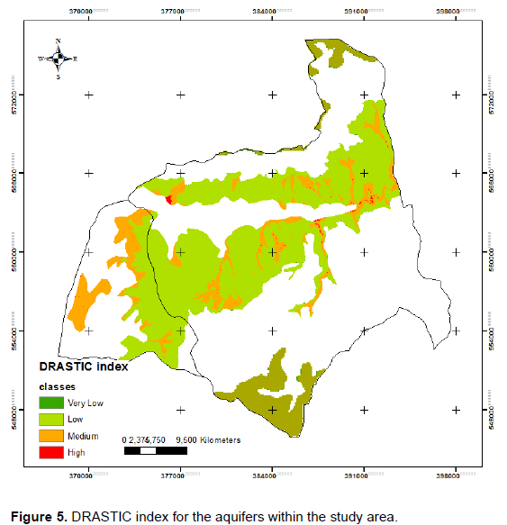
Also, the resulted map of DRASTIC index is as shown in Figure 5. This shows that the B2 A7 aquifer has 2 vulnerability classes, the very low and low classes which reflects the safe situation of ground water; meanwhile, the Kurnub aquifer reflects four vulnerability classes ranging from very low to high vulnerability, it is very clear that the lower water table are the areas with higher risks. It cannot be noticed that DI and SI results are compatible to each other, because of the high similarity of the environmental conditions that are taken into consideration during application of the two indices.
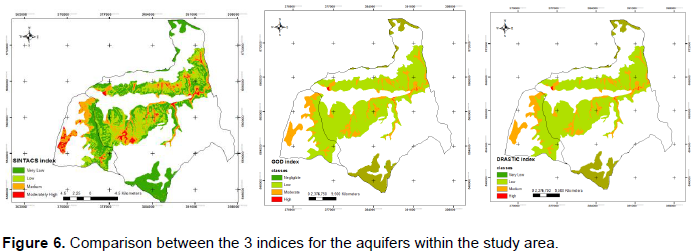
As shown in Figure 6, it could be noticed that both DRASTIC and GOD vulnerability indices used within this work are very compatible to each others and shows mostly the same high and low risk areas within the targeted area; areas cover by B2A7 aquifers are with low to medium vulnerability classes for all indices, and as shown from different resulted map the high and very vulnerability classes in all indices are coming with Kurnub aquifer which is because of the aquifer media "sandstone" which reflects higher vulnerability potentiality. In the meanwhile, SINTACS vulnerability map shows much variability of classes and this comes from the detailed of this index in the S factor or depth to water table which started by very small intervals.
As a conclusion, this paper concludes that most of the targeted aquifers within the study area are with low to very low vulnerability class, but this does not mean that the water situation is not threatened. The high and medium vulnerability classes exists too, however, any activity to take place within the outcropped aquifer will affect the groundwater resources there and then to study an effective assessment to any action to be done.
Among the three applied methods, SINTACS method is the best to be applied because of its more detailed in showing the vulnerability classes and its variety in description aquifers like GOD method which is a resulted more for Karst aquifer.