Full Length Research Paper
ABSTRACT
Flooding has been a critical problem in our globe causing huge damage on human lives as well as socio-economic and environmental assets. The upper Awash river basin in Ethiopia, which is the target of this study, is one such region that is affected by recurrent flooding. Thus, there is a need to develop appropriate and sustainable management mechanisms to mitigate flood impacts. An integrated flood management approach which accounts for social and stakeholder involvement, as well as environmental and economic condition of a basin; in addition to technical flood mitigation options (such as structural and/or non-structural measures) can be an alternative. This study emphasized on the need to consider socio-economic-environmental aspects of a basin while proposing IFM options considering the upper Awash river basin, Ethiopia. It employed structured and semi-structured interviews, field observations, and community and government official consultations to investigate the socio-economic and environmental situations of UARB with the underlying objective of examining existing flood impacts in the basin. The study formulated the basin current socio-economic and environmental baselines. It also pin-pointed the concerned stakeholders in UARB, that shall be addressed and consulted during planning and developing of IFM mechanisms. Ultimately, the results from the interviews and the surveys were used as an essential input to develop flood risk maps within the context of integrated flood management options.
Key words: Awash River Basin, flood impacts, socio-economic baseline, environmental baseline, integrated flood management approach, flood risk map.
INTRODUCTION
Flooding is one of the many disasters that has caused tremendous damages in human lives and social and environmental assets. Recent report of the United Nation, UN (2015), reveals that flood affected 2.3 billion people from 1995 to 2015 in the world. This contributes to 56% of total affected people by weathered-related disasters. The report also states that there were 3062 flood disasters in those years that shares 47% of all geophysical hazards that occurred in our globe. Flood events are becoming severe and flood frequency has been increasing, resulting to distraction of agricultural areas and food supply sectors and leads to malnutrition problems (UN, 2015).
Flood events have been rising due to an expansion of human-induced land-use interventions (Chawla and Mujumdar, 2015; James and Lecce, 2013; Roggeret al., 2017; Verburg et al., 2012; Wu et al., 2018) and climate change (Didovetsa et al., 2019; Hettiarachchi et al., 2018; IPCC, 2007; Maghsood et al., 2019; Sen, 2018). Urbanization and industrialization, which are among the main factors, have played a major role on globe’s climate change. The urbanization usually leads to unprecedented deforestation and land use and land type changes. These result in decline of land perviousness and increase the amount of sunlight reflected back from the earth’s surfaces. As a result, the atmosphere warms up; lots of water evaporates from seas, oceans, as well as from any water resources located on the earth. This creates a feedback loop between global climate change and extreme hydrological events (that is, flooding and drought). Consequently, our globe receives high rainfall intensity which leads to disastrous flood events yearly.
During the last centuries, flooding has also been one of the severe national disasters of Ethiopia (EM-DAT, 2019). It has been anticipated in the areas of a river side as well as in areas with low water percolation capacity; often seen in southern, north-eastern, and eastern part of the country (NDRMC, 2016). Upper Awash river basin (Figure 1) is one of the country’s basins which has been affected by recurrent flood. In the basin, flooding has been a critical problem causing thousands of people being affected and triggering huge economical losses. Flood events of high significance were recorded in Sebeta Hawas, Wolmera and Egeria woredas (that is, an administrative boundary making up zone) in September 2017, Liben Chukuala and Bora woredas in the years 2014, 2016, and 2017, at Fentale in 2012, 2015, and 2017, and in 2019 at Ilu and Sebeta Hawasa woredas.
Particularly, in the aforementioned woredas of upper Awash basin, flooding has led thousands of households to displace from their home and caused for loss of thousands of livestock. It also provoked huge economic loss and environmental impacts. Infrastructures, health and educational institutions deteriorate from year to year; schools in the basin often started late because of the flooding and health centers are not functional in the rainy season of the country.
However, unlike most types of disasters like volcanoes and earthquakes, flood is preventable and manageable through proper implementation of integrated flood management approach and thus environmental friendly and sustainable measures and strategies can be achieved.
An integrated flood management approach deals with integrated rather than fragmented approach (Grabs et al., 2007; Topalovic and Markovic, 2018; WMO, 2017, 2009). The traditional approach which is flood prevention mainly through structural measures that separate the river from flood plain is replaced by an integrated approach in order to maximize the net benefits of flood plains and minimize the loss of life. An integrated flood management approach opens for different stakeholders to actively participate in solving flooding problem and achieving optimal solutions. Thus, it takes into account social, economic and environmental perspectives of both the flood and possible flood management measures. WMO (2006a) also states that government ministries and agencies, government disaster management institutions, flood-prone communities, scientific institutes or organizations, registered non-governmental organizations, voluntary organizations, and private sectors are some of the possible stakeholders that shall be taken into account while planning and developing flood management options. Various studies have been performed confirming and supporting IFM approach to attain sustainable solutions for alleviating adverse impacts of flooding (Ballesteros-Cánovas et al., 2013; Brears, 2015; Zlatanovaa et al., 2014).
Considering socio-environmental-economic studies while planning and developing IFM mechanisms is very vital as they enhance to choose appropriate flood mitigation options. Documents which are jointly prepared by WMO, APFM and GWP also clearly stated the need of environmental, economic, and social aspects in IFM process (WMO, 2006a, b, 2007). Structural and/or non-structural flood mitigation measures possibly induce modification in socio-environment-economic situations of the basin resulting either in benefit and/or drawback. However, the impacts of those mitigation options shall be optimized in order to get maximum benefit from it.
This paper aims to show the current social, economic and environmental status of upper Awash basin as well as correspondent flood impacts in the basin and thus it indicates and emphasizes the need of integrated flood management solutions for the basin. The paper started by introducing the topic and gave general overview of flood events in our globe as well as in the selected basin. Then, it described the basin as well as methods used to perform the study. Following, it formulated the socio-economic and environmental baselines and thus examined the flood impacts in upper Awash basin. Thereafter, it discussed the need of IFM approach while implementing flood management options in the basin, such as social, economic and environmental aspects besides structural/non-structural measures, and consequently developed flood risk map for the basin. Finally, it binds up with conclusions.
MATERIALS AND METHODS
Descriptions of the study area
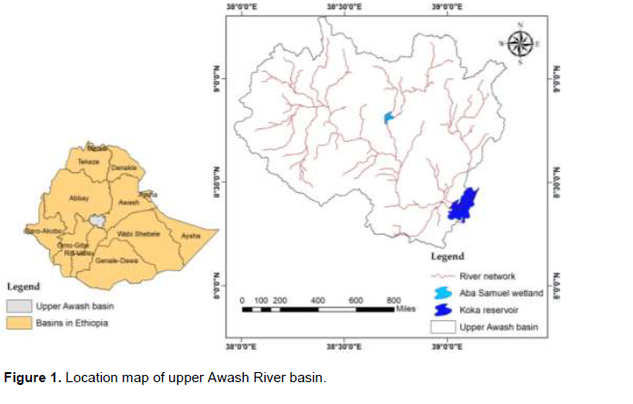
The upper Awash River basin is located in between longitude 8° 46' 24.6" to 9° 3' 18.8" N and latitude 37° 57' 8.45" to 39° 17.24' 92” E (Figure 1). The basin has an elevation difference from about 3500 m at Dendi woreda to about 1500 m at its eventual terminal in Koka Dam. It lies on four regional states of the country such as Oromia, SNNP and Amhara and on Addis Ababa city administration. It is bounded in the west by the Abbay river basin, in the southwest by the Omo-Gibe and Rift Valley lakes basin, and in southeast by Wabishebele. The major tributaries include Kebena, Great and Little Akaki, Mojo, Holeta, Alito, Teji, Gilo and Kelina rivers.
The basin has a bi-modal precipitation pattern with double peak rainy season. The main rainy season covers from June to September and the second minor rainfall occurs from March to April. It receives annual rainfall ranging from about 2200 to 400 mm.The basin is dominantly covered with undulating plain sharing 41.2% and followed by flat (24.3%) and rolling (18.9%) plains. Annual cropland is the dominant land cover of the study area and contributes about 71% of the watershed while grassland and moderate and spare forest covers a total of 0.8 and 10.2% of the watershed respectively.
METHODOLOGY
As proposed by WMO (2006a), different stakeholders shall be considered in order to develop integrated flood management mechanisms. Consequently, concerned stakeholders of upper Awash basin were selected which include government offices flood-prone communities, scientific institutions or organizations such as school and health institutions, and non-governmental organizations/ private sectors (“The need of integrated flood management approach”). The study uses both primary and secondary data to formulate the current baseline conditions of upper Awash basin. Structured and semi-structured interviews were also used in order to collect information. Depending on the level of involvement, the aforementioned stakeholders have been communicated, consulted, and interviewed. Formal meeting and discussion with woredas’ and kebeles’ (that is, administrative boundary making up woreda) officials have been performed. Woreda’s disaster risk management office as well as the communities living in the basin have been interviewed and consulted in order to assess status of socio-economic assets as well as the extent of flood impacts. On top of these, field visit and observation has also been performed in order to examine the environmental situation and to assess flood affected areas of the basin.
RESULTS AND DISCUSSION
Socio-economic and environmental baseline of upper Awash basin
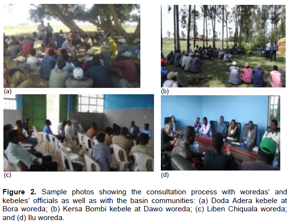
As mentioned earlier, concerned stakeholders were consulted and interviewed for both socio- economic and environmental assessment of the basin. In addition, data were also collected from Woredas’ Administrative Offices and Woredas’ Disaster Risk Management Offices. Figure 2 shows sample photos taken during consultation with woredas’ and kebeles’ officials as well as with the basin communities.
Socio-economic status of upper Awash basin
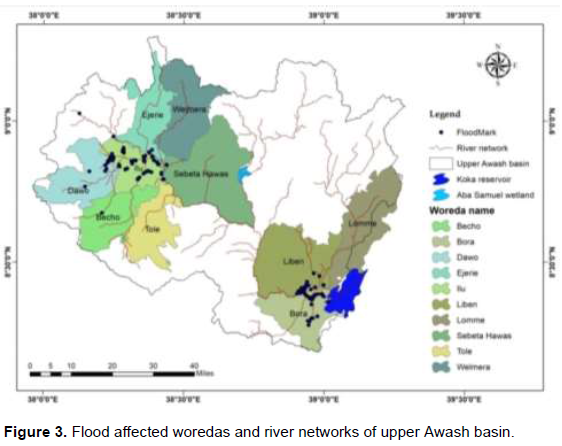
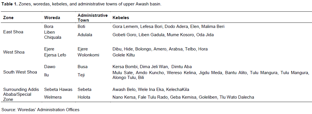
The upper Awash basin covers about 11,400 km2 and embeds eight flood affected woredas such as Bora, Liben Chiquala, Ejere, Ejersa Lefo, Dawo, Ilu, Sebeta Hawas, and Welmera as shown in Figure 3. Whereas, Lomme and Tole woredas are not flood prone areas. In Table 1, the administrative structure of the basin is clearly summarized. Welmera and Sebeta Hawas have large area coverage with 809.27 and 688.25 km2, respectively; followed by and Liben Chiquala (644.22 km2), Ejere (569 km2), Bora (487.57 km2), Dawo (410.94 km2), Ejersa Lefo (351.76 km2), and Ilu (288.3 km2).
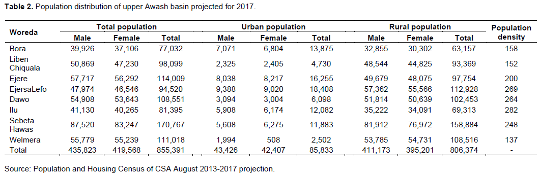
According to CSA (2015), the population of upper Awash basin is about 855,391 and out of this 435,823 are male and 419,568 are female. 94% of the pollution lives in rural area and use agriculture and livestock production as a main source of income. Population density ranges from 282 persons/km2 in the urban area to 137 persons/km2 in the rural areas of the basin. The population distribution of the basin by residence area and sex is described in Table 2.
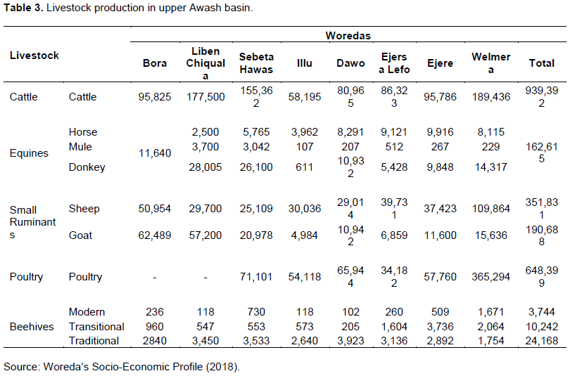
In the basin, there are about 939,392 cattle, 351,831 sheep, 190,688 goats, and 162,615 equines (Table 3). The communities mostly practice mixed farming system and thus use both agriculture and livestock productions for their income generation. They use energy from wood (mainly from eucalyptus), dried animal manures, and crop residues.
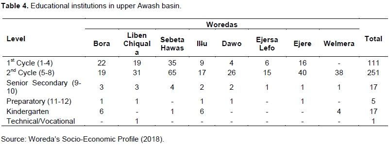
There exist 2 hospitals, 18 health centers, 66 health posts, 36 clinics, 19 rural drug shops and 7 pharmacies. In the basin, 17 kindergartens, 362 primary schools, 17 secondary schools, 5 preparatory schools and 1 TVET schools are also found (Table 4). The study also revealed that social infrastructures such as road crossing structures, bridges, cattle trough, water points, and foot paths are not well developed in the basin.
Environmental situation of upper Awash basin
Environmental assessment helps to examine the current environmental situation of the basin and thus enhances to formulate sound environmental management and planning strategies while keep raising the development of the community. In line with this, the study assessed the environmental situation of upper Awash basin through field visit, observation, and interviews. The assessment includes topography, climate, temperature, rainfall, regional geology, soil type, water resource, land use-land cover, vegetation, and wildlife of the basin.
The upper Awash basin has an elevation difference from 3500 to 1500 m. It has undulating plain with 41.2% followed by flat (24.3%) and rolling (18.9%) landforms (Figure 4). Steep hills and very steep mountains covered about 3.6 and 0.8% of the watershed, respectively. Undulating and rolling plains are spatially distributed in the lower portion of the basin whereas steep hills and very steep landforms are found in the middle and upper parts. These situations aggravate the overland flow speed as well as trigger flooding and consequently erosion. As a result, the overland flow is accumulated in middle part of the basin (that is at Ilu, Sebeta Hawasa, Liben Chiquala, and Bora woredas) which has relatively flat terrain.
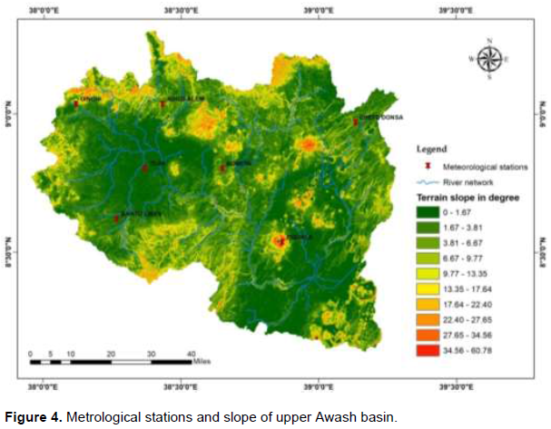
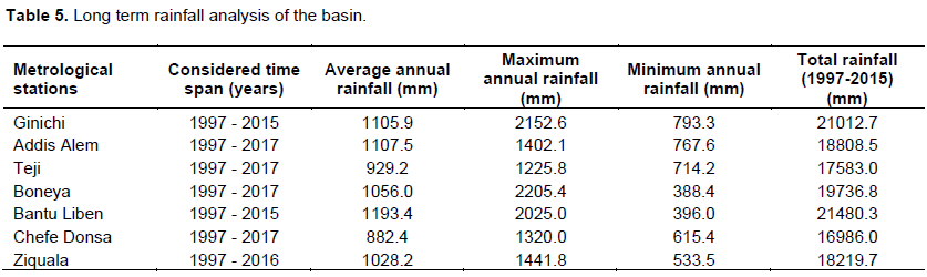
Moreover, the long term rainfall distribution of the basin has been examined. Measured rainfall data from seven metrological stations were collected (Figure 4) and the time span between 1997 and 2017 was considered for the analysis. The analysis showed that the basin receives a maximum of about 2200 mm rainfall annually while a minimum of about 400 mm rain per annum. Areas near by Ginichi, Boneya, and Bantu Liben metrological stations receive high amount of rainfall (Table 5) which enhance more overland flow and favors for the accumulation of large amount of excess rain at the low lands/flat terrain.
The basin situated in afro-tropical highland having wetland systems such as Becho plain areas and Lake Ellen. It has bimodal rainy seasons from June to September where the basin receives the highest rainfall of the year and from March to April with moderate rainfall intensity. The basin has various agro-ecological classes such as moist Wurch, moist Dega, wet upper Dega, dry Dega, moist Weina Dega, wet Weina Dega and dry Weina Dega. The mean annual temperature ranges from 20.8 to 29°C.
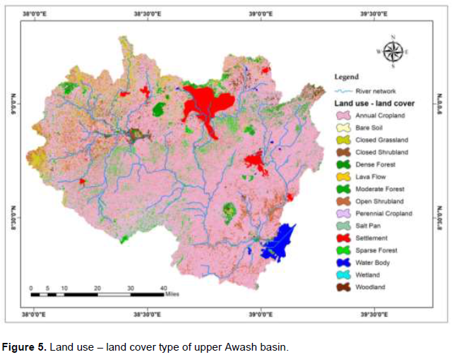
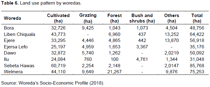
Cultivation is highly practiced in hilly and mountain landforms covering 70% of the watershed while 11.4 and 10.2% of the watershed is covered by open shrub land and forest, respectively (Figure 5 and Table 6). Pellicvertisols is the dominant soil type sharing 47.7% followed by Verticcambisols (12.6%) and Luvicphaeozems (7.2%). The average sediment yield was estimated as 1.7 million m3 per year while 12.8% of the watershed categorized under high and very high soil loss classes (that is, with soil loss rate above 50 t/ha/year). Crop production has been practiced in hilly and mountain landforms. Areas with high soil loss class are mostly found in Dawo and Ejere woredas. Poor land use management, overgrazing, and increment of rainfall intensity are the main factors for high sediment loss as well as flooding in the basin.
Based on woredas’ Water, Mines and Irrigation Office data, the mean water supply is very low. The communities get their water supply from protected springs, hand pumps, and shallow and deep wells. There are also expansions of farmland and grazing land in the basin, which potentially destroyed wildlife habitat. Despite, in the basin, there are still significant number and diversity of wildlife species in the area such as fox, ape, monkey, dikula, antelope, warthog and rabbit.
Flood impacts in the basin
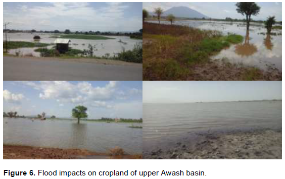
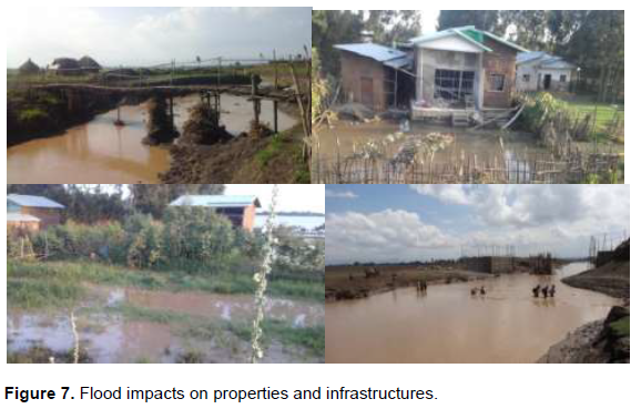
Flooding has been a critical problem in upper Awash basin and its frequency and extent are increasing from time to time. In the basin, flooding has frequently occurred at Ilu, Sebeta Hawasa, Wolmera, Liben Chiquala and Bora woredas (Figures 6 and 7). For instance, in 2017, 2018, and 2019 at Ilu, Sebeta Hawas, Wolmera and Egeria woredas; in 2014, 2016, and 2017 at Liben Chiquala and Bora woredas; and in 2012, 2015, and 2017 at Fentale.
Various studies have been performed examining flood vulnerability, flood frequency and risk assessment, and flood forecast of the basin (Dessu et al., 2016; Getahun and Gebre, 2015; Dawit, 2015; Mulu et al., n.p; Tadesse et al., 2016). Mulu et al. (n.p) examined flood vulnerabilityof upper Awash basin applying different approaches and determined flood hazard and risk map of the basin. The paper also showed that the assessment results match well with manually collected flood marks. It clearly showed that Ilu, Sebeta Hawasa, at the upstream and Bora and Liben-Chiquala at the downstream of upper Awash river are more likely exposed to the recurrent flood. Dawit (2015) particularly analyzed flood risk at Ilu flood plain. Tadesse et al. (2016) examined and showed flood frequency of the upper Awash basin by identifying appropriate procedure and considering measured stream flow data.
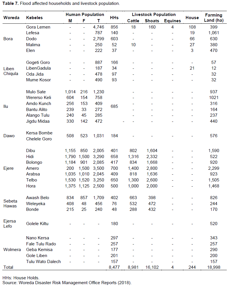
As mentioned, about 70% of the upper Awash basin is used for agriculture production and mostly practiced at hilly and mountain areas. Besides climate change (that is, increase of rainfall intensity), land use change (that is, increase of agricultural production and grazing land) aggravates flooding at the downstream and soil erosion at the upstream. Thus, relatively flat terrains like Ilu, Sebeta Hawasa, Bora, and Liben Chiquala woredas are more vulnerable to flood events. Flood affected households and livestock population of the basin are summarized in Table 7.
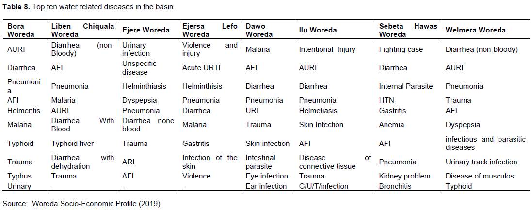
In addition, educational institutions in the upper Awash river basin often started late because of the flooding and health centers are not functional in the rainy season of the country. Existing roads and infrastructures were damaged with the recurrent flood. Flooding in the basin also caused water spreading disease. Top ten water related disease in the basin are summarized in Table 8. The communities also mentioned that the water abstraction wells are always flooded during rainy season and thus they are highly vulnerable to flood caused disease.
The need of integrated flood management approach
Integrated Flood Management approach addresses and integrates legal and institutional aspects, social and stakeholders’ involvement, environmental aspects, and also economic aspects besides flood risk assessment and/or flood forecasting system development (Figure 8).
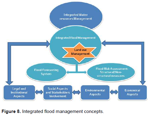
It also deals with land use management strategies. Consequently, works in shaping, developing, identifying and implementing optimal flood management solutions and strategies along with monitoring and evaluation options.
As stated earlier, the upper Awash river basin has its own social, economic and environmental status and has implemented unique legislation rules, that is, under laws and rules of the country, Ethiopia. The basin accommodates hundred thousands of human beings and livestock populations. And, it has various vegetation, wildlife, and water and natural resources. It comprises different developmental structures and infrastructures. Therefore, taking into account all these aspect, while developing flood management option, will enhance to achieve sustainable and optimal solutions.
Stakeholder involvement is very vital on developing IFM approach. Thus, potential stakeholders which shall be addressed to develop IFM mechanisms for upper Awash river basin are:
(1) Government offices (Awash Basin Developmental Office, Ministry of Water, Irrigation and Electricity of Ethiopia and Legislation offices),
(2) Government disaster management institutions (National Disaster Risk Management Commission and Woreda’s Disaster Risk Management Office), (3) Flood prone communities such as the communities lived in west Shoa zone (Ejere, Ejersa Lefo and Welmera), south west Shoa zone (Illu and Dawo), surrounding of Addis Ababa special zone (Sebeta Hawas) and east Shoa zone (Liben Chiquala and Bora) up to immediate upstream of Koka Dam,
(4) Scientific institutes or organizations such as school and health institutions, and
(5) Reregistered non-governmental organizations/ private sectors (Luna Farm Export Slaughter House Plc and Red Fox Flower industries).
Depending on the level of interest and influence of aforementioned stakeholders, they were informed, consulted and involved accordingly. Awash Basin Developmental Office was informed, communicated and consulted as the office is the owner of upper Awash integrated flood management project. The rest governmental and non-governmental offices, flood prone communities, and scientific institutions were informed, interviewed, and consulted accordingly as their input highly influence the socio-economic and environmental baselines of the basin and thus flood mitigations measures output. As a result, the flood management options provider party of Figure 8 (that is, flood forecaster/risk analyzer and mitigation developer) had information in one-way and/or two-way by receiving ideas and comments, as well as through delegation in decision-making process of concerned stakeholders. This built a consensus and stakeholders commitment.
Moreover, identifying the potential and extent of the stakeholders’ involvement for the implementation of integrated flood management approach is also essential so that the related cost and sustainability of flood mitigation/management options can be distinguished. In upper Awash river basin, the government through Awash Basin Developmental Office deals with budget requirement. The national and woredas' disaster risk management offices are aware of the scientific researches output regarding to flooding risk in the basin and perform research in order to identify flooding risk at the basin. Thereby, flooding risk in the basin can be minimized or prevented. The communities are willing to potentially participate on watershed development tasks (that is, soil and land conservation) as well as to cooperate on the implementation flood management options. In UARB, the communities were very happy while they heard about the integrated flood management project and showed their willingness to participate in any aspect. The scientific institutions shall participate on creating awareness on the need of integrated solutions and thus on implementation of integrated flood management mechanisms.
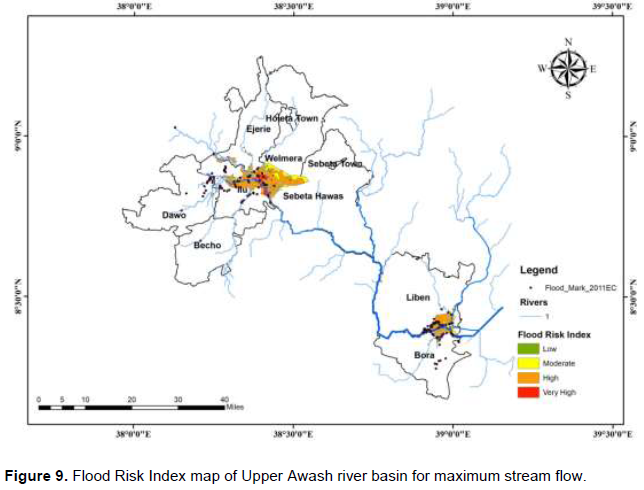
These detail assessment on social, economical and environmental status of the basin as well as identifying historical flood impacts in the basin were one of the majors input for upper Awash integrated flood management project thence were used to plan and develop integrated flood management options for the basin. The socio-economic and environmental assessments were used as essential inputs for determining flood risk map of the basin. For instance, the distribution of population density and land use-land cover type (that is, grazing, farming, infrastructures, or others) was combined with hydrodynamic study results and consecutively flood risk map was produced (Figure 9). This flood risk map is important to determine appropriate flood risk management mechanisms.
It is very vital to take into account social, economical and environmental aspects while developing flood risk and hazard map of a basin. It enhances for feasible and environmental friendly flood mitigation measures. It also supports decision making process.
Overall, probable flood mitigation measures shall consider the social, economic and environmental perspectives. And, their pro and cons shall be identified before implementation and they shall be optimized in order to maximize the benefits delivered. This will also ensure equity of among upstream and downstream communities of the basin and guarantee the sustainability of the proposed flood management options.
CONCLUSIONS
Flooding has been a critical problem in the upper Awash river basin resulting thousands of people being affected and huge economical loss was recorded. As mentioned, in west Shoa zone of Oromia region, Ethiopia, flood usually affects Sebeta Hawas, Ilu, Wolmera, Egeria, Liben Chiquala, and Bora woredas. The flood event has been aggravated from year to year. Thus, there is a need for integrated and sustainable flood management solutions. Consequently, this study emphasized the need of integrated flood management approach and its implementation in upper Awash basin for achieving sustainable solution.
The study selected the concerned parties/stakeholders that shall be considered for IFM and examined the basin socio-economic and environmental aspects as well as flood impacts. As a result, it assessed that the basin has about 855,391 populations where 94% lived in rural areas. There exist different types of vegetation, wildlife, and water and natural resources. It comprises different developmental structures and infrastructures. Agricultural and livestock productions are the dominant livelihood systems practiced in the basin. The study also examined the current educational institution distribution compared with the number of student in the study area. It discovered that the existing education institutions are not balanced with the school age population in majority of the woredas.
Moreover, the schools were deteriorated with the recurrent flood and often started late until it became dry and cleaned from the siltation. The communities mentioned that flooding is becoming a critical problem in the educational service of the area. Health centers and health posts are not functional during the rainy seasons. Health institutions are flooded and medicine and medical instrument damaged in every year. Contaminated diseases are increased due to the toilet filled by the flood. Pregnant women are unable to access health institutions. The communities are highly exposed to water related diseases such as malaria, diarrhea, and skin infection. Woredas and kebeles are connected with gravel road where their status is declining from time to time due the occurrence of recurrent flood in the basin.
Thereafter, the study combined the existing social, economical, and environmental information of the basin with hydrodynamic studies (that is, hydrodynamic modelling and flood vulnerability assessment) and then determined flood risk map of upper Awash river basin which further enhances for achieving sustainable flood management options.
CONFLICT OF INTERESTS
The authors have not declared any conflict of interests.
ACKNOWLEDGMENTS
This research was funded by Ethiopian Construction Design and Supervision Works Corporation and was performed under Feasibility Study and Detail Design of Upper Awash Integrated Flood Management Project. Thus, the authors would like to acknowledge Awash Basin Developmental office as well as the National and Woredas Disaster and Risk Management Commissions. They also thank the communities and administrative officials of upper Awash basin for their collaboration, concern and support during data collection process.
REFERENCES
|
Ballesteros-Cánovas JA, Sanchez-Silva M, Bodoque JM, Díez-Herrero A (2013). An Integrated Approach to Flood Risk Management: A Case Study of Navaluenga (Central Spain). Water Resource Management 27:3051-3069. |
|
|
Brears R (2015). Integrated Flood Risk Management in India and the South Asia Region: Lessons from the Rhine and Danube. NFG Research Group "Asian Perceptions of the EU", Freie University, Berlin, Germany. NFG Policy Paper Series No. 08. |
|
|
Central Statistical Agency (CSA) (2013). Population Projections for Ethiopia 2007 - 2037 Central Statistical Agency of Federal Democratic Republic of Ethiopia. |
|
|
Chawla I, Mujumdar PP (2015). Isolating the impacts of land use and climate change on streamflow. Hydrology Earth System Science19:3633-3651. |
|
|
CRED's Emergency Events Database (EM-DAT) (2019). |
|
|
Dawit S (2015). Flood Risk Analysis in Ilu Floodplain, Upper Awash River Basin, Ethiopia. MSc thesis. |
|
|
Dessu SB, Seid AH, Abiy AZ, Melesse AM (2016). Flood Forecasting and Stream Flow Simulation of the Upper Awash River Basin, Ethiopia Using Geospatial Stream Flow Model (GeoSFM). In Melesse, Abtew W (eds) Landscape Dynamics, Soils and Hydrological Processes in Varied Climates, Springer Geography pp 367-384. |
|
|
Didovetsa I, Krysanov V, Bürgera G, Snizhkoc S, Balabukh V, Bronsterta A (2019). Climate change impact on regional floods in the Carpathian region. Journal of Hydrology - Regional Studies 22. |
|
|
Getahun YS, Gebre SL (2015). Flood Hazard Assessment and Mapping of Flood Inundation Area of the Awash River Basin in Ethiopia using GIS and HEC-GeoRAS/HEC-RAS Model. Journal of Civil Environment Engineering 5(4). |
|
|
Grabs W, Tyagi AC, Hyodo M (2007). Integrated flood management. Water Science Technology 56(4):97-103. |
|
|
Hettiarachchi S, Wasko C, Sharma A (2018). Increase in flood risk resulting from climate change in a developed urban watershed - the role of storm temporal patterns. Hydrology Earth System Science 22:2041-2056. |
|
|
Intergovernmental Panel on Climate Change (IPCC) (2007). Summary for Policymakers of the AR4 Synthesis Report: Climate Change 2007. This summary approved in detail at IPCC Plenary XXVII, Valencia, Spain. |
|
|
James A, Lecce SA (2013). Impacts of Land-Use and Land-Cover Change on River Systems. In Book Treatise on Geomorphology: Shroder J, Wohl E (2013): Academic Press 9:768-793. |
|
|
Maghsood FF, Moradi H, Bavani ARM, Panahi M, Berndtsson R, Hashemi H (2019). Climate Change Impact on Flood Frequency and Source Area in Northern Iran under CMIP5 Scenarios. Water, 11:273. |
|
|
Mulu T, Mitiku AB, Tadesse A (unpublished). Assessing Flood Vulnerability of upper Awash Basin using AHP Method and Sensitivity Analysis. |
|
|
National Disaster Risk Management Commission (NDRMC) (2016). 2016 Belg National Flood Contingency Plan of Ethiopia. |
|
|
Rogger M, Agnoletti M, Alaoui A, Bathurst JC, Bodner G, Borga M, Chaplot, V, Gallart F, Glatzel G, Hall J, Holden J, Holko L, Horn R, Kiss A, Kohnova S, Leitinger G, Lennartz B, Parajka J, Perdigao R, Peth S, Plavcov L, Quinton JN, Robinson M, Salinas JL, Santoro A, Szolgay J, Tron S, van den Akker JJH, Viglione A, Bloschl G (2017). Land use change impacts on floods at the catchment scale: Challenges and opportunities for future research. Water Resource Research 53:5209-5219. |
|
|
Sen Z (2018). Climate Change Impact on Floods. In Flood Modeling, Prediction and Mitigation pp 337-379. |
|
|
Tadesse L, Sonbol MA, Willems P (2016). At-Site and Regional Flood Frequency Analysis of the Upper Awash Sub - Basin in the Ethiopian Plateau. |
|
|
Topalovic Z, Markovic D (2018). Integrated Approach to Flood Management. KALBS Integrated urban planning pp 143-169. |
|
|
United Nation (UN) (2015). The Human Cost of weather Related Disasters 1995 - 2015. Center for Research on Epidemiology of Disaster (CRED) and UN Office for Disaster Risk Reduction (UNISDR). |
|
|
Verburg PH, Koomen E, Hilferink M, Perez-Soba M, Lesschen JP (2012). An assessment of the impact of climate adaptation measures to reduce flood risk on ecosystem services. Landscape Ecology 27:473-486. |
|
|
World Meteorological Organization (WMO) (2006a). Social Aspects and Stakeholder Involvement in Integrated Flood Management. Geneva: World Meteorological Organization. ISBN: 92-63-11008-5. |
|
|
World Meteorological Organization (WMO) (2006b). Environmental Aspects of Integrated Flood Management. Geneva: World Meteorological Organization. ISBN: 92-63-11009-3. |
|
|
World Meteorological Organization (WMO) (2007). Economic Aspects of Integrated Flood Management. Geneva: World Meteorological Organization. ISBN:92-63-11010-07. |
|
|
World Meteorological Organization (WMO) (2009). Integrated Flood Management Concept Paper. Geneva: World Meteorological Organization ISBN 978-92-63-11047-3. |
|
|
World Meteorological Organization (WMO) (2017). Selecting Measures and Designing Strategies for Integrated Flood Management. Geneva: World Meteorological Organization. |
|
|
Wu L, Xu Y, Yuan J, Xu Yu, Wang Q, Xu x, Wen H (2018). Impacts of Land Use Change on River Systems for a River Network Plain. Water 10:60. |
|
|
Zlatanovaa S, Ghawanab T, Kaurb A, Neuvelc JMM (2014). Integrated Food Disaster Management and Spatial Information: Case Studies of Netherlands and India. Proceedings of The International Archives of the Photogrammetry, Remote Sensing and Spatial Information Sciences VIII Symposium, India. |
|
Copyright © 2024 Author(s) retain the copyright of this article.
This article is published under the terms of the Creative Commons Attribution License 4.0


