
ABSTRACT
The classification of the sediments into facies and the various environments in which the sediments of the northeastern Voltaian basin were deposited has not been clearly described. Using detailed field mapping together with petrographic studies, six sedimentary facies has been identified; F1 is defined by asymmetric wave formed ripple marks, F2 indicates flute casts on micaceous sandy shales, F3 has bifurcated ripple and climbing ripple marks on argillaceous materials at the middle parts of the scarp, F4 is identified by parallel and cross stratifications observed close to the upper parts of the scarp, F5 has a bipolar herringbone cross beds and planar cross beds on quartz rich sediments at the southern parts of the study area and a distinctive well developed burrows (Skolithos) at the southern half of the study area defines facies F6. The sediments are deposited largely in a shallow marine environment, with subordinate fluvial, flood plain, deltaic, aeolian, tidal flats and shoreface/nearshore environments. Although, there exist a suitable depositional environment for the formation of hydrocarbons, the overlying sediments are not thick enough to give the required temperature and pressure conditions for hydrocarbons development in the northeastern fringes of the basin. Paleosol features evident by pseudokarren, like weathering marking the contact between the middle Oti/Pendjari group and the lower Gambaga group of the study area. The sequence of the area is that of a typical shallowing, thickening and coarsening upward sequence.
Key words: Clastic sediments, environments, facies sequence, Gambaga-Nakpanduri, massifs.
INTRODUCTION
The northeastern Voltaian basin, of the Gambaga-Nakpanduri areas overlies the basement rocks in the northeastern parts of the basin. Bombouaka group in Togo is largely accepted as the lateral equivalence of the Kwahu group of Ghana (Affaton et al., 1980), studies in its Togo extension reveals that the 500 m thick sedimentary strata of the Bombouaka group was deposited in fluvial, deltaic and nearshore or foreshore environments (Carney et al., 2010; Affaton et al., 1980). The Gambaga-Nakpanduri area of the northeastern Volta basin of Ghana is the lateral equivalence of the southeastern Kwahu group. This makes it understandable if we refer to the northeastern areas of the basin as Bombouaka/Gambaga group. The area for it well exposed outcrops has seen some amount of work done on significant parts of it allowing age (Akah, 2008) to be given to these sediments as well as geochemical studies leading to the various discussion on the climatic conditions, the weathering conditions, source and tectonic setting (Viljeon et al., 2008).
Recently, Anani et al. (2017) carried out provenance studies on the Gambaga-Nakpanduri areas arriving at various conclusions on the area. The Voltaian basin has been reported (Bozkho et al., 1971) to have indications of oil shows, this has not, however, seen any formal studies on the basin towards the identification of the possible source rock or reservoir rock for this hydrocarbon shows. Notwithstanding the wealth of primary data and information studying and analyzing the facies of the basin can provide on the depositional environment and processes, the 460 to 500 m thick well exposed sedimentary sequence has since not been considered for sedimentological studies with facies analysis as the main focus of the study. In this study of the Gambaga-Nakpanduri areas of the northeastern fringe of the Voltaian, for the first time, the author seeks to analyze the facies and the depositional processes and environment of the sediments, as this will help reveal how suitable the prevailing depositional environments are to hosting source and/reservoir rocks of the oil shows in the basin and to developed a facies sequence for the area.
Location and geological setting
Location
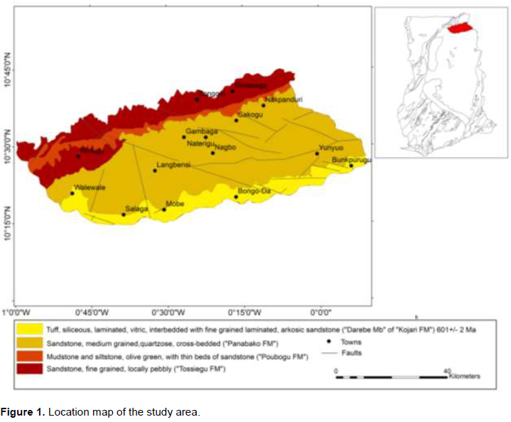
The study area is located in the northeastern most parts of the Volta basin, overlying the crystalline basement rocks of the Birimian Supergroup. The Gambaga-Nakpanduri scarp (Figure 1) to the northeastern parts of the basin is characteristically of sandstones, shales and siltstones defining a broad flat lying topography. The study area is approximately 90 km southeast of Bolgatanga, the regional capital of the Upper East Region and connected by feeder roads. The roads connecting Gambaga-Nalerigu and Nakpanduri-Bimbago are however tarred with chippings. The study area is generally motorable during the dry season using a motorbike and pick-up in some cases. This area is generally of savanna grassland that is mostly swept by bushfires during the dry season. The area has well exposed outcrops with well-developed and varied sedimentary features relative to its southeastern Kwahu group equivalence, making the area a suitable location for the study.
Geological settings
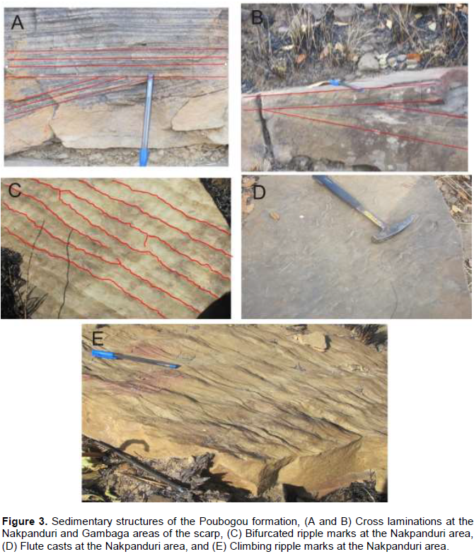
The Bombouaka/Gambaga/Kwahu group represents the older lower lithostratigraphic unit of the basin and shows epicontinental characteristics. It consists of three disconformable subdivisions which are well presented in northern Togo as Dapaong, Fosse-aux-Lions and Yemboure groups (Deynoux et al., 2006). The lower Tossiegou formation (Affaton et al., 1980) overlies the basement crystalline rocks in the north (Figure 1) and this formation dips southwards taking it beneath the Poubogou formation (Carney et al., 2010). The formation is characterized by quartzitic sandstones with micaceous sandstone records in some of its exposures with ripple marks features. It is exposed within the Morago River at the base of the scarp at the Nakpanduri areas. This is considered to be the lateral correlation of the Yabraso sandstone formation in the southeastern areas (Carney et al., 2010). The Poubogou formation of the Bombouaka group overlies the Tossiegou formation and composed of micaceous shales, sandy shales, siltstones at the base of the Nakpanduri areas (Carney et al., 2010; Ayite et al., 2008) and in the Gambaga areas. The shales/sandy shales are with characteristic papery fissility (Ayite et al., 2008). According to Carney et al. (2010), the Poubogou formation appears to pinch out in the Larabanga area describing a wedge-shape of the formation; this is coupled with thin bedded sandstones with planar cross beds according to Ayite et al. (2008). The formation has cross-stratifications at its Nakpanduri and Gambaga areas, flutes casts, climbing ripple marks and bifurcated ripple marks at the Nakpanduri areas. Ayite et al. (2008) grouping the formation as “Lower Nakpanduri formation” observed ball and pillow structures as well as flute casts and cross-beds. The Panabako formation exposed in the northeastern areas is largely composed of quartzitic and feldspathic sandstones (Viljeon et al., 2008; Carney et al., 2010; Akah, 2008). These sandstones have relatively thick bedding in some areas characterized by cross-beds
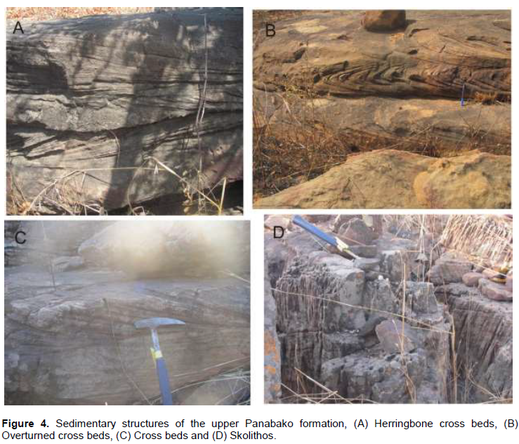
with dips of cross beds in the excess of 35 to 40°, that is, suggesting aeolian sediments, ripple marks (symmetric and asymmetric) and herringbone cross-beds (Viljeon et al., 2008). The area has soft sediments deformational structures-slump folds and overturned cross beds in the Gambaga-Nakpanduri areas. Burrows are ubiquitous on the formation in the study area and has been reported to be evidence of trace fossils particularly Skolithos as they are penetrative in cross sections of the exposure (Viljeon et al., 2008).
METHODOLOGY
A detail field mapping was undertaken on a scale of 1:50000. Lithological description (macro and mesoscopic description), thus mineralogical composition, texture, color and petrographic studies of collected samples was carried out at the Earth Science Department, University of Ghana. The lithological association(s) at outcrop scale and measurements on the sedimentary structures therein, was recorded at each outcrop location using the handlens, dilute hydrochloric acid (to check the presence of carbonates), geological compass as well as tape measure and meter rule to measure structural attitudes of the sedimentary features and also to measure the thickness of bedding in the various outcrop locations. The Gambaga-Nakpanduri scarp which defines the northern half of the area was observed at three separate locations, at Nakpanduri, Sakogu and at Gambaga (about 210 km NNW of the Gambaga Township) areas where the scarp is well exposed and accessible for field observation and measurement of outcrop features. The southern half of the study area which is part of the Gambaga Group though not exposed on the scarp, has well exposed outcrops with well-developed sedimentary structures, and were critically observed and their grain and matrix proportion compared using visual percentage classification chart. Outcrops were observed at twenty seven localities and were mesoscopically studied and samples subsequently collected for microscopic studies. The textures of the sandstones were classified in the field using the Wentworth scale together with the hand lens. Dilute hydrochloric acid was used in the field to confirm the presence or absence of carbonate minerals. The measurement of the bed thickness, wave length and height of the ripple marks were done using a measuring tape and meter rule in the field. The facies and depositional environment analysis were carried out considering the compositional, textural and sedimentary structures and subsequently the facies sequence constructed using CoralDRAW×4.
RESULTS AND DISCUSSION
Sedimentary facies
Sedimentary facies are the products of the environments in which they are found and depositional environment of sediments is usually characterized by certain sedimentary structure(s) which defines the type of sedimentary facies. The interpretation of facies can be by considering the depositional environments, processes and the prevailing conditions at the time of deposition. Different energy levels of the depositional media could reflect variable sedimentary facies as the sedimentary structures will be different with a possible similar composition of the sediments, hence, the grouping of the sediments into facies is principally based on the observed sedimentary structures, which reflects the depositional environments, conditions and processes, the composition and the texture of the sediments (Tucker, 2004; Kavoosi et al., 2009).
Facies 1
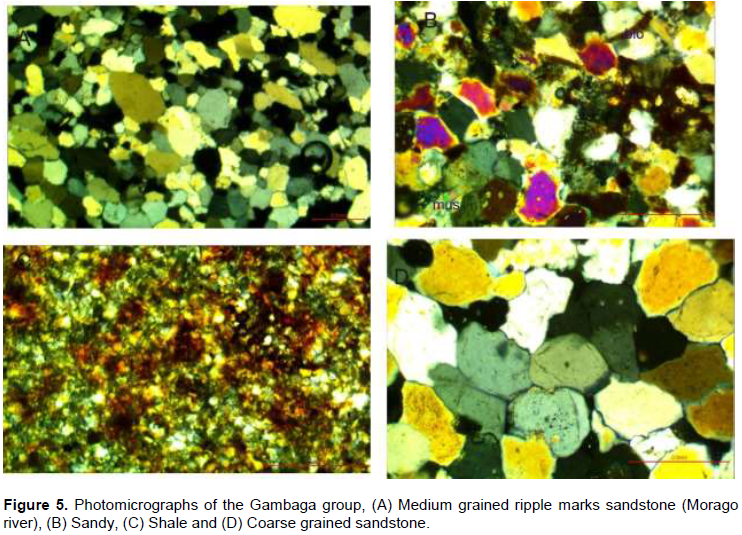
Sandstone with ripple marks were observed in the northeastern most part of the study area within the Morago River which is at the base of the Nakpanduri scarp (Figure 2A), the surface was however masked with mud. The sandstone is thinly bedded with bed thickness ranging between 1.5 and 3 cm, the ripple marks on these sandstones have stoss and lee sides dips of 11° NE and 15° SW, respectively, with wave length (L) and height (H) measured to be 10 and 1.5 cm, respectively, giving a calculated ripple index (RI = L/H) of 6.7. It is characterized by fine-medium grained (Figure 5A), pinkish-brown in color containing quartz, feldspars and muscovite.
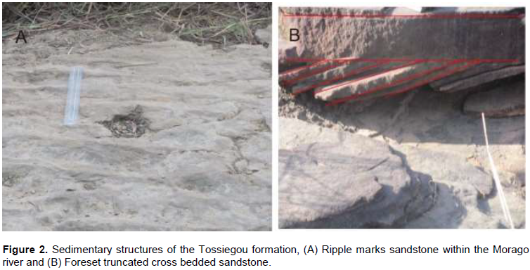
This describes F1 facies (Figure 6). Wave formed ripples are generally symmetric ripples, however, gentle stoss-side dip of 11° NE with steep lee-side dip of 15° SW suggests an asymmetric ripple marks. This indicates that the ripple marks were as a result of variable strength of wave in different direction. The wavelength of ripple marks are controlled by the grain size and depth of water, larger wavelength are produced from deeper depths and coarser sediments (Tucker, 2004). The presence of wave formed ripple marks with RI of 6.7 (Figure 2A) and a medium grain size sediments suggest a possible shallow marine environment of shelf setting, a beach environment of deposition cannot however, be precluded. A fluvial environment of deposition is reported by Ayite et al. (2008) for the immature Shishie sandstone which is the equivalence of this facies of the current study.
Facies 2
At the Nakpanduri area, the middle part of the scarp is largely sandy shales. These have observable flute casts (Figure 3D) on the surfaces of boulders and floats (generated from the frequent rock fall from the top of the scarp). These are with greenish-grey and shiny dark-brown smooth surfaces; they are micaceous with both biotite and muscovite under the microscope (Figure 5B) and fine grained describing the F2 facies (Figure 6). The presence of flute casts on sandy shales suggests the action of eddies under turbulence over argillaceous material, which is an evident of a high energy current. The micaceous sediments with both biotite and muscovite are an indication of the deposition of these facies in a fluvial environment by a high energy medium. Ayite et al. (2008) also reported a high energy medium for the sediments at the lower parts of Nakpanduri.
Facies 3
Peculiar with the Nakpanduri area of the scarp are greenish-grey, micaceous and fine grained sandy shales. They are with climbing ripples (Figure 3E) and bifurcated ripple marks (Figure 3C) without observable laminations on outcrop scale. These sedimentary features are on silt/sandy shales of F3 facies type of the facies sequence (Figure 6). Sediments when deposited rapidly from sediment-laden current can give rise to the formation of climbing ripple marks in a shallow marine environment (Tucker, 2004; Dorrik and Stow, 2005) by a low energy medium. The presence of straight crested bifurcated ripple marks on argillaceous materials (Figure 5C) suggests the dominance of wave action over current in a fluvial environment.
Facies 4
Characterizing the top parts of the Nakpanduri and Gambaga areas of the scarp are greenish-grey micaceous and moderately weathered sandy shales, they appear massive on outcrop scale with a papery fissility (<1 mm partings). They have parallel laminations as well as cross-stratifications defining F4 facies (Figure 5). There are foresets and topsets truncations on sandy shales (Figure 3A and B) in the Nakpanduri and Gambaga areas, respectively. The truncation of the sets indicates the current directions. Micaceous sandy shales with both parallel and cross lamination indicate a possible standing water medium of a possible fluvial setting. Fluvial environments are suggested by Haruna et al. (2013) for shales with both ripple marks and cross lamination. Hossain et al. (2002) also reported flood plain environments for shales with characteristics of parallel lamination.
Facies 5
To the northeast of Nakpanduri, close to Duklotku and at the outskirts of Sakogu defines F5 facies. This is almost quartz in mesoscopic scale (Figure 5D), medium-coarse grained and whitish colored due to authigenic quartz overgrowth. It is characterized by herringbone cross-beds (Figure 4A) and over turned cross-beds (Figure 4B) with bed thickness between 2 and 5 cm. They have planar cross-beds (Figure 4C) with thickness of bedding ranging from 1.5 to 5 cm. The heights of deposited sediments are in the range of 25 to 30 m in some areas. Bipolar cross beds like herringbone cross beds are indicative of reversal tidal currents (Tucker, 2004). These sandstone facies which are quartz rich and coarse grained with relatively thicker beds are possibly deposited by tidal flats/tidal currents, aeolian environments can, however, not be precluded (Asiedu et al., 2005). A shifting coastal environment and tidal flats environments are also reported by Viljeon et al. (2008) for these sediments.
Facies 6
Southern parts of the study area are dominated by quartzitic and arkosic sandstones, medium-coarse grained and whitish resulting from authegenic quartz overgrowth, have well-developed burrows which destroys the bedding of this group of sandstones and associated cross-bedding and wavy laminations in isolated areas defining facies F6 (Figure 6). The burrows are without sediments in-filling and are penetrative in cross-section indicating Skolithos (Figure 6D). The beds thicknesses are between 1 and 1.5 cm at some areas. The presence of burrows without sediment filling supports their development in consolidated sediments. The evidence of their intense bioturbation reflects low/break in sedimentation rate according to Kavoosi et al. (2009), moderate sediment supply rate is also reported by Odumoso et al. (2013) and this is indicative of sediments of foreshore/shoreface environments. The presence of wavy laminations with relatively high feldspar content supports sediments deposition under turbulence in a continental shelf environment. A tidal flat and deltaic environment where the sediment supply is fluctuating with some current-wave activity is possible. Anani et al. (2013) also reported a rapid deposition of sediments in a fluvial environment for sediments with such features. Viljeon et al. (2008) also reported tidal flats, aeolian and deltaic environments for the Panabako formation, of which this class of facies of this study belong.
Affaton et al. (1980), looking at the Bombouaka lower group in parts of Togo, reported fluvial, deltaic and nearshore or shoreface environments for the sediments of the Bombouaka group. Carney et al. (2010) also reported a possible fluviatile or deltaic environment for the southeastern sediments. The middle Poubogou formation of the Gambaga group of the northeastern Voltaian basin has been identified by facies 2, 3 and 4 with varied sedimentary features of both low and high energy media. The southern half of the area has well developed sedimentary structures on both feldspathic and quartzitic sandstones, representing the Panabako formation/upper part of the Gambaga group and defines the fifth and sixth classes of facies from the study.
Facies sequence of the Gambaga-Nakpanduri area
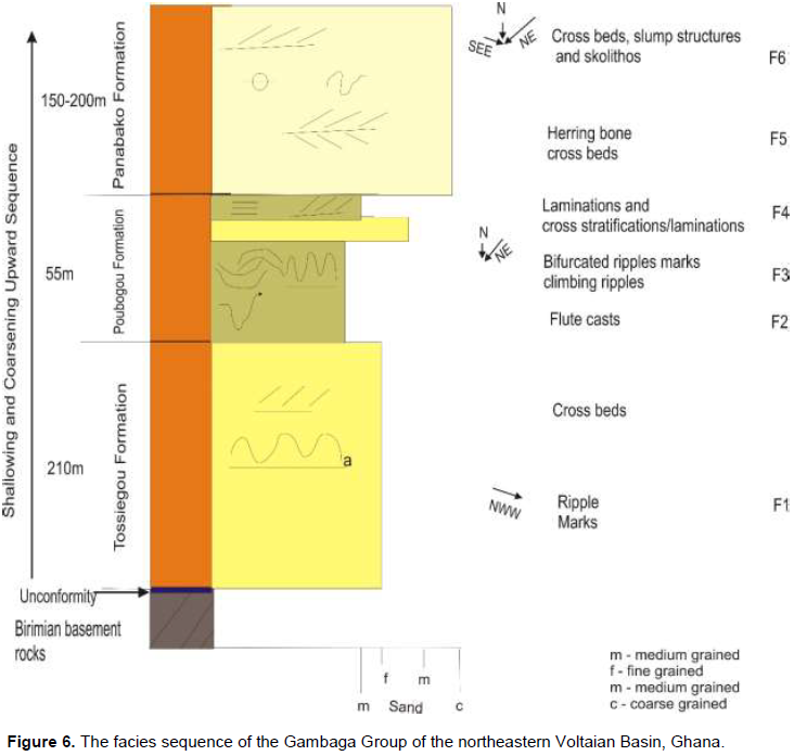
The facies sequence of the Gambaga group of the northeastern Voltaian basin is discussed based on the texture of the sediments and the observed sedimentary features within the study area. The thickness of the Gambaga group, according to Viljeon et al. (2008), is about 465 m thick with the lower Tossiegou formation being 210 m, whilst the middle Poubogou and upper Panabako formations being 55 and 150 to 200 m, respectively (Figure 6). The current study was not able to reveal any contacts between the formations within the group except paleosol evidence defined by pseudokarren-like weathering features marking the boundary between the lower Gambaga/Bombouaka/Kwahu group in the study area and the middle Oti/Pendjari group. The grain size of the sediments ranges from medium grained in the bottom part of the sequence to fine grain in the mid portions of the sequence and then medium to coarse grained sediments in the upper parts of the sequence. The area is characterized by various facies of sandstone, siltstone and shales with varied sedimentary structures (Figures 2, 3 and 4). The upper part of the sequence is distinct with well-developed burrows identified as Skolithos (Viljeon et al., 2008) as they are penetrative in cross section. The middle Poubogou formation of the studied area has step-like topography towards the lower Tossiegou formation. There is repetition of the lower sandstone component as an intercalation within the middle shale/silt/sandy shale formation of the area (Figure 6). The transition of siltstone onto shales and then to sandy shales and onto sandstones indicates a coarsening upwards sequence. The sequence of the studied area also supports an overall shallowing, thickening and coarsening upward sequence.
CONCLUSIONS
The study revealed significant information about the Gambaga group and the Voltaian basin as a whole, using parameters of depositional environments, depositional conditions and processes:
(1) Six sedimentary facies has been identified within variable depositional environments with a dominant shallow marine environment for the area.
(2) Deltaic, aeolian, flood plain, fluvial and tidal flats environments are the subordinate environments as well as shoreface/foreshore marine environment with presence of penetrative burrows (Skolithos) in cross section.
(3) Both low and high energy media are responsible for the deposition of the sediments reflected in the sedimentary features of the area.
(4) The thickness of the study area from early workers is about 465 m, although the fluvial environments observed from the study is suitable for the formation of hydrocarbons, the thickness of the 55 m with an overlying sandstone of about 200 m is not enough to generate the needed temperature-pressure conditions suitable for the conversion of organic material in the fluvial environments (if any) into hydrocarbon products.
(5) The source rock for the hydrocarbon shows will not be anywhere in the northeastern fringe of the basin, as the basin is very shallow at its northeastern ends, the source rock for the hydrocarbon indications is most likely to be at the central or southeastern ends where the basin is relatively thick with dominant argillaceous materials.
(6) There are no observed boundaries between the formations within the Bombouaka/Gambaga group during the study except for paleosol evidence, with the presence of pseudokarren-like weathering features marking the boundary between the Kwahu/Bombouaka/Gambaga group and that of the overlying Oti/Pendjari group.
(7) The facies sequence represents an overall shallowing, coarsening and thickening upward sequence.
CONFLICT OF INTERESTS
The author has not declared any conflict of interests.
ACKNOWLEDGEMENTS
The author’s sincere heart felt gratitude goes to the Departments of Earth Science, University of Ghana for the assistance in providing field logistics for this work. Thanks also go to Prof. Asiedu of the Earth Science Department, University of Ghana, for his assistance in drawing the facies sequence and three anonymous reviewers whose constructive comments helped refined the manuscript.
REFERENCES
|
Affaton P, Sougy J, Trompette R (1980). The tectono – stratigraphic relationships between theupper Precambrian and lower Paleozoic volta Basin and the Pan – African Dahomeyideorogenic belt West Africa. Am. J. Sci. 280:240-248. |
|
|
Akah AK (2008). Detrital zircon geochronology by LA-ICP-MS: Voltaian sediments from the Gambagaand Kintampo massifs. In: Kalsbeek, F. (Ed.), The Voltaian Basin, Ghana. Workshop and Excursion, March 10-17. Abstract Volume. Geological Survey of Denmark and Greenland (GEUS), Copenhagen. pp. 55-56. |
|
|
Anani C, Modupe M, David A, Jacob K, Daniel A, Daniel B (2013). Geochemistry and provenance of sandstones from Anyaboni and surrounding areas in the Voltaian basin, Ghana. Int. Res. J. Geol. Mining (IRJGM) (2276-6618). 3(6):206-212. |
|
|
Anani CY, Mahamuda A, Kwayisi D, Asiedu DK (2017). Provenance of sandstones from the Neoproterozoic Bombouaka Group of the Volta Basin, northeastern Ghana. Arab. J. Geosci. 10:465. |
|
|
Asiedu DK, Hegner E, Rocholl A, Atta-Peters D (2005). Provenance of late Ordovician to early Cretaceous sedimentary rocks from southern Ghana, as inferred from Nd isotopes and trace elements. Journal of African Earth Sciences 41:316-328. |
|
|
Ayite A, Awua F, Kalvig P (2008). Lithostratigraphy of theGambaga massif. Voltain Basin Workshop Excursion. 41-44. |
|
|
Bozhko NA, Kasakov GA, Trofimov DM, Knorre KG, Gatinski YUA (1971). New absolute dating of West African glauconites. Doklady Akademii Nauk SSSR 198:138-139. |
|
|
Carney JN, Jordan CJ, Thomas CW, Condon DJ, Kemp SJ, Duodo JA (2010). Lithostratigraphy, sedimentation and evolution of the Volta Basin in Ghana. Precambrian Res. 183:701-724. |
|
|
Deynoux M, Affaton F, Trompette R, Villeneuve M (2006). Pan – African evolution and glacial events registered in Neoproterozoic to Cambrian cratonic and foreland basins of West African. J. Afr. Earth Sci. 46:397-426. |
|
|
Dorrik A, Stow V (2005). Sedimentary rocks in the field. A colour guide.73 Corringham Road, London NW11 7DL, UK. |
|
|
Haruna IV, Dio CJ, Maunde A, Raji AS (2013). Provenance and Paleoenvironmental Study of Bima Sandstone in the Upper Benue trough, N.E., Nigeria. Int. Res. J. Earth Sci. 2321-2527. 1(2):1-11. |
|
|
Hossain HM, Zakir M, Sultan U, Syed SA, Ismail H (2002). Analysis of sedimentary faciesand depositional environments of the PermianGondwana sequencein borehole GDH-45, Khalaspir Basin, Bangladesh. Geosci. J. 6(3):227-236. |
|
|
Kalsbeek F, Frei D, Affaton P (2008). Detrital zircon ages from the Volta Basin and adjoiningPan-African thrust sheet in Ghana. |
|
|
Kavoosi MA, Lasemi Y, Sherkati S, Moussavi – Harami, R (2009). Facies Analysis and Depositional Sequence of the Upper Jurassic Mozduran Formation, A Carbonate Reservoirin the KopetDagh Basin, Ne Iran. J. Pet. Geol. 32(3):235-260. |
|
|
Odumoso SE, Oloto IN, Omoboriowo AO (2013). Sedimentological and Depositional Enviroment of the Mid-Maastritchtian Ajali Sandstone, Anambra Basin, Southern Nigeria. Int. J. Sci. Technol. P 3. |
|
|
Tucker ME (2004). Sedimentary rocks in the field. The geological field guide series, 3rdEd, West Sussex PO19 8SQ, England. |
|
|
Viljeon JH, Agyapong W, Le Berre W, Reddering JS, Thomas E, Atta–Ntim K (2008). Geology of sheet 1001D south of Gambaga. InThe Voltaian Basin, Ghana. Workshop and Excursion pp. 39-40. |
|
Copyright © 2024 Author(s) retain the copyright of this article.
This article is published under the terms of the Creative Commons Attribution License 4.0


