ABSTRACT
Geological mapping of the Gulani area revealed that the area consists of Precambrian Basement Complex rocks, Cretaceous sediments and the Tertiary/Quaternary basalts of the Biu plateau. The Basement Complex rocks are represented by diorite and granites while the sediments include the Bima, Yolde, and Pindiga Formations. Epigenetic baryte-copper mineralizations occur with the baryte veins restricted to the Bima and Yolde sandstones while the Copper mineralizations occur in granites. Petrographic study indicates that the diorite is largely composed of andesine plus hornblende and accessory quartz and iron oxide. The granites, on the other hand, consist essentially of quartz, microcline and orthoclase with minor biotite and iron oxide. The Bima and Yolde sandstones are composed of quartz, microcline, plagioclase and accessory biotite and opaque crystals. The large quartz and microcline crystals in both granites and sandstones are fractured. The Kanawa member of the Pindiga Formation is made up of shales interbedded with Limestones. The limestone interbeds are both crystalline and fossiliferous types. The basalts consist of labradorite laths, olivine, augite and opaques. Transmitted light petrography of the hydrothermally altered Bima and Yolde sandstones show the presence of quartz, baryte and microcline. The barite occurs as pore space in-filling mineral between the quartz and microcline and within the fractures of these brittle minerals. The Cu (chalcopyrite/malachite) mineralizations occur within highly fractured zones of the granites. Reflected light microscopy indicates that only relicts of the primary chalcopyrite exist while the veins/veinlets are now almost entirely occupied by the secondary mineral of malachite and its associated limonite which are the alteration products of the chalcopyrite.
Key words: Petrography, fractures, baryte-copper, mineralization, Gulani, Nigeria.
The study area lies within Gulani sheet 132 (1:100,000) and occupies the southern parts of Borno and Yobe States of Northeastern Nigeria. It is located in the northern part of Gongola Basin within the Upper Benue Trough (Figure 1). The area comprises of three major groups of rocks commonly found in northeastern Nigeria namely, Precambrian Basement Complex, Cretaceous Sediments and Tertiary/Quaternary volcanic rocks of the Biu Plateau. One of the earliest detailed geological work including stratigraphy, paleontology, structural aspects, economic geology and hydrogeology covering parts of Adamawa, Bauchi and Borno provinces was carried out by Carter et al. (1963).
In late 1980s through 1990s, the Basement Complex of northeastern Nigeria and to some extent the Cretaceous sediment in the region have been studied in respect of favourability, structural settings and geochemistry of uranium (U) mineralization (Oshin and Rahman, 1986; Maurin and Lancelot, 1990; Funtua et al., 1992; 1998; 1999; Okujeni and Funtua, 1994).
Numerous low grade uranium mineralizations occur within the Gubrunde horst (Basement Complex) and in the sedimentary rocks adjacent to Peta syncline. These include the Kanawa, Gubrunde, Zona, Adada and Dali occurrences (Funtua et al., 1992; Ogunleye and Okujeni, 1993). Other
U mineralizations include those of Ghumchi and Mika (Funtua et al., 1997, 1998; Dada and Suh, 2006).
The mineralizations commonly occur in fractured, sheared or brecciated zones of granites which are sometime in association with later rhyolites. These structures are mostly N – S and NE – SW trending and the mineralizations tend to occur at their intersections. Sulphides occurring as veins and disseminations within the granites and economic deposits of feldspar and quartz associated with Liga pegmatite have been reported around Gwoza area (Islam and Baba, 1990; Baba et al., 1991).
To some extent, various workers have studied the geology, stratigraphy, structure, paleogeography, petroleum and solid minerals associated with the Cretaceous and younger sediments of the Upper Benue Trough (Carter et al., 1963; Idowu and Ekweozor, 1989; Baba et al., 1995; Zaborski et al., 1997; El-Nafaty and El-Nafaty, 2000; Obaje et al., 2004). Mineral deposits hosted by sediments in the region include evaporates, diatomites, limestones, clays, coal and suphides among others.
Baryte have been reported in several places within the Benue Trough forming a metallogenetic belt extending from Abakaliki in the southwest of the Trough through Akwana, Arufu and Azara in the middle Benue Trough to Gwana and Gombe in the Upper Benue Trough (Farrington, 1952; Olade, 1976; Ford, 1989; Wright, 1989). El-Nafaty (2014) have recently documented the occurrence of baryte in Gulani area within the extreme northern part of the Gongola Basin of the Upper Benue Trough.
Detailed geological and petrographic investigations were lacking in the study area. Therefore, this study provides detailed geology and petrography of the rocks and the associated baryte-copper mineralizations through geological mapping on a scale of 1: 50,000 in order to locate all the rock units. This was followed by a thorough transmitted and reflected light microscopic study of the rocks and baryte-copper mineralizations in the study area.
Generally the geology of northeastern region consists of ancient (Precambrian) crystalline Basement Complex rocks represented mainly by granitic and migmatitic rocks, on which rest nonconformably the sedimentary and volcanic rocks ranging in age from Cretaceous to Quaternary (Carter et al., 1963) (Figure 1). The Basement Complex rocks are grouped into two; the magmatite-gnesis complex and the older granites.
Basement complex rocks
Migmatite – Gneiss Complex
The oldest rocks of the basement complex are made up of remnants of an ancient sedimentary series now almost entirely transformed into anatectic migmatites, gneisses and granites through migmatization and granitization processes. Relics of the metasediments are found only as xenoliths and small pendants in the granitic rocks. They are widely distributed but individual exposures are of few square metres (Carter et al., 1963). The metasediments include quartzo - feldspathic, biotite- and calc-silicate rocks. However, biotite and hornblende gneisses are amongst the most frequently occurring types. Mineral assemblages correspond to those of the amphibolite facies (Carter et al., 1963).
Older granites
The Pan-African Older Granite series in northeastern Nigeria are widespread and consist of three phases (Carter et al., 1963). These are distinguished as basic and intermediate plutonic rocks, fine grained granites and syntectonic granites. These rocks vary considerably in structure, texture and mineralogy and show diverse contact relationships with the gneisses and migmatites. The granitic members of the Older Granites are characteristically rich in potash, which usually occur as microcline phenocrysts.
The basic and intermediate plutonic rocks which include small irregular bodies of gabbro, quartz-diorite and granodiorite are of widespread occurrences. On the other hand, the fine-grained granites are minor, discordant intrusions of small extent. The syntectonic granite division constitutes the largest part of the Basement. This group includes anatectic migmatite and a diverse range of equigranular and porphyritic, semi-concordant granites.
Cretaceous sediments
The Cretaceous sediments of the northeastern region were deposited in two major basins of the Chad (Borno) and the Upper Benue Trough. These two basins were separated by the Zambuk ridge (Carter et al., 1963). However, Zaborski et al. (1997) reported that the Gongola Basin which is the northern part of the Upper Benue Trough is separated from the Borno Basin to the north by an anticlinal feature termed the Dumbulwa-Bage high. The summary of the stratigraphy and description of the formations comprising the Gongola Basin which is more relevant to the study area is
given below.
The sedimentary succession in the Gongola Basin comprises Bima group (Oldest sediments), Yolde Formation, Pindiga Formation, Gombe sandstone and Kerri-Kerri Formation -the youngest sediments (Carter et al., 1963; Popoff et al., 1986; Zaborski et al., 1997).
Bima group
The continental Bima Group comprises the oldest sediments in the Upper Benue Trough which nonconformably overlie the crystalline basement rocks. The group is divided into Lower Bima, Middle Bima and Upper Bima Formations. The Lower Bima Formation, a highly variable unit has an overall thickness of 0 to over 1500 m (Guiraud, 1991). The main rock types are made up of sands and gravel with poorly defined beddings. The sediments consist of poorly sorted, angular, highly arkosic pebbly sandstones, granulestones and pebble conglomerates (Zarborski et al., 1997). The Middle Bima Formation varies in thickness from tens of metres to 400 m. It consists of medium to very coarse grained feldspathic sandstones showing both trough and tabular cross beddings. The Upper Bima Formation is up to 600 m thick and is relatively homogeneous in appearance consisting of tabular cross-bedded medium to coarse-grained sandstones.
Yolde formation
The Yolde Formation overlies the Bima group and is poorly exposed in most parts of the Gongola Basin. Its thickness varies from few metres to up to 150 m, characterized by alternating sandstones and dark grey mudstones. The latter frequently displays prominent desiccation cracks on their upper surfaces. The sandstones are variable, mostly coarse-grained and cross-bedded. They are sometimes regularly bedded with argillaceous intercalations. Bioturbation (Planolites) are common towards the top of the sequences (Zaborski et al., 1997). In places, horizons containing calcarious nodules up to 3 m in diameter mark the boundary of the Yolde and Pindiga Formations. The Yolde Formation is a transitional sequence between the continental Bima group and the marine deposits of the lower part of the Pindiga Formation.
Pindiga formation
The Pindiga Formation which overlies the Yolde Formation is a sequence of marine shales which include a number of limestone interbeds towards the base. Carter et al. (1963) described the type section at Pindiga comprising of 198 m of strata well exposed in a number of streams. The lower 76 m of the Formation contains a number of limestone beds termed the limestone-shale member. The upper part of the Formation consists of 122 m of blue-black shale which is termed the shale member. The top of this member is marked by a bed of oolitic phosphatic ironstone (Carter et al., 1963). The limestone-shale member at Pindiga has yielded a rich fauna of the following species: Ammonoidea; Lamellibrachia; Gastropoda and Echinoidea.
Zaborski et al. (1997) working in the Gongola Basin of the Upper Benue Trough have made considerable modification especially with regards to the largely marine sequence that makes up the greater part of the Upper Cretaceous and regarded the Pindiga Formation as consisting of five members (from top to bottom): The Fika Member; Dumbulwa Member; Deba Fulani Member; Gulani Member and Kanawa Member. However, Zaborski et al. (1997) noted that the Gulani, Deba Fulani and Dumbulwa Members are lateral lithofacies equivalents occurring in the middle part of the Pindiga Formation.
Gombe formation
The Gombe Formation overlying the Pindiga Formation is made up of three major lithofacies according to Zaborski et al. (1997). At the base, the Formation consists of rapidly alternating thin beds of silty shales, and fine to medium-grained sandstones with some intercalated thin flaggy ironstones. Individual beds vary from a few millimeters to a few centimeters in thickness. This lithofacies is repeated in Gombe inlier.
Passing upwards, the sandstones beds become more persistent and make up the greater part of what Zaborski et al. (1997) termed the “bedded facies”. This lithofacies which is well exposed at Guiwa consist of extremely regular bedded, fine to medium-grained white and grey quartz arenites with interbedded silts, silty clays and both flaggy and vesicular ironstones. Individual beds vary from a few centimeters to over 1 m in thickness. North of Gombe, the bedded facies make up the entire outcropping Gombe Formation apart from its basal transitional portion.
South of Gombe, the upper part of the Gombe Formation is made up of what Zaborski et al. (1997) termed the “red sandstone facies”. At Bashar, in the extreme south western part of the Upper Benue Trough, the Gombe Formation is almost entirely made up of this lithofacies. The red sandstone facies is mainly composed of brick-red coloured sandstones, though they are sometimes grey or white.
Kerri-Kerri formation
The Kerri-Kerri Formation is post Cretaceous and overlies the Gombe Formation uncomfortably at the western side of the Gongola Basin. The Formation consists of a continental sequence of flat-lying grits, sandstones and clays. The Formation was deposited under a wide range of conditions. Lacustrine and deltaic-type sediments form the most frequently recurring strata (Carter et al., 1963). Similarities in lithology and sedimentary structures exist between the Kerri-Kerri Formation and the Bima sandstone though the latter is characterized by its feldspathic sediments and very much coarser grain of the sandstones. The Formation in most outcrops is capped with thick ironstone which may be either oolitic or vesicular in texture.
Biu Plateau Basalts
The Biu plateau basalts represent the
largest volcanic rocks in Nigeria and cover an area of over 5000 km
2 (Carter et al., 1963). The basalts belong to two main eruptive periods of Pliocene and Quaternary. The Pliocene basalts consist of an extensive lower group of thin lava flows, which are deeply eroded. On the other hand the Quaternary volcanic activity was explosive and resulted in a number of volcanoes that are concentrated in the northern part of the Plateau (Carter et al., 1963; Turner, 1978). The western part of the Plateau extends into the Gongola Basin of the Upper Benue Trough.
The basalts are fine-grained, dense, olivine-bearing rocks and the various flows show little variation in appearance and composition. There are also porphyritic and nodular olivine basalts around Ligda, Daushi and near Kwaya Tera. The porphyritic olivine basalt contains large phenocrysts of idiomorphic olivine with subordinate pyroxene set in a ground mass of pyroxene, feldspars and magnetite. The nodular basalt on the other hand is composed of roughly aligned feldspars, olivine, little augite, magnetite and some glass. In both rocks, olivine partially alters to iddingsite. In addition, secondary minerals such as zeolites and carbonate minerals sometimes occupy the vesicles or amygdaloidal cavities (Turner, 1978; Islam, 1986).
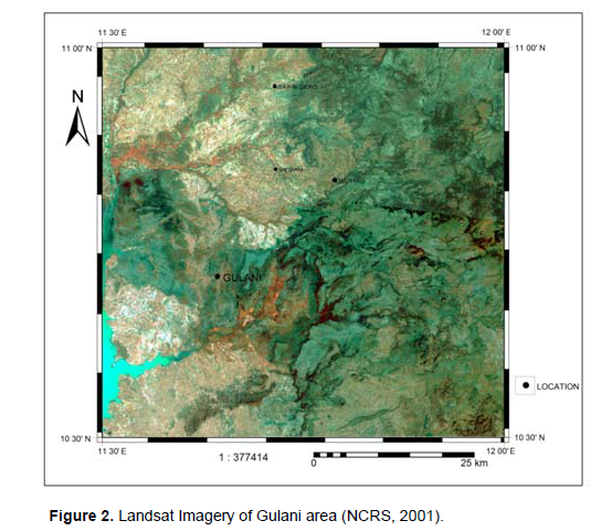
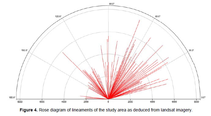
Landsat imagery of the study area was obtained from the National Centre for Remote Sensing (N C R S), Jos. The imagery was processed by digitizing it to produce lineament map using Integrated Land and Water Information System (ILWIS). Then, a rose diagram was produced from the lineament map. This was done by applying ILWIS environment using measure distance tool where angle and length values were displayed in a table. The table is divided into two representing values of 0 to 180° and the distance (length) values along the lineaments at different directions.
Four base maps comprising of 1:50,000 topographic maps representing Gulani sheet 132, NE, SE, NW and SW were used for the mapping exercise. A total area of 2093 km2 was covered using traverse mapping employing the use of compass and global positioning system (GPS) for detail and accurate mapping exercise. Eighty-nine (89) representative rock samples from the various rock units of the study area were selected out of hundreds samples for petrographic study. Standard thin sections of these rocks and polished block sections of Cu mineralized granites were prepared at the laboratories of the Departments of Geology, University of Maiduguri and Ahmadu Bello University Zaria, Nigeria. The petrographic study of the slides and polished sections using polarizing microscopes was carried out at the Laboratories of the Departments of Geology, University of Maiduguri and Kano State University of Science and Technology (KUST) Wudil. The geological map of the area produced was digitized.
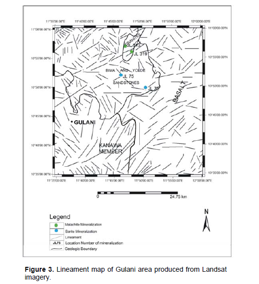
Landsat imagery (Figure 2) was used to produce a lineament map (Figure 3) and rose diagram (Figure 4) of the study area. The major structural trends obtained from these figures are: The NE – SW trend having orientations between 25° to 70° (37.8% dominance); The NW – SE trend having orientations between 112° to 151° (31.9% dominance); The E – W trend having orientations between 70° to 98° (23.5% dominance) and The NNE – SSW trend having orientations between 14° to 22° (6.7% dominance).
The longest lineament trending 68° extends for a distance of 7,579 m (Figure 3). The Gaidam and Wuyaku baryte veins and Garin Gero copper mineralization area 2 plot on or very close to the deduced lineaments (Figure 3). The strikes of the veins measured in the field are: Gaidam baryte mineraralization (GBM) – 014°, Wuyaku baryte mineralization (WBM) – 340°, Garin Gero copper mineralization area 1 (GCM1) – 011° and Garin Gero copper mineralization area 2 (GCM2) – 029°. While those of GBM and GCM1&2 trend NNE-SSW, thus falling within the fourth group of the structural trends given above, the WBM trends NNW-SSE. Unless where expressions of the structures are very prominent such as ridges and depressions that are exploited by river channels it is difficult to locate such structures in plain areas such as those of baryte as indicated by the Gaidam and Wuyaku occurrences. These two baryte occurrences were discovered as a result of erosional activities.
Geology and petrography
Geological mapping of the study area reveals the presence of the Basement Complex rocks, some Cretaceous sedimentary formations and the Tertiary/Quaternary basaltic rocks of the Biu Plateau (Figure 5). The Basement Complex rocks identified are members of the Older Granite series which occur as inliers surrounded by the Cretaceous sediments and the Tertiary basalts, are of restricted occurrences in the study area. The Cretaceous rocks underlie the western part while the basaltic flows of the Biu Plateau are restricted to the eastern part of the study area. Field description and petrographic study of these rocks are given below.
Basement complex rocks
The Basement complex rocks of the study area, which are the oldest, occur as inliers occupying about 5% of the study area and are restricted to the extreme north central and the southeastern corner of the area (Figure 5). The rocks have been identified as diorite, fine-medium grained granite, and medium grained granite .
Diorite: The rock is located 5 km east of Garin Gero in the extreme northern part of the study area (Figure 5). The rock is massive and medium grained in texture. It is mesocratic and occurs as large boulders of low to intermediate lying hills. Carter et al. (1963) reported this occurrence as the only largest body in the northeastern region where diorite form hills. They occur in most cases as flat lying scattered boulders. Calcite veins ranging from 4 mm to 4 cm wide have been observed. The rock is composed of essentially feldspars and
amphiboles with subordinate quartz.
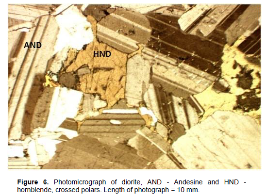
Microscopic observation indicates that the rock is composed of essentially plagioclase feldspar (An35, that is, andesine) with hornblende and accessory quartz and iron oxide (Figure 6). The andesine forms euhedral crystals and are colourless with low relief. Twining is according to albite law with few of the crystals showing combined carslbad and albite twining. These feldspars are highly seriticized. Hornblende occurs as anhedral crystals that are green with pleochroism from pale green to green. Cleavages are in two directions at angles of 56° and 124° while the relief is moderate. The extinction angle is 25°. Only few subhedral quartz crystals occur in the rock. Quartz together with iron oxides forms the accessory minerals of this rock.
Fine-medium grained granite: The rock is located 3.9 km NE of Birnin Gadam in the extreme northern part of the study area (Figure 5). It is fine/medium grained and pinkish in colour consisting of dominantly alkali feldspars, quartz and biotite. It occurs as boulders and low-lying hills. The GCM1 is located within this rock.
Thin section study (Figure 7) indicates that the rock consists of quartz, microcline, orthoclase, plagioclase, biotite and iron oxide. Quartz occurs as anhedral crystals and gives grey interference colour with complete extinction. Microcline shows cross-hatched twinning while orthoclase exhibits carlsbad twinning, both minerals occur in tabular form. Plagioclase feldspar is present but much less in quantity compared to microcline or orthoclase. Biotite, which occurs as flaky brown crystals, constitutes a very small amount of the rock composition. Iron oxide constitutes the accessory minerals of this rock.
Medium grained granite: This rock is located around Danaski and Charengi areas in the southeastern corner of the mapped area as well as at 2.5 km east of Panana in the northern part of the study area (Figure 5). The GCM2 is hosted by this rock at a distance of 4.64 km NE of Panana. It is medium grained and leucocratic in colour (pinkish to light coloured) often it forms hills but also occurs in form of scattered boulders.
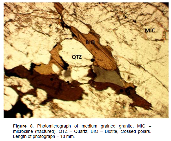
In thin section, the rock is composed of microcline, quartz, plagioclase feldspars, biotite, and opaques with zircon as accessory mineral. The rock shows several fractures in different directions which are mainly manifested by the larger crystals of feldspars and quartz (Figure 8).
Microcline is much more than quartz ranging from 55 to 65% by volume. Microclines, which are fractured, occur as tabular crystals some of which contained inclusions of quartz and myrmekitic structures. Sericitization in feldspars is common in most samples but in varying degrees. Quartz varies from 25 to 30% by volume in different samples. Two generations of quartz were observed; the earlier one represented by the larger subhedral crystals are highly fractured and show undulose extinction which may be as a result of deformation. The second generation made up of smaller crystals are anhedral, not affected by fracturing and show complete extinction (not undulose). Plagioclase feldspars are very much less than microcline but could be up to 7% by composition in some samples and are also sericitized. Biotite on the other hand varies from 3 to 6% and usually occurs as flakes or tabular form. They are brown and pleochroic from pale brown to dark brown. Some crystals show bent twin lamellae, which indicate deformation. Zircon inclusions are observed in some biotite crystals. Opaque minerals occur in this rock forming accessory amounts to about 2% of the rock composition.
The Cretaceous sediments
The Cretaceous sediments constitute about 58% of the total area coverage and occupy the western part of the study area (Figure 5). Formations encountered include Bima Sandstone, Yolde Formation and Pindiga Formation (represented by two members, that is, the Kanawa and the Gulani Members).
Bima sandstone
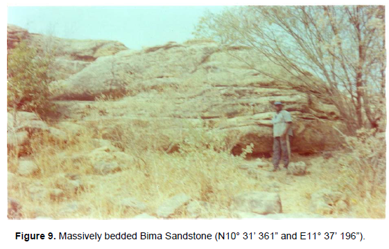
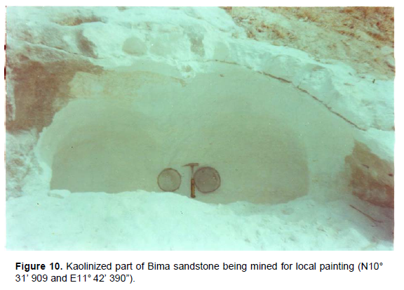
The Bima sandstone underlies the areas around Bantini and Birnin Gadam; Titeba to Yalori; east of Balbaya; Waram and the Padam hill area south of Wula Wula. This is the oldest sedimentary Formation directly overlying nonconformably the Basement Complex rocks. It is massive and thickly bedded (Figure 9) and consists of mainly medium grained cream, whitish, grey and buff feldspathic sandstone. Occasional fine and coarse grained sandstone are encountered. The rocks are generally poorly sorted, where weathered, they appear reddish or brownish. Some hill outcrops such as the Padam hill (N10° 45' 357” and E11° 57' 249”) and others including those at locations N10° 53’ 667” and E11° 43’ 118”; N10° 53’ 833” and E11° 43’ 211”; and N10° 55’ 084” and E11° 45’ 860” consist of highly indurated Bima sandstone. The Bima sandstone in several locations contained large embedded pebbles of quartz and feldspars. The Bima sandstone is composed of quartz and feldspars but in some instances, some of the feldspars are kaolinized (Figure 10). Cross beddings and joints were recorded at some locations. The WBM is hosted by this formation at location (N10° 50' 998” and E11° 50' 711”).
In thin section the Bima sandstone consists of quartz, microcline, plagioclase, biotite and opaques. Quartz occurs as white subangular to subrounded grains and shows complete extinction. However, few relatively large crystals are fractured while some few show undulose extinction. Microcline occurs as both large and small tabular angular grains with the characteristic cross–hatched twinning. The larger grains are also fractured. Few plagioclase feldspar grains occur in this rock. The average extinction angle is 7°, which corresponds to An15 implying oligoclase. Biotite occurs as flaky, somehow rounded, and pale brown or brown in colour but do not show the characteristic pleochroism which could be as the result of alteration. The above mineralogical composition reflects the features exhibited by the local granites from which the Bima sandstones were derived.
Yolde formation
The Yolde Formation underlies the northwestern part of the study area and it hosts the GBM (Figure 5). It is generally poorly exposed and gives rise to a subdued topography often with sparse vegetation cover. However there are some areas represented by flat topped medium lying hills and exposures. The Formation comprises of thin alternating sequences of mostly fine grained sandstones, siltstones, mudstones and in few instances medium grained sandstones and shale which is the least repeated sequence (Figure 11).
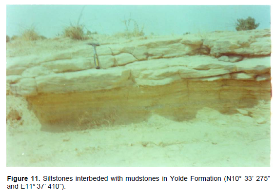
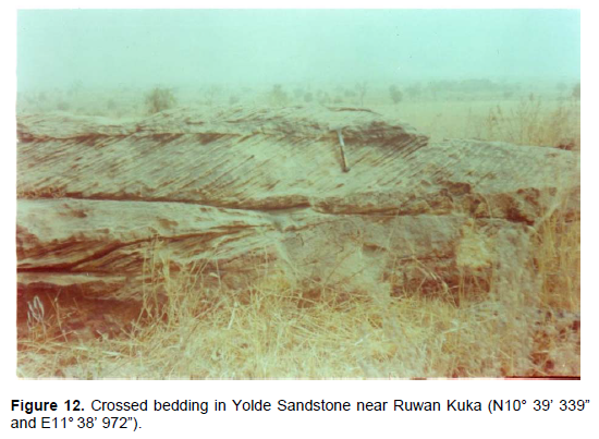
The sequences occur mainly as soft but consolidated rocks, however, indurated fine grained sandstones and siltstones have been encountered in some locations. The colour of these sequences varies from whitish, grey, light grey through light brown, brown to purplish colour. Light and brown colours are indications of alteration due to weathering process and some of the hills have lateritic cappings. The mineral composition is made up of quartz and feldspars with some heavy black minerals in some few cases. Structurally, the rock sequences of this formation comprise of thin beds mostly of less than 1 m thick and less frequently few meters (rarely more than 5 m) thick. Cross beddings are quite common in the sandstones (Figure 12) while laminations and desiccation cracks are exhibited by the siltstones. Joints and synclinal structures are also common especially in the fine grained sandstones. Microscopic study indicates that the rock consists of subangular to subrounded grains of quartz, microcline and accessory opaque minerals. Some of the larger quartz grains are fractured. Plagioclase feldspars are rarely seen.
Pindiga Formation
The Pindiga Formation in the study area is represented by two members namely, the Kanawa Member and the Gulani Member.The Kanawa Member occurs in the west central edge of the study area and the southwestern part around Gaza and Balbaya areas and in the northwestern part east of Nainawa (Figure 5). The member is marked by a generally featureless topography in cultivated areas and in uncultivated areas the vegetation cover is largely that of thorny bushes. The lithology comprises of mainly shales which in places may contain some limestone beds. In some instances the limestone forms distinctive continues outcrops that are interbedded with the shales. The shales appear grey or dark coloured and weather to the distinctive black cotton soil which is heavily cultivated in most areas. The limestone bodies on the other hand are mostly grey but light brownish colours are encountered. They are either fossiliferous or crystalline, the former contain principally bivalves and ammonites. The main structural feature of this formation is the desiccation cracks associated with the shales.
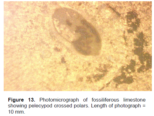
A typical section of this formation is exposed by a river at location N10° 46' 780” and E11° 35' 664” where the sequence comprises (from lower part to the surface) of the following: brown shale (base not seen) - 22 cm; grey limestone - 19 cm; grey brownish shale - 73 cm; black over-burdden with limestone fragments - 114 cm. The crystalline limestone is composed of calcite, quartz, dolomite and subordinate plagioclase and microcline, while the fossiliferous type, in addition to calcite and dolomite, contains fossils identified as pelecypods (Figure 13). The calcite grains are in most cases large showing perfect rhombohedral cleavages in two directions. The relief varies in different directions but is generally moderate. The interference colour is pearl grey of higher order. Extinction is parallel to cleavage direction while polysynthetic twinning is common.
The Gulani Member occurs around Gulani through Garin Tuwo to Jana areas of the study area (Figure 5). It mainly consists of medium grained sandstone. Other sediments include fine grained sandstones, siltstones, mudstones and ferruginous sandstones. This member is mostly represented by hills some of which are made up of entirely medium grained sandstone which in few cases are massively bedded. Other hills comprises of two or more of the above lithologies. The top of the hills are mostly lateritized. Few sandstones outcrops have coarse grained texture and some are gritty. The colour of this member varies from light grey, dark grey, cream, whitish to light brown, brown and reddish brown. The brown, light brown and reddish brown colours are indications of degree of weathering. The sandstone is in places calcareous.
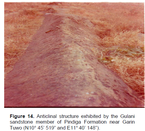
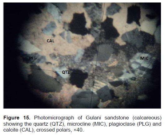
The sandstones and the siltstones are laminated. In few places the sandstone appears jointed. Anticlinal structures have been located at two outcrop locations N10° 45' 519” and E11° 40' 148”, and N10° 46' 979” and E11° 41' 232” (Figure 14). The prominent Anticlinal structure shown in Figure 14 strikes 036° and dips 61° NW and 40° SW. The mineral composition is largely quartz with subordinate feldspars.Microscopic investigation indicates that the sandstone of the Gulani member is composed of quartz, calcite, and microcline with very few opaques and plagioclase (Figure 15). The grains are subangular through subrounded to round. Quartz shows complete extinction although some few larger grains exhibit andulose extinction. The calcite crystals are irregular in form and appear to have filled–up the pore spaces between quartz and feldspar. Some of the crystals show the characteristic rhombohedral cleavages with twinning commonly observed and anomalous interference colour. Microcline shows the characteristic cross-hatched twinning. Traces of biotite also occur.
Basalts
Basalts overlie the eastern part of the study area (Figure 5) forming escarpments, hills or ridges, generally represented by large boulders. Other areas of coverage occur as slightly elevated or flat landscapes occupied by scattered or densely packed large or small boulders and fragments of the basalts. They appear dark, grey, or dark grey in colour. The rocks are largely massive although the upper parts of the lava flows appear vesiculated. The vesicles are commonly occupied by calcite but less frequently zeolites. Olivine nodules are commonly associated with these rocks.
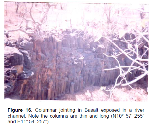
At least two lava flows are exposed by a river at location N10° 57' 350” and E11° 53' 199” where the top lava flow is seen to hang over on a weathered material (40 cm thick) and cemented rubble of basaltic fragments of 150 cm both materials in turn overlying the top of the lower lava flow. At this location and location N10° 57' 255” and E11° 54' 257” impressive columnar jointing are displayed (Figure 16). Petrographic study indicates that the rock is composed of plagioclase laths, olivine, augite and opaques.
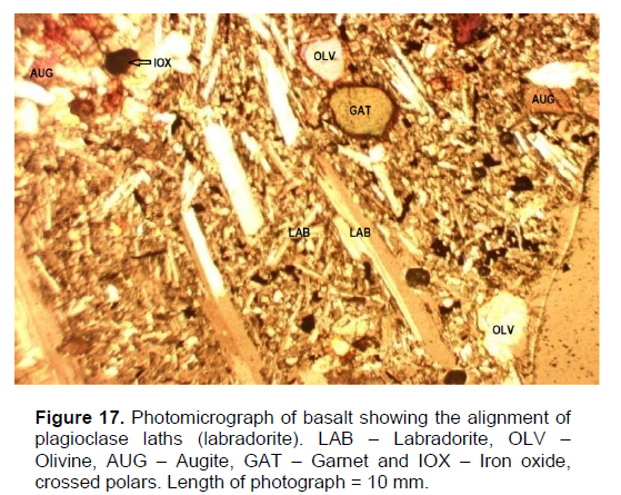
Generally, olivine occurs as phenocrysts as well as anhedral crystals within the groundmass of plagioclase laths, augite and opaques. Plagioclase occurs as colourless laths with low relief and cleavages in two directions at right angles. Twinning is according to albite law and the average extinction angle is 29° corresponding to An52 indicating labradorite. Interference colour is grey of the first order. The laths in some thin sections show alignment in certain direction, which indicate flow direction of the lava (Figure 17). Modal compositions of this mineral vary widely from 25 to 50%.
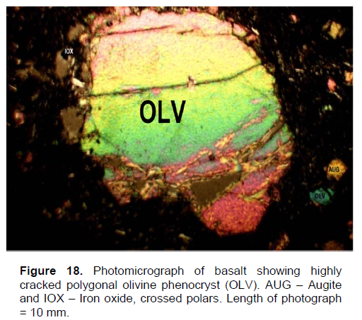
Olivine occurs as colourless crystals with moderate relief. They occur in two forms as phenocrysts and anhedral small crystals in the groundmass. The phenocrysts are in euhedral form and commonly appear in polygonal or prismatic outlines (Figure 18) with the characteristic cracks associated with olivines. Some of these phenocrysts show cleavages and extinction is parallel to the cleavages where they exist or parallel to the crystal outline. Interference colour is either yellow or blue.
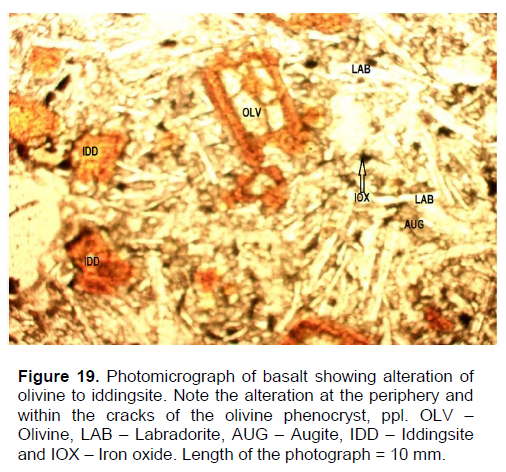
Yellowish interference colour which is more commonly observed is an indication that the crystals are of forsterite type (MacKenzie and Guilford, 1980). The blueish interference colour, which is much less common, is a reflection that the crystals are fayalitic (MacKenzie and Guilford, 1980). On the other hand, the anhedral crystals of the groundmass are not fractured and do not show cleavage traces but they exhibit both yellowish and blueish interference colours. Some of the olivines especially the phenocrysts show reddish brown peripheries or the cracks appear brownish which are indications that the crystals have started altering to iddingsite. Partial or complete replacement of olivine to iddingsite with the pseudomorph of the iddingsite after the olivine is commonly observed in some slides of these rocks (Figure 19). Some olivine phenocrysts contained some inclusions of opaque minerals. Modal composition of olivine varies from 15 to 40%.
Augite occurs as tabular, prismatic or four sided small crystals in the groundmass. They also occur as fine grained anhedral crystals. The colour varies from colourless, pale brown to pale purplish with slight or non-pleochroism. Relief is moderate to high with cleavages in two directions at right angles to each other. Interference colour is purplish or dark brown and the extinction angle varies from 17 to 36°. Augite in the rock varies in composition from 5 to 25%.
Implication of fractures and pore spaces to Baryte and Copper mineralizations
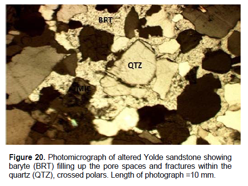
Geological mapping of the study area revealed the presence of epigenetic baryte and copper mineralizations associated with the rocks of the area (Figure 5). Baryte veins GBM and WBM of Gaidam and Wuyaku areas are associated respectively with the Yolde and Bima sandstones of the Cretaceous formations. On the other hand the GCM1 and GCM2 of the Garin Gero Copper (malachite) mineralization areas are restricted to Pan-African granites. The baryte veins vary in length from 17.2 to 75 m with width ranging from 3.4 m to 5 m. The baryte occurs as white massive material having hardness of 3 on Mohs scale. Their densities vary from 3.5 to 5.58 g/cm3. The petrography of the unaltered sandstones has been described earlier. However, the hydrothermally altered sandstones of the GBM and WBM show similar characteristics. They are composed of quartz, baryte, microcline and plagioclase feldspars ± clay minerals. The large quartz and microcline crystals are fractured. The baryte occurs in irregular forms filling up the pore spaces between the quartz and feldspars and within the fractures of these minerals (Figure 20). This implies the possible permeation of the baryte-bearing hydrothermal solutions into the rocks reflecting epigenetic mineralization.
The geology of the GCM1 and GCM2 comprises of fine/medium grained granites, medium grained granite and Bima sandstone. The GCM1 is located within the fine/medium grained granite while the GCM2 is hosted by the medium grained granite. Both mineralizations occur within highly fractured zones and are located very close to the granite/Bima sandstone contacts. The extent of the zones range from 15 m to 23 m and 4.8 m to 5 m wide. The mineralizations are composed of malachite and minor chalcopyrite relicts in veins/veinlets (Figure 21). Reflected light microscopy of the Cu mineralized granites of GCM1 and GCM2 show chalcopyrite as the original primary sulphide mineral which altered to malachite and its associated limonite. The malachite and limonite occur as pseudomorphs after the chalcopyrites (El-Nafaty, 2014).
The interpretation of the structural trends deduced from the Landsat imagery of the study area revealed four dominant orientations trending NE – SW, NW – SE, E – W and NNE – SSW directions (Figures 3 and 4). These trends are similar to those shown in the structural map of Nigeria (
GSN, 1974) . Field observation indicates that the two identified copper mineralizations (JL 313 and JL 319) and one barite vein (JL75) trend NNE – SSW while the other barite vein (JL 73) is oriented NNW – SSE direction (Figure 3).
The geological map of the study area has been produced and the lithologies encountered include Basement Complex rocks, Cretaceous sedimentary formations and Tertiary/Quaternary basalts of Biu Plateau. The Basement Complex rocks occur as inliers consisting of diorites and granites. The diorites are largely composed of andesine plus hornblende and accessory quartz and iron oxide. The granites on the other hand consist of essentially quartz and microcline and some orthoclase, biotite and iron oxide. Large quartz and microcline crystals are fractured and this has implication to the emplacement of copper mineralization associated with the granites.
The Cretaceous sediments include Bima sandstone, Yolde Formation and Pindiga Formation represented by Kanawa and Gulani members. Baryte veins are associated with the Bima and Yolde sandstones whose large grains of quartz and microcline are also fractured similar to those of the granites mentioned above. The feldspathic Bima sandstone is also partially kaolinized, the material been used for painting of mud houses by the local inhabitants. The basalts are commonly massive while others are vessiculated. Microscopic study of the basalts shows that they are composed of plagioclase laths, olivine, augite, calcite and opaques. Some of the olivine crystals show partial to complete replacement to iddingsite (Figure 19) (Carter et al., 1963; Islam, 1986) a situation described as the effect of dueteric or hydrothermal alteration and not by weathering process (Kerr, 1977).
The quartz and microcline crystals of both the granites and sandstones which host the copper mineralization and baryte veins respectively are found to be fractured, a situation which enhanced the permeation of the hydrothermal solutions through the host rocks and the subsequent deposition of the baryte and sulphides in pre-existing fractures. The baryte occurs as massive fracture-filling veins (Adubok and Imoekparia, 2008; Daspan and Imagbe, 2010) while in the hydrothermally altered sandstones the baryte tends to fill up the pore spaces between the quartz and feldspars and within the fractures commonly found in these two brittle minerals (Figure 20). In GCM1 and GCM2 in addition to the fractures, the hydrothermal solutions exploited cleavages and twin planes of microcline and the subsequent deposition of the primary sulphide veins/veinlets. The malachite and limonite formed as secondary alteration products of these veins/veinlets containing chalcopyrite as the primary sulphide minerals (El-Nafaty, 2014). The baryte and sulphide mineralization of the study area most likely forms the northern extension of the main mineralization system of Pb-Zn-Cu-F metallogenetic belt of the Benue Trough as reported by several workers including Farrington (1952), Olade (1976), Akande and Abimbola (1987),
Ford (1989) and Wright (1989).
Detail geological mapping and petrographic study of the rocks and to some extent baryte and copper mineralizations are documented thereby upgrading the geological knowledge of the study area. The petrography of the granites and sandstones indicate that the large quartz and microcline crystals in these rocks were fractured. The presence of these fractures influenced the movement of hydrothermal solutions and the deposition of baryte and chalcopyrite/malachite in the identified mineralization areas. Reflected light microscopy of the Cu mineralized granites in GCM1 and GCM2 indicate the presence of chalcopyrite which occurs as relicts in veins/veinlets. The chalcopyrite now almost entirely altered to malachite and its associated limonite.
The author has not declared any conflict of interest.
The author wishes to thank Prof. Ibrahim Garba, the former Vice Chancellor of the Kano State University of Science and Technology, Wudil, for granting special permission to use the laboratory facilities of the newly created Department of Geology of the Institution. Thanks are due to the previous Heads of Departments of Geology, Ahmadu Bello University, Zaria and Kano State University of Science and Technology, Wudil, in persons of Prof. U. A. Danbatta and Dr. A. A. Ibrahim for allowing the use of their laboratory facilities. Dr. Saidu Baba of the Department of Geology, University of Maiduguri, is gratefully acknowledged for going through the draft manuscript and making useful criticisms and suggestions.
REFERENCES
|
Adubok AS, Imoekparia EG (2008). Trace elements distribution and enrichment in soils overlying barytes vein deposits in the Paya district, Middle Benue Trough, Nigeria. Continental J. Earth Sci. 3: 22-27. |
|
|
|
Akande SO, Abimbola AF (1987). Aspects of the genesis of lead-zinc– fluorine – baryte mineralization in the Nigerian Benue Trough. In: Matheis G, Schandelmeier H (eds.) Current research in African earth sciences. Balkema, Rotterdam. pp. 365 – 369. |
|
|
|
Baba S, El-Nafaty JM, Nkereuwem OT (1995). The occurrence of industrial mineral deposits in Yobe State, Nigeria. Res. J. Sci. 1 (1): 34 – 45. |
|
|
|
Baba S, Islam MR, El-Nafaty JM, Amate MK (1991). Exploration and evaluation of industrial minerals and rocks in the northern part of Mandara hills N.E, Nigeria. J. Min. Geol. 27 (2): 11 – 14. |
|
|
|
Carter JD, Barber DFM, Tait EA (1963). The Geology of parts of Adamawa, Bauchi and Bornu provinces in North-eastern Nigeria. Geol. Surv. Nigeria, Bull. No 30. |
|
|
|
Dada SS, Suh CE (2006). Finding economic uranium deposits and the Nigerian energy mix: Implications for national development. In: Abaa SI, Baba S (eds.), Proc. first Petr. Tech. Dev. Fund (PTDF) workshop, University of Maiduguri, pp. 34 – 48. |
|
|
|
Daspan RI, Imagbe LO (2010). Preliminary investigation of the origin and quality of baryte in the Tsareta-Tungan Kudaku area, North Western Nigeria basement complex, Nigeria. Continental J. Earth Sci. 5(1):8 – 13. |
|
|
|
El-Nafaty JM (2014). Geology geochemistry and mineralization of Gulani area, northeastern Nigeria. Unpubl. Ph.D thesis, Dept. of Geol. Univ. of Maiduguri. P. 163. |
|
|
|
El-Nafaty JM, El-Nafaty AA (2000). Occurrences, geochemistry and origin of gypsum deposits in Nafada, Gombe State, Nigeria. Glob. J. Pure Appl. Sci. 6(2):243 –247. |
|
|
Farrington JL (1952). A preliminary description of the Nigerian lead-zinc field. Econ. Geol. 47(6):583-608.
Crossref |
|
|
|
Funtua II, Okujeni CO, Elegba SB, Mustapha AO (1992). Biogeochemical technique applied in uranium exploration. J. Min. Geol. 28(1):159 –161. |
|
|
Funtua II, Onojah A, Jonah SR, Jimba BW, Umar IM (1997). Radon emanation study of uranium ore samples from N.E. Nigeria. Appl. Rad. Isotopes. 48 (6):867 – 869.
Crossref |
|
|
|
Funtua II, Ogunleye PO, Umar IM, Elegba SB (1998). Preliminary studies on the recovery of uranium from Mika, northeastern Nigeria. J. Min. Geol. 34(2):219 – 224. |
|
|
|
Funtua II, Okujeni CD, Elegba SB (1999). Preliminary note on the geology and genetic model of uranium mineralization in Northeastern Nigeria. J. Min. Geol. 35(2):125 – 136. |
|
|
|
Geological Survey of Nigeria (1974). Structural map of Nigeria. |
|
|
|
Guiraud M (1991). Me'canisme de formation du basin cre'tace' sur de'crochements multiples de la Haute-Be'noue' (Nigeria). Bullet Centres Reches Expl.- prod. Elf - Aquitaine 15:11 – 67. |
|
|
|
Idowu JO, Ekweozor CM (1989). Petroleum geochemistry of some Upper Cretaceous shales from Upper Benue Trough and sourthwestern Chad Basin, Nigeria. J. Min. Geol. 25 (1&2): 131-149. |
|
|
|
Islam MR (1986). The petrological study of Biu basalts, Borno State, Nigeria. Annals of Borno, III:215 – 226. |
|
|
|
Islam MR, Baba S (1990). The mineral potential of the northern part of Mandara hills, Nigeria. Berg-und huttenmannische monatshefe (BHM) 135(4):95 –98. |
|
|
|
Kerr PF (1977). Optical mineralogy. Fourth ed. McGraw Hill, Inc, New York, P. 492. |
|
|
|
Mackenzie WS, Guilford C (1980). Atlas of rock-forming minerals in thin section. Logman Group Limited, London, P. 98. |
|
|
Maurin JC, Lancelot JL (1990). Structural setting and U-Pb dating of uranium mineralization from the northestern part of Nigeria (Upper Benue Region). J. Afr. Earth Sci. 10:421-433.
Crossref |
|
|
|
National Centre for Remote Sensing (NCRS), (2001). Landsat Imagery. |
|
|
Obaje NG, Wehner H, Hamza H, Scheeder G (2004). New geochemical data from the Nigerian sector of the Chad Basin. Implication on haydrocarbon prospectivity. J. Afr. Earth Sci. 38: 477-487.
Crossref |
|
|
|
Ogunleye PO, Okujeni CO (1993). The geology and geochemistry of Zona Uranium occurrence, Upper Benue Trough; N. E. Nigeria. J. Min. Geol. 29(2):175 –181. |
|
|
|
Okujeni CD, Funtua II (1994). Geochemical and gamma spectrometric analysis of ores and host rocks of the kanawa uranium occurrence in NE Nigeria. J. Radioanal, Nuc. Chem. Articles 178(2):375–385. |
|
|
|
Olade MA (1976). On the genesis of lead – zinc deposits in Nigeria's Benue Rift (aulacogen) – a re-interpretation. J. Min. Geol. 13(2):20 –27. |
|
|
Oshin IO, Rahman MA (1986). Uranium favourability study in Nigeria. J. Afr. Earth Sci. 5(2):167–175.
Crossref |
|
|
|
Popoff M, Wiedmann J, de KLasz I (1986). The Upper Cretaceous Gongila and Pindiga Formations, northern Nigeria: subdivisions, age, stratigraphic correlations and paleogeographic implications. Eclogue geologicae helvetiae, 79:343 –363. |
|
|
|
Turner DC (1978). Volcanoes of the Biu plateau basalts, northeastern Nigeria. J. Min, Geol. 15 (2):49 – 63. |
|
|
|
Zaborski P, Ugodulunwa F, Idornigie A, Nnabo P, Ibe K (1997). Stratigraphy and structure of the Cretaceous Gongola Basin, Nigeria. Bull. Centres Recherhes Expl.- Prod. Elf-Aquitaine 21:154 – 184. |