Full Length Research Paper

ABSTRACT
The Las Encadenadas basin can be defined as an endorheic fluviolacustrine system. The aim of this study is to identify hydrographic sectors and subbasins within the Encadenada’s drainage basin and analyze the former’s morphometric properties including hypsometry. The morphometric analysis allowed for quantification of variables and indices for example area, perimeter, total length of streams, etc. Hypsometric curves were also plotted for each subbasin and finally, principal components analysis was used to sort basins based on results from individually calculated parameters and indices. This study’s aim was to define for the first time the various drainage subbasins that comprise the Encadenadas del Oeste’s basin. The characterization of these units shows that the basin is morphologically diverse due to the dynamic fluvial activity that prevails within its limits. One of the above mentioned morphological units are the alluvial cones which form at the mouths of the mainstreams and delineate the bases of the different subbasins. The drainage network exhibits overall a low level of ramification and hierarchy which is likely due to the sedimentary nature and high permeability of the sub-surface soil.
Keywords: Basin, morphometric, drainage subbasins, hypsometry.
INTRODUCTION
Drainage basins and morphometric analysis have been the topic of numerous studies worldwide after interest in the subject picked up in the mid-twentieth century in the United States (Horton, 1945, Miller, 1953; Strahler, 1952, Schumm, 1956). These studies set groundwork for current research such as van der Linden and Woo’s (2002) which modeled runoff and hypsometric curves in the Liard basin, Canada. Luo and Howard (2005) used a “circularity” function to quantify drainage basin morphology, infer erosion processes, characterize geomorphology and link them to climatic conditions. It is also used to derive drainage basin elongation and hypsometric curves at various elevation levels. The authors found that basins which are morphologically similar to their terrestrial counterparts are clustered around mainstreams at lower elevations, while cliffed basins whose origin likely is groundwater sapping develop around tributaries at higher elevations. This classification fits dry climate conditionspunctuated by wet periods.
Silva et al. (2006) analyzed and compared the morphometric attributes of some drainage basins located in Brazil. Their characterization is based on various parameters and indices such as area, perimeter, mainstream length, compactness index, drainage density, etc. They linked these parameters to the geological characteristics of the area and demonstrated that morphology is controlled by the main regional rock type. Basins overlying sedimentary bedrock and basins with a dissected relief exhibit lower current density and compactness index values than those with a smooth topography.
In Argentina, Doffo and Bonorino (2005) produced a morphometric characterization of Las Lajas drainage basin in Cordoba using statistical analysis to look specifically at the control of structure and lithology over drainage network patterns. Morphometric data were analyzed using techniques like correlation, dispersion, factorial analysis, etc. and ultimately revealed no lithological control over the drainage network. Subbasin analysis indicated they belonged to two different groups, neither of which was found to be controlled by structure or substrate lithology.
The Claromecó stream catchment was studied by Carbone and Piccolo (2002) whom described the drainage network hierarchy and characterized the basin based on edaphic and geomorphological parameters. Munguía and Campo de Ferreras (2003) studied geomorphological features of the Pescado Castigado creek basin associated with runoff. They also carried out a description of slope morphology, hypsometric curves and topographic profiles.
One study which stands out is Uriarte and Orioli’s (1998) geo-environmental map of Guaminí county (Province of Buenos Aires). This study characterizes the potential and behaviour of water resources through pluviometric and hydrological budget analysis and also does a detailed study of groundwater resources. Navarro and González (1998) used a mathematical model running least squares and regression analysis to estimate the soil storage capacity for excess water based on a geomor-phological model. They also evaluated the area’s geomorphological characteristics and quantified areas in-between contour lines. Lastly, calibration of their mathematical model confirmed realistic peakflow estimates.
The Province of Buenos Aires mostly comprises planation surfaces of low morphogenic energy. These overlie unconsolidated quaternary sediments that were reworked and redistributed by eolian - and to a lesser degree - hydrological processes. The apparent monotony of these plains is interrupted by mountain ranges such as the Tandil and Ventana (Figure 1). The latter are charaterized by rugged relief in the highest sectors where rock outcrops are overlaid by thin loess layers. Their piedmont area is smooth and dissected by a well-defined dendritic drainage network formed by the sloping terrain (De Francesco, 1971).

The regional morphostructure underlying the basin is divided into two units: the southward Norventánica prairie (Fidalgo et al., 1975) which includes the Positivo Bonaerense (Ventania mountain range) (Yrigoyen, 1975) and the northward Western sandy prairie (Figure 1). The former comprises sub-parallel ridges up to 180 km in length and 50 km in width ranging in age from the pre-Cenozoic to the late Holocene (Zarate et al., 2005). The Ventania is sigmoid in shape and likely arised from block faulting (Martinez, 2001). The Puán and Pigüé mountains are located in its northeastern sector and border an arc-shaped valley flanking the central section of the range, across which lie the western Curamalal and eastern Bravard mountains (Martinez, 2001).
The Western sandy prairie consists exclusively of dunes arranged parallelly to the Encadenadas lakes. The area’s highest elevation point occurs 130 meters above mean sea level (amsl). The concave dune slacks are filled by intermittent lakes. These landforms extend towards the north of the province, their crescent shapes clearly indicating an eolian origin. Their formation has been cyclic, alternating between periods of pedogenesis and erosion (Uriarte and Orioli, 1998).
The region’s oldest geological units are 500 to 200 million years old (Harrington, 1947). It is characterized by linear structures of younger age which formed as a result of tectonic faulting that caused the uplifting of the Positivo Bonaerense (also known as Ventania system) and the downlifting of other areas such as those extending north of the Encadenadas depression (Uriarte and Orioli, 1998). These events were determinant in the pattern and distribution of the latter’s drainage basins.
Surface runoff is controlled by a five million year old deposit of eolian sediments covering the area whose top layer is as much as 100 m thick (Uriarte and Orioli, 1998). The layers at the base of this deposit were named Pampean (Pampeanos) by Ameghino (1880) while the top ones, Postpampean (Postpampeano) (Uriarte and Orioli, 1998). Knowledge of these sediments is important since they exert control over the present landscape and materials over which soils form.
The area in which the lakes are located (Epecúen, Venado, Cochicó, Del Monte y Alsina), between the Norventánica plain and the Western sandy plain is refered to as a collector belt (Uriarte and Orioli, 1998). The development of this belt is a topic of scientific debate which has not been solved yet although it is believed that this break in topography formed from a regional fracture, a fault trending SW-NE which would exert structural control over the lakes’ striking alignment. A dynamic fluvio-morphological regime is also evidenced by the occurence of alluvial cones in-between the lakes.
The depression formed by the Encadenadas del Oeste drainage basin gives way southward to mountains where elevations reach a maximum of 1015 meters amsl. They decrease to a minimum of 85 m amsl northward in Epecuén lake, with most of the area lying between 150 and 300 m amsl.
The basin can be defined as an endorheic fluvio-lacustrine system. The southern part of its catchment area is delineated by mountains whose streams supply Epecuén Lake. From West to East, the lakes and their mainstreams are Epecuén lake, Pigüé and Pull streams; Venado lake and Venado stream; Monte lake, Guaminí and Malleo Leufú streams; Alsina lake and Cura Malal, Pescado and Corto streams.
The physical setting of this drainage basin is a low sloping plain with steepness increasing in the mountain area and with surface runoff trending South-North. The most peculiar characteristic of this basin is its climate which alternates between very humid periods and intense droughts that occur in 8 to 12 year cycles.
Consequently and because it is an endorheic basin, characterization of its morphometry is of great importance for land-use planning. The aim of this study is to identify hydrographic sectors and subbasins within the Encadenada’s drainage basin and analyze the former’s morphometric properties including hypsometry. An attempt will also be made to analyze behaviour of the drainage network in light of basin dynamics and identify those factors that control fluvial morphology. Moreover, since few regional studies have focused on this topic, the present study has a greater significance.
METHODS
Environmental characterization of a drainage basin first involves looking at its morphometric properties. These have a great impact on aquatic ecology given that many indicators, physico-chemical properties, sedimentation, etc. are controled by basin shape. Morphometric studies typically seek parameters which on one hand properly describe a geomorphological environment and on the other, allow for their statistical analysis thereby limiting the subjectivity of their conclusions (Doffo and Bonorino, 2005). This study relied on four different methods: cartographic analysis, field work, use of morphometric indices and statistical techniques.
The first step involved quantifying the relief. Contour lines with a 2.5 m interval were digitized from the Military Geographic Institute’s 1:50 000 and 1:100 000-scale topographic maps. They were then georeferenced and mosaiced into one set covering the entire basin. The drainage network was also digitized from topographic maps and updated with Landsat 5 TM satellite imagery provided by the Argentine National Commission for Spatial Activities (CONAE).
Given that the area is highly impacted by anthropogenic activities, a systemic analysis (Capitanelli, 1998) was performed to quantify regional space and embedded cultural elements such as channels, railways, sluice-gates, etc. Field trips were carried out to determine stream junctions and ground truth elevations as well as geographic coordinates with a GPS (global positioning system). Data thereby acquired were then used to delineate each subbasin by choosing points of highest elevation on either sides of the mainstream and its outlet. ArcGIS 9 and relevant extensions were used for this task and enabled instantaneous acquisition of parameters related to topography, basin length, etc. Once delineation of the subbasins was completed, morphometric analysis of their properties was carried out. The latter is of great importance if only to estimate the delay required for water to flow from a basin’s edge to its outlet. The morphometric analysis allowed for quantification of variables and indices originally developped by Horton (1945), Strahler (1952) and Schumm (1956).
The drainage area (A) and perimeter (P) are two parameters which are useful for determining preliminary territorial dimensions of a drainage basin. These parameters are also useful for establishing general characteristics of the latter such as the climate zone it is part of, topography of the territory it encompasses, urbain and rural areas and others which can be infered from a global cartographical interpretation.
In order to determine linear properties of the basin, a number of parameters were quantified including basin length (L), total length of streams (Lt), mainstream length (Lc), number of perennial and intermittent tributaries (NS) and number of streams of order 1 and 2 (N1 and N2). Area, fluvial streams, slopes, etc. were also analyzed in a GIS. Shape was determined using a variety of indices presented in Table 1.

With regards to basin shape, it is assumed that as values trend away from zero, peakflow levels and erosive action increase. If values trend towards zero, this potential is reversed. Basin shape was established on the basis of a morphological classification elaborated by López in 1988 (Fuentes Junco, 2004) where values ranging between 1.00 and 1.25 are deemed round; 1.25 to 1.50, oval; and 1.50 to 1.75, oblong. Hierarchical categorization was based on Strahler’s version (1952) of Horton’s system (1945) which Gardiner (1974) qualified as adequate for objective and hierarchical applications. Analysis of surfaces and visualisation of data in three dimensions was carried out using a DEM (digital elevation model) derived from contour lines data and plotted as a TIN (triangular interpolation network). A TIN is essentially a vectorial data structure that stores and displays a surface model. It partitions a topographic surface into a group of contiguous and separate triangles. Sampled points are converted into triangular vertices or nodes whose elevation values are interpolated into a continuous surface. Triangles are calculated based on the Delaunay triangulation model which states that a circle drawn around the node of any of these will contain that point and no other ones (Sione et al., 2004). Hypsometric curves were also plotted for each subbasin and finally, principal components analysis (PCA) was used to sort basins based on results from individually calculated parameters and indices.
RESULTS AND DISCUSSION
The topographic analysis of the Encadenadas del Oeste basin resulted in the identification of each subbasin it is comprised of. This typology, the first for the area, will be a useful tool for future regional studies. The basins were classified as follows:
a. Main subbasins: Include those that flank the mountain range (Figure 2) and are bisected by mainstreams:

1. Corto stream subbasin (CAC)
2. Pescado stream subbasin (CP)
3. Cura Matal stream subbasin (CACM)
4. Guaminí stream subbasin (CAG)
5. Pigüé stream subbasin (CAP)
b. Intermediate subbasins: Located in the central part of the Encadenadas basin which is characterized by prairie (Fig. 2). They fill the areas in-between the larger subbasins and are catchments for smaller typically intermittent streams whose sources are found in gullies rather than the mountains:
1. Pull stream subbasin
2. Venado stream subbasin (CAV)
3. Malleo Leufú subbasin (CAML)
4. Cochicó stream subbasin (CaC)
c. Alluvial cones: Sedimentary formations of triangular shape whose wide bases are contiguous to the lakes and apexes intersect with the subbasins. Alluvial fans form at the outlet of streams due to the decreasing slope, slower currents and widening valleys where material from higher grounds typically tend to acrete (Strahler, 1952). They are flat and are formed by alluvial deposits. These units lie in-between the lakes and subbasins and are named after the latter:
a . Epecuén Lake alluvial cone
b .Epecuén - Venado alluvial cone
c. Venado Del Monte alluvial cone
d. Del Monte - Cochicó alluvial cone
e. Cochicó - Alsina alluvial cone
f. Cura Malal - Pescado alluvial cone
g. Pescado - Corto alluvial cone
Sand dune subbasin: Located north of the lakes and populated by sand-dunes. No stream drains into it. Notable morphological units in the area include sand dunes, sand veneers, dune slacks and blow outs. Four litho-stratigraphic units and paleosoils have been described from the area (Dillon et al., 1985) as have compact alluvia at various depths of the Epecuén formation (Dillon et al., 1985). Fine to silty alluvial sands from the Hereford Formation are thought to date back to the Upper Pleistocene. These are overlain by the clayey to sandy and clayey to silty alluvial deposits of the Carlos Tejedor formation. These may be related to the extensive and typical fluvial deposits known as lujanenses (from Lujan) that are characteristic of the Late Pleistocene in the Province of Buenos Aires.
The topmost layer of this sequence is made of an eolian deposit of fine sands known as Las Lilas formation (Holocene) (Isla et al., 2003). A drainage basin’s size is of great importance when it comes to its hydrological behaviour. Typically, the larger it is in area,the morerainwater it collects and the greater is its peakflow level. Nonetheless, there is a delay between rainstorm events and timing of the peakflow and associated discharge. Of the subbasin set, the Corto is the widest in area, followed by the Pigüe (Table 2). Their mainstreams, along with that of the Cura Malal are also the system’s longest ones. The basin analysis was carried out using various morphometric parameters whose results are presented in Table 3. Shape is a complex morphometric concept. In this study, basin shape was compared with ideal shapes for which indices of compactness (IK), elongation ratio (Re), circularity ratio (Rc) and shape factor (Ff) were subsequently calculated. The compactness index varies between zero and one. The closer a value is to one, the more compact is the basin. Within the subbasin set, the Pigüe and Venado are more compact than the CAG, CP and CACM subbasins which display the lowest lK. The resulting value was compared with a morphology-based classification of basins designed by López (Fuentes Junco, 2004). Based on that scheme, the Cochicó,Malleo Leufú and Corto’s subbasins can be designated as oblong, the Venado’s oval and the rest, elongated as they exceed the maximum value (Table 2).

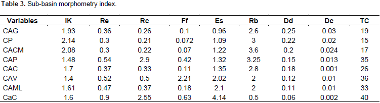
The elongation ratio index (Re) correlates best with basin hydrology (Lopez Bermudez and Romero Diaz, 1988). Values lower than 1 correspond to elongated basins and the smaller they are, the more elongated their shape is. Re emphasizes the relationship between area and mainstream. All subbasins within the study area were found to be elongated as their Re values are all less than 1. Differences can still be noted between them, however. The Guamini, Pescado, Cura Malal and Corto basin display the lowest values which range between 0.3 and 0.37. These subbasins are located in the eastern part of the drainage basin and are also the widest in area. It should also be noted that their channel banks are free of cliffs and their courses are meandering. These values corroborate Senciales’ (1999) findings that lower index values are typical of areas where meandering is well developped and slope gradients low. The Cochicó basin sets itself apart by displaying a value of 0.9 which is evidence of an almost circular shape. Values for the Arroyo Venado and Pigüe basins lie in the medium range which might be related to a rounder shape upstream and elongated in the middle and lower sections.
The shape factor (Ff) is very low, ranging between 0.07 and 0.6 for all cases except the Arroyo Venado basin (Table 3). This implies an overall trend towards elongation and low probability of peakflow events. Based on this index, it is unlikely that one of these subbasins would experience a rainstorm event over its entire area. This remains a general assumption though as the area affected by a storm depends on the latter’s size, extent, duration and intensity, as well as characteristics of the event. The Pescado, Corto and Cura Malal subbasins display the lowest values by being the most elongated and thus the least likely to have their entire area affected by a single storm.
The circularity ratio (Rc) is defined as the relationship between basin area and that of a circle of equal perimeter. The lowest values are found in the eastern section of the basin and belong to Pescado, Corto, Cura Malal and Guaminí subbasins. These units display the lowest circularity, a morphometric characteristic which is unlikely to intensify peakflow events. It can also be inferred that torrentiality is greater within the tributaries rather than in the main channel at their points of confluence.
As for mainstream length, the longest is the Corto (Table 2) whose tributary network is also the longest (533 km). The shortest mainstreams are Malleo Leufú (16.6 km) and Cochicó (20.14 km). The shortest network is the Cochicó‘s to which no tributaries are connected.
A drainage network is a hierarchized system of streams that takes into account all orders and junctions of tributaries connected to a mainstream. It plays an important role in the transport of materials and energy. The subbasins’ drainage network varies from third to fourth order which indicates a low level hierarchy. The basin with poorest drainage is the Cochicó, of first order. Those of highest order (fourth) are the Guaminí and Corto basins. The Pigüé, Malleo Leufú, Pescado and Cura Malal basins are of third order and the Venado of second order. The network pattern or ramification shape is dendritic to sub-dendritic, however parallel to sub-parallel is also developed locally. In the widest basins, this pattern tends to occur above 600 m amsl.
Drainage density (Table 3) is defined as the relationship between stream length and total area. This parameter is used to describe basin regime and morphology (Sanchez, 1991). In general, magnitude is indirectly related to soil cover, erosion, lithology and infiltration. Areas of permeable rocks typically display low drainage density. The study area’s basins posess a very low drainage density, including some extreme cases like the Cochicó which exhibits a value of 0.06 km/km2. This may be caused in part, first, by the coarse texture of its silty and sandy alluvia (INTA, 1994) which are rich in organic materials and are characterized by large interstitial pores, thereby increasing water infiltration. Sands are also permeable enough that input to nearby streams is minimized. Land-use being mostly agricultural, the vegetation cover also promotes water infiltration and reduces runoff. Once a rainfall is over, roots absorb soil humidity and increase the capacity for infiltration in-between rain events. The low drainage density indicates that basin response to a rainstorm is likely to be slower for evacuating excess water than basins with a higher density. However, when water reaches streams of low ramification and hierarchization, this may cause a rapid rise in waters and waves of peakflow events all the way to the stream outlet.
In terms of bifurcation ratio, subbasins displaying the lowest values are Venado, Cochicó and Malleo Leufú (Table 3) while the remaining are all higher. With regards to the Encadenadas, the rounder the drainage basin, the higher the bifurcation ratio and the more elongated the basin, the lower it is. This can be explained the following way: elongated basins tend to delay the concentration of water due to the longer length of their mainstream. However, when that threshold is reached, waters may start to rise suddenly and rapidly (Gonzáles Matauco, 2004). Thus, the fact that elongated basins display the lowest bifurcation ratio results from the length of their mainstreams which delays the concentration of waters, further enhanced by low gradients (1%) in the basins’ middle and lower sections (Senciales, 1999).
Concentration time is defined as the time required for a water particle to travel from the furthest point to a specific point. It corresponds to the time elapsed between the end of a rainfall event and the time when surficial runoff ceases (Fuentes Junco, 2004). Concentration times in the Encadenadas are long in the rounder basins (Pigüé, Venado and Cochicó) with values of 35, 36 and 40 min respectively.
Basin topography was analyzed using the digital elevation model (Fig. 3). Elevations within the study area are comprised between 82 m amsl (lowest elevation) of the western Epecuén lake and 1015 m amsl (highest elevation) where the mainstreams that drain the Ventania’s main basins take their source. The difference in altitude between these two extremes characterizes a relief whose elevations and slopes are likely to be significant and thus favour the development and activation of erosive processes and transport of materials. It should also be mentioned that the highest elevations lie southward of the basin and the lowest ones, northward. The remaining landscape lies below 400 m amsl. The mean slope of the mainstream is an important parameter for determining hydrological behaviour in a basin. Basins with a steeper slope are characterized by faster runoff and respond more rapidly to rainfalls, therby increasing discharge at any given point (Horton, 1945). In basins of greater elongation and lower gradients, water circulates more slowly along longer channels in-between sources and outlets.

Due to the higher declivity between stream sources and outlets in the western part of the basin, cliffs have developped along the channel banks of streams such as Pigüé et al. (Figure 3) whose mean slopes are steepest (Table 4). The Cura Malal, Pescado and Corto streams exhibit slopes below 0.18, 0.02 and 0.01 respectively. Consequently, streams located to the east of the basin respond faster to rainfalls than those to the west. The headwaters sector is influenced by the presence of mountains which cause mean slope values to reverse. The Corto, Pescado and Cura Malal streams exhibit the steepest mean slopes, the highest levels of ramification and the most cliffs. This is explained by the range’s curved shape (Figures 2 and 3) whose elevation decreases towards the northwest where the sources of Pigüé and Guaminí streams lie.

Altitudinal difference is the difference between the highest and the lowest elevation point of a basin and influences climatic and ecological variability. A basin with a greater number of altitudinal surfaces is likely to harbour more ecosystems as a result of important precipitation and temperature variations (Junto, 2004). Table 4 sums up altitudinal differences including and excluding the nearby mountain topography. Based on this data, the Cura Malal, Pescado and Corto subbasins exhibit the greatest climatic and ecological variations.
The massivity index (Cm) indicates that for each square kilometre within the basin, there is a mean increment in elevation of 0.35 m, a typical value for basins whose relief are for the most part flat. This parameter is thus an indicator of increments in slope as elevation increases. The Cm index may also reflect erosion prone basins, the most vulnerable ones being the smaller ones who display higher coefficients versus the larger ones whose values tend to be smaller. According to Llamas (1993), the hypsometric curve is the most precise rendition of a basin’s elevation. Hypsometry analysis (Figures 4 and 5) demonstrates that the highest section is that of steepest slope and also the most restricted in area. During wet periods, water precipitations in the mountains are thus likely to result in intense runoffs above 400 m amsl. Erosion processes in that area are more important and render the implementation of appropriate agricultural practices essential. It can be noted that the basin’s hypsometric curve, excluding the mountain range, comprises a gentle slope below 300 m amsl. The altimetric frequency histogram reveals that only 5% of the basin lies above 350 meters which corroborates the DEM analysis. As part of the targeted morphometric analysis, the following presents results from each subbasin’s hypsometric curve and histogram analysis.


The Pigüé Basin mostly comprises (78%) of elevations ranging between 200 and 300 m. The highest lands make up only 1% of the basin area and are where the Pigüé stream source lies (Figure 6a). Its topography is smooth which corroborates well with its almost straight hypsometric curve (Figure 7a). This is also evidenced by the agreement between the mean elevation and the elevation frequency mean.


Figure 8 illustrates the typical phases of basin erosion cycle and potential evolutionary scenarios as put forth by Strahler (1974). Based on his model, the Pigüé basin has reached an intermediate phase, between relative equilibrium or “maturity”, and “old age”, evolving towards the latter. At that stage, its morphodynamic potential for undergoing erosion and mass slumping of its slopes is low.

The Venado sub-basin covers 293 km2, has a perimeter of 85 km and a mean slope of 2%. Of the lesser subbasins, this one has the greatest mean elevation (Table 5) which is worth considering since it has an influence on runoff and erosion processes. Predominant elevations range between 150 to 200 metres followed by 95 to 150 metres amsl (Figure 6b). Its hypsometric curve (Figure 7b) increases as it reaches the basin’s predominant elevation values. It does not fit well any of Strahler’s models (1974) though as it is located between two active subbasins both in evolutionary states and has two alluvial cones resting on its margins, all of which suggest a subbasin in a state of disequilibrium evolving towards “youth”.

The Guaminí sub-basin exhibits a regular slope which is evidenced by its fairly straight curve (Figure 7c). Within the erosion cycle, it has reached the equilibrium state or “maturity” which is characterised by sediment and water transport. Its altimetric frequency histogram (Figure 6c) denotes the predominance of elevations between 200 and 250 m amsl which encompass 67% of its total area with another 3% located above 400 m.
The stream that drains the Malleo Leufú basin is of intermittent character and its channel the shortest in length (16 km). This is a typical plain stream, winding, its course interspersed with meanders where it migrated to connect to the outlet. Its banks are free of cliffs and allow this shallow channel to easily overflow its banks in response to increases in discharge. Its basin is 270 km2 in area with a perimeter of 94 km and a slope of 2%. The altimetric frequency histogram (Figure 6d) indicates that 52% of elevations lie between 95 and 150 m. Its hypsometric curve is asymetric (Figure 7d) given that the mean elevation is lower than the 175 m amsl median. This illustrates the prevalence of low lying areas in the basin over higher ones. Its hypsometric curve is overall convex which suggests an important potential for erosion and according to Strahler’s (1974) model corresponds to the disequilibrium or “youth” stage indicating the area is primarily a source of sediment and water.
The Cochicó stream which drains the equally named basin is the second shortest stream of the Encadenadas, being 20 km in length from source to outlet. Its channel is fairly straight for that of a plain stream. It’s discharge decreases during droughts to the point where it may completely dry out, defining it as intermittent. The basin is 333 km2 in area, 1% in slope and has a mean elevation of 155 m amsl. The frequency histogram (Figure 6e) shows that elevations ranging from 95 to 150 m are prevalent and that low lying areas are more extensive than those at higher altitudes (200 - 250). Its convex shaped curve displays a negative asymmetry (Figure 7) whose mean equals to 175 and its median 155 m amsl. It has reached the youth phase of the erosion cycle indicating a high morphodynamic potential for erosion processes to take place.
The 106 km long Cura Malal stream runs through a diverse landscape of mountains and plains and drains into Alsina Lake. Its middle section which lies over a plain is characterized by meandering. This basin, 829 km2 in area, is comprised of a diverse range of elevations with an almost symmetrical frequency as shown in Figure 7f.
Areas lying above 400 m make-up only 5% of the total. The altimetric frequency histogram (Figure 6 f) highlights the basin’s symmetry and shows most area falling in the 200 to 300 m range. It has reached an equilibrium state, evolving towards maturity.
The Pescado Basin covers a 791 km2 wide area. Its histogram (Figure 6 g) shows a less symmetrical distribution than the previous one. Higher grounds only represent 1% of the total area where altitudes ranging from 150 m to 250 m amsl prevail. Mean elevation in the basin is 222 m. Its properties are similar to the Cura Malal’s nevertheless, its hypsometric curve (Figure 7g) is slightly more pronounced thereby reflecting the steeper terrain. The basin has reached the “maturity” stage characterized by sediment deposition (Strahler, 1974).
The Corto Basin extends over 2 893 km2 making it the Encadenada’s widest subbasin. Its mainstream, 160 km in length, is also the longest and its relief, the system’s highest as it has the widest surface covered by mountains even though it amounts to only 8% of the total. This is the Encadenada’s easternmost subbasin displaying a difference of 72 m in elevation with the Pigüé subbasin (westernmost). The altimetric frequencies histogram (Figure 6 h) shows a uniform distribution and variation in elevation. Its hypsometric curve (Figure 7 h) is much steeper than that of the smaller basins (Venado, Malleo Leufú and Cochicó) and displays a positive asymmetry due to its mean elevation, lower than the 275 m median. This basin is in its maturity phase during which sediment deposition prevails (Strahler, 1974).
A principal components analysis (PCA) was carried out on the basins’ calculated morphometric indices so as to order them. The graphic in Figure 9 corresponds to a projection of the initial variables on a two-dimensional plane delineated by two axes. Axis one correlates with shape indices and axis two, with drainage and area. The correlation matrix (Table 6) shows that the first three components explain 87 % of the variance. Pigüé, Venado, Malleo Leufú and Cochicó subbasins are grouped together as they all display a strong positive correlation with the first principal component. Similarity between them is due to their rounder shape and longer concentration times.


As can be observed, the second principal component correlates positively with area, drainage density and concentration times. The group formed by Pescado, Cura Malal and Guaminí is characterized by larger areas, greater drainage densities and shorter concentration times. The Corto basin sets itself apart by exhibiting a strong positive correlation with the second principal component. This is to be expected as the Corto basin is the widest in terms of area and its mainstream, the longest.
CONCLUSION
This study’s aim was to define for the first time the various drainage subbasins that comprise the Encadenadas del Oeste’s basin. The characterization of these units shows that the basin is morphologically diverse due to the dynamic fluvial activity that prevails within its limits. One of the above mentioned morphological units are the alluvial cones which form atthe mouths of the mainstreams and delineate the bases of the different subbasins. Units designated “lesser” subbasins by this study are in a phase of disequilibrium or “youth” and therefore are actively being eroded. These basins are smaller in terms of area and their mainstreams shorter. Their hypsometric curves are negative and asymetric due to the mean elevation being lower than its median. The subbasins whose sources are located in the mountains have reached a state of equilibrium refered to as “maturity” or “old age” by Strahler, indicating that transport of water and sediment is the predominant process. These subbasins also display a positive asimetric curve. Corto and Pescado set themselves apart by being the only two basins to have reached the “old age” phase.
With regards to the shape index, the Venado subbasin is characterized by an oval outline, the Cochicó and Malleo Leufú an oblong one, while the rest are significantly elongated. The Pigüé and Venado basins are the most compact and circular indicating that rises in water are also likely to result in greater discharges at their mouths. Their steeper topography favours the rapid concentration of waters which is corroborated by the occurrence of cliffed banks along their mainstreams’ channels.
The drainage network exhibits overall a low level of ramification and hierarchy which is likely due to the sedimentary nature and high permeability of the soil below. The vegetation cover (crops are cultivated year-round) may exacerbate the restricted ramification which could provoke a rapid swelling of its waters downriver.
Concentration times are short in all of the basins. The Cochicó and Venado exhibit the highest values at 40 and 36 min respectively. These basins’ roundness considerably lengthens the time needed for water to flow from their edges to their mainstream and may end up concentrating the discharge downriver. The Corto, Pescado and Cura Malal display the shortest concentration times given their significant elongation which has water flowing through a shorter area before reaching the subbasins’ mainstreams.
Principal components analysis ordered the subbasins into two groups. The first one includes Pigüé, Venado and Malleo Leufú subbasins. Rounder rather than elongated, they have longer concentration times. This means that there may be some delay for stormwaters to reach their mainstreams but that once they are channelized, their discharge may swell considerably downriver, more so because of these basins’ steeper topography. This fact is extremely important as Carhué, a resort town, is located nearby. The second group includes Pescado, Cura Malal and Guaminí basins to which the Corto basin can be added as only its larger area sets it apart. These basins’ shape is elongated, their streams long and straight thus lengthening the distance from source to outlet. Low declivity and the absence of cliffs allow these streams to easily overflow their banks during rainstorm events. Rapid swelling of stream waters is uncommon in these subbasins and easily forecasted.
Two facts need to be taken into account as part of any land-use plan or major intervention in the area. Not only do both mainstreams from the Malleo Leufú and Guaminí basins drain into the same lake, but they also do so at a short distance from one another. In the event of a rainstorm occuring over both subbasins, fairly similar concentration times (19 and 33 min) will have the increased discharge of waters from both subbasins reaching the lake at a short distance from the town of Guaminí. The same could occur at the mouths of Cura Malal and Pescado streams which also both drain into Alsina Lake. Although no towns are located nearby, a number of farms are.
CONFLICT OF INTERESTS
The authors have not declared any conflict of interests.
REFERENCES
|
Capitanelli R (1998). Geografía Física y Medio Ambiente. Vol. 1-Ed. Mendoza. Ecogeo. |
|
|
Carbone ME, Piccolo MC (2002). Morfometría de la cuenca del arroyo Claromecó. Provincia de Buenos Aires, Argentina. Revista Geofísica. Instituto Panamericano de Geografía e Historia 56:51-66 |
|
|
De Francesco FD (1971). Geología superficial del área pedemontana del flanco Sudoccidental de la Sierra de la Ventana. Prov. Buenos Aires. Com. Invest. Cient., Reunión Científica. La Plata. |
|
|
Dillon AA, Hurtado MA, Jiménez JE, Castillo RJ (1985). Consideraciones geomorfológicas y estratigráficas como base del carteo de suelos en un sector de la Pampa Arenosa (Pcia. De Buenos Aires). 1as. Jornadas Geológicas Bonaerenses, Actas, Tandil, CIC, pp. 737-749. |
|
|
Doffo N, Bonorino GG (2005). Caracterización morfométrica de la cuenca alta del arroyo Las Lajas, Córdoba: Un análisis estadístico. Revista de la Asociación Geológica Argentina 60(1):16-22 |
|
|
Fidalgo F, De Francesco F and Pascual R (1975). Geología superficial de la llanura Bonaerense. En: VI Congreso Geológico Argentino. |
|
|
Fuentes JJJA (2004). Análisis Morfométrico De Cuencas: Caso De Estudio Del Parque Nacional Pico De Tancítaro. Dirección General de Investigación de Ordenamiento Ecológico y Conservación de Ecosistemas Instituto Nacional De Ecología. P. 47. |
|
|
Gardiner V (1974). "Drainage basin morphometry". Bristish Geomorphological Research Group. Technical Bulletin Nº 14. University of East Anglia. England 44 p. |
|
|
González de MAI (2004). Análisis Morfométrico De La Cuenca y de la Red De Drenaje del Río Zadorra y sus Afluentes Aplicado a la Peligrosidad de Crecidas. Dpto. Geografía, Prehistoria y Arqueología Universidad del País Vasco. Boletín de la A.G.E. 38:311-329 |
|
|
Hernández E (2002). La cuenca hidrográfica. FCFA. Universidad de los Andes. Mérida – Venezuela. |
|
|
Horton R (1945). Erosional development of streams and their drainage basins: Hydrophysical approach to quantitative morphology. Geolog. Amer. Bull. 56:275-370. |
|
|
Instituto Nacional de Tecnología Agropecuaria (INTA) Secretaría de Agricultura, Ganadería y Pesca. (1994). Atlas del Suelo de la República Argentina, Tomo I Buenos Aires 525 p. |
|
|
Isla FI, Ruiz Barlett E, Marquez J, Urrutia A (2003). Efectos Enso En La Transición Entre El Espinal Y La Pradera Cultivada En La Diagonal Sudamericana, Argentina Central. Rev. C&G 17(1-2):63-74 |
|
|
Lexow C (2002). Hidrodinámica de la zona no saturada aplicada al estudio del Balance Hidrológico y de contaminantes de los recursos hídricos subterráneos (Cuenca del Arroyo del Aguila). Tesis Doctoral en Geología. Universidad Nacional del Sur. Bahía Blanca. Argentina 175 p. |
|
|
Linden SVD and Woo MK (2002). Transferability of hydrological model parameters between basins in data-sparse areas, subarctic Canada-Elsevier - J. Hydrol. 270 (2003):182-194. |
|
|
López Bermúdez F, Romero Díaz MA (1988). Relación entre escorrentías superficiales y características físicas y ambientales (Alto Guadalquivir). En Avenidas fluviales e inundaciones cuenca del Mediterráneo. Alicante, Instituto Universitario de Geografía de la Universidad de Alicante. Caja de Ahorros del Mediterráneo, pp. 171-183. |
|
|
Luo W, Howard A (2005). Morphometric analysis of Martian Valley Network basins using a circularity function. J. Geophysical Res. 110: E12S13. |
|
|
Llamas J (1993). Hidrología general. Universidad del Estado de México. Toluca. México 627 p. |
|
|
Martinez JS (2001). The geology of Ventania (Buenos Aires Province, Argentina). J. liberian Geol. 27:43-69. |
|
|
Miller VC (1953). A quantitative geomorphic study of drainage basin characteristics in the Clinch Mountain area, Virginia and Tennessee. Office of Naval Research, Geography Branch, Project NR. Technical Report, 3, Columbia University. pp. 389-042 |
|
|
Munguía S, Campo de Ferreras AM (2003). Características Hidro-Geomorfológicas De La Cuenca Del Arroyo Pescado Castigado. Buenos Aires. Argentina. Papeles de Geografía 38:137-150. |
|
|
Navarro E, González UM (1998). Geomorfometria aplicada a la gestión hídrica del ecosistema de las lagunas Las Encadenadas del Oeste. Revista del Instituto de Geología y Minería 12(1):35-49 |
|
|
Sánchez T (1991). Estudio morfoclimático del CabeVó D’OR. Universidad de Alicante. Espa-a. 69 p. |
|
|
Schumm SA (1956). Evolution of Drainage Systems and Slopes in Badlands at Perth Ambos, New Jersey. Bull. Geol. Soc. Am. 67:646. |
|
|
Senciales JM (1999). Redes fluviales. Metodología de Análisis. Estudios y Ensayos, 34. Universidad de Málaga, 337 p. |
|
|
Silva A, Herpin U, Martinelli L (2006). Morfhometric Characteristics of seven messo-scale river basins in state of Sao Paulo (Southestern Brazil). Caminhos de Geografia. 3(17):20-30. |
|
|
Sione W, Cuello A, Angelini M (2004). Análisis Espacial, Técnicas cuantitativas aplicadas. Curso 9. Especialización en Teledetección y Sig. Universidad Nacional de Lujan. |
|
|
Strahler A (1952). Hypsometric (area-altitud) analysis of erosional relief. Bull. Geol. Soc. Am. 63:1117-1142. |
|
|
Strahler A (1968). Quantitative Geomorphology. En: R. Fairbridge (ed.). The Encyclopedia of Geomorphology. Encyclopedia of Earth Sciences Series, T. 3. Dowden, Hutchinson & Ross. Pennsylvania-USA. 912 p. |
|
|
Strahler A (1974). Geografía física. Ediciones Omega, S.A. Barcelona, Espa-a. 765 p. |
|
|
Strahler A (1985). Geografía Física (7a.ed.). Editorial Omega, S. A. Barcelona – Espa-a. 567 p. |
|
|
Uriarte González M and Orioli G (1998). Carta Geoambiental del Partido de Guaminí. Editorial Universidad Nacional del Sur. Bahía Blanca. Argentina. |
|
|
Yrigoyen MR (1975). Geología del subsuelo y plataforma continental. Relatorio 6º Congreso Geológico Argentino: 139-168. Bahía Blanca. |
|
|
Zarate M, Rabassa J, Partridge T, Maud R (1995). La brecha Cerro Colorado (Abra de la Ventana, Buenos Aires): ¿Es miocena? Actas de las Cuartas Jornadas Geológicas y Geofísicas Bonaerenses, Junin, 1:159-167. |
|
Copyright © 2024 Author(s) retain the copyright of this article.
This article is published under the terms of the Creative Commons Attribution License 4.0


