Agriculture is facing a lot of challenges even though, it is the principal source of food and livelihood in Nigeria. Among these challenges are neglect of the sector from the governments, land tenure insecurity and changes in agro-ecology, poverty and inadequate technical know-how of our farmers and land degradation as well. Land degradation refers to reduction in the productive capacity of land or its potential for environmental management (Scherr, 1996; Cofie and Pennig de vries, 2002). There are several causes of land degradation in Nigeria most of which are due to excessive human pressure and poor land management. These include continuous and clean cultivation, overgrazing of the range land, water logging and salinization, inappropriate agricultural techniques such as use of the heavy equipments on fragile soils, poor civil engineering practices, deforestation and soil erosion (Titilola and Jeje, 2008). Erosion is the most common form of land degradation affecting soil productivity in Nigeria (Phillip et al., 2008; Titilola and Jeje, 2008). Five principal types of soil erosion have been identified in Nigeria, namely sheet erosion, rill erosion, gully erosion, coastal erosion and wind erosion (NEST, 1991). Erosion has far reaching effect on the earth surface and therefore on man. It main effect is loss of soil nutrient and actual soil loss. Soil loss due to erosion prompted by poor land use practices could be as much as 15 tons per hectare per year on bare ploughed soil in western Nigeria (Titilola and Jeje, 2008) thus, about 850,000 ha of land are badly affected annually or rendered useless for agricultural purposes and human settlement. A part from soil loss, erosion drastically affected the physico-chemical properties of the soil still left in situ. The soils suffered a significant depletion of clay in the A-horizon, metallic cations, organic carbon, nitrogen and available phosphorus as well as cations exchange capacity (Titilola and Jeje, 2008). Soil erosion limits land utility which adversely affects food supply and food security at national and house hold level. The present study therefore, aimed at surveying the types of erosion prevails in Zamfara central senatorial district, their cause, effect and some of the measures adopted by the farmers in soil and water conservation.
Socio-economic characteristics of the farmers in the study area
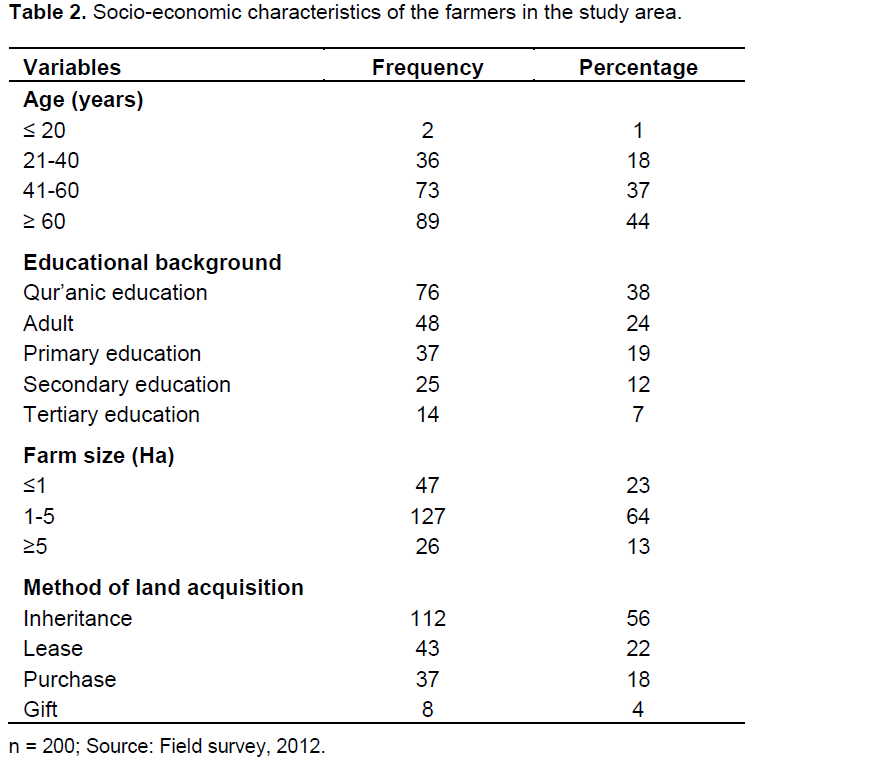
The data for this study reveals that the farmers in the study (Table 2) were between the ages of less than 20 to 61 years and above with latter having the majority (44%) which can be due to the fact that peoples of this age are house holders thus, farming becomes necessary as a major means for the provision of food to their family. Also peoples at this age are retired civil servant hence are into full time farming activities. 37% of the farmers were at ages of 41 to 60 years and 18% were at ages of 21 to 40 years which is revealing that the youth and peoples of middle age apart from educational pursuant, civil service and other business do engage into farming hence it serve as a part-time activity which is normally done during weekends/free market days. 1% of the respondents were at ages of 20 years and below which may be due to the fact that children under this category are mostly in schools and those not in schools are only providing labour for their fathers.
The educational qualification of the farmers in the study area ranged from Qur’anic education which is the most dominant (38%) to tertiary education which is the least having only 7% of the total respondents. Between these are adult education (24%), primary education (19%) and
secondary education (12%). This reveals that majority of the farmers in the study area had no/inadequate formal education hence it may be a very difficult for them to accept and adopt a new farming/soil management techniques they rather see any innovations brought to them as a means for imposing tax by the government. The consequence of this, is the continuous practicing the old and primitive farming techniques which can lead to improper soil managements resulting to decline in fertility and productivity of the soils.
The farm sizes of the farmers in the study area ranged from less than 1 ha (23%) to 5 ha and above (13%) with farmers having 1-5 ha constituting the majority (64%). This shows that farmers of the study area were small holders practicing subsistence farming which is mainly for family consumption with little/no farm produce given out for sale hence, mostly cultivate cereals which exhaust the little nutrients reserve of our soils and if not supplemented led to the soils to become low in organic matter and fertility.
Inheritance is the major land acquisition method in the study area amounting to 52% of the respondents. This leads to small land holdings due to fragmentation of the farm land which consequently resulting to too much pressure on the land and in degradation (Dalhatu and Garba, 2012). Lease, purchase and gift both as methods of land acquisition in the study area have 22, 18 and 4% respectively. Leased land usually is not receiving any organic amendments in the study area because the land is given out as lease for just one or two years hence those hiring the land see it as waste of resources to put what you cannot harvest thus, they only apply inorganic fertilizers alone which is having the consequences of declining soil organic matter leading to poor soil structure and chelation resulting to greater susceptibility of the soil to erosion.
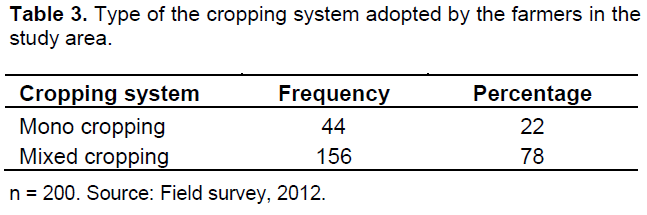
Table 3 present the types of cropping system adopted by the farmers in the study area. Majority (78%) of the farmers are practicing mixed cropping which is usually cereals/cereals (sorghum/millet) with some mixing legumes with cereals (millet/cowpea, millet/groundnut, sorghum/cowpea, maize/cowpea), legumes with fibers (cowpea/cotton) and legumes with legumes (groundnut/cowpea). 22% of the respondents are practicing monocropping and the crops usually planted includes maize, millet, sorghum, groundnut and cotton. This reveals that only few farmers in the study area are practicing recommended cropping system of cereals/legumes to our soil the rest are only exhausting the soil nutrients leading to its degradation.
Soil erosion types and severity in the study area
Rill erosion is the prevalent on 98 (48%) farm sampled for this study; this is because the small rills/channels can easily be detected from the farms. 54 (27%) of the farm sampled (Table 4) were having gully erosion which is the advance stage of water erosion resulting expansion of
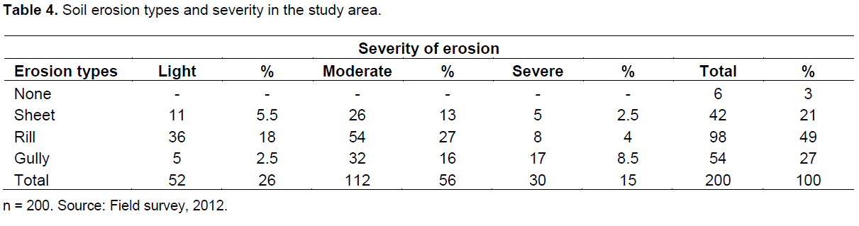
rills to a level where crop cultivation is impossible on that particular land as well as movement of farm machineries leading the land to be abandon. 42 (21%) of the farm lands experienced sheet erosion which may be due to the difficulty faced in its noticing as it involved uniform removal of soil by the flowing water (Michael and Ojha, 2010). 6 (3%) of the farm sampled recorded no occurrence of erosion which could be attributed to the presence of their farm on relatively flatty hence the major types of erosion affecting such types of land are usually splash and sheet which very difficult to detect as they occur along with the onset of rainfall and their consequences cannot be easily observed. On the severity of erosion in the study area moderate erosion is the dominant (56%), least erosion constitute 26% while severe types account for 15% of the farm land sampled. This is in line with Dalhatu and Garba (2012) who reported moderate erosion as dominant type in Gusau. Similarly, Tarfa et al. (2005) reports on the severity of erosion in Zamfara ranging from moderate (36.7%), light (11%) and severe (9%).
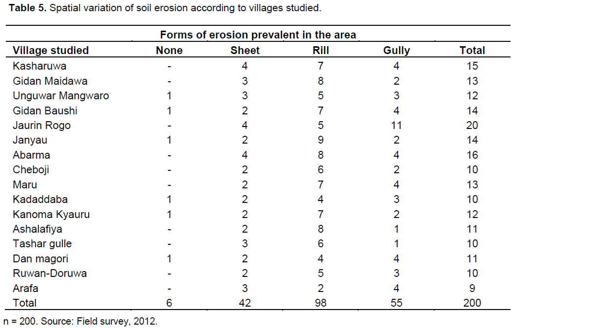
Spatial variation of soil erosion according to villages studied
The data presented in Table 5 shows that 98 (49%) farmers of 16 villages studied has rill erosion, 54 (27%) has gully erosion and 42 (21%) has sheet erosion on their farm while only 6 (3%) out of the total respondents do not observed the presence of any types on their farm. Sheet erosion is the detachment and uniform removal of soil along with flowing water. The gradual and continuous removal of these soil particles along with flowing water results into the development of narrow channels on the soil body hence rills. Gullies are the advance stage of the rills hence the channels increases in size and shape to stages that impede crop cultivation. The consequences of these are the detachments of soil mass usually soil surface there by exposing the lower unproductive horizon, losses of soil nutrients, leaching, lowering water infiltration and retention capacities of soils, and impeding water transportation due soil deposit in streams and rivers which can also lead increased flood hazard.
Detection of soil erosion by the farmers in the study area
Famers of the study area reported various sings indicating the occurrences of soil erosion (Table 6) from their farm lands. Declined in productivity of their farm lands is the major (33.5%) sign of erosion from the sampled farm lands as farmers interviewed reports that in almost every subsequent farming season they do record low yield from their farm holdings. 29% of the respondents detect the presence of rills and gullies from their farm signifying the occurrence of soil erosion. 22.5% of the farmers in the study area do observed a greater of their crops grown on black soil than those on grey, whitish or red soils hence nutrient depleted from the soil in order of red>white>grey>black soils. Formation of tree mould in the sampled farm lands was also reported (5.5%) as a sign of erosion in the study area which is due to litter and root presence around the trees hence increases soil organic matter and consistency around the tree resulting to soil resistance to striking forces of water and wind but soils on the bared land contains low/no organic matter thus water or wind found it so cheap to wash them away
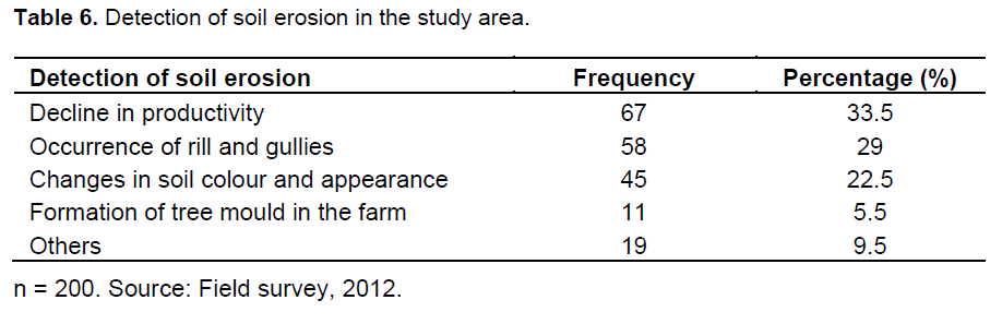
hence very prone to erosion. 19 (9.5%) of the total respondents reported other sign of erosion to includes formation of amour layer and pedestals.
Causes of soil erosion according to the farmers of the study area
Majority (23.5%) of the farmers in the study area reported (Table 7) the nature of topography of their farm lands as major cause of soil erosion. The topography of the soils is generally sloppy/steep slope resulting to greater movements of soil particles from the upper part of the slope and their deposition at lower part. Rainfall characteristic (19.5%) and heavy wind storm (17%) were reported as other causes of soil erosion in the study area. Convectional rainfall are the dominant type in North-Western Nigeria which normally comes higher striking forces, heavy thunder, lightning and wind leading to surface soil particles dislodgment, detachment and transportation via run-off or wind blow. Soil characteristics, clean and continuous cultivation, low vegetative cover and inappropriate land management practices both as causes of soil erosion in the study area have 9, 7.5, 14 and 5% respectively. The study area is from Sudan savanna agro-ecology with Alfisols as dominant soil types characterized by low organic matter and activity clay, poor structure and low bulk density making the soils very susceptible to erosion. Moreover, the vegetation of the area is very sparse with dominant grasses and the scattered trees present are deforested for the purpose of fire wood production the area generally bared thus, easily wash away by striking water or wind. Indiscriminate bush burning practiced in the study area and
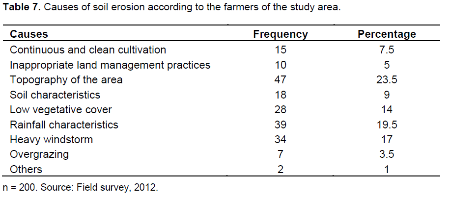
low/no fertilizer supplement leads to loss of nutrient and soil organic matter resulting to poor structure and texture of the soils and consequent soil erosion. 3.5% of the farmers in the study area reported over grazing as the cause of soil erosion on their farm land while 1% reported other causes which include flood, tillage and absence of soil conservation measures. Food and Agricultural organization (FAO) (1965) listed factors of soil erosion to include physiographic factors (slope steepness, length and curvature), climate (rainfall, wind and temperature), soil and cover or vegetation. Tarfa et al. (2005) also reported heavy run-off, heavy wind and poor agricultural practices as the main cause of soil erosion in Zamfara State.
Soil erosion as a constraint to sustainable crop production in the study area
Sustainable agriculture refers to the ability of a farm to produce perpetually base on long-term effects of various practices on soil properties and processes essential for crop productivity, and the long-term availability of inputs (Medugu, 2006). For achieving sustainable crop production various constraints need to be ratify and among other constraints include soil erosion which is particularly damaging the soil surface hence reduces soil quality and productivity. Soil erosion commonly occurs on farm lands though may not be noticed by farmers. Farmers often notice soil erosion when gullies developed in the farm and only then call for assistance (Kirchhoff and Odunze, 2003). Other erosional features include rills, pedestal, amour layers, changes in colour and appearance of soil as well as formation of tree mould which lead to the destruction of many arable and grazing lands, thereby posing vulnerability threats to environmental quality and food security. The main agent of erosion in the study area are water and wind thus wind and water erosion are the prevalent types which causes a lot of damage to crops and environment generally. Some of the damages caused by wind and water erosion in the study area are discussed below.
Loss of productive soil
The surface soil lost with runoff water consists of rich productive and fresh or active organic matter. These eroded materials which is ultimately carried into rivers, streams or reservoirs and thus lost consist of colloidal matter, nutrients, clay, silt and finest grades of sand resulted into exposing the lower unproductive horizon and the soil deposited is not only unavailable for agriculture but is definitely harmful.
Change in soil structure
This is the most serious damage caused by wind erosion. The smaller and loose soil particles are more subject to movement by wind. Wind erosion gradually removes silt, clay and organic matter from the surface soil, leaving the coarse materials behind. This sorting action removes the most important soil materials, from the stand–point of productivity and water retention. It leaves a sandier and less organic soil, more subject to erosion. This lead to the eventual soil condition wherein plant growth is rather impossible.
Soil deposition on productive field
In the plains, fertile lands have been made unproductive by the deposition of coarser materials brought by streams or rivers.
Soil blowing
Crops, particularly in the seedling stage, are often damaged by abrasion of windblown soil particles. Often, sufficient soil is removed to expose the plant root or un germinated seed resulting to a complete crop failure.
Silting
soil erosion from the catchments areas of rivers and streams, reservoirs, drainage and irrigation channels results in the deposition of soils, thus reducing the depth as well as their water storage/intake capacity resulting to overflow and flooding, also impede water transportation because of the shallow water table of the rivers.
Drifting
Soil particle carried by wind often buries and ruins established crops, fences, wells, ditches and channels. Insect and weed seed are blown far and wide with drifted soil, to infest clean fields.
Lowering of water table
With the increase in runoff, the quantity of water available for entering the soil is decrease (Michael and Ojha, 2010). This reduces the supply of water to replenish the ground water in wells and the yield of well is reduced.
Fragmentation of land
Gullies can divide the farm into many valleys and ridges. Farm lands thus become smaller, unproductive and scattered. Crop rows are shortened, movement from and within the farm is obstructed, and the farm value is decreased.
Erosion control practices adopted by the farmers of the study area
The most notable soil and water conservation practices adopted by the farmers in the study can be discussed below.
Cover cropping
This is widely practiced by the farmers sampled (75%) and it involved planting creepy crops like cowpea. The cover crops are primarily grown as a measure to control or reduce the soil erosion as it protects soils from splash erosion. Other importance of cover cropping includes; addition of organic matter into the soil through the roots and ploughed down of the top growth, enriching the soil with nitrogen by growing the legume crops through fixation, improving the physical condition of the soil and checking water and wind erosion.
Manure application
This involves application of any materials mostly of organic origin which when applied provides soil with nutrients and organic matter. This is practiced all by all farmers in the study area (92.5%). Manures help in improving soil structural stability, infiltration and water retention capacity which gives soil a strength/resistance to soil erosion. Manure also, improve cations exchange capacity and nutrient supply for crop uptake.
Mulching
This is practiced by 23.5% of the farmers in the study area. Mulching is any protective coverage resting on the soil aimed at preventing loss of water by evaporation, keeping temperature low and preventing soil erosion. Mulching also keeps down the weed grown; it protects the soil from direct ray of the sun, striking forces of wind and water thus, reduces surface runoff and ensures protection of soil against raindrop/wind impact by creating a protective layer between raindrop/wind and the soil surface. Mulch materials easily decompose to enrich soil.
Drainage
It is practiced by 89% of the sampled farmers and is the removal of excess water from the soil so as to facilitate ploughing and planting. Drainage also, improves soil aeration which favor’s growth and development of soil organism. It leaches excess salt from the soil as well as providing more available soil moisture and nutrients by increasing depth of the root zone.
Sand bagging
This is practiced by 55.5% of the respondents and it involves using bags filled with sand aligned at some peak runoff areas with a view to diverting the water from entering a farmers’ field. Farmers in the study area also use sand bags as land re-filling technique especially in the prevention and control of gully development. Moreover, re-filling the eroded lands is also done by the farmers of the study area so that the rills and or gullies developed could stabilize and heal. The common materials used for this practice include: Soil materials, solid wastes, corn stalks, and other crop residues.
Contour farming
This is practiced by 61.5% of the respondent thus, farmers in the study area make contour embankments and drainages in their fields and then make sure they make their ridges to follow the contour lines so that the eventual runoff is slowed as much as possible. Even though this method is effective only on gentle slopes, contour ridging as observed by Roose (1996) is twice as effective as simple contour tillage, reducing erosion to about 30% of that on the flat-tilled control plot for slopes of 1 to 8%. Similarly, tie ridging practice is also done by farmers in the study area to conserve water between ridges and to improve the lateral infiltration of water into the ridged soils. According to Odunze (2008), this technique also conserves soil eroded from the ridge within furrows in such a way that fertilizer materials are not readily lost from the tied-ridging zone.
Terracing
It is practiced by 34% of the sampled farmers and peculiar to the farmers of the hilly areas. It involves the construction of embankments or ridges and steps like structures across the land slope to check the flow of surface run-off and reduce the soil loss. In this system, the effective length of land slope is reduced to a large extent. In addition, terracing also plays an additional role of not only controlling the soil loss caused by sheet flow but also play an important role in trapping the splashed soil particles and depositing them over the benches. Terraces reduce the length of slope by splitting the slope length in different parts; it helps in soil and water conservation.
Earth bunding
It is practiced by 18% of the sampled farmers and is simply an embankment like structures constructed across the land slope. Bunding is used for retaining the water creating obstruction, it is important in controlling erosion and to store the rain water, it also disposes the excess water very safely to a suitable point.
Minimum/zero tillage
This is usually called “Kato huta” and implies the preparation of seedbed and other practices with minimum/no disturbance of soil. The following are the importance of minimum tillage; it provide a proper environment for the seed to germinate and germinated seedlings; it increase the water intake capacity of soil and thus to control the erosion; it reduce soil erosion and removing the weeds during minimum tillage operation.
This method even though not widely practiced (46%) by the farmers in the study area due to inadequate capital for the purchase of agro-chemicals it is becoming more acceptable to the farmers.
Strip cropping
This is practiced by 25% of the respondents and is a cropping technique practiced by farmers in the study area when a slope is too steep or too long, or when other types of farming may not prevent soil erosion. In this method for instance, farmer plants maize and legumes (Groundnuts or Cowpea) in alternate strips on the same piece of land. This measure ensures that the strips of legumes would check erosion and also improve soil quality, while in the alternate strip of maize next to the legumes, some soil loss may be experienced which is also trapped by the next alternate strip of legumes following the Maize.
Finally, other soil and water conservation techniques adopted by the farmers in the study are grassed water ways and diversion, avoidance of bush burning, avoidance of excessive grazing and tree planting for the establishment of wind break.