ABSTRACT
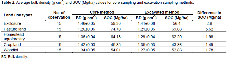
The different methods used for determining soil bulk density make the result of soil organic carbon (SOC) estimation vary. The study was conducted on five land use types in Gergera watershed, Tigray, Ethiopia. This study investigates two methods (Core and Excavation methods) of soil bulk density and their relative consequence on SOC; it also evaluates which method is better for estimating SOC stock. Both methods were undertaken in top 0 to 30 cm soil depth. For comparison of bulk density methods, statistical package for social science (SPSS) version 23 was used. The result revealed that using core method, SOC was 59.30, 74.70, 64.18, 45.35 and 54.61 Mg/ha in pasture land, homestead agroforestry, crop land and woodlot respectively. Whereas, land use types were scored 56.40, 69.08, 62.20, 43.86 and 52.83 Mg/ha in exclosure, pasture land, homestead agroforestry, crop land and woodlot respectively using excavation method of bulk density determination. Although SOC stock exhibits statistically significant difference among land use types in the bulk density methods, the statistical effect was not because of bulk density methods but because of other variables in the land use types. SOC of bulk density results and mean SOC difference in each land use types were calculated using core and excavation methods. In conclusion, soil excavation method of bulk density determinations used for SOC estimation is the lower standard error. Furthermore, this work provides new insights into improving the bulk density methods and assists in the accurate estimation of soil carbon stock management.
Key words: Bulk density methods, land use types, soil organic carbon stock.
Currently, soil carbon storage is generally expressed as a mass of carbon per unit area as recommended by the Intergovernmental Panel on Climate Change (IPCC). In measurements of bulk density, care should be taken to avoid any loss of soil from the cores (Pearson et al., 2007). Bulk density is one of the most important parameters used to calculate soil organic carbon (SOC) storage (Xu et al., 2016). To obtain an accurate estimation of SOC stocks in the mineral soil or organic soil three types of variables must be measured: soil depth, soil bulk density, and concentrations of organic carbon within the sample (Pearson et al., 2007). The main reason for high uncertainty of soil organic carbon stock results from the difference in bulk density methods (Dawson and Smith, 2007; Xu et al., 2015). It is described as the weight of dry soil for a given volume. It is used to measure soil compaction. Several methods can be used to determine bulk density of soils although the most commonly practiced methods are core method and excavation method.From Dane and Topp (2002), obtaining an unbiased measurement of soil bulk density is difficult, and different methods of measurement for soil bulk density yield different results.
Therefore, selecting best estimator of bulk density is important for soil carbon stock estimation. Accurate SOC estimation results from improved sampling methods. Recent concern over the effects of small changes in soil organic carbon has been encouraged to evaluate the accuracy of methods for quantifying soil carbon (VandenBygaart and Angers, 2006). Additionally, different soil conditions, sampling equipment, or techniques can cause unintentional biases in depth measurements and the method as well (Wuest, 2009). Different methods of bulk density result in different SOC storage under different land use types. According to the study by Petrokofsky et al. (2012), soil carbon represents the largest carbon pool of terrestrial ecosystems, and has been globally estimated to have the largest potentials to sequester carbon. However, there are numerous challenges of soil organic carbon estimation. There is need to monitor small incremental changes in soil carbon content relative to large carbon pools, long-time periods to accrue the full carbon benefits, high local variability of soil carbon content, and relatively costly soil carbon measurement procedures. Moreover, bulk density is one of the most important parameters used to calculate SOC storage (Wiesmeier et al., 2012).
Palta et al. (1969) reported several methods (core method, mercury displacement method, kerosene saturation method, kerosene displacement using water as impregnating liquid, coating the soil clods with molten wax of 65 and 100oC, coating the soil clods with collodion, coating the soil clods with rubber solution of varying dilutions and excavation method) that have been used for determining bulk density. However, the most common used methods are core and excavation methods in and around the study area. As a result, there is a need to select unbiased and best method of bulk density from the common methods to have an accurate information of soil organic carbon stock measurement in the different land use types. According to Sakin (2012), very strong relationship was determined between soil organic carbon stock and soil textural groups. Moreover, few studies have focused on the effects of bulk density methods on soil organic carbon stock and the accuracy of the different methods worldwide. Best estimator method of bulk density gives good estimation on carbon stock. Therefore, the study quantitatively evaluates the SOC stock estimated from different methods of bulk density.
Study area
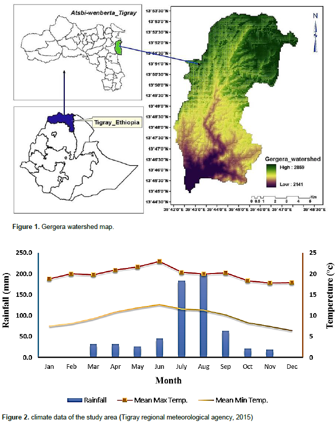
The study area, Gergera watershed, is situated in Atsbi-Wonberta District, Tigray regional state, Northern Ethiopia (Figure 1). It lies in the eastern part of Tigray, about 65 km North East of Mekelle, the regional capital of city of Tigray Regional State. Geographically, it is located between 39°30' to 39°45' E and 13°30' to 13°45' N. The total size of the watershed (study area) is an area of 2302 ha. Mean elevation of the watershed ranged from 2141 to 2859 meter above sea level, with minimum (2076) in crop land and maximum (2859) in exclosure. Farming system of the study area was dominantly subsistent involved on mixed crop-livestock production (Figure 2). Farmers of the study area do not integrate crop residues into the soil because of fuel wood and animal feed constraints, respectively. The study area experiences highly soil erosion and degradation through flooding and runoff from nearby exclosure, which is one of the main land degradation factors in the watershed. Livestock raring embraces cattle, sheep, goat and donkey. The main crops growing in the farming system were wheat (Triticum aestivum), maize (Zea mays) teff {Eragrostis tef), millet (Eleusine coracana), Faba bean (Viciafaba) and sorghum (Sorghum bicolor) with rotation year by year.
The soil type classification by its coverage in the study area is clay loam, loam, sand, sandy loam, silt and silt loam with total area of 25.8, 41.23, 741.1, 108, 1322.7 and 63.2 ha, respectively. The percentage was 1.08, 2.2, 32.19, 4.69, 57.45 and 2.74%, respectively. Some challenges in the study were climate change impacts like unseasonal heavy rainfall, rainfall interruption and others. The study area is faced with soil nutrient depletion due to continuous plowing of the cultivated lands. Continuous year by year application of chemical fertilizer may affect the soil structure and texture, not only on cultivated land but also on the other land use types; while repeated drought and weather fluctuation may damage the watershed. In the study area, governmental and non-governmental organizations have been working in the watershed to improve the livelihood standard of the community through climate smart agriculture.
Soil sampling methods
The time of soil sampling started from 12 October to 20 November, 2015. Soil samples were collected from exclosure, pasture land, homestead agroforestry, crop land and woodlot. Soil samples were taken from every sampling plot measured 20 × 20 m at each corner and center (Bajigo et al., 2015). A total of 75 representative soil samples were collected from soil depth (0 to 30 cm) (IPCC, 2006) on each land use types; 15 plots from the 75 experimental plots were taken out and mixed together in order to have approximately 1 kg composite sample. Soil samples for chemical analysis were air dried under shade, ground using pestle and mortar and sieved to pass through 2 mm to obtain fine fractions (Yitaferu et al., 2013). Undisturbed soil samples were also collected from the same plots of the land use types using core method and disturbed excavated method for determination of bulk density from each 75 soil samples.
Core method
Five land use types were selected in Gergera watershed, Tigray, Ethiopia for soil bulk density measurement. Using core method, soil samples were collected using a core sampler made from 5 cm height and 5 cm diameter metal cylinder pressed into the soil. The cutting edge was sharpened without disturbing the height of core. The cylinder is removed, extracting a sample of known volume which is 98.12 cm3. The moist sample weight is recorded. The sample is then dried in an oven and weighed. A total of 75 plots of undisturbed soil sample were collected from five land use types, 15 plots each (exclosure, homestead agroforestry, pasture land, crop land and woodlot) were taken from the land use types using core sampler for determination of bulk density. While taking cores for measurements of bulk density, great care was taken to avoid any loss of soil from the cores. The weights of dry mass of soil sample were determined after oven dried at 105°C for 24 h (Hunde, 2015; Kuyah and Rosenstock, 2015), till no further changes in weight occurred.
Procedures
(1) Carefully dig up to 0 to 30 cm then drive cylindrical core ring (5cm*5cm) horizontally in the middle of 0 to 30 cm that is, 12.5 to 17.5cm.
(2) Weigh the empty cylindrical core sampler.
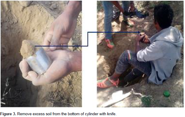
(3) Remove excess soil from the bottom of cylinder core sampler with knife as shown in Figure 3 and if not full, an independent measurement must be made to the volume of core sampler so as to measure accurate volume of soil.
(4) Close and pack the soil fill core sampler, label further sampled soil by known weight of the core sampler and record its total fresh weight.
(5) The packed soil fill core sampler was transported to the soil laboratory, oven dried at 105°C for 24 h (Hunde, 2015; Kuyah and Rosenstock, 2015), till no further changes in weight occur.
(6) Place a metal on each soil fill core sampler and carefully place in a plastic bag.
(7) Weigh the dry and undisturbed soil sampled by core sampler.
(8) Then bulk density is calculated by dividing the dry mass to the volume core sampler.

Excavation method
The excavation method entails digging a pit that is wide enough to collect the soil to the depth desired (Pearson et al., 2007) which is at least 0-30 cm in five land use types. A hand shovel can be used to collect material. It is important to collect material from the entire depth to avoid biasing the sample. Uniform rings were used to sample the sides of the pit for bulk density. Bulk density is determined on both the total soil and fine fraction (<2 mm). The fine fraction bulk density is critical when converting to carbon balance studies in soils with high coarse fragment content, since usually only the fine soil fraction is analyzed for carbon. The main disadvantage of the excavation method is more labor-intensive than simple coring. This method requires one to sieve out the course fragments greater than 2 mm in size, retain and weigh the weights recorded and deducted from the volume of the core.
Procedures
(1) Record empty core weights (CW).
(2) Prepare flat surface and dig a deep hole at required depth in sampling pit
(3) Press or drive core sampler into soil horizontally
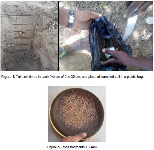
(4) Take soil sample using known height and diameter core sampler; in this case take six times (Figure 4) in each five cm of 0-30 cm and place all sampled soil in a plastic bag.
(5) At the laboratory, remove the soil from the plastic bags and air dried the soil then sieve the soil (breaking up the soil clumps only) to <2 mm fraction.
(6) If sample contains rock fragments > 2 mm, dry and weigh the rock fragments that are retained on the sieve (Figure 5). Record weight of rock fragments (RF). Determine density of rock fragments (PD).
(7) Oven-dry the <2 mm soil at 105°C for 24 h.
(8) Weigh the <2 mm fraction of soil
(9) Measure and record cylinder volume (CV)
(10) Determine the oven-dry weight of the sample and calculate bulk density.
Data analysis
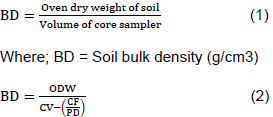
Bulk density by core sampling was determined using Lichter and Costello (1994) (Equation 1). Whereas, Excavation method of bulk density determination was analyzed using Pearson et al., 2007 (Eq.2). For the soil organic carbon stock estimation (Eq.3) Pearson et al. (2007) was also used.
Where:
BD: bulk density of the < 2mm fraction (g/cm3), ODW: oven dry mass of fine fraction < 2mm in gram, CV: Core volume (cm3), CF: Mass of the coarse fragment (> 2mm) in gram, PD: Density of rock fragment (g/cm3) or particle density given as 2.65g/cm3

Where;
%OC: is percentage organic carbon concentration expressed as decimal fraction, SOC: soil organic carbon stock.
Soil organic carbon stock
The main reason for higher SOC stock in pasture land could be the higher organic matter content and manure. Livestock graze on rotational basis, and dung of grazing animals leaves excretion which contributes to increased organic matter. In agreement with this study, Neill et al (1997) reported that soil carbon stock values were better in pastures than in the original forests. The low soil organic carbon content of the crop land could be attributed to continuous cultivation practice and removal of crop residue; decreased fallow due to shortage of land was reported by Ahukaemere et al. (2015). Other study conducted in Southern Tigray Ethiopia by Corral–Nunez et al. (2014), shows declining level of soil organic carbon in crop land soils under current agricultural practices due to the removal and free graze of crop residues after harvesting crop plants and use of manure as an energy source for cooking. Despite the reason for the statistical difference in soil organic carbon stock in the land use types, bulk density methods that cause change on the result of soil organic carbon stock in the land use types are discussed as follows.
Core method
Soil bulk density ranges among land use types between 1.26 and 1.46 g cm-3. The highest is in the exclosure and the lowest in pasture land. Statistically, soil bulk density shows significant difference among land use types (P < 0.05). In bulk density using core method of analysis there was statistically significant difference among land use types at P = 0.05. Exclosure (1.46±0.05) and crop land (1.42±0.03) have higher significant difference over pasture land (1.26±0.06) (P = 0.004 and P = 0.02 respectively). No significant different was found among exclosure, crop land, pasture land and woodlot (1.34±0.05) with homestead agroforestry (1.36±0.04). According to Hazelton and Murphy (2007), the rating of bulk density is < 1.0, 1.0 to 1.3, 1.3 to 1.6, 1.6 to 1.9 and >1.9 for very low, low, moderate, high and very high respectively. Therefore, the soil bulk density of the whole watershed was moderate. The result of soil organic carbon with their standard error using core method revealed that 59.30±3.95 Mg/ha, 74.70±9.95 Mg/ha, 64.18±6.42 Mg/ha, 45.35±3.30 Mg/ha and 54.61±6.76 Mg/ha, in exclosure, pasture land, homestead agroforestry, crop land, woodlot respectively. Statistically, soil organic carbon reveals significant difference among land use types (P < 0.05). Pasture land was significantly higher compared to exclosure, crop land and woodlot with their probability value of 0.036, 0.000 and 0.007 respectively. Similarly, homestead agroforestry was significantly higher compared to crop land in soil organic carbon stock.
Excavation method
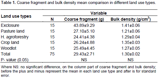
Bulk density using excavated method of analysis, there were no statistically significant differences between land use types (P < 0.05). However, the mean difference (mean ± standard error) in between was 1.41±0.06, 1.21±0.06, 1.29±0.04, 1.35±0.03 and 1.27±0.05 for exclosure, pasture land, homestead agroforestry, crop land and woodlot respectively (Table 1). According to Hazelton and Murphy (2007), the rating of soil bulk density of the whole watershed was moderate. Even though there was no significant different in coarse fragment of the land use types, exclosure has higher mean of 43.89 gram compared to pasture land (27.10 gram), homestead agroforestry (24.41 g), crop land (26.24 g) and woodlot (25.49 g) (Table 1)

Soil organic carbon stock estimation using excavated method of bulk density
Using excavated method of bulk density calculation there were significant differences in soil organic carbon stock between land use types (P = 0.002). Using excavated method, the organic carbon content varied from 43.86 Mg/ha to 69.08 Mg/ha. The result of this study indicated that pasture land (69.08 Mg/ha) has significantly higher amount of soil organic carbon over crop land (43.86 Mg/ha) (P=0.001) and woodlot (52.83 Mg/ha) (P=0.025); on the other hand, homestead agroforestry land use type (62.20 Mg/ha) reveals significant difference over crop land (43.86 Mg/ha) (P=0.012); whereas there was no significant difference detected between exclosure (56.4Mg/ha) and all the land use types; also pasture land and homestead agroforestry, between homestead agroforestry and woodlot and between woodlot and crop land.
Comparison of soil organic carbon stock results of the two bulk density methods
Bulk density methods are not only used for analyzing the estimation error of soil organic carbon stock, but also used for analyzing soil carbon concentration in laboratory. According to Venkanna et al. (2014), a relationship was established between Walkey–Black carbon and soil organic carbon stock estimated through dry combustion method using CN analyzer; and it was found that Walkley–Black carbon could recover 90% of soil organic carbon for semiarid tropical soils. Although there were no statistically significant differences among the two methods of bulk density there were mean difference between the methods (Table 2). Bulk density values established by excavation method were significantly lower compared to core sampling values (Lichter and Costello, 1994). The volume excavation method requires one to use simple and inexpensive tools, useful for sampling soils of various conditions; but this technique requires greater care in sampling technique, which increases the time required for sampling. Core sampling is a simple, fast and common technique, but is not suitable for sampling rocky, dry or wet soils (Lichter and Costello, 1994), Core sampling is the most common technique for measuring bulk density in agricultural soils.

It is difficult to determine the specific reasons for the difference in bulk density values generated by the two methods. The result revealed that, there was a difference between bulk density methods (core and excavation methods) and their effects on soil organic carbon stock result. Average bulk densities measured by excavation method were 4.9, 7.5, 3.1, 3.3 and 3.3% lower than those obtained by core sampling method in exclosure, pasture land, homestead agroforestry, crop land and woodlot respectively (Table 2). The average percentage difference in all land use types was 4.4 g cm-3. It is important to note that although the difference in bulk density values produced by the two methods is relatively small (3.1 to 7.5%), the implications of this difference in terms of soil organic carbon stock may be substantial. Variation of bulk density values within a method was generally low and differences between replicates at each site were not significantly different.
CONCLUSION AND RECOMMENDATIONS
Even though bulk density is the main parameter for calculating soil organic carbon stock, it is also one of the sources of uncertainty in estimating soil organic carbon stock. From the two types of bulk density methods, excavation method provides more accurate estimate of soil organic carbon stock. The core sampling method and excavation method are both useful methods for estimating bulk density of soil. Since excavation method of bulk density generates soil organic carbon values of 3.1 to 7.5% less than the core sampling method, adjustments need to be made when comparing results between these two methods of bulk density. For recommendation it is necessary to know whether the mass of the soil should include the total soil or just <2 mm fraction. Total bulk density which is total mass per total volume would be most useful to know the constitute of total mass of materials in soil. However, for the chemical analysis fine fraction (<2 mm) would tell the soil carbon stock. Therefore, excavation method of analysis is accurate to explain soil organic carbon stock in a soil. And core method is not such an explanatory like excavation method as far as we include coarse fragments when taking sample. This indicates each method has its advantages and disadvantages which need to be considered to select the most appropriate technique for a particular situation.
The author declare that there is no conflicts of interest.
REFERENCES
|
Ahukaemere C, Akamigbo F, Onweremadu E, Ndukwu B, Osisi F (2015). Carbon and nitrogen forms and sequestration in relation to agricultural land use types in a humid agro-ecosystem. J. Glob. Biosci. pp. 1655-1665.
|
|
|
|
Bajigo A, Tadesse M (2015). Woody Species Diversity of Traditional Agroforestry Practices in Gununo Watershed in Wolayitta Zone, Ethiopia. For. Res. 4:155.
|
|
|
|
|
Corralâ€Nu-ez G, Opazoâ€Salazar D, Gebre-Samuel G, Tittonell P, Gebretsadik A, Gebremeskel Y, Tesfay G, Beek VC (2014). Soil organic matter in Northern Ethiopia, current level and predicted trend: A study case of two villages in Tigray. Soil Use Manage. 30:487-495.
Crossref
|
|
|
|
|
Dawson JJC, Smith P (2007). Carbon losses from soil and its consequences for land-use management. Sci. Total Environ. 382:165-190.
Crossref
|
|
|
|
|
Hazelton PA, Murphy BW (2007). Interpreting soil test results: what do all the numbers mean?, CSIRO publishing.
|
|
|
|
|
Hunde KK (2015). Evaluation of Soil Carbon Pool potential under different Land use system and Its Correlation with different Soil Properties in North Wales, UK. History 1:54-61.
|
|
|
|
|
Intergovernmental Panel on Climate Change (IPCC) (2006). Good practice guidelines for National Greenhouse gas inventories. Switzerland: Intergovernmental panel on climate change.
View
|
|
|
|
|
Kuyah S, Rosenstock TS (2015). Optimal measurement strategies for aboveground tree biomass in agricultural landscapes. Agrofor. Syst. 89:125-133.
Crossref
|
|
|
|
|
Lichter J, Costello L (1994). An evaluation of volume excavation and core sampling techniques for measuring soil bulk density. J. Arboric. 20:160-160.
|
|
|
|
|
Neill C, Melillo JM, Steudler PA, Cerri CC, de Moraes JF, Piccolo MC, Brito M (1997). Soil carbon and nitrogen stocks following forest clearing for pasture in the southwestern Brazilian Amazon. Ecol. Appl. 7:1216-1225.
Crossref
|
|
|
|
|
Palta JP, Parkash A, Abroi IP (1969). Comparison of several methods for evaluating bulk density of field soils, department of soils. Punjab Agricultural University, Hissar, Haryana.
|
|
|
|
|
Pearson TR, Brown SL, Birdsey RA (2007). Measurement guidelines for the sequestration of forest carbon. General Technical Report (GTR)
|
|
|
|
|
Petrokofsky G, Kanamaru H, Achard F, Goetz SJ, Joosten H, Holmgren P, Lehtonen A, Menton MC, Pullin AS, Wattenbach M (2012). Comparison of methods for measuring and assessing carbon stocks and carbon stock changes in terrestrial carbon pools. How do the accuracy and precision of current methods compare? A systematic review protocol. Environ. Evid. 1:1.
Crossref
|
|
|
|
|
Sakin E (2012). Relationships between of carbon, nitrogen stocks and texture of the Harran plain soils in Southeastern Turkey. Bulg. J. Agric. Sci.18:626-634.
|
|
|
|
|
VandenBygaart AJ, Angers DA (2006). Towards accurate measurements of soil organic carbon stock change in agroecosystems. Can. J. Soil Sci. 86:465-471.
Crossref
|
|
|
|
|
Venkanna K, Mandal UK, Raju AJS, Sharma KL, Adake RV, Pushpanjali Reddy BS, Masane RN, Venkatravamma K, Babu BP (2014). Carbon stocks in major soil types and land-use systems in semiarid tropical region of southern India. Curr. Sci. 106:4-25.
|
|
|
|
|
Wiesmeier M, Sporlein P, Geuss U, Hangen E, Haug S, Reischl A, Schilling B, vonLutzow M, Kogel-Knabner I (2012). Soil organic carbon stocks in Southeast Germany (Bavaria) as affected by land use, soil type and sampling depth. Glob. Change Biol. 18:2233-2245.
Crossref
|
|
|
|
|
Wuest SB (2009). Correction of bulk density and sampling method biases using soil mass per unit area. Soil Sci. Soc. Am. J. 73:312-316.
Crossref
|
|
|
|
|
Xu L, He N, Yu G (2016). Methods of evaluating soil bulk density: Impact on estimating large scale soil organic carbon storage. Elsevier; Catena 144:94-101.
Crossref
|
|
|
|
|
Xu L, He NP, Yu GR, Wen D, Gao Y, He HL (2015). Differences in pedo-transfer functions of bulk density lead to high uncertainty in soil organic carbon estimation at regional scales: evidence from Chinese terrestrial ecosystems. J. Geophys. Res: Biogeosci. 120:1567-1575
Crossref
|
|
|
|
|
Yitaferu B, Abewa A, Amare T (2013). Expansion of Eucalyptus Woodlots in the Fertile Soils of the Highlands of Ethiopia: Could It Be a Treat on Future Cropland Use? J. Agric. Sci. 5:97.
Crossref
|
|
|
|