Scientific Research and Essays

  • Abbreviation: Sci. Res. Essays
  • Language: English
  • ISSN: 1992-2248
  • DOI: 10.5897/SRE
  • Start Year: 2006
  • Published Articles: 2768

Full Length Research Paper

Southern Ethiopia Rift Valley lake fluctuations and climate

Mark R. Jury
  • Mark R. Jury
  • Department of Physics, University of Puerto Rico Mayagüez, PR 00681 and University of Zululand, KwaDlangezwa, 3886 South Africa.
  • Google Scholar


  •  Received: 02 August 2014
  •  Accepted: 22 September 2014
  •  Published: 30 September 2014

 ABSTRACT

This study describes hydrological fluctuations of Lake Abaya-Chamo via direct local measurements in relation to time-integrated climate anomalies. Reconstruction of an index involved compositing lake level and flow discharge station records in the period 1983-2009. Satellite and model interpolated rainfall, latent heat flux and run-off anomalies follow the hydrological records when summed over and lagged by one year. Correlation of ECMWF climate fields reveals that east Pacific and subtropical Atlantic surface temperature are influential on continuous flow discharge, while the Indian Ocean dipole has influence in September to November season. A predictive algorithm accounts for 44% of inter-annual fluctuations in the period 1983-2009. Rapid increases in lake level coincide with maturing El Niño and Indian Ocean dipole, bringing floods for example in October 1997. Early season dry spells prevail when the equatorial trough remains over Tanzania, and dry northerly winds accelerate evaporation such as in March 2000.
 
Key words: Ethiopia rift lakes, hydrological fluctuations.


 INTRODUCTION

Ethiopia’s Rift Valley contains many lakes and minor rivers, surrounded by > 2000 m mountains that induce seasonal rainfall, and lowlands prone to drought. Each year the rivers swell and the lakes rise ~ 0.5 m, but in some years the flow doubles while in others it is halved, stressing agrarian production. Much attention is given to the Nile River discharge from northwestern Ethiopia (Quinn, 1992; Eldaw et al., 2003; Potter et al., 2004) and its modulation by global climate (Camberlin, 1997; Camberlin et al., 2001; Segele et al., 2009; Jury, 2011) and local evapo-transpiration (Zeng and Eltahir, 1998; Zeng et al., 1999). Most of Ethiopia has a unimodal wet season (June-September), when surface winds arrive from the Congo Basin and an upper easterly jet pulses every few weeks. Diurnal heating promotes late evening thunderstorms (Seleshi, 1991; Gebremariam, 2007) and run-off with an efficiency of 18% (Roskar, 2000; Dettinger and Diaz, 2000).
 
In contrast, the south-facing parts of the Ethiopian highlands that extend to the Kenya border (Figure 1a) experience a bi-modal wet season with peaks following equinox. One of the largest lake systems in the southern Rift Valley is Abaya-Chamo next to the urban center Arba Minch. The basin falls within the East African climate regime that is modulated by equatorial signals such as the Pacific El Niño and Indian Ocean dipole. Studies of this lake system have found fluctuations in level attributable to land-use and climate (Servat et al., 1998; Awulachew, 2001, 2006; Schutt et al., 2002; Ayenew, 2002, 2009; Ayenew and Becht, 2007). The level of Lake Abaya-Chamo has been measured since 1970; abstraction and manipulation can be considered as limited. Its level has risen at the same time the local population has tripled (to 170/km2), contributing to deforestation and sedimentation (Belete, 2009). Lake Abaya spills southward into Lake Chamo via Kulfo (Schutt and Thiemann, 2006), forming a single basin with a water volume of 13 B m3 (Figure 1c).
 
 
Lake Chamo, in turn, overflows via Woito to Lake Chew-Bahir in the arid Turkana Valley. Lake Abaya receives inflow from the north via the Bilate River and from smaller rivers (Gidabo, Gelana, Hare) draining mountains to the east and west, yielding a run-off of ~750 m3/year from rainfall that varies from 0.5 to 2 m/year over a basin of area 18,600 km2 (Table 1). Gebremariam, (2007) reports peak rain rate of 23.7 mm/h in April with high suspended lake sediment (< 10 cm transparency depth). Potential evaporation losses are relatively steady and peak at 0.2 m/month in February-March when mean air temperatures and surface wind speeds reach 26°C and 2 m/s (Belete, 2009).
 
 
The objective of this paper is to reconstruct the fluctuations of Lake Abaya-Chamo using direct measurements supplemented with model estimates, to analyze seasonal to interannual variability and its global climate forcing, and to understand the meteorological processes underlying wet and dry spells, extending the work of Belete (2009) and the German Technical Cooperation with Arba Minch University.


 MATERIALS AND METHODS
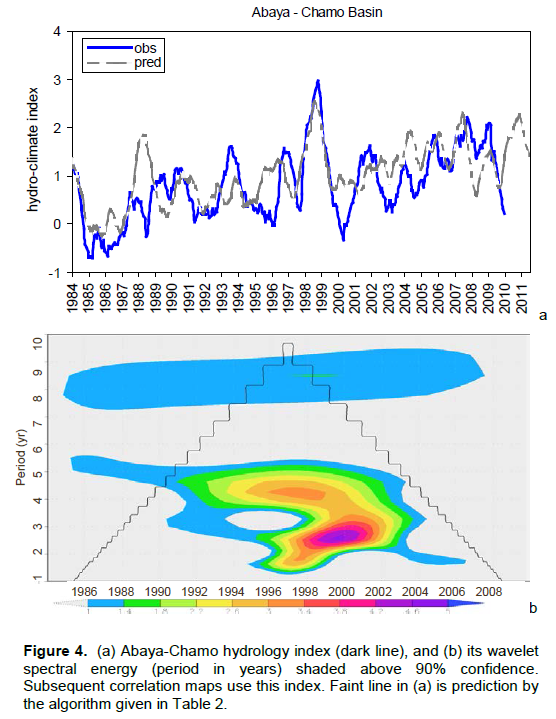
Ethiopia’s southern rift valley lakes of Abaya and Chamo (5.6-6.9°N, 37.3-38.3°E) are the focus of this study (Table 1). Their daily levels and discharge are monitored by the Ministry of Water Resources: Lake Abaya has three level-recording stations, while Lake Chamo has one. Flow discharge is measured at nine stations, and three have complete records: two downstream (south) of Abaya, and one south of Chamo. Studies by Schutt et al. (2002) and Goerner et al. (2009) indicate that Lake Abaya-Chamo has risen (1.37 m) in recent decades due to a combination of tectonic uplift and sediment accumulation at the southern outlet. Following quality checks, averaging of overlapping data and linear interpolation of short gaps, complete time series were reconstructed from 1983 to 2009 to study hydrological fluctuations. Daily values were subsequently averaged to monthly (N=312) for analysis of seasonal to interannual variability.
 
In-situ hydrological records were supplemented with NASA satellite altimetry and gravity measurements (Tapley et al., 2004; Cretaux et al., 2011; Velpuri et al., 2012); and GPCCv6  gauge interpolated rainfall observations (Schneider et al., 2013) in the Abaya-Chamo basin (5.6-6.9°N, 37.3-38.3°E, Figure 1a,b). Area-averaged latent heat flux (LHF) and run-off estimated from the Global Land Data Assimilation System NOAHv2 model are employed (Rodell et al., 2004). Supporting datasets include: MODIS surface temperatures and enhanced vegetation index (EVI) (Huete  et  al., 2002),   European Community reanalysis fields (ECMWF) (Dee et al., 2011), NCEP-Coupled Forecast System (CFS) reanalysis fields (Saha et al., 2010) and National Climate Data Center (NCDC) v3 surface temperature, (Smith et al., 2008).
 
Cross-correlation of lake level and flow discharge with meteorological variables (Figure 3c) determined that a 1 year lagged running sum of GPCC6 rainfall, NOAH2 LHF and run-off anomalies best represents the hydrology. Hence their standardized departures were averaged with the reconstructed lake level and integrated flow discharge (Figure 2a, b) to create a continuous index with minimal trend (Figure 4a). This time series correlates above 50% with SST in the West Indian Ocean and tropical East Pacific.
 
 
To understand global climate influences on Abaya-Chamo hydrology, cross-correlation maps were computed at 6-month lead time. Candidate predictors were identified from the maps (Table 2, Figure 5a-c) and a multi-variate regression was calculated following the methods of Eldaw et al. (2003). Wet and dry spells were identified using streamflow records (Figure 2a) and their climate forcing was studied, with a focus on links to the Indian Ocean.


 RESULTS

Basin characteristics
 
Ethiopia is blessed with ample water resources to due its mountainous topography and tropical latitude (Figure 1a). Yet in the Rift Valley, reduced orographic forcing of convection means that rainall averages ~ 50 mm/month (Figure 1b). The Abaya-Chamo basin’s mean satellite vegetation cover (EVI) and day-time surface temperature is illustrated in Figure 1c, d, while characteristics are listed in Table 1. The vegetation fraction varies from <0.2 in the northern valley where land surface temperatures exceed 35°C, to >0.6 in the cool (20°C) eastern mountains. The annual cycle (not shown) is warmest 40°C in early March and coolest 20°C in late July, with vegetation reaching a minimum 0.2 in early March and a maximum 0.4 in late June. Most years exhibit a uni-modal distribution. Lake surface temperatures are ~10°C cooler than the surrounding valley and consistent with nearby mountains, giving rise to local circulations and convective patterns embedded in a prevailing southeasterly wind (Figure 1b) with an upslope component.
 
Hydrology observations and annual cycle
 
The raw monthly in-situ records on flow discharge and lake level at various stations are given in Figure 2. Both exhibit trends characterized by low and stable values up to 1993; a marked upward trend with increasing spread to 1998, and high and relatively stable values thereafter. The background up-trend is related to geological shifts and sedimentation (Goerner et al., 2009). The intermittent flow discharge at various stations and different reference levels for the lake are evident. Bewketu (2010) reviews the issues of data quality and notes uptrends of inflow to Lake Abaya and a 10% contraction of Lake Chamo shoreline since 1986. Here the data gaps were overcome by first establishing a base level then averaging all stations to a single time series. Further gaps at the end of the record in 2008 to 2009 were filled using proportionately scaled NASA satellite altimetry / gravity measurements, (eg. fitting overlapping records and projecting values forward).
 
Lake level data for nearby Lake Victoria and Lake Turkana provide a long-term context for our observations (Figure 2c). There is a huge 2 m rise in 1961 caused by a flood event similar to that described in short-term events (Figure 6); followed by a slow decline to present. Floods punctuate the Lake Victoria record in 1977 to 1978 and 1997 to 1998, and droughts in 1992 to 1993 and 2005 to 2006. Hence the uptrend in our Abaya-Chamo series (+.05 m/year) is at odds with lake levels 200 km to the south (-.02 m/yearr since 1965), making it advisable to partially detrend the record as described earlier.
 
Intercomparisons of climate and hydrology observations are made for the annual cycle in Figure 3. The run-off and inflow is lowest in February and rise to a peak in May. Run-off stays above 0.7 mm/day from May to October then declines in the December to February dry season. The corresponding Lake Abaya-Chamo level (Figure 3a) is lowest in March and rises gradually to a peak by November. The lake level lags inflow from run-off, which in turn lags rainfall. Lake levels continually integrate the effects of climate, unlike inflows which reflect short-term events. The annual cycle of rainfall shows a major peak in April-May and a minor peak in September-October (Figure 3b). LHF remains high from April to November, while low values are found in December-February. Sensible heat flux (SHF), on the other hand, is greatest from Janurary to March and  is consistent
 
 
with latent heat flux the rest of the year. Precipitation exceeds evaporation only in April-May. Bewketu (2010) notes that Lake Abaya-Chamo level is better correlated with evaporation and run-off, than with local rainfall.
 
Hydrology response to climate
 
 
The hydrological response lag is determined by lag cross-correlation with monthly GPCC6 rainfall from 0-12 months. Observed lake level and outflow, and NOAH2 run-off all exhibit weak correlation at zero lag (Figure 3c). Hydrology variables cross-correlated with basin rainfall reach a plateau by 6-month lag and tail off gradually. Thus a 0-12 months lagged running sum (time integral) is considered optimal for merging meteorology variables (GPCC6 rainfall, NOAH2 LHF and run-off) with hydrology observations (lake inflow and level, Figure 2a,b). Together they form the Lake Abaya-Chamo index (Figure 4a). Its wavelet spectrum exhibits 2 to 5 years cycling with a weak harmonic at 8 to 9 years (Figure 4b). Subsequent analyses make use of this time-integrated index.     Field correlation maps at 6-month lead time with respect to the Abaya-Chamo index are given in Figure 5a,b, with values < 90% confidence masked. For NCDC3 (detrended) surface temperature, positive correlations w.r.t. lake levels are noted in the east Pacific, subtropical Atlantic and western Europe. There is also a region of positive correlation in the tropical Indian Ocean. ECMWF 850 hPa zonal winds exhibit noteworthy correlations in the equatorial Pacific (+ westerly) and Indian Oceans (– easterly). Extracting five key predictors as detailed in Table 2, cross-correlations with the Abaya-Chamo index exhibit a ‘crest’ at 6-9 month lead time (Figure 5c). In multi-variate tests, west Indian Ocean predictors drop out because their influence is confined to August-December, while east Pacific and Atlantic predictors have continuous influence. After step-wise multi-variate regression, the predictive algorithm (Table 2, Figure 4d) achieves a 44% fit, with all inputs positive and


the subtropical Atlantic surface temperature having largest coefficient. The algorithm follows the uptrend but over-predicts neutral cases. It forecasts 2 to 5 fluctuations and the 1997 to 1999 oscillation, but is too dry in 1993, 2008, and too wet in 1988, 2000. Thus Lake Abaya-Chamo rises during Pacific El Niño when the Indian Ocean dipole is active (Figure 5a,b). The 44% r2 fit is statistically significant at 99% confidence, after deflating the degrees of freedom for target autocorrelation. The relationship between ENSO and the Indian Ocean dipole has been described by (Saji et al., 1999; Xie et al., 2001; Luo et al., 2010; Izumo et al., 2010). This feature is analogous to the thermocline see-saw of the Pacific, and is related to a sub-tropical ocean Rossby wave coupled with equatorial zonal winds (Jury and Huang, 2004; Jury, 2013). As the thermocline deepens in the west Indian Ocean with an incoming Rossby wave, SSTs increase z +1C and contribute to heavy rains over East Africa particularly after August (Behera et al., 2005; Yeshanew and Jury, 2007). The first event described below is one of those cases.
 
 
Short-term events
 
Events in the daily record of flow discharge are analyzed in this section, and two cases are selected for detailed study. The first case is the flood event of October to December 1997 (Figure 6) which has been well studied (Birkett et al., 1999; Goddard and Graham 1999; Mercier et al., 2002). Hydrological records indicate that Kulfo discharge reached 462 m3/s on 30 October, Lake Chamo rose 0.08 m on 20 November and Woito discharge set a record of 854 m3/s on 27 November  1997.  A  number  of pulses are seen in the time series (Figure 6a) which can be traced to westward moving convective waves arriving from the Indian Ocean (Morel et al., 2011). The rainfall distribution (Figure 6b) exhibited a narrow N-S wet zone along 38E from Mombasa to Arba Minch. Winds over the Indian Ocean reflect a zonal overturning Walker circulation anomaly (Figure 6c) with rising motion over the algorithm yields time series (Figure4a) and scatterplot (Figure 5d).
 
 
Ethiopia and descending motion west of Indonesia. Sea surface temperature anomalies were > +1.5°C off Somalia and cool off Sumatra (Figure 6d), and easterly winds connected the two centers of action: the Indian Ocean dipole. This pattern was repeated in 1961 and 1977, adding > 1 m to Lake Victoria (Figure 2c).
 
Dry spells that diminish lake levels are related to high evaporation rates during heat waves. In Figure 7a the Kulfo discharge from Abaya to Chamo nearly stopped (< 2 m3/s) from 16-22 March 2000 coincidently with basin-averaged maximum temperatures > 30°C. Lake Abaya- Chamo level dropped from 2.72 m in November 1999 to0.93 m by April 2001. The widespread nature of the March 2000 drought is evident in MODIS day-time land surface temperatures > 40°C across Sudan, Ethiopia, Kenya and Somalia (Figure 7b). Satellite out-going longwave radation (OLR) anomalies > +20 W/m2 formed an axis through southern Ethiopia in March 2000 (Figure 7d), while negative anomalies were evident south of the equator over Tanzania. A feature of this drought was the Hadley overturning circulation (Figure 7c), exhibiting sinking motions and northerly winds over Ethiopia (Figure 7d). The inter-tropical convergence zone remained south of its usual position (green shaded humidity, Figure 7c) and thus early season rains failed. Coincidently, southern Africa experienced epic flooding (Jury and Lucio, 2004).


 CONCLUSIONS

This study has described hydrological fluctuations of Lake Abaya-Chamo and its climate and weather forcing. While earlier studies found weak correlation between lake level and rainfall (Belete, 2009), here consideration of the hydrological response lag yielded close relationships using time-integrated anomalies. The findings are summarized in the following points:
 
(i) Direct measurements of large lakes are valuable as they integrate the effects of climate in space and time.
(ii) Satellite and model interpolated data follow the hydrological record when summed over the preceding 12 months, especially GPCC6 rainfall, NOAH2 LHF and run-off, and ECMWF climate fields.
(iii) The Pacific ENSO and subtropical Atlantic affects continuous flow discharge, while the Indian Ocean dipole has influence after August. A predictive algorithm accounts for 44% of variance at 6 month lead time.
(iv) The Abaya-Chamo basin is on the edge of the East Africa climate regime shared with Kenya, wherein higher lake level coincides with a maturing El Niño.
(v) Early season dry spells prevail when the equatorial trough remains over Tanzania, and the Hadley cell brings dry northerly winds that accelerate evaporation: March 2000.
 
(vi) Late season floods are related to easterly winds and a down-tilted thermocline (Jury and Huang, 2004, Yeshanew and Jury, 2007) that comprise the Indian Ocean dipole. In response, lake levels can rise 1m/month: October 1961, 1977, 1997.
 
Further research progress will depend on ready access to daily flow data, sustained local measurements timeously reported to international data centers, the calibration and operational use of mesoscale weather forecast models, and the maintenance of multi-disciplinary regional science networks. Although predictability was uncovered for Lake Abaya-Chamo, more than half of the fluctuations are unresolved. Thus coping mechanisms and strategies for resource switching in wet and dry years is needed, to keep the growing rural population on a sustainable socio-economic path.


 CONFLICT OF INTEREST

The authors have not declared any conflict of interest.


 ACKNOWLEDGEMENTS

The author thanks Gosa Damtew of Arba Minch University, Ethiopia for provision of in-situ Abaya-Chamo Lake level and flow data. Satellite data and model interpolated reanalyses were studied in the following websites: Climate Explorer, IRI Climate Library, NASA-Giovanni, JPL-Grace and USDA-altimetry. This study contributes to the Rockefeller Project on Climate Vulnerability with  the  Ethiopian  Institute  for  Agriculture Research, Melkasa.


 REFERENCES


Awulachew SB (2001). Investigation of water resources aimed at multi- objective development with respect to limited data situation: The case of the Abaya-Chamo basin, Ethiopia. PhD Thesis, Tech. Univ.Dresden.


Awulachew SB (2006). Investigation of physical and bathymetric characteristics of Lakes Abaya and Chamo, Ethiopia, and their management implications, Lake Res. Res. Man. 11:133-140.
Crossref


Ayenew T (2002). Recent changes in the level of Lake Abiyata, central main Ethiopian Rift. Hydrol. Sci. J. 47:493-503.
Crossref


Ayenew T, Becht R (2007). Comparative study of the hydrology and hydrogeology of selected Ethio-Kenyan- rift lakes. Catch. Lake Res. LARS, pp. 144-147.


Ayenew T (2009). Natural Lakes of Ethiopia. Addis Ababa University Press. Addis Ababa, Ethiopia, 206 pages.


Behera SK, Luo JJ, Masson S, Delecluse P, Gualdi S, Navarra A, Yamagata T (2005). Paramount impact of the Indian Ocean dipole on the East African short rains: a CGCM study. J. Climate 18:4514-4530.
Crossref


Belete A (2009). Climate Change impacts on Lake Abaya water level, MSc thesis, Addis Ababa Univ. P. 134.


Bewketu K (2010). Hydrodynamics of selected Ethiopian Rift Lakes, MSc thesis, Addis Ababa Univ, P. 80.


Birkett CM, Murtugudde R, Allan T (1999). Indian Ocean climate event brings floods to east Africa's lakes and the Sudd Marsh. Geophys. Res. Lett. 26:1223-1234.
Crossref


Camberlin P (1997). Rainfall anomalies in the source region of the Nile and their connection with Indian summer monsoon. J. Climate 10:1380-1392.
Crossref


Camberlin P, Janicot S, Poccard I (2001). Seasonality and atmospheric dynamics of the teleconnection between African rainfall and tropical sea surface temperature: Atlantic vs. ENSO, Int. J. Climatol. 21:973-1005.
Crossref


Cretaux JF, Jelinskia W, Calmantb S, Kouraevc A, Vuglinskid V, Bergé-Nguyena M, Genneroa M-C, Ninob F, Abarca Del Rioe R, Cazenavea A, Maisongrande P (2011). A Lake database to monitor in Near Real Time water level and storage variations from remote sensing data. J. Adv. Space Res., doi:10.1016/j.asr.2011.01.004
Crossref


Dee DP, Uppala SM, Simmons AJ, Berrisford P, Poli P, Kobayashi S, Andrae U, Balmaseda MA, Balsamo G, Bauer P, Bechtold P, Beljaars ACM, van de Berg L, Bidlot J, Bormann N, Delsol C, Dragani R, Fuentes M, Geer AJ, Haimberger L, Healy SB, Hersbach H, Hólm EV, Isaksen L, Kållberg P, Köhler M, Matricardi M, McNally AP, Monge-Sanz BM, Morcrette J-J, Park B-K, Peubey C, de Rosnay P, Tavolato C, Thépaut J-N, Vitart F (2011). The ERA-Interim reanalysis: configuration and performance of the data assimilation system. Q. J. Royal Met. Soc. 137:553-597.
Crossref


Dettinger MD, Diaz HF (2000). Global characteristics of stream flow seasonality and variability. J. Hydromet. 1:289-310.
Crossref


Eldaw AK, Salas JD, Garcia LA (2003). Long-range forecasting of the Nile River flows using climatic forcing. J. Appl. Meteor. 42:890-904.
Crossref


Gebremariam B (2007). Basin scale sedimentary and water quality responses to external forcing in Lake Abaya, southern Ethiopian Rift Valley, PhD Thesis, Freie Universität Berlin, P. 157.


Goddard L, Graham NE (1999). Importance of the Indian Ocean for stimulation rainfall anomalies over eastern and southern Africa. J. Geophys. Res. 104:D16:19099-19116.
Crossref


Goerner A, Jolie E, Gloaguen R (2009). Non-climatic growth of the saline Lake Beseka, Main Ethiopian Rift, J. Arid Environ. 3:287-295.
Crossref


Huete A, Didan K, Miura T, Rodriguez EP, Gao X, Ferreira LG (2002). Overview of the radiometric and biophysical performance of the MODIS vegetation indices. Rem. Sens. Environ. 83:195-213.
Crossref


Izumo T, Vialard J, Lengaigne M, de Boyer Montégut C, Behera SK, Luo JJ, Cravatte S, Masson S, Yamagata T (2010). Influence of the state of the Indian Ocean Dipole on following year's El Ni-o, Nature Geosci. 3:168-172.
Crossref


Jury MR, Huang B (2004). The Rossby wave as a key mechanism of Indian Ocean climate variability, Deep Sea Res. 51:2123-2136.
Crossref


Jury MR, Lucio FD (2004). The Mozambique floods of February 2000 in context, SA Geogr. J. 86:141-146.
Crossref


Jury MR (2011). Climatic factors modulating Nile River flow, in Nile River Basin part 4, ed. A.M. Melesse, Springer. pp. 267-280.
Crossref


Jury MR (2013). Variability in the tropical southwest Indian Ocean and influence on southern Africa climate, Int. J. Mar. Sci. 3:46-64.


Luo J-J, Zhang R, Behera SK, Masumoto Y, Jin F-F, Lukas R, Yamagata T (2010). Interaction between El Ni-o and extreme Indian Ocean dipole. J. Climate 23:726-742.
Crossref


Mercier F, Cazenave A, Maheu C (2002). Interannual lake level fluctuations in Africa from Topex/Poseidon: connections with ocean-atmosphere interactions over the Indian Ocean. Global Planetary Chg. 32:141-163.
Crossref


Morel B, Bessafi M, Babu A, Chang L, Kabengel H, Mwangi S (2011). Analysis of the 1997 floods over East Africa, THORPEX-enhans presentation, Pretoria, P. 45.


Potter C, Zhang P, Klooster S, Genovese V, Shekhar S, Kumar V (2004). Understanding controls on historical river discharge in the world's largest drainage basins. Earth Int. 8:1-21.
Crossref


Quinn WH (1992). A study of southern oscillation-related climate activity 622-1990 incorporating Nile River flow data. in 'El Nino: Historical and paleoclimate aspects of Southern Oscillation' ed. Diaz H F and Markgraf V, Springer, pp. 119-142.


Rodell M, Houser PR, Jambor U, Gottschalck J, Mitchell K, Meng C-J, Arsenault K, Cosgrove B, Radakovich J, Bosilovich M, Entin JK, Walker JP, Lohmann D, Toll D (2004). The Global Land Data Assimilation System, Bull. Amer. Meteor. Soc. 85:381-394.
Crossref


Roskar J (2000). Assessing the water resources potential of the Nile River based on data at the Nile forecasting center Cairo, Geographical J. Slovakia, pp. 31-80.


Saha S, and co-authors Shrinivas M, Hua-Lu P, Xingren W, Jiande W, Sudhir N, Patrick T, Robert K, John W, David B, Haixia L, Diane S, Robert G, George G, Jun W, Yu-Tai H, Hui-Ya C, Hann-Ming HJ, Joe S, Mark I, Russ T, Daryl K, Paul Van D, Dennis K, John D, Michael E, Jesse M, Helin W, Rongqian Y, Stephen L, Huug Van DD, Arun K, Wanqiu W, Craig L, Muthuvel C, Yan X, Boyin H, Jae-Kyung S, Wesley E, Roger L, Pingping X, Mingyue C, Shuntai Z, Wayne H, Cheng-Zhi Z, Quanhua L, Yong C, Yong H, Lidia C, Richard WR, Glenn R, Mitch G (2010). The NCEP Climate Forecast System Reanalysis, Bull. Amer. Me-teor. Soc. 91:1015-1057.


Saji N H, Goswami BN, Vinayachandran PN, Yamagata T (1999). A dipole mode in the tropical Indian Ocean. Nature 401:360-363.
Crossref


Schneider U, Becker A, Finger P, Meyer-Christoffer A, Ziese M, Rudolf B (2013). GPCC's new land surface precipitation climatology based on quality-controlled in situ data and its role in quanti-fying the global water cycle, Theor. Appl. Climatol. doi10.1007/s00704-013-0860-x
Crossref


Schutt B, Förch G, Bekele S, Thiemann S, Wenclawiak B (2002). Modern water level and sediment accumulation changes of Lake Abaya, southern Ethiopia, in: G.H. Schmitz (ed.), Water Res. Environ. Res. 2:418-422.


Schutt B, Thiemann S (2004). Modern water lever and sediment accumulation changes of Lake Abaya, southern Ethiopia – A case study from the Bilate River delta, Sust. Man. H. Res. 137-154.


Schutt B, Thiemann S (2006). Kulfo River, south Ethiopia as a regulator of lake level changes in the Lake Abaya-Lake Chamo System, Zbl. Geol. Paläont. 1:129-143.


Segele ZT, Lamb PJ, Leslie LM (2009). Seasonal-to-interannual variability of Ethiopia/ Horn of Africa monsoon, Part I: Associations of wavelet-filtered large-scale atmospheric circulation and global sea surface temperature, J. Climate 22:3396-3421.
Crossref


Seleshi Y (1991). Statistical analysis of Ethiopian droughts in the 20th century based on monthly and yearly precipitation totals. MSc. thesis, Vrije Univ., Brussels, Belgium.


Servat E, Hughes D, Fritsch J-M, Hulme M (1998). Water Resources Variability in Africa during the 20th Century. Proc. Abidjan Conf. IAHS Publ. P. 252.


Smith TM, Richard WR, Thomas CP, Jay L (2008). Improvements to NOAA's historical merged land-ocean surface temperature analysis 1880-2006, J. Climate 21:2283–2293.
Crossref


Tapley BD, Bettadpur S, Watkins M, Reigber C (2004). The gravity recovery and climate experiment: Mission overview and early results, Geophys. Res. Lett. 31:L09607.
Crossref


Velpuri NM, Senay GB, Asante KO (2012). A multi-source satellite data approach for modelling Lake Turkana water level: calibration and validation using satellite altimetry data, Hydrol. Earth Syst. Sci. 16:1-18.
Crossref


Yeshanew A, Jury MR (2007). North African climate variability, part 2: Tropical circulation systems, Theor Appl. Climatol. 89:37-49.
Crossref


Zeng N, Eltahir EAB (1998). The role of vegetation in the dynamics of West African monsoons, J. Climate. 11:2078-2096.
Crossref


Zeng N, Neelin JD, Lau KM, Tucker CJ (1999). Enhancement of interdecadal climate variability in the Sahel by vegetation interaction, Sci. 286:1537-1540.
Crossref


          */?>