Full Length Research Paper

ABSTRACT
INTRODUCTION

DATAS AND METHODS
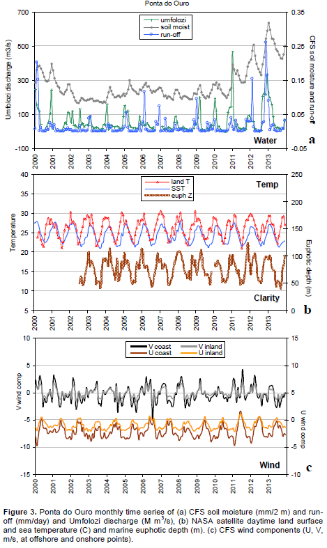
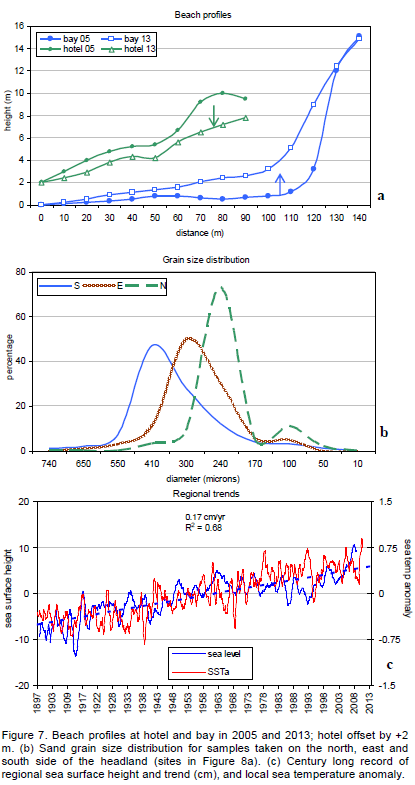
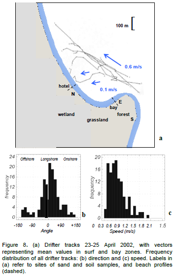
RESULTS


SUMMARY
ACKNOWLEDGEMENTS
CONFLICT OF INTEREST
REFERENCES
| Australia, Proc. Oceans 2003 symposium, San Diego, USA. | ||||
|
Bassoullet P, Hir PL, Gouleau D, Robert S (2000). Sediment transport over an intertidal mudflat: field investigations and estimation of fluxes within the Baie de Marennes-Oleron (France). Cont. Shelf Res. 20:1635-1653. Crossref |
||||
| Benumof BT, Storlazzi CD, Seymour RJ, Griggs GB (2000). The relationship between incident wave energy and seacliff erosion rates: San Diego County, California. J. Coast Res. 16:162-1172. | ||||
| Bjerner M, Johansson J (2001). Economic and environmental impacts of Nnture based tourism: A case study of Ponta do Ouro, Mozambique, Univ Edwardo Mondlane Technical Report. | ||||
| Carter RWG (1988). Coastal Environments: An Introduction to the Physical, Ecological and Cultural Systems of Coastlines. Academic Press, London UK, pp. 213-217. | ||||
| Carter RWG, Jennings SC, Orford JD (1990). Headland erosion by waves. J. Coast Res. 6:517-529. | ||||
| Chandrasekar N, Anil C, Rajamanickam M, Rajamanickam GV (2000). Coastal landform mapping between Tuticorin and Vaippar using IRS-1C data. Indian J. Geomorphol. 5:114-120. | ||||
|
Chassignet EP, Hurlburt HE, Metzger EJ, Smedstad OM, Cummings JA, Halliwell GR, Bleck R, Baraille R, Wallcraft AJ, Lozano C, Tolman HL, Srinivasan A, Hankin S, Cornillon P, Weisberg R, Barth A, He R, Werner F, Wilkin J (2009). US GODAE: Global ocean prediction with the Hybrid coordinate ocean model (Hycom). Oceanography 22:64-75. Crossref |
||||
|
Chauhan P, Nayak S, Ramesh R, Krishnamoorthy R, Ramachandran S (1996) Remote sensing of suspended sediments along the Tamil Nadu coastal waters. J. Ind. Soc. Remote Sens 24:105-114. Crossref |
||||
| Christie MC, Dyer KR (1998). Measurements of the turbid tidal edge over the Skeffling mudflats. in: Black KS, et al. (eds) Sedimentary processes in the intertidal zone. Geol. Soc. London Spec. Publ. 139:45-55. | ||||
| Corbello S, Stretch DD (2012a). The wave climate on the KwaZulu-Natal coast of South Africa. J. South Afr. Instit. Civ. Eng. 54:45-54. | ||||
|
Corbello S, Stretch DD (2012b). Decadal trends in beach morphology on the east coast of South Africa and likely causative factors, Nat. Hazards Earth Syst. Sci. 12:2515-2527. Crossref |
||||
|
Esteves LS, Williams JJ, Lisniowski MA (2009). Measuring and modelling longshore sediment transport, Estu. Coast. Shelf Sci. 83:47-59. Crossref |
||||
| Faria M, Almedia S (1996). Plano de Desenvolvimento e Gestão dos Recursos Naturais do Distrito de Matutíne, Maputo. | ||||
|
Frihy OE, Lotfy MF (1997). Shoreline changes and beach-sand sorting along the northern Sinai coast of Egypt. Geo-Mar Lett. 17:140-146. Crossref |
||||
| Ganesh R, Gopaul N (2013). A Predictive Outlook of Coastal Erosion on a Log-Spiral Bay (Trinidad) by Wave and Sediment Transport Modelling, in: Conley, D.C., et al. (eds.), Proc 12th Intl Coastal Symp (Plymouth), J. Coastal Res. 65:488-493. | ||||
|
Georgiou IY, Schindler JK (2009). Wave forecasting and longshore sediment transport gradients along a transgressive barrier island: Chandeleur Islands, Louisiana. Geo-Mar Lett. 29:467-476. Crossref |
||||
| Goschen WS, Schumann EH (2011). The physical oceanographic processes of Algoa Bay, SAEON-IMT report, P0106-110000-730002. | ||||
|
Joyce RJ, Janowiak JE, Arkin PA, Xie PP (2004). CMORPH: A method that produces global precipitation estimates from passive microwave and infrared data at high spatial and temporal resolution. J. Hydrometeorol. 5:487-503. Crossref |
||||
| Jury MR, Cuamba P, Rubuluza P (2011b). Development strategies for a coastal resort in southern Mozambique. Afr. J. Bus. Manage. 5(2):481-504. | ||||
|
Kaczmarek LM, Ostrowski R, Pruszak Z, Rozynski G (2005) Selected problems of sediment transport and morphodynamics of a multi-bar nearshore zone. Estu. Coast. Shelf Sci. 62:415-425. Crossref |
||||
| Kaliraj S, Chandrasekar N, Magesh NS (2013). Impacts of wave energy and littoral currents on shoreline erosion/accretion along the south-west coast of Kanyakumari, Tamil Nadu using DSAS geospatial technology. Environ Earth Sci. doi10.1007/ s12665-013-2845-6. | ||||
| Lacey EM, Peck JA (1998). Long-term beach profile variations along the south shore of Rhode Island, USA. J. Coast Res. 14:1255-1264. | ||||
|
Lee HJ, Jo HR, Chu YS, Bahk KS (2004) Sediment transport on macrotidal flats in Garolim Bay, west coast of Korea: significance of wind waves and asymmetry of tidal currents. Cont. Shelf Res. 24:821-832. Crossref |
||||
|
Maktav D, Erbek FS, Kabdasli S (2002). Monitoring coastal erosion at the black sea coasts in turkey using satellite data: A case study at the lake Terkos, north-west Istanbul. Int. J. Remote Sens. 23:4115-4124. Crossref |
||||
|
Manson GK, Solomon SM, Forbes DL, Atkinson DE, Craymer M (2005). Spatial variability of factors influencing coastal change in the Western Canadian Arctic. Geo-Mar Lett. 25:138-145. Crossref |
||||
|
Miller HC (1999). Field measurements of longshore sediment transport during storms, Coastal Eng. 36:301-321. Crossref |
||||
|
Perry C (2003). Reef Development at Inhaca Island, Mozambique. Ambio 32:134-139. Crossref |
||||
| Psuty N (1992). Spatial variation in coastal foredune development, in R. Carter, et al. (ed.), Coastal Dunes: Geomorphology, Ecology and Management for Conservation. Hague, Balkema, pp. 3-13. | ||||
|
Ridderinkhof H, van der Hama R, van der Lee W (2000). Temporal variations in concentration and transport of suspended sediments in a channel-flat system in the Ems-Dollard estuary. Cont. Shelf Res. 20:1479-1493. Crossref |
||||
|
Saha S, Saha S, Shrinivas M, Hua-Lu P, Xingren W, Jiande W, Sudhir N, Patrick T, Robert K, John W, David B, Haixia L, Diane S, Robert G, George G, Jun W, Yu-Tai H, Hui-Ya C, Hann-Ming HJ, Joe S, Mark I, Russ T, Daryl K, Paul Van D, Dennis K, John D, Michael E, Jesse M, Helin W, Rongqian Y, Stephen L, Huug Van Den D, Arun K, Wanqiu W, Craig L, Muthuvel C, Yan X, Boyin H, Jae-Kyung S, Wesley E, Roger L, Pingping X, Mingyue C, Shuntai Z, Wayne H, Cheng-Zhi Z, Quanhua L, Yong C, Yong H, Lidia C, Richard WR, Glenn R, Mitch G (2010). The NCEP Climate Forecast System Reanalysis. Bull. Am. Meteor. Soc. 91:1015-1057. Crossref |
||||
|
Saravanan S, Chandrasekar N, Sheik Mujabar P, Hentry C (2011). An overview of beach morphodynamic classification along the beaches between Ovari and Kanyakumari, Southern Tamil Nadu coast, India. Phys. Oceanogr. 21:130-141. Crossref |
||||
| Silvester R (1984). Ecological effects of various coastal defence systems. J. Water Science & Technology, 16(3-4):355-365. | ||||
| Silvester R, Hsu JRC (1993). Coastal Stabilization. Prentice Hall, NJ. 578 p. | ||||
|
Smith AM, Guastella LA, Botes ZA, Bundy SC and Mather AA (2014). Forecasting cyclic coastal erosion on a multi-annual to multi-decadal scale: Southeast African coast, Estu. Coast. Shelf Sci., doi10.1016/j.ecss.2013.12.010. Crossref |
||||
|
Sterl A, Caires S (2005). Climatology, variability and extrema of ocean waves - The Web-based KNMI/ERA-40 Wave Atlas. Int. J. Climatol. 25:963-977. Crossref |
||||
| Tinley K (1985). Coastal dunes of Southern Africa, Foundation for Research and Development, South Africa. | ||||
| Trenhaile AS (1997). Coastal dynamics and landforms. Clarendon, Oxford, 366 pages. | ||||
|
VanRijn LC (2009). Prediction of dune erosion due to storms, Coastal Eng. 56:441-457. Crossref |
||||
|
VanWellen E, Chadwick AJ, Mason T (2000). A review and assessment of longshore sediment transport equations for coarse-grained beaches. Coastal Eng. 40:243-275. Crossref |
||||
|
Wright LD, Short AD (1984) Morphodynamic variability of surf zones and beaches: A synthesis. Marine Geol. 50:93-118. Crossref |
||||
Copyright © 2024 Author(s) retain the copyright of this article.
This article is published under the terms of the Creative Commons Attribution License 4.0


