Full Length Research Paper

ABSTRACT
Assessment of land suitability for irrigation purpose is important to utilize limited resources efficiently and for the sustainable production of crops and food security of the ever increasing people in our country especially the study area. The existing small scale irrigation system in the Guangua Badiya river basin farming area has no adequate soil and land resource information and also the irrigated area is very small. Thus irrigation land suitability assessment plays an imperative role for sustainable utilization of scarce physical land resources. This study was initiated with the objective of assessing land suitability evaluation for agriculture under irrigation of the River Guangua Badiya in Abaya District of Borena Zone, Oromiya Region, Ethiopia. Watershed delineation, assessment of soil and slope parameters were the steps followed to evaluate land suitability for irrigated agriculture. To identify land suitability for irrigation purpose, the following factors such as soil type, slope, and distance from water supply (sources) were taken into account. Soil sampling spots were selected based on free and grid survey techniques and their locations were taken using Global Positioning System (GPS). Soil samples were collected and used for suitability assessment. Soil samples used as criteria for irrigation suitability analysis were pH, texture, soil depth, EC, ESP, top and sub soil stoniness. Slope suitability map of the study area was derived from digital elevation model of the area clipped from SRTM of NASA satellite with 30 m resolution by masking layer of sub catchment. Qualitative evaluation was carried out with the help of FAO land evaluation method. Result of suitability of land evaluation ratings based on the qualitative land suitability for irrigation indicated that, 9.32% (1303 ha) are highly suitable (S1), 32.5% (4558 ha) are moderately suitable (S2), 23.82% (3335 ha) marginally suitable (S3) and 34.30 (4802 ha) are not suitable (N) for surface irrigation systems. Hence, the majority of the study areas are in a range value of highly to marginally suitable for surface irrigation purpose. Due to high slope range value 4802 ha of lands are non-suitable for irrigation purpose.
Key words: Suitability, irrigation, soil properties, Guangua Badiya river.
INTRODUCTION
Background
Ethiopia is an agrarian country on which agriculture provides 47% of the gross domestic product (GDP), 80% of the employment and 60% of the export commodity (World Bank, 2011). The country depends on the rain fed agriculture with limited use of irrigation for agricultural production. It is estimated that more than 90% of the food supply in the country comes from low productivity rain-fed smallholder agriculture and hence rainfall is the single most important determinant of food supply (FDRE, 2011). Considering the fact that, production system is dominated by small-scale subsistence farming system largely based on low-input and low-output rain-fed agriculture. As the result farm output lags behind the food requirement of the fast growing population. The high dependency on rain-fed farming and erratic rainfall require alternative ways of improving agricultural production.
The need to double food production over the next two decades, water has been recognized as the most important factor for the transformation of low productive rain-fed agriculture into most effective and efficient irrigated agriculture (FAO, 1996). It is obvious that the utilization of water resources in irrigated agriculture provide supplementary and full season irrigation to overcome the effects of rainfall variability and unreliability. Hence, the solution for food insecurity could be provided by irrigation development that can lead to security by reducing variation in harvest, as well as intensification of cropping by producing more than one crop per year.
Ethiopia has immense potential in expanding irrigated agriculture. Despite its irrigation potential which is estimated to be about 3.7 million hectare, only about 190,000 ha (5.3% of the potential) is currently under irrigation, which plays insignificant role in the country’s agricultural production (Negash and Seleshi, 2004). Use of land and water resources for the development of irrigation facilities could lead to substantial increase in food production in many parts of the world. Proper use of land depends on the suitability or capability of land for specific purposes (Fasina et al., 2008).
Thus, to bring food security at national as well as household level, improvement and expansion of irrigated agriculture must be seriously considered.
In developing supplementary irrigation, evaluating and assessing of the potential and suitability of the land area will provide a comprehensive and integrated economic viability and sustainability of water resource development. However, in Ethiopia, particularly in the study area this is almost ignored and any type of irrigation is practiced without proper investigation on the potential of the area for irrigation purpose. To reduce the human influence on natural resources and to identify an appropriate land use, it is essential to carry out scientific land evaluations. Such kind of analysis allows identifying the main limiting factors for the agricultural production and enables decision makers to develop crop managements able to increase the land productivity. Therefore, the main target of this study was to determine the land suitability of the study area for irrigation purpose.
MATERIALS AND METHODS
Description of the study area
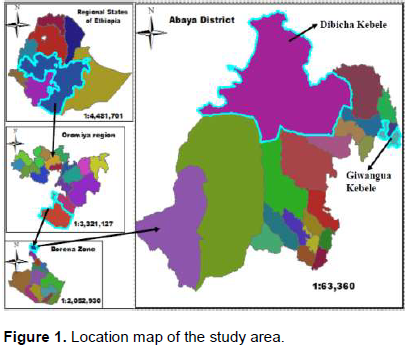
The study was carried out in Guangabadiya sub catchment, in Abaya district (Figure 1). It is found in Oromia regional state (06°11' 56"- 06°25'06"Latitude and 38°06'00"Longitude). The area is located at about 430 km east of Addis Ababa. It has bimodal rain fall pattern, with annual average rain fall of 700 to 1200 mm; daily mean temperature ranges 27°C. The dominant soil type in the area is clay soil and the soils within the command area have deep effective soil depth The district has a total areas of 187134 ha of land, out of which, 60728 ha cultivated land, 45275 ha grazing land, 12404 ha forest and bush land, 62925 ha covered by Lake Abaya, and 5801 ha allotted for other activities. Abaya district has a potential of more than twelve perennial rivers include the Gelana and Gidabo and also in the area both traditional and modern irrigation systems are practiced. The area with heavily deforested, and the remaining vegetation is predominantly scattered bush, and acacia trees. The major crops grown in the area are: Maize, teff, haricot bean, groundnut, tomato, onion, potato, pepper, cabbage, coffee and enset (Abaya Woreda Agricultural Office Report, 2014).
Method of data collection
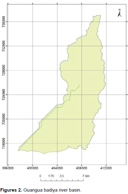
Watershed delineation: Watershed delineation was done using ArcSWAT 10 which is imbedded in ArcGIS 10. The watershed delineation showed that the Guangua Badiya river basin covers a total area of 13,998 ha (Figure 2).
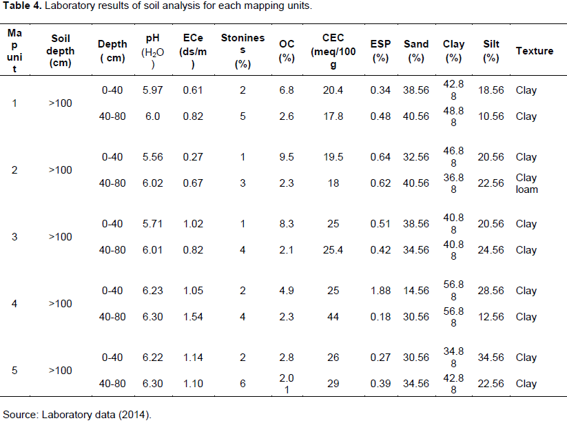
Soil and slope data: Based on a preliminary soil survey, soil samples were collected from five profile and ten auger holes .The sampling points were selected using free survey techniques. Being a medium intensity soil survey one observation per 50 ha was taken as per the recommendations of (FAO, 1979). Observation sites were located according to the requirements and complexity of the soil patterns and composite soil samples were used for soil analysis. The internal properties of the soil were described by using profile pits. Profile explorations were made at five suitable sites based on drainage property of the specific location and relative position in the slope of the study area described by using soil description guideline (FAO, 1990). In characterizing the topsoil and subsoil, five profile and ten auger holes (sampling points) were collected at 0-40 and 40-80 cm depth and their geographic location recorded using hand held GPS. The main focus of the study was on existing cultivated lands. The land evaluation was determined based upon topography and soil characteristics. The topography characteristics included slope while the soil samples were analyzed for top soil texture, stoniness soil properties, salinity, pH, cation exchange capacity (CEC), exchangeable sodium percentage (ESP) organic matter (%OM) and pH were considered (Sys et al., 1991). Land slope is the most important topographical factor influencing land suitability for irrigation. To derive slope suitability map of the study area, digital elevation model of the area was clipped from SRTM of NASA satellite with 30 m resolution by masking layer of Woreda boundary.
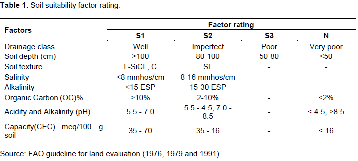
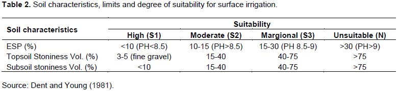
Suitability assessment method: The FAO (1976) frame work of suitability classes was commonly used (d’Angelo et al., 2000; Ahmed et al., 2000). As such, this frame work utilized as a basis for this analysis, with further adaptation from method described in Dent and Young (1981). The land suitability evaluation was determined based upon topography and soil characteristics. Thus to determine land suitability for irrigation purpose, these soil characteristics were matched with the interpretation ratings for soil chemical characteristics (Tables 1 and 2) (FAO, 1976).
Data analysis
In watershed delineation, the Digital Elevation Model (DEM) with 30 m pixel was used. GIS uses DEMs data as input digital elevation model of the area was clipped from SRTM of NASA satellite with 30 meters resolution. DEM was provided good terrain representation from which watersheds could be derived automatically using GIS technology. The techniques for automated watershed delineation were implemented in various GIS systems and custom applications (Garbrecht and Martz, 1999). Land unit map was used as a guide in the field survey, soil sampling and, in turn, developing a more detailed soil analysis. The soil samples collected from the selected sites were air dried and ground to pass through a 2 mm size sieve in preparation for the analysis of all soil properties. Finally, the collected soil samples were analyzed for selected soil properties at the Hawassa Regional Soil Laboratory following the standard analytical procedures.
Soil analysis and data interpretation
The soil samples collected were air-dried, gently crushed using a mortar and pestle, and passed through a 2 mm-sieve to obtain fine earth separates. The processed soil samples were analyzed for some physical and chemical properties following the procedures outlined by FAO (1976) as briefly highlighted herein. Particle size analysis was determined by the Bouyocous hydrometer method as described by Gupta (2004). Stoniness was assessed by sieving. Soil pH H2O suspension was determined with pH meter. The electrical conductivity (EC) of soils was measured from a soil water ratio of 1:2.5 socked for one hour by electrical conductivity method as described by Sahlemdhin and Taye (2000). The Walkley and Black (1934) wet digestion method was used to determine soil carbon content and percent soil OM was obtained by multiplying percent soil OC by a factor of 1.724 following the assumptions that OM is composed of 58% carbon. Exchangeable sodium percentage (ESP) was determined after analyzing sodium concentration and cations exchange capacity of the soil (% ESP = {Exch Na+}*100/CEC). Sodium concentration was determined using flame photometer; while CEC measurement was made by ammonium acetate method. The exchangeable sodium percentage was calculated, by dividing exchangeable sodium to cation exchange capacity.
Slope suitability analysis
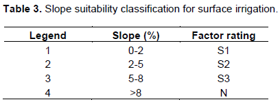
Land slope is the most important topographical factor influencing land suitability for irrigation. To derive slope suitability map of the study area, digital elevation model of the area was clipped from SRTM of NASA satellite with 30 m resolution by masking layer of Guangua Badiya river basin. Then slope map of sub catchment was derived using the “Spatial Analysis Slope” tool in ArcGIS. The Slope derived from the DEM was classified based on the classification system of FAO (1996) using the “Reclassification” tool, which is an attribute generalization technique in ArcGIS. The four suitability ranges S1, S2, S3 and N were classified for surface irrigation as shown in Table 3.
RESULT AND DISCUSSION
Physical land characteristics of the Guangua badiya sub basin for crops suitability
Soil depth, texture and stoniness
The soil depth of sub catchment as it was seen from auger-hole observation and profile description of soils, the soil depths at all sampling points were greater than 100 cm.
Thus the soil in the study area could be considered as deep soil. In all of mapping unit the surface and sub surface soil were dominated by clay. The maximum percentage of clay in the surface soil was observed as 100 percent on all mapping units, and the minimum percentage of clay was recorded as 80% in the sub-soil on mapping unit 2. No rock out crop was observed in the study area; however, there was a negligible coarse fragment.
As shown in Table 4, all mapping units showed that top soil stoniness and sub-soil stoniness were less than 3 and 10%, respectively. There was no significant variation of stoniness in volume percentage for all mapping units, but there was slight increase in volume percentage with regard to depth.
pH, salinity and sodicity
The soil pH (H2O) values were found in the ranges of 5.6 to 6.3 (Table 4). Values of soil pH generally showed a slight increasing pattern with depth of the studied profiles. However, for both surface and subsoil horizons soil pH values were below 7 and can be rated to range from weakly acidic to slightly acidic in reaction. Thus the values which can be rated as weakly acidic according to the ratings given in Landon (1991).The highest pH value as 6.3 were observed on mapping unit-4 and 5 and the lowest as 5.6 was recorded on mapping unit-2. The salinity of soil measured as saturated extract ranged from 0.27 to 1.14 dS/m. The highest surface ECe reading was obtained on mapping units five. Due to the moderately acidic nature of the soils of the study area, the ECe values were negligible. Moreover, there was no significant difference in ECe values. This indicates that there would not be any actual and potential salinity hazard in the soils of the study area.
In terms of Na+ hazard or sodicity of the soil, ESP differed from a minimum of 0.18% and a maximum of 1.88% were observed in mapping unit-4. According to FAO (1979) soil classification as, majority of soil was found non-sodic, as carried on ESP value was less than 6%. Exchangeable Na were found in very low concentration in all mapping units and did not show significant variation as compared to the critical level that caused deterioration of soil structure and Na toxicity.
Evaluation of land suitability for irrigable site
Soil suitability
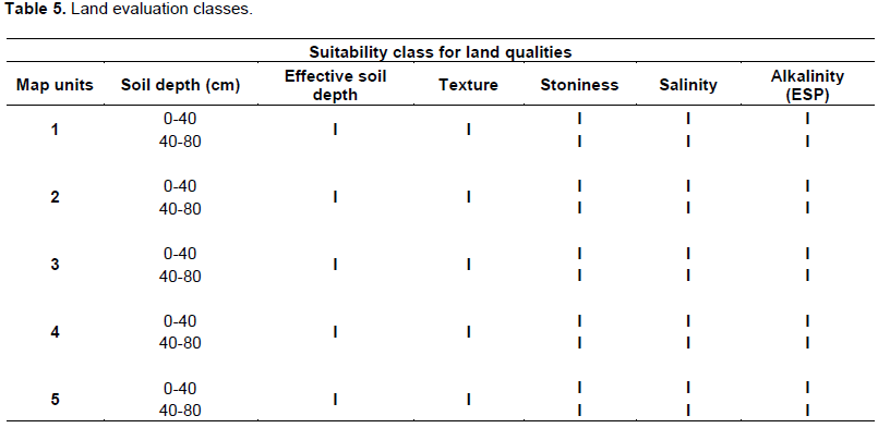
Summary of soil suitability classification results are given in Table 5. Results of soil analysis in the river basin indicated that major part of the area dominated by clay soil. The area characterized by deep soil, clay texture, well drainage condition, top soil stoniness, sub soil stoniness, soil salinity and soil alkalinity. So according to FAO (1976) guideline, in all parts of the areas, soil evaluation parameters are highly suitable for irrigation purpose.
Slope suitability
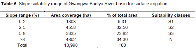
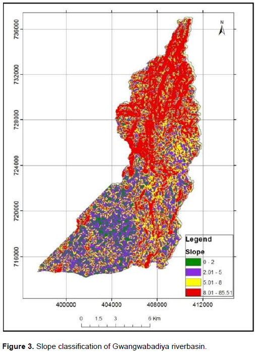
Slope has been considered as one of the evaluation parameters in land suitability for irrigation purpose, based on the four slope classes S1, S2, S3 and N. The result of land suitability of study area for the development of surface irrigation system (Table 6), indicated that 9.32% (1303 ha) are highly suitable, 32.5% (4558 ha) are moderately suitable, 23.82 %( 3335 ha) marginally suitable and 34.30 (4802 ha) are not suitable for surface irrigation systems. Hence, the majority of the study area is highly to marginally suitable for surface irrigation in terms of slope suitability.
Overall evaluation
Sound information on soils, water and other land characteristics provide a basis for decision making on proper utilization and management of natural resources. The importance of land evaluation points to opportunities for influencing future developments of soils in the region using management techniques that are tailored to the characteristics of the landscape elements.
The final objective of the study was to evaluate land suitability for irrigation purpose. The overall result determined based on the analysis of soil characteristics and slope percentages. All land units, soil parameters result depicted that the study area has a deep soil, clay texture, well drainage condition, top soil stoniness, sub soil stoniness, soil salinity and soil alkalinity, which implies highly suitable (S1) for irrigation purpose.
On slope percentages of land suitability show that, the DEM different types of colors were observed. The area with the same color means that those areas have the same surface elevation. The abrupt change of color indicates that there was a difference in elevation within short distance. From the DEM using GIS command (surface) the surface slope of the area was developed. This surface slope then grouped and a slope category was developed. The surface slope was categorized into four slope range, viz, zero to two percent (S1), 2 to 5% (S2), 5 to 8% (S3), and >25% (N) (Figure 3). These slope categories had an area of 1303, 4558, 3335 and 4802 ha, respectively. Based on FAO suitability classification for surface irrigation guideline (1976), 9.32% (1303 ha) are highly suitable, 32.5% (4558 ha) are moderately suitable, 23.82% (3335 ha) marginally suitable and 34.30 (4802 ha) are not suitable for surface irrigation systems. Hence, the majority of the study areas are in a range value of highly to marginally suitable for surface irrigation purpose. Due to high slope range currently 4802 hectares of lands are non-suitable for irrigation purpose.
CONCLUSION
The land evaluation of physical land qualities, chemical land qualities and slope of the study areas indicated that majority of Gwangwa badiya river basins (1303 ha) are suitable for surface irrigation. The factors which were considered for evaluation of the land for surface irrigation of the study area are: Slope of the land, soil depth, soil texture, soil type, soil chemical properties, and drainage nature. The most critical factor that determines gravity (surface) irrigation suitability is slope gradient.
CONFLICTS OF INTERESTS
The authors have not declared any conflict of interests.
ACKNOWLEDGEMENTS
Above all, Glory is to the Almightily God who helped us at every pace of our life and conducting this research. Our particular gratitude goes to Dilla University Research and Dissemination Office for financial and logistics support. We would also like to thank Guangua district Irrigation development and management office heads, experts, development workers and farmers for providing us with valuable information and for their continuous help to carry out this research.
REFERENCES
|
Abaya Woreda Office of Rural Development and Agriculture (2014). Annual Report. Unpublished Report. |
|
|
d'Angelo M, Enne G, Madrau S, perchich L, Pre-Vitali F, Pulina G, Zucca C (2000). Mitigating land degradation in Mediterranean agro-Silvo pastoral systems: a GIS-based approach. Catena 40:37-49. |
|
|
Dent D, Young A (1981). Soil Survey and Land Evaluation.University of East Anglia. Norwich: George Allen and Unwin Ltd. |
|
|
FAO (1976). A Frame Work for Land Evaluation. Soils Bulletin No 32. FAO, Rome. |
|
|
FAO (1979). Land Evaluation Criteria for Irrigation: Report of Land Expert Consultation Held February 1979. Soil Bulletin No.50. FAO, Rome. |
|
|
FAO (1990). Guidelines for soil description. FAO Rome P 69. |
|
|
FAO (1991). Land use planning applications. Proceedings of the FAO Expert Consultation, 1990. |
|
|
FAO (1996). An interactive multi- criteria analysis for land resource appraisal. Rome, Italy. |
|
|
Fasina AS, Awe GO, Aruleba JO (2008). Irrigation suitability evaluation and crop yield an example with Amaranthus cruentus in Southwestern Nigeria. July 2008 Afr. J. Plant Sci. 2 (7):61-66 |
|
|
FDRE (2011). Small-Scale Irrigation Capacity building Strategy for Ethiopia: October 2011. Addis Ababa, Ethiopia |
|
|
Garbrecht J, Martz LW (1999). Comment on "Digital Elevation Model Grid Size, Landscape Representation, and Hydrologic Simulations" by Weihua Zhang and David R. Montgomery. |
|
|
Gupta PK (2004). Soil, Plant, Water and Fertilizer Analysis. Agrobios, India. |
|
|
Landon JR (1991). Booker Tropical soil manual, A hand book for soil survey and agricultural land evaluation in the tropics and subtropics. Longman, Booker/Tate 474 p. |
|
|
Negash W, Seleshi B (2004). GIS based irrigation suitability analysis. J. Water Sci. Technol. Arbaminch Ethiopia 8:55-61 |
|
|
Sahlemdhin S, Taye B (2000). Procedures for soil and plant analysis. National Soil Research Organization, Ethiopian Agricultural Research Organization, Addis Ababa 110 p. |
|
|
Sys I, Van Ranst E, Debaveye J (1991). Land evaluation, part II. Methods in land evaluation. Agriculture publications n.7, General Administration for Development Cooperation. Brussels, Belgium pp. 70-76. |
|
|
Walkley A, Black IA (1934). An examination of the Degtjareff method for determining soil organic matter and proposed modification of the titration method. Soil Soc. 37:29-34. |
|
Copyright © 2024 Author(s) retain the copyright of this article.
This article is published under the terms of the Creative Commons Attribution License 4.0


