ABSTRACT
In this study an economic analysis was conducted to evaluate problem associated with a geographical information system (GIS) using facility location models for the p-median in order to optimize the location of aerodromes for the aerial fertilization (coverage fertilization) of eucalyptus plantations. The location model was tested on a 9,095.65 ha farm located in the Três Lagoas municipality in the Mato Grosso do Sul State, in Brazil. The non-capacitated p-median location model, available in ArcGIS, was evaluated in the location-allocation module. Simulations were performed based on one to five aerodromes. The fertilization and setup costs were calculated for each scenario. The results showed that the p-median location model was efficient in determining the optimal location of aerodromes. The economic analysis of the location model found that the lowest costs are incurred when using three aerodromes.
Key words: Combinatorial optimization, operational research, aerial fertilization.
Forest management can be regarded as management on multiple analysis levels, each involving many decisions based on several resources, most of which are scarce (Church et al., 1998). The productivity of a particular plantation is limited by one or more nutrient sources and forest nutrition is a key part of managing commercial forests (Stape et al., 2006). Fertilization is required because the soil is not always able to provide all the nutrients required by the plants to grow properly (Gonçalves, 1995). Several strategies can be used for the distribution of fertilizers, but the importance of aerial fertilization has been growing owing to the rapid expansion of cultivated areas and the subsequent need for fertilization. Aerial fertilization is highly efficient, particularly in comparison with using terrestrial machinery. One of the main factors that affects the efficiency of aerial fertilization is the distance between the aerodrome and the application area. The ideal aerodrome location is a combinatorial problem involving several possible choices, with limitations on flight distance, refueling, and operational stations, among other restrictions. The network p-median problem, introduced by Hakimi (1964), identifies facility locations in order to minimize the total weighted distance for trips between the demand areas and the facilities.
This problem may be formulated using integer linear programming (Owen and Daskin, 1998) and is useful for predicting the location of industrial plants, warehouses, and public installations (Mladenovic et al., 2007). The tool identifies the locations of facilities in order to minimize the average distance between clients and the nearest service point (Daskin, 1995). The p-median problem has great practical importance. In Brazil, studies have used the technique to examine, for instance, locations for public schools (Pizzolato et al., 2004; Pizzolato and Menezes, 2010), telecommunication antennas (Lorena and Pereira, 2002), public healthcare stations (De Rosário et al., 2001), and urban leisure areas (Brondani et al., 2013; Lorena et al., 2001), as well as for evaluating the integration of location models and Geographical Information Systems (GIS). With regard to forestry areas, the method has been used to identify optimal wood storage locations (Junior et al., 2014; Martinhago, 2012), allocating fire lookout towers in a natural reservoir (Juvanhol, 2015), and for the spatial stratification of compartments in forest harvesting (Gomide, 2013). This study evaluates using the mathematical model associated with the p-median problem to identify optimal aerodrome locations in eucalyptus plantations. In addition, an economic analysis is conducted to find the ideal number of aerodromes for the study area.
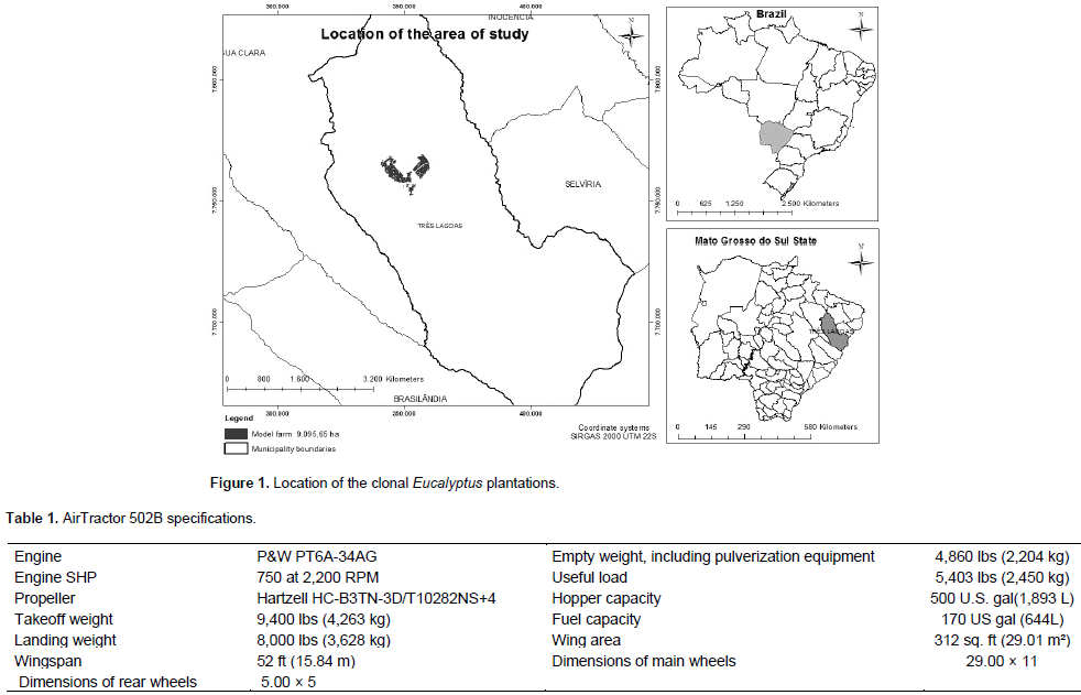
This study focuses on an area of 9,095.65 ha containing clonal eucalyptus plantations in the Três Lagoas municipality in the Mato Grosso do Sul State , Brazil (Figure 1). In these plantations, 200 kg of nitrogen and potassium per hectare are applied between the third and fifth months after planting, using coverage fertilization. The aircraft used is an AirTractor 502B, which has a load capacity of 1,800 kg. The specifications of the aircraft are shown in Table 1. The runways have standard dimensions (that is, 1,200 m long and 40 m wide), and always run in a north/south direction. The optimal aerodrome location problem is modeled as a location-allocation problem, solved using the p-median model of the Location-Allocation module in the extension Network Analyst of ArcGIS version 10.2.2. The available algorithm combines several techniques, adopting vertex substitution heuristics and fine-tuning metaheuristics in order to achieve a satisfactory, optimal, or near-optimal solution (Sultana and Kumar, 2012; Costa, 2014).
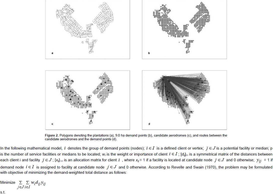
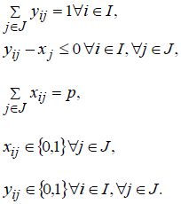
The areas containing clonal eucalyptus plantations are represented by polygons, but in a network context, it is necessary to define demand points in order to draw the routes connecting them to the facility locations. In this case, the demand points are defined as centroids in the intersections between the features of the subject plantation and a grid of 300 m × 300 m polygons created using the Fishnet tool available in ArcToolbox. This made it possible to represent the plot areas on locations corresponding to 9.0 ha plantations, generating a total of 1,013 demand points for the 32 facilities (Figure 2). The study uses the geographical information system ArcGIS® version 10.2.2. The data were created and stored in a geobasis, a native structure of ArcGIS, and stored in a Feature Dataset of the SIRGAS 2000 UTM 22S coordinate system. The extensions Spider Tools, Data Management Tools, Editing Tools, and Network Analyst were used for database processing and structuring, as well as for the required feature editions. According to Revelle and Swain (1970) and Church and Revelle (1976), in a network context, the p-median problem can be defined as follows: minimize the total weighted distance of the trip associated with a network of demand nodes to locate p-facilities in the network (on vertices or on nodes), where each demand vertex is served by its nearest facility.

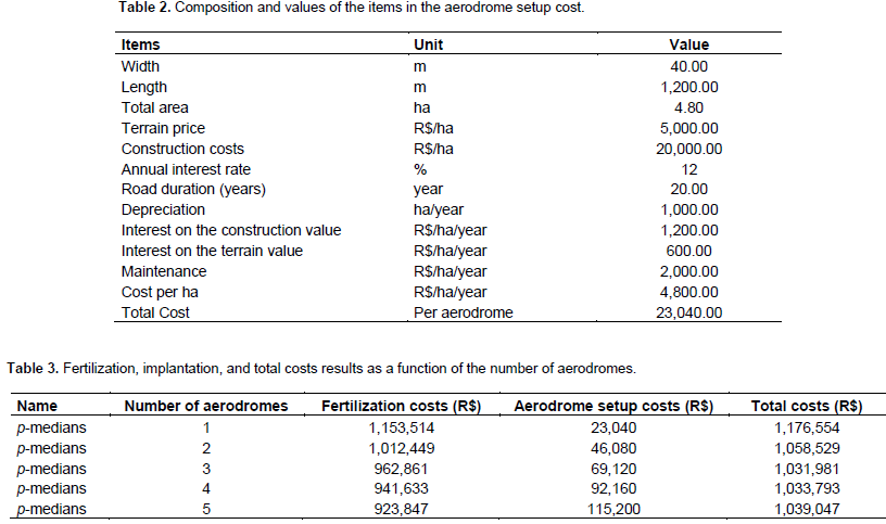
The solution to a facility location problem can be found using a geographical information system integrated with optimization or simulation algorithms. ArcGIS uses heuristic methods to solve the p-median problem, because most location problems are classified as NP-hard. These heuristics were developed by Densham and Rushton (1992), Teitz and Bart (1968), and Arakaki and Lorena (2006). In order to perform the economic analysis, the costs associated with setting up an aerodrome are calculated. Fertilization costs were provided by the company. The cost of coverage fertilization per hectare varies with the coverage radius of an aerodrome. Here, the distances from the plots are distributed into four classes: 2,500, 5,000, 7,500, and 10,000 m. The values provided by the company for the fertilization activity costs, as a function of the distance between the aerodromes and the plots, for radii of 2,500, 5,000, 7,500, and 10,000 m are R$97.5, R$110.0, R$126.9, and R$143.8 per ha, respectively. The total cost of the activity is the sum of the aerodrome setup cost (the same for all points in the study area) and the fertilization cost per hectare.
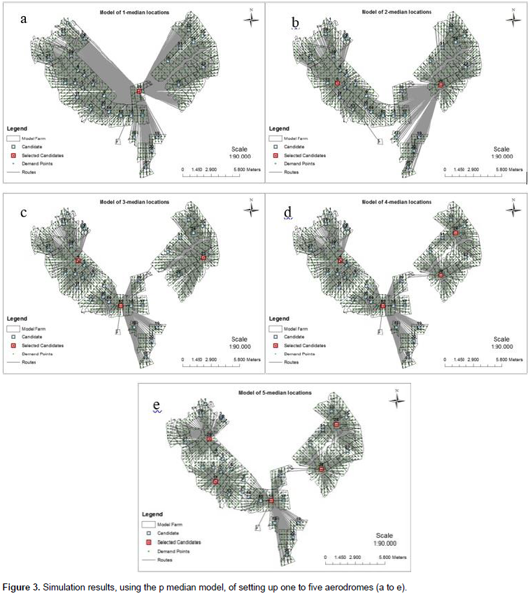
In order to identify the lowest-cost configuration and number of aerodromes, the evaluated location models are used to calculate the aerodrome setup cost and the coverage fertilization cost, which are added together to give the total cost of the activity. Table 2 presents the items making up the aerodrome setup cost, as well as their respective values. A summary of the activity costs is as shown in Table 3. The results show that the scenario with the lowest costs, according to the p-median model, comprises three aerodromes, with a total cost of R$1,031,980.5. When conceptualizing the setup of aerodromes for aerial fertilization, the use of a GIS is important because it enables the results to be presented as illustrative maps. These maps help with the interpretation and comprehension of the results, which are as shown in Figure 3. These results refer to the simulations of setting up one to five aerodromes and to the spatial distribution given by the p-median model.
The location of facilities is a critical problem in strategic planning for several public and private companies. For example, this may involve a producer choosing where to build a warehouse serving a new market in a retail chain, or an urban planner selecting locations for fire stations. In each case, decisions are constrained by the allocation of spatial resources (Owen and Daskin, 1998). Mathematical modeling and optimization have proven to be effective in helping decision-makers with location and transport matters (Kelley et al., 2013). Several recent studies have attempted to define and characterize localization problems and have proposed models to approach and solve these problems (Daskin, 1995; Eiselt and Marianov, 2011). A number of studies use geographical information systems, developing localization models for the establishment of biomass industries (Zhang et al., 2011; Sultana and Kumar, 2012; Costa, 2014; Teixeira et al., 2018). Serra and Marianov (1998)formulated the p-median problem for the location of new facilities in the case of uncertain demand, in terms of time or the distance of trips, where it is possible to define scenarios that represent differences in travel times or demand in the region of interest. For example, the model has been applied to identify the optimal locations of fire brigades in Barcelona. Note that for this study on the location of aerodromes, uncertainty was not taken into account in the evaluated models.
Even though there is considerable research on applying the p-median problem in different scenarios, no studies have examined the setting up of aerodromes in the context of the aerial fertilization of eucalyptus plantations. This technique has proven to be very efficient in finding optimal locations for aerodromes, helping to reduce the associated costs. The results showed that the lowest cost is achieved with three aerodromes, with a reduction of 12.3% in the allocation costs of using one aerodrome (Table 3). The limitation of using the p-median mathematical model is the need to specify the number of facilities being established. In other location models, such as the coverage model, this information is not required; that is, the number of aerodromes is not an input variable in the model. However, this limitation can be overcome by performing simulations that consider different scenarios. The optimal number of aerodromes depends on the plot distribution in the area. In the present study, the distribution favored the location of three aerodromes. Therefore, the decision on runway allocation is directly correlated with the hierarchical planning.
Restricting the number of harvest blocks may favor a smaller number of aerodromes, while excessive specialization may result in the allocation of more aerodromes. Even though they are not analyzed in the present work, the spatial distribution and the number of aerodromes also depend on the physiographical characteristics of the region where the plantations are located, as well as on the size of the forest. However, the methodology employed in this study remains valid and enables the determination of the number and optimal distribution of runways. Only one aircraft type was taken into account in the present study. Given the possibility of acquiring more than one model, the choice of which aircraft to buy can be made based on the total cost (Ellram, 1993), while also considering the useful life of each aircraft type.
The authors have not declared any conflict of interests.
REFERENCES
|
Arakaki RG, Lorena LA (2006). Uma heurística de localização-alocação (HLA) para problemas de localização de facilidades. Production 16(2):319-28.
Crossref
|
|
|
|
Brondani AE, França FAM, Velasco R, Júnior K, Netto POB (2013). Jurkiewicz, S. Alocação de unidades urbanas de lazer por um modelo de p-medianas. Pesquisa Operacional para o Desenvolvimento 5(2):209-223.
|
|
|
|
Church RL, Murray AT, Weintraub A (1998). Locational issues in forest management. Location Sci. 6(1):137-153.
Crossref
|
|
|
|
Church RL, ReVelle CS (1976). Theoretical and computational links between the pâ€median, location setâ€covering, and the maximal covering location problem. Geogr. Anal. 8(4):406-415.
Crossref
|
|
|
|
Costa FR (2014). Modelo de aptidão e de localização-alocação de usinas bioenergéticas utilizando sistemas de informações geográficas. 2014. 62f. Dissertação (Mestrado em Ciência Florestal) - Universidade Federal de Viçosa, Viçosa, MG.
|
|
|
|
Daskin MS (1995). Network and discrete location: Models, algorithms, and applications. New York: Wiley Interscience.
Crossref
|
|
|
|
Densham PJ, Rushto G (1992). A more efficient heuristic for solving largep-median problems. Papers in Regional Sci. 71(3):307-329.
Crossref
|
|
|
|
Rosário R, Carnieri C, Steiner MT, Fleischfresser SA, Correa E, (2001). Aplicação do problema das p-medianas para determinar a localização de unidades de saúde 24 horas. Simpósio Brasileiro de Pesquisa Operacional, São Paulo 33:1155-1166.
|
|
|
|
Ellram L (1993). Total cost of ownership: elements and implementation. J. Supply Chain Manage. 29(3):2-11.
Crossref
|
|
|
|
Eiselt HA, Marianov V (2011). Foundations of Location Analysis. International Series in Operations Research & Management Science. New York, Dordrecht, Heidelberg, London: Springer P 509.
|
|
|
|
Gomide L R (2013). Estratificação espacial de compartimentos via metaheurística simulated annealing em unidades de manejo florestal. SBPO Simpósio Brasileiro de Pesquisa Operacional. Natal/RN. 45:642-651.
|
|
|
|
Gonçalves A L (1995). Substratos para produção de mudas de plantas ornamentais. In: Minami, K. Produção de mudas de alta qualidade em horticultura. São Paulo: T.A. Queiroz.128.
|
|
|
|
Hakimi SL (1964). Optimum locations of switching centers and the absolute centers and medians of a graph. Oper. Res.12(3):450-459.
Crossref
|
|
|
|
Junior MAI, Gomide LR, Silva PH, Alves JAAE, Figueiredo EO (2014). Alocação de pátios de armazenamento de madeira em um plano de manejo florestal na Amazônia ocidental. Anais do XLVI SBPO - Simpósio Bras. Pesqui. Oper. 46:704-713.
|
|
|
|
Juvanhol RS, Da Silva EF, Fiedler NC, Dos Santos AR (2015). Uso de geotecnologias e programação matemática na alocação de torres de incêndios. XLVII SBPO - Simpósio Brasileiro de Pesquisa Operacional, SBPO. Porto de galinhas, Pernambuco-PE. 47:666-676.
|
|
|
|
Kelley J, Kuby M, Sierra R (2013). Transportation network optimization for the movement of indigenous goods in Amazonian Ecuador. J. Transport Geogr. 28:89-100.
Crossref
|
|
|
|
Lorena LA, Senne EL, Paiva JA, Pereira MA (2001). Integração de modelos de localização a sistemas de informações geográficas. Gestão Produção. 8(2):180-195.
Crossref
|
|
|
|
Lorena LA, Pereira MA (2002). A Lagrangean/Surrogate Heuristic for the Maximal Covering Location Problem Using Hillman's Edition. Int. J. Ind. Eng. 9:57-67.
|
|
|
|
Martinhago AZ (2012). Otimização para alocação de pátios de estocagem para exploração de impacto reduzido na Amazônia Brasileira. 162f. Tese de Doutorado em Engenharia Florestal – Programa de Pós-graduação em Engenharia Florestal, Universidade Federal de Lavras – UFLA.
|
|
|
|
Menezes RC (2010). O uso do SIG – Sistema de Informação Geográfico – para o apoio à decisão no planejamento da localização das Escolas Municipais em Guaratiba, Rio de Janeiro. Dissertação de Mestrado, PUC/Rio, RJ.
|
|
|
|
Mladenovic N, Brimberg J, Hansen P, Moreno-Pérez JÁ (2007). The p-median problem: A survey of metaheuristic approaches. Eur. J. Oper. Res. 179(3):927-39.
Crossref
|
|
|
|
Owen SH, Daskin MS (1998). Strategic facility location: A review. Eur. J. Oper. Res.111(3):423-47.
Crossref
|
|
|
|
Pizzolato ND, Menezes R (2013). Localização De Escolas Públicas Em Guaratiba, Rio De Janeiro, Usando Critérios De Acessibilidade. Pesqui. Oper. para Desenvolv. 5(1):71-83.
|
|
|
|
Pizzolato ND, Barcelos FB, Lorena N, Antonio L (2004). School location methodology in urban areas of developing countries. Int. Trans. Oper. Res.11(6):667-681.
Crossref
|
|
|
|
Pizzolato ND, Barros AG, Barcelos FB, Canen AG (2004). Localização de escolas públicas: síntese de algumas linhas de experiências no Brasil. Pesqui. Oper.l 24(1):111-31.
Crossref
|
|
|
|
ReVelle CS, Swain R (1970). Central facilities location. Geogr. Anal. 2:30-42.
|
|
|
|
Serra D, Marianov V (1998). The p-median problem in a changing network: the case of Barcelona. Location Sci. 6(1):383-394.
Crossref
|
|
|
|
Stape JL, Binkley D, Jacob WS, Takahashi EM (2006). A twin-plot approach to determine nutrient limitation and potential productivity in Eucalyptus plantations at landscape scales in Brazil. For. Ecol. Manage. 223(1):358-362.
Crossref
|
|
|
|
Sultana A, Kumar A (2012). Optimal siting and size of bioenergy facilities using geographic information system. Appl. Energy 94:192-201.
Crossref
|
|
|
|
Teitz MB, Bart P (1968). Heuristic methods for estimating the generalized vertex median of a weighted graph. Oper. Res.16(5):955-961.
Crossref
|
|
|
|
Teixeira TR, Ribeiro CA, dos Santos AR, Marcatti GE, Lorenzon AS, de Castro NL, Domingues GF, Leite HG, Mota PH, de Almeida Telles LA, da Silva Vieira R (2018). Forest biomass power plant installation scenarios. Biomass Bioenergy 31(108):35-47.
Crossref
|
|
|
|
Zhang F, Johnson DM, Sutherland JW (2011). A GIS-based method for identifying the optimal location for a facility to convert forest biomass to biofuel. Biomass Bioenergy 35(9):3951-3961.
Crossref
|