Full Length Research Paper

ABSTRACT
Mango cultivation is one of the key economic agricultural activities of fruit in Brazil. In Southern Brazil, mango presents vulnerability thanks to its frost sensitivity, indicating the relevance of climate studies to improve the production and agricultural techniques, in the context of sustainable agriculture and climate change. Agroclimatic zoning should be one of the first information to be considered when starting its cultivation. The objective of this study is to carry out climatic risk zoning for mango tree (Mangifera indica) in the basin of Paraná River III, Brazil. Meteorological data from 43 stations, from 1976 to 2018, were used. The climatic risk analysis was based on the requirements of the mango for precipitation, water balance, average annual temperature, and frost tolerance. The occurrence of frosts is the key restrict factor for production in the area of study. This meteorological factor restricted mango cultivation in the central-eastern portion of the basin. In other areas, the risk is present but the mango cultivation is recommended.
Key words: Climate aptitude, climate variability, agricultural planning.
INTRODUCTION
Fruticulture is an activity that makes a key contribution to the national economic development of Brazil. In this scenario, mango cultivation is one of the agriculture activities, presenting an increasing performance in recent years (Aguiar and Do Nascimento, 2011). Mango tree exhibits droughts periods tolerance; however for the southern Brazil the specie is sensitivity to the occurrence of frosts, demonstrating the importance of agroclimatic studies to improve the production (Olson and Alvarado-Cárdenas, 2016). As a segment of agriculture, mango production presents risks that meteorological elements provide in the variability in production and sensitivity in the management of fruit species (Comer, 2018; Conceição et al., 2018; De Matos et al., 2018; Borges et al., 2019; Medeiros et al., 2018; Dai et al., 2019; Santana et al., 2019; Shezi et al., 2019). The applicability of studies of meteorological elements on a global scale, and the purpose of elaboration of agroclimatic risk zoning is to improve sustainable agricultural management, decision- making, agricultural planning and agricultural policies (Caramori et al., 2008; Ricce et al., 2013; Santi et al., 2018). The agroclimatic risk zoning consists of different levels of scales and exhibits the aptitude and risks from the specific areas for crops cultivation, through maps. The zoning considers the hydroclimatic requirements of each crops species (Ricce et al., 2018; Caldana et al., 2019).
Nowadays, Brazil is the one of the largest world producers and exporters of mango. This agricultural activity is relevant not just for farmers but also to create jobs and income into the national territory, especially in the Northeast (Pereira et al., 2005). Given its economic importance and nutritional value, mango is the seventh most cultivated fruticulture in the world and the third most cultivated in tropical regions, almost 100 countries (Olson and Alvarado-Cárdenas, 2016). In Brazil, only 3.1 thousand hectares are in totally production to insert data from the basin (Ipardes, 2019).
In this sense, it is necessary to study alternatives that promote the climate aptitude of the mango. Meteorological variables are responsible for 80% of the variability of the production of mango. The Paraná State, Brazil, is located in an area of ​​climatic transition, being essential studies of this genesis for agricultural planning and decision making for agriculture in the region (Caramori et al., 2008). The establishment of agricultural planning and more aptitude models is essential for the mango adaptation for cultivation and does not harm the environment using excessive natural resources, in the context of climate change and sustainable agriculture. The purpose of this study is to perform climate risk agricultural zoning for the mango in the hydrographic basin of Paraná River III.
MATERIALS AND METHODS
Climate variability
The hydrographic basin of Paraná River III is located in a Cfa climate, which means that it has a humid subtropical climate according to the Köppen climate classification. This is characterized by the absence of drought seasons and by summers with higher average temperatures. This climate is controlled by air masses from tropical regions (the Atlantic Tropical Mass and the Continental Tropical Mass) and the Atlantic Polar Mass. In addition, the Continental Equatorial Mass can influence the Cfa climate zone during the summer season. Due to the temperature and humidity differences in these climatic masses, the area of the basin is a convergence zone for these climatic front systems, particularly in the winter season period (Nitsche et al., 2019).
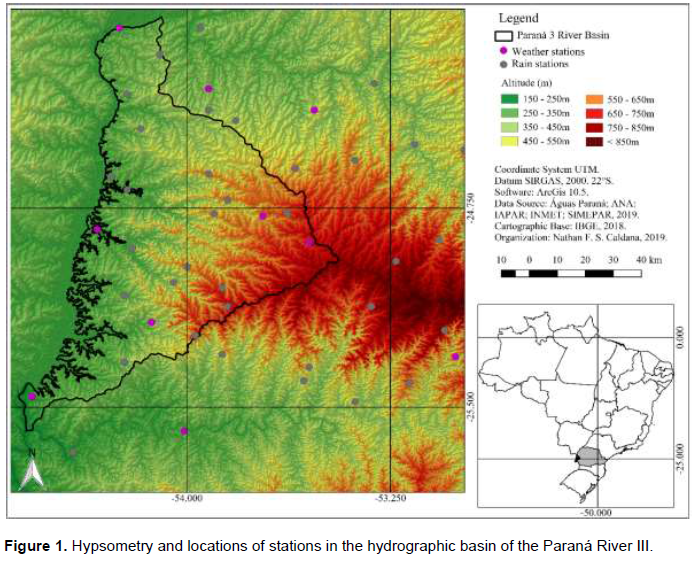
For the purpose of this study, we selected the hydroclimatic requirements of the studied species and weather data of annual, seasonal, monthly, and daily time series with clipping from 1976 to 2018. In order to analyze climate variability and produce the climate risk zoning, data from meteorological stations distributed around the basin were surveyed. The database comprises data from numerous weather stations, including six IAPAR—Instituto Agronomico do Paraná (Brazil) stations (data from 1976 to 2018), ten SIMEPAR—Sistema Meteorológico do Paraná (Brazil) stations (data from 2000 to 2018 were included to contribute to analyses, even though a short period of time), and 27 Águas Paraná (Brazil) stations (data from 1976 to 2018) (Figure 1). For this study, we used data from stations that had long term data series (1976–2018). The spatialization of these data was performed by interpolation, which is an effective method for spatial visualization of climate data. This was done using isohyets and/or by spatially filling the values through adjusted regression statistics, using the inverse distance weighted spatial interpolation algorithm (Lem et al., 2013). The maps were created using QGIS software.
To complement the rainfall variability analysis and to identify the best time for fruit planting and the detection of extremes, Box Plot graphs or box diagram were used. The main feature obtained from its use is to provide a quick view of data distribution. If the distribution is symmetrical the box is balanced with the median positioned in the center of it. For asymmetric distributions, there is an imbalance in the box with respect to the median. The graphics were created using Statistica® software.
Box plots represent five value classifications. Outliers are divided into outliers (values above the maximum, but not extreme) and extremes, with any values exceeding Q3 + 1.5 (Q3 - Q1) or less than Q1 - 1.5 (Q3 - Q1). The highs and lows are considered the highest values in the series, but they are not extreme or discrepant. Inside the box are classified three quartiles with 25% of the data each, in addition to the median value, equivalent to the second quartile, or 50% of the data (Lem et al., 2013).
The punctual data of the rainfall stations were entered into the Qgis software and transformed into a raster file, with aid of the IDW interpolator. This new file displays a regular surface adjusted to these point data of interest with spatial resolution pixel of 1 by 1 km. Subsequently, isohyet and their values were inserted for a better visualization of areas with similar precipitations and/or insolation and to regionalize them. We also evaluated the distribution of annual precipitations using one weather station by region: Missal (West), Cascavel (South) and Vera Cruz do Oeste (Center), Foz do Iguaçu (South) and Terra Roxa (North). The Shuttle Radar Topography Mission - SRTM base, at 30 m resolution was used together positioning to correct the influence of the topography on temperature. This method is needed to spatialize and regionalize data to areas that do not have temperature data with greater accuracy. Multiple linear regression equations were applied for the spatialization of the average temperature and frost data measured at the meteorological stations. The applied equation is given by:
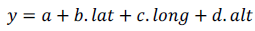
where  are regression coefficients, and lat, long, and alt represent the latitude, longitude and altitude, respectively.
This mathematic formula was applied in Arcgis geoprocessing software over the SRTM file, making it possible to generate maps, with spatial resolution of 30 m. The method used for the probability of frost was based on the historical minimum temperature series recorded within the meteorological shelter. We determined the probabilities of values equal to or lower than 1.0° C and then also adjusted to the equation
Rainfall data (from the monthly totals of each year) and the monthly average temperature (from the monthly averages of the daily values of each year) were extracted. Then, potential evapotranspiration (PET) was calculated according to the Thornthwaite method. First, the standard potential evapotranspiration (PET, mm/month) was calculated using the empirical formula:
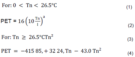
Where Tn is the average temperature of month n (n = 1 is January, n = 2 is February, etc.) in °C, and I is an index that expresses the heat level of the region.
The value of I depends on the annual temperature cycle, integrating the thermal effect of each month, and is calculated using the formula,

The exponent “a”, being a function of I, is also a regional thermal index, and is calculated using the expression

The PET value represents the total monthly potential evapotranspiration that would occur under the thermal conditions of a standard 30 day month, and with a 12 h photoperiod (N) each day. Therefore, PET should be corrected for N and the number of days in the period.
Agroclimatic risk zoning
The risk factors selected for agricultural zoning of climatic risk were:
i) Average annual precipitation: data on monthly and annual precipitation from meteorological series of 27 stations in the basin were selected. The results obtained were interpolated in a geographic information system for the generation of maps with the regionalization of data through the IDW. It was considered: High Risk: annual rainfall less than 1,500 mm and as low risk greater than 1,500 and less than 1,900 mm annual distributed during the year (Mouco, 2010; Moura et al., 2015).
ii) Average Annual Temperature (Ta): We used meteorological data from historical series of average temperatures observed inside meteorological stations to estimate the average annual temperature. Using the Ta value, regression was applied as a function of latitude, longitude, and altitude for the whole basin. The risk classes defined for Ta were as follows: high risk – less than 20°C and low risk: greater than 20°C (Mouco, 2010; Moura et al., 2015).
iii) Annual Water Deficiency (AWD): This was estimated using the method of Thornthwaite and Matter (1955), and obtained by calculating the normal climatological water balance for the meteorological stations. We used a value of 100 mm for the available water capacity in the soil, considering that the avocado root system explores the soil profile to a depth of more than 1.50 m (Coelho et al., 2001). The results obtained were interpolated using the ArcGIS 10.0 geographic information system to generate the annual water deficit maps. (High Risk: AWD in two consecutive months > 10 mm, and Low Risk: AWD <10 mm in less than two consecutive months (Pereira et al., 2005; Mouco, 2010).
(iv) Frost risk: We used meteorological data from the thirteen-season historical series, taking into account occurrences of temperatures of 1 °C or below as observed within the meteorological shelters, to calculate the risk of frost. The probabilities of annual frost occurrence were calculated and correlated with altitude and latitude, obtaining a regression equation for the risk of frost. Using adjusted regressions, values greater than 20% were considered to be high risk (Pereira et al., 2005; Mouco, 2010).
For the creation of thematic maps and the final zoning map, ArcGIS software was used. Firstly, the numerical values from the meteorological stations were transformed into points, according to their geographical coordinates. We then used the edaphoclimatic requirements of the avocado species to produce data spatialization, which was used for the delimitation of the representative bands of the avocado climate requirements. Thus, the station values were replaced by “1. Apt” or “2. Restricted”, according to the physiological requirements for each meteorological variable analyzed. The next step was to combine the matrix images. Each pixel was assigned with the values “1” or “2”, as already described. If the combination for a point was filled only with values “1”, the region was classified as fit. If it had a value of “2” it was restricted by a given variable. If two or more “2” values were assigned, the location was classified as unfit. Then, standardization of the pixels using classifications was performed by dissolving the vector classes. In this way, the agroclimatic zoning classes were grouped, thus defining regions of suitability for the studied species. The final map showing the agroclimatic zoning of each crop will provide an estimate of the representative area of each risk class, ensuring its suitability for the site.
RESULTS AND DISCUSSION
In terms of water requirements, the mango is significantly resistant to drought, thanks to its root system that is capable of reaching depths into the soil, surviving up to 8 months without precipitation. Cultivation regions include areas that present low rainfall and high evapotranspiratory demand impose vegetal water supply through the irrigation. In these conditions, even when irrigated, the mango is into certain of water deficiency. Excessive precipitation, on the other hand, combined with high temperatures, makes the mango susceptible to fungal diseases and pests, and it is convenient that no precipitation occurs during the developing phase.
A dry period preceding flowering favors production, however, the mango requires edaphic moisture from the beginning of fruiting to maturation, which also influences the promotion of new vegetative growth (Mouco, 2010). In regions with low precipitation, irrigation is recommended based on the water requirements (Pereira et al., 2005). The estimated precipitation for the complete cycle development of the species in the region ranges from 1,500 to 1,900 mm, with annual values ​​higher than the latter, favoring the proliferation of fungal pathologies (Figure 2).
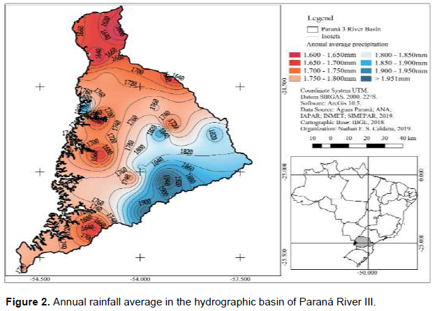
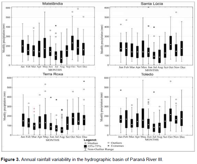
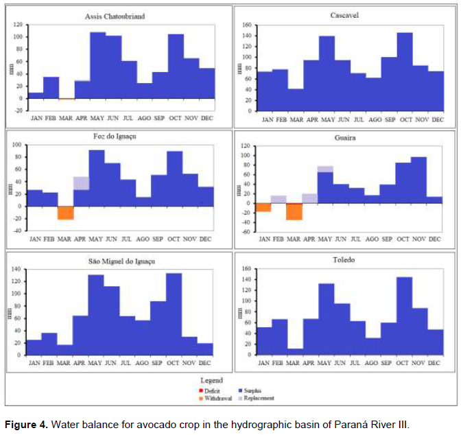
Precipitation in the basin of Paraná River III was restricted only in the eastern portion, for mango production. The highlighted variable does not guarantee inaptitude. In addition, the mango needs a droughts period for better development during the flowering season. The precipitation occurrence at the time of flowering causes a series of damages such as: the removal of the pollen grain deposited in the stigma; dilutes stigmatic fluid favors loss of viscosity and non-retention of pollen; contributes to the fall of flowers and fruits; harms insect pollination and it also favors the proliferation of diseases such as powdery mildew and anthracnose (Mouco, 2010) (Figure 3). The region has no defined dry season; the driest month by the monthly average was August in municipality of Terra Roxa, with 56 mm. There is a significant discrepancy between the wettest and driest months, as in municipality of Matelândia, October has a median of 213 mm and August 65 mm. This difference between monthly rainfall during summer and winter may favor mango production. Mango is a drought-resistant species. This vegetation and fruit are found in regions of the Brazilian semiarid where the rainfall reaches 240 mm (Pereira et al., 2005). However, for the commercial success, it is recommended that the species does not spend more than two consecutive months under water stress; therefore, it is established that for zoning, the limit of two months under deficiency greater than 10 mm is restrictive for cultivation. Although summer is the rainiest season in the region (Figure 4), it is in this period that the highest temperature and evapotranspiration records occur (Nitsche et al., 2019); so even though winter is the driest season, the summer exhibits water deficiency in the region of the study. As identified, none of the analyzed stations presented AWD in two consecutive months, presenting no risk to production. Even in the Guaíra station, in the driest portion of the region, the annual deficit is no more than 60 mm. The spring months are the ones with the highest surplus volume, mainly in October.
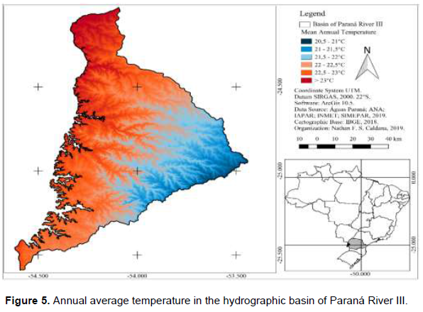
Temperature is the most important climatic factor for mango cultivation, mainly due to the influence on flowering. The low temperatures paralyze the growth of the mango, of fundamental importance for the occurrence of flowering. Plants tend to grow, in vegetative phase and bloom irregularly in high temperature conditions (> 30°C day / 25°C night). At 15°C the growth of the branch already stops, stimulating intense flowering. The initiation of flower buds depends on the cold days that occur from June to October, in the Southern Hemisphere (Pereira et al., 2005). The temperature showed no restrictions for the mango cultivation (Figure 5). The lowest records occurred in the portion with the highest altitudes (Figure 1) with an average temperature around 20.5°C; as the restriction evaluated was 20°C, there was no risk. In the western direction of the basin, the average values ​​exceed 23°C.
In subtropical conditions, fruticulture management becomes relatively easy due to low temperatures facilitating flowering induction, although fruit growth and quality can be compromised by these temperatures (Sarkhosh et al., 2018). The sleeve cannot withstand temperatures below 10ºC. For this reason, the Southeast and Northeast regions of the country account for more than 90% of national production. Thus, the occurrence of frost becomes extremely harmful to production, since it leads to senescence, even if the tree survives, thus making production unfeasible (Mouco, 2010). It was identified that the region presents a risk of frost throughout its area (Figure 6). However it presents great regional variation. In the eastern portion of the basin, close to municipality of Cascavel, the probability is more than 25% of the occurrence of frost per year. While in the west direction, towards the Paraná River channel, the risk is reduced to less than 5%.
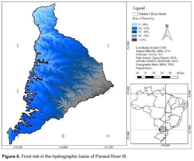
The cultivation of mango is not recommended in areas that present frost risk more than 10%, representing more than one strong frost every five years. The only area capable of presenting a lower risk is at the edge of the Paraná River, where the altitudes do not exceed 300 m, as presented in Figure 1. The final map of the agroclimatic risk zoning of the mango (Figure 7) presents the union of the agroclimatic maps presented in this study to determine the aptitude in the basin of Paraná River III. As noted that mango is a sensitive frost specie, the occurrence and frequency of frost was the key variable that restricted the cultivation of mango in the region, making only the extreme west portion of the basin apt for cultivation.
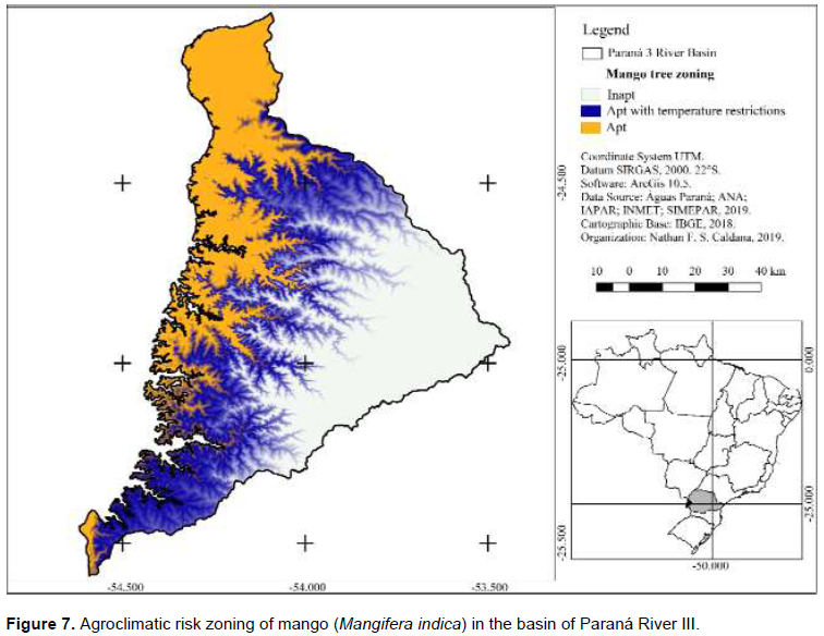
In addition, the region is a small area, on the blue strip of the zoning map, where the risk of frost ranges from 10 to 15 %. Management agricultural practices must be taken to protect the orchards and avoid harm. Even in suitable regions, the risk of frost remains, so the farmer should avoid valley bottoms, at the end of the slopes, and give preference in areas that are not very sloping, to facilitate the displacement of cold air. Preferably, the top of the spike and half slope should be used, mainly on the faces facing north, since, as highlighted, the cold front has preferential displacement in the south / southwest direction, northeast direction (Caldana et al., 2019a, b). It should be noted that zoning does not eliminate the risks, but only presents more favorable conditions for the development of mango orchards. As agriculture is a risky activity, all activities are susceptible to climate extreme events, which may or may not cause harm for the farmer. In the context of sustainable agriculture, agroclimatic zoning provides greater security in decision-making, agricultural planning, and climate change scenarios, in the hydrographic basin of Paraná State III.
CONCLUSIONS
(i) The Hydrographic basin of Paraná River III has a small region with low climatic risk for mango cultivation, especially in areas with lower altitudes.
(ii) Mango is extremely sensitive to low temperatures and frost. The cultivation is restricted to a significant part of the basin. Even in suitable areas, the farmer must avoid cultivating in lowland areas with slopes facing the South side, thanks to the entry of cold air masses in the Paraná State.
(iii) Precipitation and water balance present sufficient values in all scenarios studied, however, during droughts periods, the farmer can use irrigation system.
(iv) Agricultural management techniques can be taken to avoid the risk of frost and to avoid areas with a higher incidence of the phenomenon can guarantee success in the cultivation of mango in the basin of Paraná River III.
CONFLICT OF INTERESTS
The authors have not declared any conflict of interests.
ACKNOWLEDGMENTS
The authors thank the Itaipu Binacional and the FAPEAGRO (Fundação Apoio a Pesquisa e Desenvolvimento do Agronegócio) for granting a scholarship to the first author.
REFERENCES
|
Aguiar WMM, Do Nascimento AS (2011). Análise dos custos do programa de controle das moscas-das-frutas na cultura da manga no polo frutícola do Vale do Rio Brumado, BA. Embrapa Mandioca e Fruticultura-Artigo em periódico indexado (ALICE). |
|
|
Borges CV, Belin MAF, Amorim, EP, Minatel IO, Monteiro GC, Gomez HAG, Lima GPP (2019). Bioactive amines changes during the ripening and thermal processes of bananas and plantains. Food Chemistry 298:125020. |
|
|
Caldana NFS, Nitsche, PR, Martelócio AC, Rudke AP, Zaro GC, Batista Ferreira LG, Martins JA (2019a). Agroclimatic Risk Zoning of Avocado (Persea americana) in the Hydrographic Basin of Paraná River III, Brazil. Agriculture 9(12):263. |
|
|
Caldana NFS, Rudke, AP, Da Silva I, Nitsche PR, Caramori PH (2019b). Gênese, Impacto e a Variabilidade das Precipitações de Granizo na Mesorregião Centro-Sul Paranaense, Brasil/Genesis, Impact and Variability of Hail Precipitations in the Central South Mesoregion of the State of Paraná, Brazil. Caderno de Geografia 29(56):61-61. |
|
|
Caramori PH, Caviglione JH, Wrege MS, Herter FG, Hauagge R, Gonçalves SL, Ricce WD S. (2008). Zoneamento agroclimático para o pessegueiro e a nectarineira no estado do Paraná. Revista Brasileira de Fruticultura 30(4):1040-1044. |
|
|
Comer PJ (2018). Ecoregional planning and climate change adaptation. The Encyclopedia of the Anthropocene 2:245-256. |
|
|
Conceição MAF, Tonietto J, de Souza RT (2018). Índices hídricos climáticos para a viticultura. Pesquisa Agropecuária Brasileira 53(6):765-768. |
|
|
Dai H, Zhang Y, Ma L, Zhang H, Huang H (2019). Synthesis and response of pineapple peel carboxymethyl cellulose-g-poly (acrylic acid-co-acrylamide)/graphene oxide hydrogels. Carbohydrate Polymers 215:366-376. |
|
|
Lem S, Onghena P, Verschaffel L, Van Dooren, W (2013). The heuristic interpretation of box plots. Learning and Instruction 26:22-35. |
|
|
de Matos RM, da Silva PF, Borges VE, Sobrinho TG, Neto JD, Saboya LMF (2018). Agroclimatic Potential For Mango Culture in the Municipality of Barbalha CE. Revista Brasileira de Agricultura Irrigada 12(1):2366. |
|
|
Mouco MAC (2010). Cultivo da mangueira. Embrapa Semiárido-Sistema de Produção (INFOTECA-E) 2:111. |
|
|
de Moura MSB, Oliveira LDS., Evangelista SRM, Mouco MDC, De Souza LSB, Silva T (2015), Aptidão climática da mangueira frente ao clima atual e aos cenários futuros. Revista Brasileira de Geografia Física 08:496-509. |
|
|
Nitsche PR, Caramori PH, Ricce WDS, Pinto LFD (2019). Atlas Climático do Estado do Paraná. Instituto Agronômico do Paraná. Disponível em: |
|
|
Olson ME, Alvarado-Cárdenas LO (2016). ¿ Dónde cultivar el árbol milagro, Moringa oleifera, en México? Un análisis de su distribución potencial. Revista mexicana de biodiversidad 87(3):1089-1102. |
|
|
Pereira MEC, Fonseca N, Souza, FVD (2005) Manga: o produtor pergunta, a Embrapa responde. Área de Informação da Sede-Col Criar Plantar ABC 500P/500R Saber (INFOTECA-E), 1:184. |
|
|
Ricce WDS, Caramori PH, Roberto SR (2013). Potencial climático para a produção de uvas em sistema de dupla poda anual no Estado do Paraná. Bragantia 72(4):408-415. |
|
|
Ricce WS, Roberto S, Tonietto J, Caramori PH (2018). Agroclimatic zoning for winemaking grape production in the State of Parana. Agronomy Science and Biotechnology 4(1):14. |
|
|
Santana I, Castelo-Branco VN, Guimarães BM, de Oliveira Silva L, Peixoto VODS, Cabral LMC, Torres AG (2019). Hass avocado (Persea americana Mill.) oil enriched in phenolic compounds and tocopherols by expeller-pressing the unpeeled microwave dried fruit. Food Chemistry 286:354-361. |
|
|
Santi A, Vicari MB, Pandolfo C, Dalmago GA, Massignam AM, Pasinato A (2018). Impacto de cenários futuros de clima no zoneamento agroclimático do trigo na região Sul do Brasil. Agrometeoros 25(2):303-311. |
|
|
Sarkhosh A, McConchie C, Khadivi A (2018). The effects of different tip-pruning times on flowering, yield, and maturity of two mango cultivars in subtropical climate of Northern Territory (Katherine region) from Australia. Scientia horticulturae 234:140-145. |
|
|
Shezi S, Magwaza LS, Mashilo J, Tesfay SZ, Mditshwa A (2019). Photosynthetic efficiency and relationship to mesocarp dry matter content of 'Carmen'avocado (Persea americana Mill.) fruit in a cool subtropical climate. Scientia Horticulturae 253:209-216. |
|
|
Thornthwaite CW, Mather JR (1955). The water balance. Centerton: Drexel Institute of Technology, Laboratory of Climatology, 1955. 104p. Publications in Climatology 8:1. |
|
Copyright © 2024 Author(s) retain the copyright of this article.
This article is published under the terms of the Creative Commons Attribution License 4.0


