Land is a complex and dynamic combination of factors vis-à-vis geology, topography, hydrology, soil, microclimates and communities of plants and animals that are continually interacting under the influence of climate and people’s activities (Hudson, 2005). The variation in land must be identified, characterized and information communicated via the most inclusive and cost effective means if people understand the different forms of land use, the hazards due to accelerated changes and degradations that accompany those uses. Information on the constraints and opportunities for the use of land will provide basic tools for better crop management practices and guides decisions on optimal utilization of land resources in a sustainable way (Nayak et al., 2010).
Van Ranst et al. (1996) pointed out that physical land suitability is a prime requisite for land use planning development, since it guides decisions on land utilization type for optimal use of land resources which contributes towards better land management, mitigation of land degradation and designing land use pattern that prevents environmental constraints through isolation of rival land uses. Making effective decisions regarding agricultural land suitability problems are vital to achieve optimum land productivity and ensure environmental sustainability (Oluwatosin, 2005; Kurtener et al., 2008; Teshome et al., 2013). In contrast, the incongruous use of land has resulted in environmental degradation of natural resources that leads to decline in land productivity and deterioration of soil quality for its future use (Menale et al., 2008).
Due to the ever increasing population pressures and heavy reliance of their own land resources, the unreceptive use of land and environmental sustainability of agricultural production systems have become an issue of concern (Gong et al., 2012; Singh, 2012). Land should be used based on its capacity and fitness to meet human needs and to ensure sustainable agricultural service. The sustainability of agriculture, which involves producing quality crops in an environmentally friendly, socially acceptable and economically feasible way, would be achieved if lands could be categorized and utilized based upon their capacity (Amiri and Shariff, 2011).
To obtain optimum benefit out of the land, proper utilization of its resources is inevitable. Various studies (Rossiter, 1996; Ziadat and Al-Bakri, 2006; FAO, 2007; Ritung et al., 2007; Braimoh and Vlek, 2008) addressed that land evaluation is initiated from the need for an ample assessment of land performance when used for specified purposes using a scientific process which involves the execution and clarification of surveys and studies of landforms, soils, climate, vegetation and other aspects of land. Land evaluation employs estimating the land resources and grouping for a defined use in terms of their appropriateness that have vital roles for potential agricultural efficiency and sustainable land use planning. It facilitates the full utilization of the land resources at a regional level with specified land qualities or land characteristics as a land unit, which can be mapped and serially numbered (like land unit 1, land unit 2, land unit 3, and so on).
There are several approaches to land suitability evaluation for which Van Lanen (1991) identified three general types. The first one is qualitative evaluation based mainly on expert judgment, where physical suitability is obtained by qualitative procedure. This approach gives a useful result that generalizes the constraint of an area for specific kind of land use type. The FAO (1976) framework for land suitability evaluation is a typical example. The approach is presented in discretely ranked classes (e.g. S1, S2, S3, N1 and N2). This concept of FAO is mostly applied, and, although it is qualitative, it can be complemented and enhanced by more quantitative methods (Teshome and Verheye, 1995). The second type includes a qualitative evaluation based on parametric methods that assess the suitability of land on a continuous scale. The essentials of these methods can be expressed by a mathematical model. The Storied index (Storie, 1933) is an example. The third method is that based on process-oriented simulation models where land performance is related to individual land characteristics with their net effect assessed using a model of land function.
These quantified methods usually require high data input, which make them more expensive. Of all the different approaches to land evaluation, each has different data needs and different qualities of prediction. There are no rules that indicate when any given approach is adequate, or when there is the need to proceed to a more complex level of analysis (Burrough, 1996). Therefore, in developing countries where inadequate land resources data exist and funds are limited to do detailed data analysis, qualitative physical land suitability evaluation methodology may be used, which may later be complemented with a more complex quantitative methods.
In Ethiopia, limited numbers of investigations were made to assess the land suitability based on their agricultural potentials or their physical land resources. These studies conducted on land evaluation of the country seem to be inadequate in providing Wadla Delanta basic information that can guide land use decisions on proper utilization of resources. For instance, very few studies (Teshome and Verhey, 1994; Mohammed, 2004; Kassa and Mulu, 2012; Abraham and Azalu, 2013; Teshome et al., 2013; Gizachew, 2014) were conducted to evaluate suitability of land for a given use across different parts of the country. In the study area, population pressure is increasing from time to time, while the productivity of land is declining. Agricultural production in the area has, thus, become unsustainable; marginal lands are being converted into cultivated lands. It is imperative to evaluate the potential of such marginal lands to decide potential, limitations and their suitability. This will ensure sustainable use with better return from the land. Nevertheless, although production of crops has been practiced for many years, the potential and constrains of the land has not been identified scientifically. As a result, productivity has remained extremely low in the study area.
Thus, to fill this gap, the present study was conducted to identify the potentials and constraints of the land fo
production of major crops in Wadla Delanta Massif of north central highlands of Ethiopia with the intention of providing scientific information that can be used for future sustainable land use planning and development.
Description of the study area
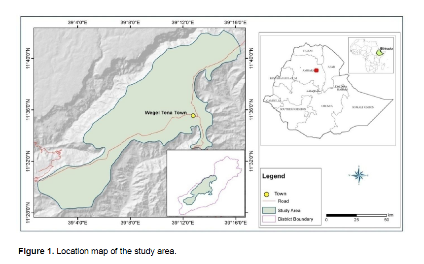
The study was conducted at the Wadla Delanta Massif in Delanta district, northcentral highlands of Ethiopia (Figure 1). The study area lies between 11° 29' 29.82" to 11° 41' 25.53" latitude and 39° 02' 19.19" to 39° 19' 53.74" longitude with elevation ranges from 2600 to 3500 m above sea level and covering an area of 24,025 ha. It is located at about 499 km north of Addis Ababa and 98 km northwest of Dessie town, South Wello Zone
According to the information obtained from the WAOR (2013), the total area of the District is 105678 ha stretching from lowland to highland, much of it being in the mid-altitude ranges dominantly plateau plains. Average land holding size is one hectare per household (0.75 ha for crop production and 0.25 ha for grazing) and their major sources of traction for ploughing are oxen. Among the total area of the District, 24025 ha was covered by this study along toposequence which was mainly situated in plain areas with altitude ranges from 2600 to 3500 masl in the north, northwest and west from the center of the District town (Wegel Tena).
Geomorphology and topography of the study area
The major landforms of the study area comprise extensive plateaus, chains of hills with mountainous ridge, oval in shape with dendritic drainage pattern, numerous convex hills at the plain area, river-valleys and very deep gorges at the boundary. About two-third of the area, embracing altitude ranges from 2100 to 3500 m, was highly populated. The remaining one third of the District is located mainly along the river valleys on the east, southeast, north and northwest location which range from 1500 to 2100 m. Topography of the highland plateaus, especially those elevated above 3000 m are dominated by chains of hills. According to WAOR (2013) reports, the general classification of the area is about 30% mountainous, 30% plains, 36.5% gorges and 3.5% other land features.
Climate and land use systems of the study area
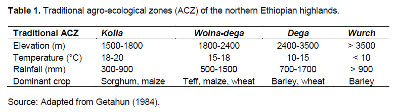
The traditional agro-ecological classification of the study area falls in all the categories that are basically correlated with elevation. These are Kolla, Woina-dega, Dega and Wurch (Table 1). The climate of the area is characterized by dry seasons (October to February Cold-Dry and March to June Hot-Dry) and wet season (mid-June to September).
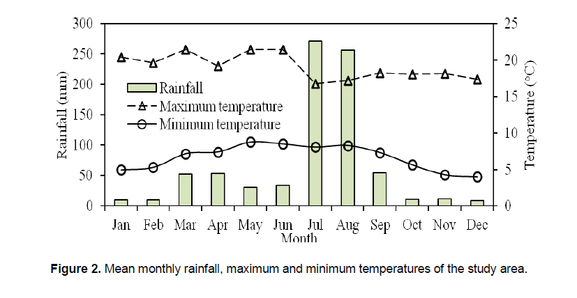
The rainfall pattern is bimodal with peak periods from mid July to early September. For fifteen years (1999 to 2013), mean annual rainfall of the study area was about 812 mm of which 60 to 70% is received in summer (Kiremt) and 40 to 30% in the spring (Belg) seasons. The mean annual minimum and maximum temperatures are 6.8 and 19.6°C, respectively (Figure 2). People are living in the upper topographic position and their farming activities primarily depend on Belg rains, whereas the middle and lower topographic positions rely on both the Kirem and Belg rains. As a result, there is small, erratic and unreliable rainfall and the area is prone to sporadic droughts.
The land use systems in the area are both private (farming) and communal (grazing) land holdings which can be identified through land use patterns. Cultivated and grazing lands are the major land use types in the area which account 22 and 8%, respectively.
The largest proportion (45%) of the land in the study area is currently unutilized and the remaining (25%) is covered by shrub/bush, and natural and plantation forests. Agriculture is the predominant economic sector which is over 95% of the population engaged in this sector (WAOR, 2013). The farming system is mixed which include livestock and crop production activities and is characterized by subsistence methods. The overall farming system is strongly oriented on the way of crop production to sustain farmers’ livelihoods. It is practiced using oxen and horses for land ploughing and threshing. Crop residues and intensive grazing are major livestock feed resources in the area.
The common rainfed crops grown in the area are bread wheat (Triticum aestivum L.), food barley (Hordeum vulgare L.), faba bean (Vicia faba L.), lentil (Lens culinaris L.), grass pea (Lathyrus sativus L.), chickpea (Cicer arietinum L.) teff (Eragrostis tef L.) and sorghum (Sorghum bicolor (L.) Moench. All these crops are managed using traditional agricultural techniques and equipment. Moreover, few types of vegetables, fruits, root crops and spices are also produced. Most of the arable land is under rainfed farming while very small area is irrigated at the valley bottom or around riverbanks to produce vegetables and fruits (WAOR, 2013).
The natural woodland and vegetation of the study area has disappeared due to overgrazing, increasing demand for fuel-wood and conversion into cultivated lands. There are small patches of remnant natural forests found on farm boundaries and around churches. Planted tree species like Eucalyptus camaldulensis, Cupressus lustanica, Acacia saligna and Acacia decurrens are common around homesteads and conserved areas. The Eucalyptus camaldulensis plantations are replacing the arable/cultivated lands and expanding on backyards, stream banks and gully sides.
Geology and soils of the study area
Geology of the study area is characterized by the trap series of tertiary periods, similar to much of the central Ethiopian highlands (Mohr, 1971). As per Dereje et al. (2002), the area is covered by Oligocene rhyolite and very thick ignimbrite units encompassing predominantly of alkaline basalt with numerous inter-bedded flow of trachyte. The granite, gneisses and basalt rock types exist in the area forming part of the basement complex and most of the soils are basaltic parent material. Soils of the study area are greatly influenced by topography with high surface runoff during the main rainy season. There was no scientific studies in the area except FAO/UNDP (1984) small scale soil survey (1:1 000 000 scales) at the national level. The local people have traditionally classified the soils, namely Walka or Mererie Afer (Vertisols) in the plain area and Nechatie or Gracha Afer (Cambisols and leptosols) in steep slope or mountainous area.
Description and characterization of land mapping units
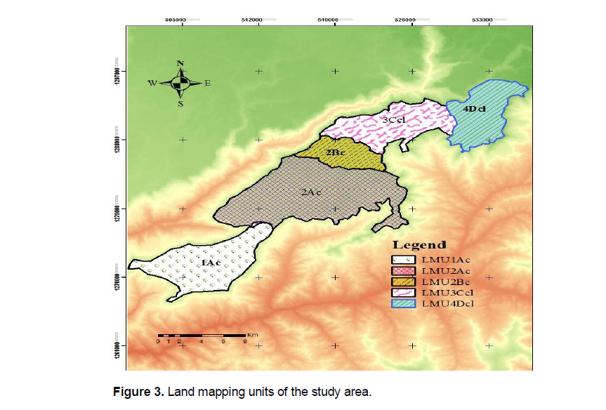
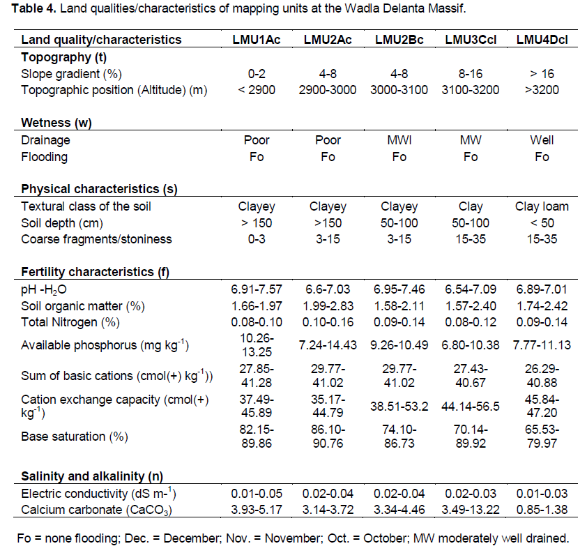
Land mapping units (LMUs) were selected on the basis of slope, soil depth and textural classes, as well as morphological, physical and chemical characteristics which were considered in terms of soil fertility. As a whole, the study area was classified into five land units, three topographic positions, three soil depths and two textural classes. Twelve representative pedons were opened along the topographic position and classified according to WRB (2006) as Calcic Vertisols, Pellic Vertisols, Haplic Cambisols and Mollic Leptosols (Table 2).
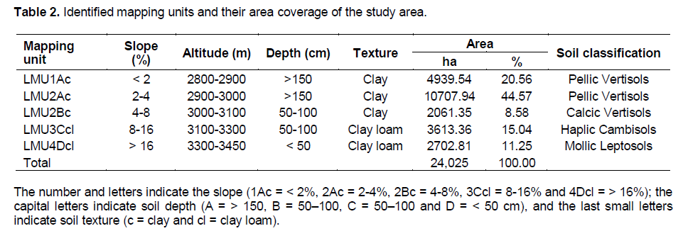
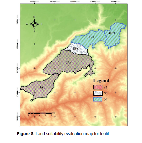
The number and letters indicate the slope (1Ac = < 2%, 2Ac = 2-4%, 2Bc = 4-8%, 3Ccl = 8-16% and 4Dcl = > 16%); the capital letters indicate soil depth (A = > 150, B = 50–100, C = 50–100 and D = < 50 cm), and the last small letters indicate soil texture (c = clay and cl = clay loam). For the qualitative land suitability evaluation, simple limitation method was applied. Based on this method, land suitability classes were determined for T. aestivum L., H. vulgare L., V. faba L. and L. culinaris L. crops. For the purpose of land suitability evaluation, the twelve pedons were further categorized into five land mapping units (Figure 3).
Land suitability evaluation procedures for rainfed crop production
Land utilization type and their requirement
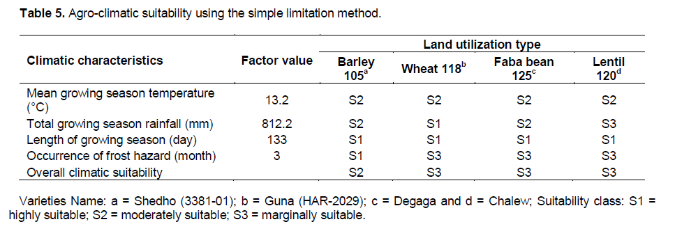
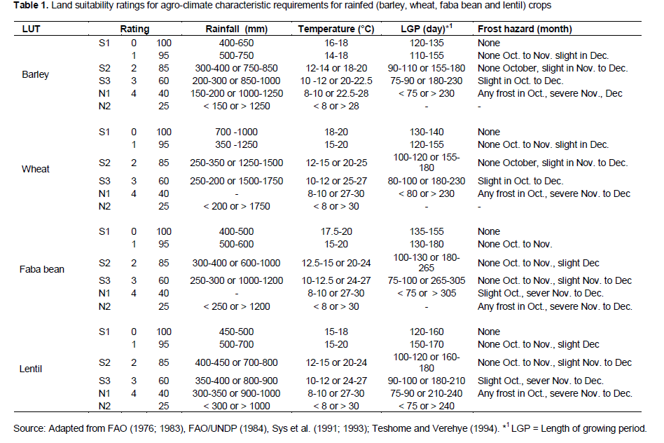
In this study, different physical land resources such as soil, climate, hydrology and topography were evaluated based on the simple limitation (matching system) approach between land quality and land characteristics with crop requirements. To obtain information on potential and limitations of the land in the study area for rainfed crop production, four principal crop varieties (Guna-HAR-2029 for T. aestivum L, Shedho-3381-01 for Hordeum vulgare L., Degaga for V. faba L. and Chalew for L. culinaris L.) were selected as priority land utilization types (Table 3) and the land use requirements of each crop were established using FAO (1976, 1983), FAO/UNDP (1984b), Sys et al. (1991, 1993) and Teshome and Verhey (1994) procedures.
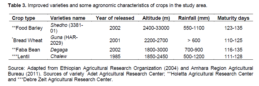
The average lengths of the crop varieties’ cycles for bread wheat (T. aestivum L.), food barley (H. vulgare L.), faba bean (V. faba L.) and lentil (L. culinaris L.) were taken as 129, 103, 125 and 119 days, respectively (EARO, 2004; ARAB, 2011). The selection of varieties were made based on their dominance (area coverage) and importance in the area, but low productivity as per the information obtained from discussion held with the agricultural experts of the local district and information obtained from farmers.
Agro-climatic analysis for determination of growing period
The length of growing period of the study area was defined by comparing decadal rainfall with reference evapotranspiration (ETo). The beginning of growing period, end of rains, start and end of the humid period were determined using graphic method as described by Sys et al. (1991b). The growing period starts as the rainfall amount is greater than or equal to half of the reference evapotranspiration (RF ≥ 0.5ETo) during the beginning of the rainy season and the end of the rainy seasons was set when the rainfall amount during the end of season is again less than half of the corresponding reference evapotranspiration (RF < 0.5ETo). The same applies to the start and end of humid period but in reference to ETo.
The agro-climatic requirements (temperature, length of growing period, total growing period of rainfall and occurrence of frost hazard) were considered for the land utilization types. These agro-climatic characteristics were used as input parameters for the computation of length of the growing period (LGP), sowing date and selection of crop varieties. The mean values of the climatic data were used for the computation of the LGP and average values for the LGP of selected parameters were calculated and used for suitability evaluation
The climate data (temperature and rainfall) were obtained from Wegeltena Meteorological Station. Fifteen years (1999 to 2013) data records were used. The data for relative humidity, wind speed and sunshine hours were not available at this station. Henceforth, the reference evapotranspiration (ETo) was estimated by Hargreaves-Samani (1985) model and the results of the analysis are provided in the following equation:
where, ETo, = reference evapotranspiration (mm d-1), TD = Square root differences of the maximum and minimum daily temperature for weekly or monthly periods; Ra = Extraterrestrial radiation (mm d-1) by degree latitude from Hargreaves-Samani table; KT = empirical coefficient (0.162 for "interior" regions and 0.19 for coastal regions) and TC = mean daily temperature. The extraterrestrial radiation (Ra) can be computed in the following equation:
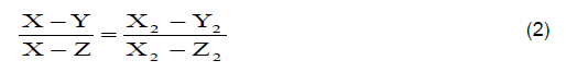
where, X and Z = The upper and lower location of degree latitude (?) from the table; Y = site location found between X and Z degree latitude (?); X2 and Z2 = the standard tabulated value of the corresponding degree latitude (mm d-1) for each month; and Y2 = the calculated value (mm d-1) for each month, that is, Ra value.
Thermal zoning was based on a range of mean daily temperatures during the growing season and closely related altitude ranges using a 500 m contour (Teshome and Verheye, 1994). LUPRD (1984) revealed that the relationship between temperature and altitude for the whole country of Ethiopia (except southeastern parts and the Ogaden) was given by the equation.
T(gp) = 30.2-[0.00059 × Altitude] r2 = 0.90 (3)
Where, T(pg) is the mean temperature during the growing period (°C), altitude in meters above sea level (masl).
Finally, the length of growing period (LGP) was defined by counting the number of days between the start of the growing period and end of rains plus the period required to evapotranspiration the assumed 100 mm moisture stored in the soil reserve (time of soil moisture utilization) during the rainy season. The length of period (in days) required for evapotranspiration of the assumed 100 mm water stored in the soil at full rates of evapotranspiration was computed using the simple water balance (SWB) method, which is the difference between rainfall (RF) and reference evapotranspiration (SWB = RF-ETo). The computation of the water storage began with the first month of humid season (RF > ETo) as indicated in FAO (1983) and Sys et al. (1991a).
Characterization of soil and landscape
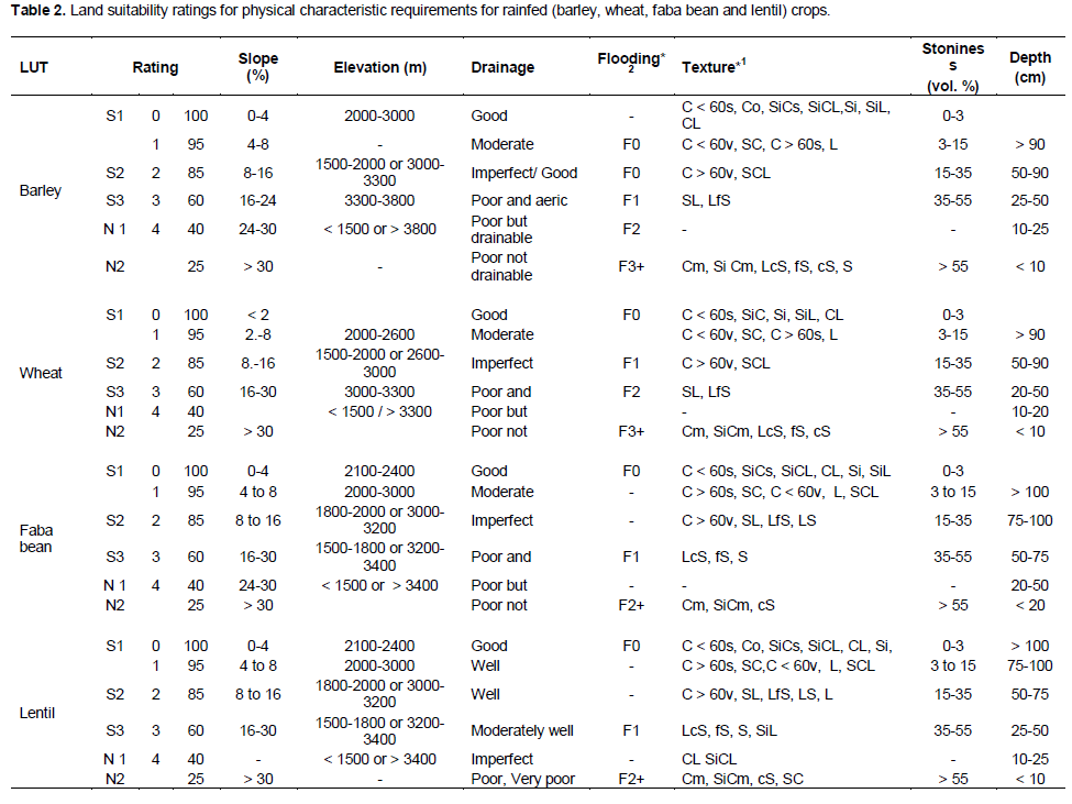
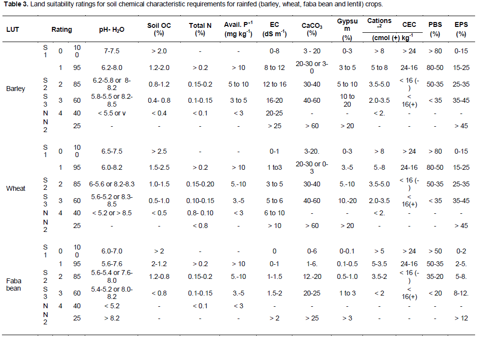
For soil and landscape evaluation topography (t), wetness (w), physical characteristics (s), fertility characteristics (f) and salinity and alkalinity (n) were considered (Table 4). The main focus of the study was on cultivated lands. Since the land suitability evaluation in the study area was for annual crops of T. aestivum L, H. vulgare L., V. faba L.and L. culinaris L., and the reference depth of 100 cm was used. The soil horizons had different textural classes that were calculated for the depth of the rooting zone for the representative pedons using equal sections and weighting factors. Weighted average of the upper 25 cm was used for the evaluation of soil pH, soil OM, total nitrogen, available phosphorus and sum of basic cations, and apparent CEC in the B horizon at a depth of 50 cm was calculated (Sys et al., 1991b, 1993).
The soils were characterized by opening pedons at representative sites on the identified mapping units and soil samples were collected from generic horizons and analyzed following the WRB (2006) guideline. The description of landscape characteristics were recorded during the pedon site characterization and the relevant soil properties were determined in the laboratory following standard procedures and analytical methods for each parameter. These soil data were used for evaluating the soil and landscape suitability for the specified crops (Table 4).
Land suitability evaluation (matching) and production of suitability maps
To delineate the watershed and land mapping units with different GIS input data (thematic layers), topographic map, topo map sheet, shuttle radar topography mission (SRTM) image, satellite image and digital elevation model (DEM) were used. The DEM were derived from the SRTM image which generates slope, flow accumulation and drainage network by using ArcGIS 10.2. The land unit map was used as a guide in the field survey and soil sampling. In turn, more detailed soil maps were developed following the reinterpretation of field observation and soil analysis. The global positioning system (GPS) data were used for geo-referencing of the soil pedons. Finally, the land suitability classification was done according to the FAO (1976, 1983) methods and the land suitability maps were produced for the production of the suitability mapping units for the selected land utilization types.
Description and characterization of land mapping units
Land mapping unit 1Ac
This LMU contains Pedons LG05, LC06 and LC07. They have been characterized by very gently sloping with slope of (1 to 2%), altitude ranges from 2800 to 2900 masl, basaltic parent materials, very deep soil depth (> 150 cm), area coverage 20.6%, poorly drained, color ranges from dark grayish brown (10YR 4/2) to very dark grayish brown (10YR 3/2) when dry and from very dark brown (10YR 2/2) to black (10YR 2.5/1) when moist; heavy clayey soils with high shrink and swell potential that would have wide and deep cracks when dry, high gilgai micro relief, common distinct slicken sides, very strong medium prismatic structure, hard to very hard (dry), firm (moist); very sticky and very plastic (wet) consistency; no excessive compaction and restriction of root development, abrupt and wavy boundary.
The LMU has slightly acidic to slightly alkaline in pH-H2O (6.9-7.6) and non saline soils (EC < 0.5 dS m-1), low in organic matter (1.66 to 1.97%) and total nitrogen (0.08 to 0.10%) contents, medium in available phosphours (10.26 to 13.25 mg kg-1), high to very high in exchangeable Ca (21.09 to 26.25 cmol (+) kg-1) and Mg (7.45 to 8.20 cmol (+) kg-1) and moderate in monovalent cations (Na and K), high to very high in CEC (37.49 to 45.89 cmol (+) kg-1) and PBS (82.15 to 89.86%). The extractable micronutrients (Fe, Mn, Cu and Zn) were also having high values of nutrient contents.
Land mapping unit 2Ac
This unit refers to soil Pedons MG01, MC02 and MG08 which have gently undulating with slope (2-4%), very deep soil depth (> 150 cm), altitude ranges from 2900-3000 masl, basaltic parent materials, color ranges from dark gray (10YR 4/1) to dark grayish brown (10YR 4/2) in dry and from very dark grayish brown (10YR 2.5/2) to bluish black (10YR 2.5/1) in moist, clay to heavy clayey soils with high shrink and swell potential that would have wide and deep cracks when dry, common distinct slickensides, high gilgai microrelief, area coverage 44.6%, poor drained, few boulders sub rounded slightly weathered quartz nature of rocks, strong medium prismatic structure, hard to very hard (dry), firm (moist), sticky to very sticky and plastic to very plastic (wet) consistency, abrupt and smooth boundary.
The mapping unit has slightly acidic to neutral in pH-H2O (6.6-7.03), non saline soil (EC < 0.5 dS m-1), medium in OM (1.99-2.83%) content, very low to medium in total N (0.01-0.16%), low to medium in available phosphorous (7.24-14.43 mg kg-1), high to very high exchangeable Ca (23.22-26.90 cmol (+) kg-1) and Mg (6.58-7.86 cmol (+) kg-1) and moderate in monovalent cations (Na and K), high to very high in CEC (35.17-44.79 cmol (+) kg-1) and PBS (86.10-90.76%). In the exchange sites, the divalent (Ca and Mg) cations were dominant than the monovalent (Na and K) cations in the study area. All the extractable micronutrients (Fe, Mn, Cu and Zn) have high values above the critical levels.
Land mapping unit 2Bc
This LMU contains with Pedons UC03 and UC09 which is slopping with slope of 5 to 8%, altitude ranges from 3000 to 3100 masl, moderately well drained, area coverage 8.6%, moderately deep (50 to 100 cm), color ranges from brown (10YR 4/3) to dark gray (10YR 4/1) in dry and dark brown (10YR 3/3) to very dark gray (10YR 3/1) in moist, clay in texture with shrink and swell that would have moderately wide and deep cracks when dry, some gilgai microrelief, strong coarse granular structure, slightly hard to hard (dry), firm (moist), sticky and plastic, abrupt and smooth boundary.
The LMU 2Bc was slightly acidic to alkaline in pH-H2O (6.9 to 7.5) and non saline soils (EC < 0.5 dS m-1), low to high contents of CaCO3 (3.34 to 13.22%), low in soil OM (1.58 to 2.11%) and low to medium in total N (0.09 to 0.14%) contents, medium consents of available phosphorous (9.26 to 10.49 mg kg-1), high to very high continents of exchangeable Ca (19.98 to 27.58 cmol (+) kg-1) and Mg (6.90 to 7.91 cmol (+) kg-1) and moderate in monovalent cations (Na and K), high to very high in CEC (38.51 to 53.20 cmol (+) kg-1) and PBS (74.10 to 86.73%). The extractable micronutrients (Fe, Mn, Cu and Zn) were high that would have above the critical ranges.
Land mapping unit 3Ccl
This LMU refers to soil Pedons UC04 and UC10 which is steeply dissected topography with slope of 8 to 16%, altitude ranges from 3100 to 3300 masl, 15.04% of area coverage, shallow to moderate soil depth (50 to 100 cm), well-drained soil, soil color ranged from dark brown (7.5YR 3/2) to dark gray (10YR 4/1) in dry and from very dark brown (10YR 2/2) to very dark gray (10YR 3/1) in moist, clay loam texture, no excessive compaction and restriction of root development, moderate to strong medium granular structure, hard (dry), friable to firm (moist), slightly sticky to sticky and slightly plastic to plastic (wet) consistency, many very coarse high plane pores, abrupt and smooth boundary.
The LMU 3Ccl was slightly acidic to neutral in pH-H2O (6.5 to 7.1), non saline soil (EC < 0.5 dS m-1), low in OM (1.57 to 2.40%) and total N (0.08 to 0.12%) contents, low to medium available phosphorous (6.8 to 10.38 mg kg-1), high to very high in exchangeable Ca (21.54 to 28.97 cmol (+) kg-1) and Mg (7.69 to 8.86 cmol (+) kg-1), and moderate in monovalent cations (Na and K), very high in CEC (44.14 to 56.5 cmol (+) kg-1), high to very high in PBS (60.22 to 89.92%) and high status of micronutrients (Fe, Mn, Cu and Zn).
Land mapping unit 4Dcl
The LMU 4Dcl refers to soil Pedon UC12 which is steeply dissected topography with the slope of > 16%, shallow soil depth (< 50 cm), high elevation with 3300 to 3450 masl, area coverage 11.3%, well-drained soil, color ranged from dark grayish brown (2.5Y 4/2) to light reddish brown (2.5YR 6/4) in dry and from reddish brown (2.5YR 5/4) to dark reddish gray (5YR 4/2) in moist, clay loam texture, no excessive compaction and restriction of root development, many boulders sub rounded slightly weathered quartz nature of rocks, moderate fine crumb to strong medium prismatic structure, slightly hard to hard (dry), friable to firm (moist), sticky and plastic (wet) consistency, common medium plane pores and abrupt and smooth boundary.
The LMU 4Dcl has slightly acidic to neutral in pH-H2O (6.8 to 7.01), non saline soil (EC< 0.5 dS m-1), low in OM (1.74 to 2.42%) and low to medium in total N (0.09 to 0.14%) contents, low to medium in available phosphorous (7.77 to 11.13 mg kg-1), high to very high in exchangeable Ca (21.69 to 21.88 cmol (+) kg-1) and Mg (7.02 to 7.98 cmol (+) kg-1) and moderate in monovalent cations (Na and K), very high in CEC (45.84 to 47.20 cmol (+) kg-1), high in PBS (65.53 to 79.97%) and high status of micronutrients (Fe, Mn, Cu and Zn).
Agro-climatic analysis and suitability evaluation
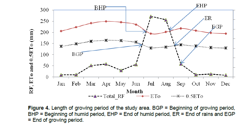
The Wadla Delanta Massif followed the normal growing periods that agree with FAO procedure which reveals that the humid period (precipitation exceeding the potential evapotranspiration) and the beginning of the growing period was derived from the start of the rainy season. The average reference evapotranspiration (ETo) of the areas was estimated to be 106.5 mm/month (3.5 mm/day). The mean calculated value of the LGP, in the study area, is 133 days (Figure 4).
The beginning of growing period (BGP) in the study area starts on June 11 (2nd decade) and the humid period (BHP) on June 20 (2rd decade), ends of humid period (EHP) on September 9 (1st decade) and the rain season ends on September 20 (2nd decade). The daily evapotranspiration in September is 3.35 mm/day and the daily evaporation rate for 30 days were required to utilize 100 mm water and generate end of growing period on October 21 (3nd decade). The growing period curve of the study area is presented in Figure 4.
The period launched from the start of growing period to the end of rain which covers around 102 days using the indicated model (Hargreaves-Samani, 1985). Moreover, it required additional number of days intended for evapotranspiration - the assumed 100 mm of water expected to be stored within the soil at the end of rain. Therefore, the LGP is extend up to October 21st (3rd decade), which is a total of 133 days required. This showed that all the selected principal crops with the maximum crop cycle of 133 days can fit into the growing period or can be grown using rainfed agriculture of the study area.
The results of the overall climatic suitability evaluation showed that the agro-climatic situation of the study area is marginally suitable (S3) for selected varieties of T. aestivum L. and V. faba L. and L. culinaris L. whereas it is moderately suitable (S2) for H. vulgare L., variety (Table 5 and Appendix Table 1). All the considered varieties are practiced under rainfed conditions. The main limiting factor is the occurrence of frost hazard that appears in three months from October to December. Therefore, the famers might practice early or late sowing dates and choose relative varieties of frost resistance crops.
Soil and landscape suitability evaluation for agricultural field crops
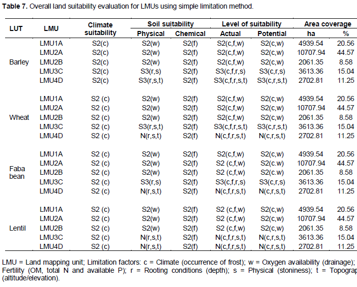
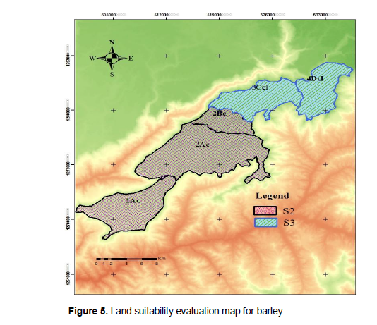
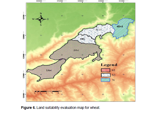
The results of the ultimate soil and landscape suitability evaluation showed that LMU 1 and 2 are moderately suitable (S2) for all considered crops and having limitations of erosion (e) and wetness (w), whereas LMU 3 is moderately suitable (S2) for barley, marginally suitable (S3) for wheat and faba bean and not suitable (N) for lentil. The main limiting factors are altitude, erosion and surface stoniness. Land mapping unit four was marginally suitable (S3) for H. vulgare L. and not suitable (N) for all other selected. The main limiting factors are soil depth, high altitude, erosion, surface stoniness and nutrient deficiencies (Tables 4, 6 and Appendix Tables 2 and 3).
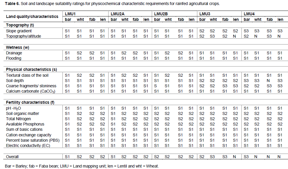
Most of the land characteristics considered in the evaluation, lands currently under rainfed cultivation, range from suitable to moderately suitable for agricultural purposes. As compared to the middle and lower topography, the upper topography soils were found to be well drained, low depths and rocky. On the other hand, some of the middle and all of the lower topographic soils showed that high depth, poorly drained and high water logging condition. Occurrence of frost is the common problem in all topographic positions. The textural classes ranged from clay loam to heavy clayey. The evaluation class for the crops’ suitability ranges from moderately suitable (S2) to permanently not suitable (N). This is due to the different condition that the crops require for their developments in the local area in question (Table 7 and Appendix Tables 1 to 3).
Overall suitability evaluation
The majority of the cultivated land, about 65.13%, is classified as moderately suitable for all considered field crops. As concerning for T. aestivum L. and V. faba L. crops, about 15.04 is marginally suitable and 8.5% not suitable. For H. vulgare L. 80.2% is moderately suitable and 8.5% as marginally suitable, and for L. culinaris L. crop, about 23.5% of the land is not suitable. The main limiting factors are altitude, soil depth, erosion and surface stoniness. The results of the analysis provided in Table 7 and Figures 5, 6, 7 and 8).
Source: Adapted from FAO (1976, 1983), FAO/UNDP (1984), Sys et al. (1991, 1993); Teshome and Verehye (1994). (*) Textural range: Cm = massive clay; SiCm = massive silty clay; C+60,v = fine clay, vertical structure; C+60,s = fine clay, blocky structure; C-60,v = clay, vertical structure; C-60,s = clay, blocky structure; SiCs = silty clay, blocky structure; SiCL = silty clay loam; CL = clay loam; Si = silt; SiL = silt loam; SL = sandy loam; L = loam; SCL = sandy clay loam; SL = sandy loam; Lfs = loamy fine sand; LS = loamy sand; LcS = loamy coarse sand; fS = fine sand; S = sand; cS = coarse sand; Co = clay, oxisol structure.