ABSTRACT
Ethiopia is constantly affected by shortage of water for rain-fed agriculture, mainly because of lack of proper water resources utilization and management practices. For the efficient use of available surface water resources with balanced attention to maximize economic, social, and environmental benefits, it is necessary to have effective integrated water resources assessments and planning. Beles River Basin is one of the most potential river basins in Ethiopia, which is the main tributary for upper Blue Nile River Basin and accounting 14,200 km2. In order to supplement planning and development of this area, a detailed characterization of the basin is important. The main objective of this study is to process and determine different terrain processing parameters and morphology by using Arc-Hydro tools in Arc-GIS for generating different data for the basin. Therefore, it has been observed from this study that the drainage density is higher in relatively elevated areas especially when the weathered section is thick or when the pattern of structures crossing the rocks is higher. Direction of flow of these rivers is controlled by the topography. The highlands (maximum 2729 m above sea level) from where the streams flow are general humid and rugged and the surrounding lowlands (minimum 458 m above sea level) in which the streams flow, are mostly arid and relatively flat. These topographic differences induce rapid run off, low retention in soil layers and soil erosion on the highlands. Considering a 30 × 30 m drainage area, 62 catchments, eight flow directions with 128 flow grids have been identified in the basin. The delineated watersheds were Gilgel Beles with 617.56 km2, Upper Main Beles with 2866.05 km2 and Lower Main Beles with 6613.84 km2. Therefore, the watershed external boundary is determined to be 10,097.45 km2. Important basin information, like slope and contour lines has been determined through spatial analysis and the result indicated that about 52.8 % of slope was found to be relatively suitable for agricultural soil and water management options in Beles River Basin. In the future, it would be advisable to consider emerging issues in water resource measures like GIS modeling with Remote Sensing data for effective and efficient water resource management when there is limited and lack of data.
Key words: River basin, Arc-Hydro, Arc-GIS, Degital Elevation Model (DEM).
It is well known that water is life; now a day’s different report shows that water is also a means livelihood. It is the route to come out of poverty for individuals and communities. Managing water is essential if the world is to achieve sustainable development (Cosgrove, 2006). This challenge is even more pressing as the world confronts the triple threats of climate change, rising food and energy costs, and the global economic crisis. All three are exacerbating poverty, inequality and underdevelopment (UNWWD, 2006; FAO, 2010). Hence, in many places of the world, there is competition for water resources because the population is increasing every day this means a major production of foods depends on the judicioisex3 and consumption of the available water resources (Abbadi and Nitin, 2011). Besides, the distribution of water is very irregular in space and time. This challenge needs the use of different tools that allow professionals and specialists to plan for improving the use of water resources effectively and efficiently in their respective regions (Tesfaye and Kemal, 1989). One of the most important tools that can be used to that end is Geographic Information Systems (GIS). It is a system with different features which enables to analyze and store as spatial information for being used later with other models of water resources. Besides there are many databases which are available on internet such as climate variability, soil, land use/land cover, gauging stations, and these can be processed in geographical information system GIS (Jasrotia et al., 2009). It is playing a great role by being used as an important tool for hydrological modeling, and it processes Digital Elevation Model (DEM) to delineate watersheds and stream network (Maidment, 2002). In that sense, hydrologists use several data sources to evaluate water quality, quantify water allocation, avoid flooding, plan and operate water resources systems, and interpret environmental problems. Likewise, experts or specialists and people involved in water resources who use GIS as a tool and as a database are increasing dramatically though out the world. Therefore, GIS today is being accepted as a powerful tool for storing spatial information around the globe (Walker and Zhang, 2001).
The overall objective of this study was to characterize and determine different terrain processing parameters and morphology, by using Arc-Hydro tools in Arc-GIS for generating different data for Beles River Basin. The specific objectives are: (1) determine and identify streams and drainage lines, (2) classify watershed and sub-watersheds and determine their respective areas, and (3) generate information of the basin for water resource and river basin management.
Study area
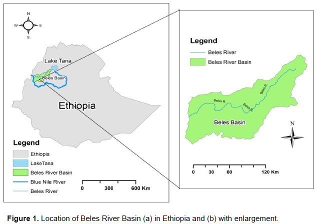
This study focuses on the Beles River Basin, it is situated on the plateau of the north-western highlands and its adjacent lowlands of Ethiopia, in the southwestern direction of Lake Tana between 10° 56’ to 12° North latitude and 35°12’ to 37° East longitude. The total area of the basin is about 14,200 km2. The topography of the area is mainly flat with altitudes variables from 458 to 2729 m above sea level. Beles is one of the most important basins in Ethiopia and one of the major sub-basins of Upper Blue Nile Basin (Figure 1).
Data sources and processing
The data source for this study, that is, ASTER Global DEM (GDEM) from the Ministry of Economy, Trade and Industry of Japan (METI) and the National Aeronautics and Space Administration (NASA) are collaborating on the project in order to develop ASTER Global Digital Elevation Model (ASTER GDEM), DEM data which are acquired by means of a satellite-borne sensor, so-called "ASTER", to cover all the surfaces of the earth (http://Earthexplorer.usgs.gov) carried out with a resolution of 1 arc second (30 × 30 m of position) digital elevation raster which covers almost the entire globe. These facilities allowed to download a DEM data for the study area in which four tiles having 170/52, 170/53, 171/52 and 171/53 path/row was first rectified, corrected and geo-referenced to the UTM (WSG-1984 UTM-37N) projection system. Before processing DEM, a buffer of the study area has been used to create a mask. Using DEM as input raster, all information of the area was extracted by masking and feature mask data was the Beles buffer (Figure 2).
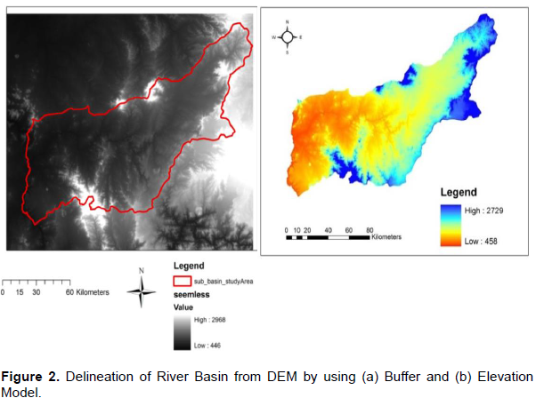
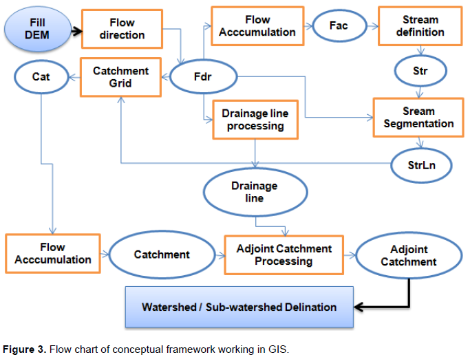
Mosaic (Arc-GIS 9.3) standard DEM of four different tiles in one new raster by using Arc-Tool box and also processing seemless raster mosaic since it is necessary to fit the tiles together and for better visualization of mosaic image. The coordinate system was converted from geographic systems to a projected geographic system, by using Arc Tool box (Data Management Tools, projections and transformations, raster, project raster) in Arc-Map. Universe Transverse Mercator (UTM) was selected because it is a coordinate system that is more adaptable to the study area, and then extraction through spatial masking to clip processed DEM data to Beles River Basin (Figure 3).
Terrain data processing
A terrain data processing has been started with the identification of drainage and catchment patterns through DEM which was mainly used to prepare the spatial information of the Beles River Basin for the subsequent use. The Digital Elevation Model was processed using Arc-Hydro Tools 9 in Arc-Map, because the application of this tool allowed generation of information of flow direction, flow accumulation, stream definition, stream segmentation, drainage lines, and watershed delineation for the Beles River Basin (USACE, 2010).
Once the area was specified, DEM reconditioning is necessary to consider unclear flow direction which occurred by any surface alteration. This technique allowed the adjustment of the surface of elevation of the DEM to be consistent with vector coverage.Therefore,it helped to find cells in a DEM with low elevation enclosed by other cells with high elevation. These low cells, so called “sinks”, may be formed by the landscape features or errors during the DEM generation as well as by the limited resolution of the Digital Elevation Model. The sink is filled until it will drain the water to the next lowest point by using “fill sink” tool in Arc Hydro with Arc Map interface (Maidment, 2002).
Flow direction and accumulation
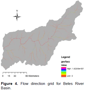
The flow direction for the Beles River Basin was determined for the filled DEM, which is one of the most important for generating the hydrologic characteristics of the river basin. In Arc Map, the flow direction function calculates the direction of the flow out finding the direction of the steepest descent from each cell in the grid. There are eight output directions in which the flow of a cell can move in the basin (Figure 4).
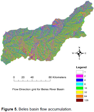
The flow accumulation for the Beles River Basin was calculated taking as base the flow direction (Figure 5). Its procedure consisted of calculating the accumulated flow for each cell as the weight of each of them which flows through down slope. Therefore, the output of the flow accumulation represents the amount of water which would flow through each cell and it is also used as a base to create the drainage lines.
Stream definition and segmentation
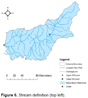
The streams definition for the Beles River Basin was made considering the default threshold for cells of 30 × 30 m. It was to identify the threshold drainage area used to generate a stream in the study basin. After the definition of streams, a grid of stream segments was created by using the “stream segmentation” function in Arc Hydro Tool. In Figure 6, the detailed stream definition for the basin of study is shown.
Catchment grid delineation and polygon
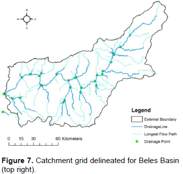
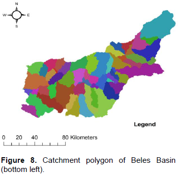
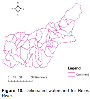
Catchment grid delineation in Arc Map allowed creating a grid for segment in the stream link grid (stream segmentation). These functions allowed converting the raster data into a vector format. Catchment polygons were created from the catchment grids, and by converting the stream link grid into a drainage line feature created by drainage lines. For Beles River Basin, 62 catchments were created and also a drainage line belongs for each of them. Moreover, this method could allow us to identify the drainage areas into each stream link as shown Figures 7 and 8.
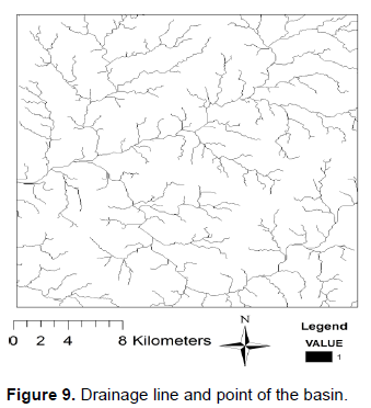
Drainage line, and drainage point processing
These functions are allowed to convert the raster data into a vector format. Catchment polygons were created from the catchment grids, and by converting the stream link grid into a drainage line feature created by drainage lines. For Beles River Basin, 62 catchments were created and also a drainage line belongs to each of them. The catchment polygon, drainage line processing and drainage points generated are as shown in Figures 9 and 10.
Watershed processing
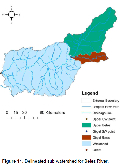
In watershed processing delineation of the watershed and sub-watersheds as well as determination of the flow path in the river basin have been done. Arc Hydro in Arc Map was used to carry out this process. In this part, a bath point was created in the outlet of the basin in order to delineate it. After that, the sub-watersheds are delineated by using the sub-menu batch sub-watershed delineation.
Batch watershed delineation
The drainage lines, accumulated flow, flow lines and the preliminary delimitation of the river basin fundamentally have delineated the watershed. Firstly, outlet point was created on the flow accumulation path where the flow leaves the Beles River Basin which in this case, the point is where exactly Beles River meets the Blue Nile at the extreme bottom of the catchment of the basin since it is one of the tributary of Blue Nile. For this end, the “Batch Point Generation” button in Arc Hydro was used. This point can be used as an input for using the “batch watershed” and “sub watershed delineation” functions. The drainage area of the delineated watershed is 10,097.45 km2.
Batch sub-watershed delineation
The sub-watersheds are divisions based upon the drainage area, divided by a watershed. In this part, sub watershed was created for every point in the bath point feature class; and the result was stored in a sub-watershed feature class. Therefore, sub watersheds were delineated by considering three very important points in the river basin. Two of them are located on higher ground of the basin through which the major amount water resources drain from those sub watersheds. Another point is located in the outlet of the Beles River Basin, and it defines the sub watershed in the lowest altitude. Once the watersheds have been defined, they were used as measurement areas to calculate different parameters. The drainage areas cover surfaces of 6613.84, 2866.05, and 617.56 km2 for the sub watershed Lower Main Beles-Outlet, Upper Main Beles, and Gilgel Beles, respectively. The results of the delineation of the sub-watershed are as shown in Figure 11.
Spatial analysis
Slope and contour lines
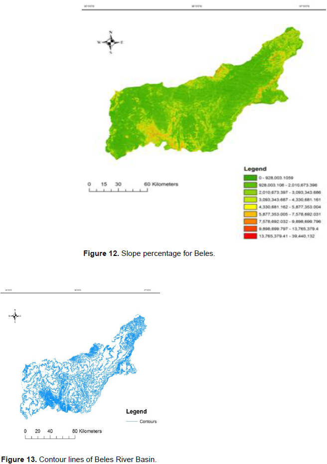
The slopes and contour lines were calculated with “Spatial Analyst” tool in Arc GIS by using Beles-DEM as input, then slopes and contour lines were calculated as output. The mean slope calculated for Beles watershed was 3%. With regard to the sub watersheds, the values of mean slope were 3.8, 1.9, and 3.3% for upper main Beles, Lower Main Beles and Gilgel Beles, respectively. The result showed that 41.3% of the basin was less than 3% of slope, 11.5% of the basin was from 3 to 5% of slope, 19.4% from 5 to 9% of slope and 27.8% of the basin slope was greater than 9%. Therefore, with regard to the mean slope calculated for the watershed and sub-watersheds, the values were higher for the Upper Main Beles, indicating that this area where the stream lines start to drain down the watershed is at higher elevation. The input surface was the Beles DEM with a contour line distance of 50 m interval (Figures 12 and 13).
The conclusions of this work are summarized in the following paragraphs.
Delineating and organizing data for river basins, like Beles River Basin for which where information and databases are not available, by using an “Arc-Hydro” in Arc-Map which is powerful as well as a decision supporting tool. So, this project shows the possibility of using information available on the internet and processing it with “Arc-Hydro” tool, in order to generate and store data which will contribute finally to improve the operation and planning of the water resources systems in the Beles River Basin.
The drainage density was higher relatively in elevated areas especially when the weathered section is thick or when the pattern of structures crossing the rocks was higher. Direction of flow of the river was controlled by the topography. The highlands, from where the streams flow, are in general humid and rugged and the surrounding lowlands, into which the streams flow, was mostly arid and relatively flat. These topographic differences induced a rapid run off, low retention in soil layers and soil erosion on the highlands.
The delineated watersheds were Gilgel Beles with 617.56 km2, Upper Main Beles with 2866.05 km2, and Lower Main Beles with 6613.84 km2. Therefore, the watershed external boundary is determined to be 10,097.45 km2. The sub-watersheds of Upper and Lower Beles River are the main source of water resources in the basin which may be related to their area and the mean annual rainfall recorded in the respective sub-basin.
From the spatial analysis, important basin information, like slopes and contour lines, has been determined and the result indicated that about 52.8% of slope was found to be relatively suitable in agricultural soil and water management options in Beles River Basin.
The author has not declared any conflict of interests.
REFERENCES
|
Abbadi GR, Nitin KT (2011). Mainstreaming Climate Change Adaptation in Urban Planning in Africa. In USMCA 2011 International Symposium, Thailand.
|
|
|
|
Cosgrove WJ (2006). Water for Growth and Security. In Water Crisis: Myth or Reality? Marcelino Botin Water Forum 2004Peter Rogers, M. Ramon Llamas, and Louis Martinez-Cortina, eds. London: Taylor and Francis.
Crossref
|
|
|
|
|
FAO (2010). Climate change threat to Africa: Adaptation a priority. FAO, Rome, Italy.
|
|
|
|
|
Jasrotia AS, Abinash M, Sunil S (2009). Water Balance Approach for Rainwater Harvesting using Remote Sensing and GIS Techniques, Jammu Himalaya, India. Water Resour. Manage. 23:30353055.
Crossref
|
|
|
|
|
Maidment DR (2002). Arc Hydro-GIS for Water Resources, ESRI Press, Redlands, California 220 p.
|
|
|
|
|
Tesfaye G, Kemal Z (1989). Water Resources Development Projects and their environmental impact in the Ethiopian setting. In: Government of Democratic Republic of Ethiopia, 1990, National conservation strategy conference Document, Ethiopia's Experience in conservation and Development. 3:53-512 ONCCP, Addis Ababa, Ethiopia.
|
|
|
|
|
UNWWD (United Nations World Water Development) (2006). Report 3, Water in Challenging. Istanbul, Turkey. UNESCO publishing.
|
|
|
|
|
US Army Corps of Engineers (USACE) Institute of water resource, (2010). Hydrological Modeling System HEC-HMS, User's manual. Hydrological Engineering Center, Davis, CA.
|
|
|
|
|
Walker GR, Zhang L (2001). Plot-scale models and their application to recharge studies. In: Zhang L, Walker GR, ends, Studies in Catchment Hydrology: the basics of recharge and discharge. Melbourne, CSIRO Publishing.
|
|