ABSTRACT
The purpose of this study is to investigate the opinions of teachers and preservice teachers of social studies on geo-literacy. The study used the qualitative research design of phenomenology to collect data. The study consisted of 20 teachers and 30 prospective teachers of social studies. The purposive sampling method of criterion sampling was taken as a basis. Descriptive analysis method was used to analyze the data obtained via interviews. As a result of the study, most preservice teachers of social studies defined geo-literacy as having geographical knowledge, as well as reading and interpreting geographical information; while social studies teachers define it as making sense of interpreting geographical information. When the opinions of preservice teachers of social studies on their efficacy levels were asked, they stated that they knew about geographical information- conceptual information on an intermediate level, they also stated that they did not find themselves capable in spatial perception skills, association, relation, and critical geography dimensions. Regarding the problems experienced in geo-literacy, teachers and preservice teachers of social studies stated that trips-observations are not included, abstract information is not materilalized, concepts are not completely explained, skills of spatial perception and practive levels are not sufficiently included. Despite the high number of targeted outcomes in the curriculum, class hours is a limitation, and teachers are not sufficiently knowledgeable about geo-literacy.
Key words: Geo-literacy, social studies, social studies teacher, social studies preservice teacher.
Geography is the science of investigating the distribution of natural, human and economic activities on the entirety of the earth or a part of it, the relationships among these and causalities (Özey, 2002). DoÄŸanay (2011) defined geography as the science that investigated the natural, human and economic environment factors of the earth by association with humans. As seen here, geography necessitates not only the understanding of the world, but also making sense of it and associates it with humankind. In geography instruction, the fundamental principle is to train individuals who have geographical inquiry skills with a comprehension of geographical information. In geography, the expection is not only that the individual is aware of the space around them, but also, they have the awareness of being responsible in all geographical interactions all over the world and have an awareness of creating solutions (Öztürk, 2008). The main purpose of the science of geography is to have students understand the world they are living in. Goals of geography include achieving sustainable development, playing a role in the establishment of development plans, creating patriotism, raising awareness for the environment and natural disasters, facilitating comprehensive look at events, understanding the world and respecting different cultures, providing individuals with not only information but also skills, values and attitudes, and putting these into practice in their daily and professional experiences (Aydın and Güngordü, 2015). While reaching these goal, geography utilizes the principles of distribution, causality and relationship (DoÄŸanay, 2011). Frequently used instruction principles regarding geography teaching are learner-oriented teaching, proximodistal, from known to unknown, from abstract to material, clarity, comprehensiveness, actuality and economicality (Ünlü, 2014).
The power and beauty of geography allow one to see, understand and interpret the network of relationships among people, places and envirionments. Analysis of differences and similarities in space and different geographical appearances contributes to comprehension of the earth as the residence of humans and therefore better utilization of it. The roots of and solutions to various domestic and international economic or political problems depend highly on geography (Aydın and Güngordü, 2015).
In order to ask geographical questions in making national and international decisions, training people who are aware of global developments, achieving sustainable development both in daily life and in the scientific sense and raising geographical awareness, geographical information is needed. Geographical information is significant due to its relationship with the problems of the world we live in. This information improves the critical thinking skills of students by teaching them how to read maps and interpret information on local and global scales. Therefore, it helps students understand the world. Thus, in order to have skills of geographical thinking and shape human life, geography should be the center of life. This is only possible by provision of a qualified training of geography (Åžahin, 2003).
Geography training changes the current development of children in terms of geography, their sense of space, awareness of the world, attitudes and values. It increases their experiences about the world. It informs children about places and environments, and develops questions and skills that require children to inquire about the local and global envirionment (Catling, 2015).
Geography is not a discipline of general knowledge that only provides general knowledge and helps enlightened individuals comprehend the systematique of event in the world. In addition to these function, it is also effective in development of patriotism in individuals. Loving, defending and managing a place where one lives, require a good geography education. This means, geography education is a mutual necessity for everyone and every part of the society (Meydan, 2011). The interaction of the humankind with the natural envirionment has gained a different dimension today in comparison with the past. The humankind pays more attention on developments in the world, and wants to have more information on the events taking place in the world. Awareness and knowledge of humans on events in the world will be possible by an effective geography education and training (Åžahin, 2010).
It is not sufficient to only have information in geography education. Usage of this information requires being geo-literate. Welton (1988) described geo-literacy by combining three main elements as knowledge of the physical environment, map usage skills and knowledge of the main concepts of geography. In the cultural and functional sense, geo-literacy goes further by having the location information of places, and it may be described as having talents that contain basic map skills and skills oriented around human-environment relationship (Gençtürk, 2009). Geo-literacy is also defined as learning, making sense of and deciding on the main information, concepts and processes regarding geography, and using these (Tuna, 2013), and as the skill to understand and comprehend various types of geographical information and turn them into skills (Dikmenli, 2013).
Different scientific schools of thought determined some principles in terms of geo-literacy. Education National Geographic divided geo-literacy into three titles: “interaction, connection and effects”. They stated that geo-literacy mainly requires three things, and these are interaction, interconnections and inferences (Edelson, 2012).
Geo-literacy progresses on three different levels as lower-intermediate-upper. Lower-lower level geo-literacy covers the skills of knowing names and locations of places that are the fundamentals of geographical information. Intermediate-level geo-literacy covers understanding of the relationship of humanity with the environment with its reasons, and skills of questioning, confirming, examining and analyzing geographical information. Upper-level geo-literacy covers the critical geography approach. This approach requires students to have critical thinking skills and ability to understand the relationship of geography with different natural resources and strengths of nations. For critical geography, the way the strength of places affects the political and economic processes in individuals’ lives is important (Oigara, 2006).
According to Bliss (2005), a geo-literate person understands the reasons for preference of living spaces, why people live in communities, and how the places they live in affect their lives. Geo-literacy provides an approach where social justice is achieved, which aims for a future that is more egalitarian, peaceful and serene (Erol, 2015). According to Nishimoto (2012), geo-literacy covers the decisions we make in solutions for problems we meet in our daily life. It provides individuals with an approach that increases collaboration among people and aims at a future that is egalitarian, peaceful, socially just and serene. Learning about the physical and human systems in the rapidly globalizing world is not sufficient in our time. Geography needs to answer the following questions: Why? and How? Why does technology change? Do developments in transportation systems affect economic activities? Why do political borders change? Does this change affect neighbor countries? Geo-literacy allows students to conduct analyses and syntheses on such issues (Erol, 2014).
In a society with high geo-literacy levels, people reach richness and good quality of life, and they also become qualified individuals who have awareness of national and international responsibilities. In addition to this, individuals act responsibly against economic and social values, while it is emphasized that geo-literacy has a significant role in developments of the national identities of individuals (Yildirim, 2016). The geographical skills to teach geography and help development of geographical teaching in students may be listed as: skills of asking geographical questions, gaining geographical information, organizing and analyzing this information, and responding to geographical questions (Demirkaya, 2003).
Geography education and geo-literacy are also important in terms of the subject of social studies. Social studies teaching is an education program that uses information and methods derived from social studies and humanities in order to train capable individuals who make decisions based on information in the changing conditions of their country and the world and are able to solve problems (Öztürk, 2007). The course of social studies is a multidisciplinary one, therefore, it has areas of learning in geography. 3 of the 9 learning areas in the Social Studies Curriculum are directly or indirectly related to geography. The learning areas are people, places and environments; production, distribution and consumption; glocal connections. The geography units in the 4th-7th grade geography curricula are: Where We Live; Let Us Know Our Region; Life on Earth; Population of Our Country; From Production to Consumption; What We Produce; Resources of Our Country; Economy and Social Life; My Friends That Are Far Away; The World That Belongs to All of Us; Our Country and the World; Bridges between Countries. Two of the six skills regarding social studies are directly related to topics of geography. These are skills of observation and spatial perception. Additionally, other skills students are expected to gain via geography topics are usage of atlases, perception of time, reading maps, and reading and preparing charts (MEB, 2005).
Standards were developed for teachers of social studies regarding their field. The geographical capabilities of teachers of social studies are the following: They should lead students to use mind maps to organize their knowledge about people, places and environments in the spatial context. They should help students understand the physical and human characteristics of places. They should help students develop their conception of area in order for them to understand and interpret the complex structure of the world. They should lead students to understand how different cultures and experiences affect people’s perception of place and region. They should help students analyze how physical systems affect human activities (National Council for The Social Studies (NCSS), 2002: 12-23).
Several studies have been conducted to measure geo-literacy (Cross, 1987; Wood et al., 1988; Bein, 1990; Donovan, 1993; Eve et al., 1994; Saarinen and MacCabe, 1995; Kitchin, 2016; Roger, 1997; Thomas, 2001; Nolan, 2002; National Geographic Roper Survey, 2002, 2006; Tuncel, 2002; Winship, 2004; Sievertson, 2005; Oigara, 2006; Gençtürk, 2009; Demirkaya, 2009; Tuna, 2013; Erol, 2014, 2015). These quantitative studies revealed that students, prospective teachers and adults with different levels of education lacked the knowledge and skills they required regarding the physical and human environment. It was also determined that students did not have high levels of cognitive thinking skills. Therefore, it is important to get the opinions of teachers and prospective teachers of social studies on geo-literacy.
Objective
The purpose of the study is to investigate the opinions of teachers and preservice teachers of social studies on geo-literacy. Therefore, answers were sought for the following questions:
What are the opinions of teachers and preservice teachers of social studies on:
1. The definition of geo-literacy and importance of it for the subject of social studies,
2. How to develop geo-literacy,
3. Characteristics that people with geo-literacy need to have,
4. Skills-values to gain in order to become geo-literate and the reasons,
5. Problems experienced with regards to geo-literacy and recommendations,
6. What are the opinions of preservice teachers of social studies on their geo-literacy efficacy levels?
Study model
This study used a qualitative research model to collect data. A qualitative study is defined as a form of study where qualitative data collection methods such as observation, interview and document analysis are used, and a qualitative process is followed towards revealing cases and events in a realistic and comprehensive way in their natural environment (Yildirim and ÅžimÅŸek, 2013). The reason for using qualitative design in this study is that it is suitable for focusing on and understanding the special languages, meanings and concepts formed and used by social studies teacher and preservice teachers regarding the issue of geo-literacy. Therefore, it aimed to join the inner-world of the teachers and determine the meaning of what they experienced for themselves. This allowed obtaining a comprehensive outlook of the study’s context and formation of inferences and patters in this context.
Study design
This study used qualitative research model of phenomenology to analyze the opinions of teachers and preservice teachers of social studies on geo-literacy. Phenomenological studies show methodological, careful and in-depth presentation and description of how people experience some phenomena (Patton, 2014).
Sample
The sample of the study consisted of 20 teachers and 30 preservice teachers of social sciences. The study used the purposive sampling method called criterion sampling. Purposive sampling allows in-depth examination of cases that are considered to be information-rich. In many cases, purposive sampling methods are helpful in discovering and explaining cases (Patton, 2014). The main idea in the method of criterion sampling is studing the cases that correspond to a set of pre-determined criteria. The criteria may be formed by the researcher or a previously prepared list of criteria may be used (Yildirim and ÅžimÅŸek, 2013).
Therefore, the researcher determined the criteria for teachers of social studies as: graduation from a social studies education department (1), graduation from different universities (2) and voluntary participation in the study (3). It was expected that teachers who graduated from different universities would have different opinions, social studies education graduates would approach the issue in terms of social studies education, and volunteers would provide more reliable information. The criteria determined for prospective teachers of social studies were: being enrolled in the 4th year of their study (1) and having taken more than one elective geography course (2). It was expected that preservice teachers who were enrolled in their 4th year and selected more than one elective geography course would be able to make a reliable interpretation on geo-literacy. Table 1 shows the demographic characteristics of the participants.
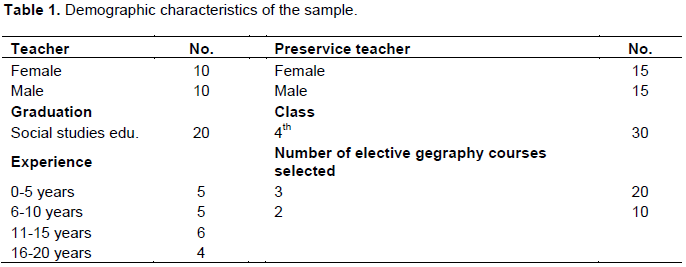
As shown in Table 1, the sample consisted of 15 female and 15 male preservice teachers and 10 female and 10 male teachers of social studies. The teachers of social studies graduated from 10 different universities.
Data collection
The study collected the data with a semi-structured interview form. Using the semi-structure interview form, the opinions of the teachers of social studies on social participation were determined. Interview is a significant method for revealing the perspectives, experiences, feelings and perceptions of people (Yildirim and ÅžimÅŸek, 2004). Semi-structured interviews make participants to describe the world they perceive by their own opinions (Merriam, 2013).
The relevant literature was utilized while forming the questions in the semi-structured interview form. When preparing the interview form, careful consideration was given to the principles of forming the questions so that they can be easily understood, asking open-ended questions, avoiding directing the person, asking questions with a broad scope, and organizing the questions reasonably. Social studies eduation (1), geography education (1), measurement evaluation (1) experts examined the interview form questions to determine whether they are sufficient in supporting each other and reaching the required information. The interview form prepared for the study consists of two sections that contain questions regarding personal information and the topic of the study.
The questions took their final form based on the feedback received from the experts. Preliminary implementation was made with 2 teachers and 3 preservice teachers of social studies. With the positive outcome from the implementation, the interview form took its final shape and the main implementation was started. The interview form contains 6 questions. These questions were prepared based on sub-problems. The teachers answered the open-ended questions in the interview form in half an hour in the teachers’ lounge. Clarifications were made when questions were not understood. Social studies candidate teachers determined according to the criterion sampling were interviewed in the faculty meeting room outside academic hours. Information about the study was given, and explanations were made. Interview form was filled within 25 and 40 min.
Data analysis
Descriptive analysis method was used to analyze the data obtained by the means of interviews. Descriptive analysis allows the data to be organized according to the themes revealed by the research questions and to be presented with consideration of the questions and dimensions used in the interview. In this type of analysis, the purpose is to present the obtained findings to the reader in an organized and interpreted way. The data obtained with this purpose are firstly described in a logical way, and then, causality relationships are reached by interpretation (Miles and Huberman, 1994; Yıldırım and Şimşek, 2013). Within this scope, the answers given to the questions were examined and various categories were created. The answers to each question were compared after coding within the context of the categories was performed. A study on the inter-rater reliability was conducted in the research. In the inter-rater reliability study, coding was carried out by the researcher and a domain expert (social studies specialist). The researcher and the expert carried out the evaluation independently of each other. The "Consensus" and "Dissensus" of the researches and the expert were counted and the numerical values obtained were applied to the formula. In order to calculate the percentages of inter-rater reliability, (consensus/consensus + dissensus) x 100 formula was used. As a result of this study, it can be seen that the inter-rater reliability averages vary between 75 and 100%. Mean inter-rater reliability was calculated as 95%.
In order to increase reliability in qualitative research, researchers are recommended to take some precautions. These precaution are rather related to why and how strategies utilized in the study were used, and therefore, helping other researchers to use these strategies in a similar way (Yildirim and ÅžimÅŸek, 2013). At this point, the researcher will have taken significant steps in terms of the external validity of their research if they report their steps in a detailed and clear way, and in terms of internal validity if they convince the reader that they did not shape the results of their study based on their preferences or tendencies (Kabapinar, 2003). This situation was accounted for in this study.
Participant confirmation and expert examination were utilized for the reliability (internal validity) of the study (BaÅŸkale, 2016). Participant confirmation was achieved by asking the participants if they had anything to add or any experience to share right after the implementation. The obtained findings were shared with the participants and it was checked whether the researcher's comments and the participant's comments were consistent with each other. Additionally, including direct quotes from interviewees and explaining the results based on these quotes are important steps for validity. Direct quotes were frequently included with the aim of increasing validity by explicitely reflecting the opinions of the interviewees. The information obtained from the interview form in the study was tabulated by forming themes. While coding, the opinions of the teachers were shown as “T.1, T.2, …T.20” and the opinions of the prospective teachers were shown as “PT.1, PT.2, …PT.30”.
Findings regarding the definition of geo-literacy and its importance in terms of social studies
As shown in Table 2, while prospective teachers of social studies defined geo-literacy as having geographical knowledge (knowledge of concepts and knowledge of country and the world) (13) and reading and interpreting geographical information (11), making connections – associations in geographical topics (connecting to the environment one lives, associating geographical events, Interpreting geographical events) (11); teachers of social studies rather defined it as making sense of and interpreting geographical information (13). Some of the opinions of the prospective teachers and teachers of social studies are as the follows:
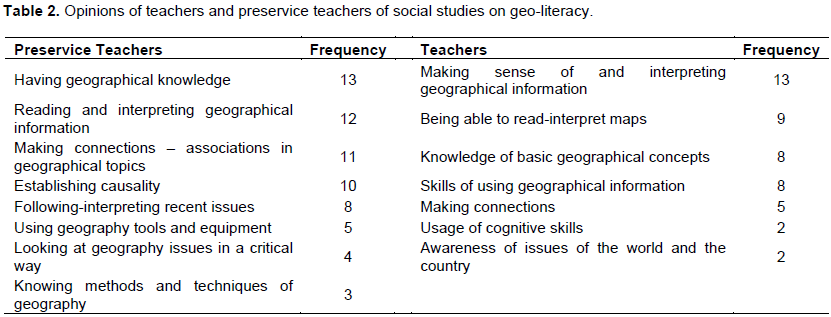
Geo-literacy covers qualities of being able to read, interpret and analyze information such as maps, tables and charts. It also means having up-to-date knowledge by following journals and magazines in the field of geography (PT. 21). Geo-literacy is mainly the knowledge of a person on their own environment, country and the world and association of geographical events with the life and current events (PT. 13). Geo-literacy can be used to understand the geographical events that take place in the province, region and world one lives in. It is knowing and being able to explain basic concepts related to geography. It is gaining the skills of understanting, interpreting, reading the economic and cultural events in the world. It is following, interpreting and being aware of the things happening in the media (PT. 8). Geo-literacy is interpretation and making sense of a set of terms, places, cases and genuine methods regarding geography by establishing causality relationships (PT. 29). Geo- literacy is the ability to read, interpret a map-table when seen, relate current affairs to geography and use geographical tools (PT. 5). It is knowing about – recognizing basic concepts related to geography, have a knowledge about maps and be aware of national and international issues (T. 1). It is the skill to use geographical knowledge to a sufficient extent. It is able to use all kinds of terms, definitions and concepts related to geography. It is to know how to utilize geography and establish connections among events (T. 6).
Accordingly, both the teachers and preservice teachers of social studies used having geographical knowledge, making sense of- interpreting geographical knowledge, making connections and association as their common definition of geo-literacy. In difference to the teachers, the preservice teachers also used definitions of following and interpreting current events and looking at issues in a critical way.
As shown in Table 3, as social studies are interdisciplinary, the prospective teachers reported geo-literacy is important because of skills of interdisciplinary association (10) and better understanding of geographical topics; the teachers stated that it is important in terms of recognizing national and international facts (11) and being able to analyze the effects of geography on human life (7). Some of the opinions of the preservice teachers and teachers of social studies are as follows:
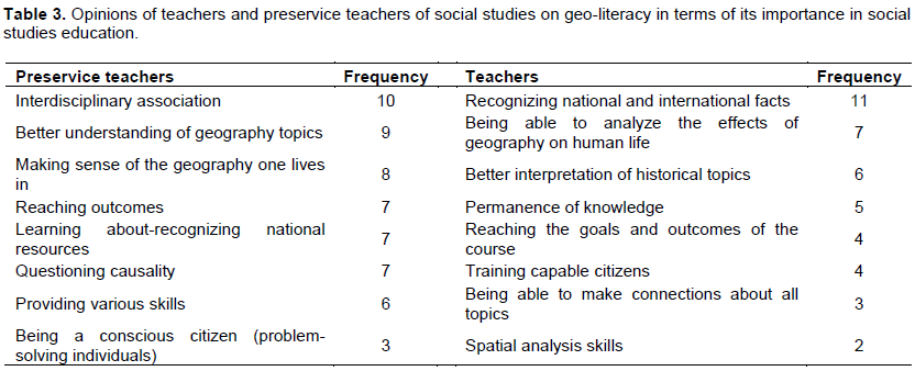
The social studies lesson is a highly interdisciplinary lesson. In this discipline, not all subject can be separated from each other, but they are connected. One utilizes geography while teaching topics of history. Geo-literacy is important in terms of associating subjects with each other. It is also included in the goals of social studies. Various topics and disciplines are related to each other and to geography. Various taught and learned disciplines have a relationship with and basis in geography. In this sense, it makes students to make sense of the geography of the area they live in by knowing about it and do research on it by getting more curious (PT. 8). Geography is a very important field for the lesson of social studies. Geography should be taught and instructed better for a higher quality understanding of geography as one of the most important sources of the social sciences course, and better permenance of the targeted skills, outcomes and values; only then, the outcomes and behaviors aimed to be provided may be provided, and an effective role may be taken on (PT. 14). Knowledge of students on the world they are living in, their understanding of what is happening in the world and recognition of resources are important issues in training problem-solving individuals and citizens. Moreover, skills like basic skills of map-reading, atlas-usage and navigation, are skills that need to be held by all people. Students firstly become aware of issues of their own environment, then their country and finally the world and produce solution to issues. These are the characteristics of a responsible citizen. The purpose of the social studies course is to train responsible citizens (PT. 23). I think geo-literacy is important for the knowledge to be permanent. With geo-literacy, the students not only reach the outcomes of social studies, but they are able to correctly interpret topics of history (T. 10). The social studies lesson is a multidisciplinary course. A student who gains geo-literacy may learn all subjects better and establish connections. They may understand national and international realities better. They may relate issues to geography and interpret them better. It is important in terms of training citizens whose cognitive skills such as critical thinking, problem-solving and decision-making skills are advance (T. 6).
Findings regarding the characteristics a geo-literate individual should have
According to Table 4, while the prospective teachers of social sciences mostly stated that a geo-literate individual should have skills such as spatial perception, critical thinking, problem-solving, observation, research … (41) and know about field-specific concepts, the teachers of social sciences mostly stated that such individuals should be people who are able to establish causality relationships (12) and have advanced map knowledge and cognitive skills. Some of the opinions of the prospective teachers and teachers of social sciences are as follows:
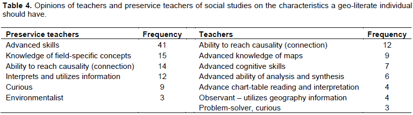
They should be critical-minded, curious, environmentalist, observant people who are able to solve problems based on scientific operation steps, with advanced map reading and interpretation skills, advanced navigation skills, interest in research, who produce rational solutions, and carry these qualities (PT. 4). They should have critical thinking and problem-solving skills and be able to solve problems they encounter. They should be curious people who like to observe (PT. 15). They should be able to understand and interpret the geographical events around them, and make inferences by connecting cause and effect (PT. 9). They should be people who know the basic concepts of geography with advanced map reading skills, critical way of thinking, observation skills and qualities of a researcher and observer (PT. 28). They should be people with advanced knowledge of maps, capable of perceiving the environment they are in via problem-solving skills, capable of reading and interpreting maps, tables and charts, establishing connections by thinking about the causes and effects of events, and use and transfer geographical information into other situations (T. 13). They should be people with advanced knowledge on maps and who are able to show locations on a map, make sense of their daily experiences better in the context of the geographies they take place, and use the ways of thinking in geography (T. 19).
Findings related to how geo-literacy is developed
As shown in Table 5, the teachers and preservice teachers of social studies stated that spatial perception activities (map usage–interpretation-empty map, globe usage, chart-table reading and interpretations) (17-11), trips-observations (13-10) and usage of images (10-10) should be frequently employed to provide people with geo-literacy. The teachers also stated that it is important in providing geo-literacy to frequently asked questions such as why, for what and how, which improve thinking, fun games, repetitions, usage of current issues and materialization. Some of the opinions of the prospective teachers and teachers of social sciences are as follows:
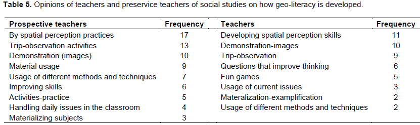
In order to develop geo-literacy, firstly, the skills of reading and interpreting maps, tables and charts should be developed in students. Empty maps, tables, charts and maps should be frequently used in classes. Different methods and techniques that will encourage students should be employed, for example, the station techniques, question and answer, debate, observation, collaborative learning, or interviews about migrations. Field trips of virtual trips may be organized. Various topics of geography and projects related to the environment may be given as assignments. Documentaries, images should be frequently included in the classroom (PT. 9). Classes should be based on materialization instead of memorization. We should develop this in students as much as technology allows using three-dimensional simulations, images and trips-observations. Additionally, different techniques and methods should be used frequently in the classroom (PT. 17). Geo-literacy develops by providing the student with various skills such as critical thinking, research and observation skills. Additionally, usage of maps, tables, charts, empty maps, materials and images also improves skills (PT. 22). The most suitable method to develop geo-literacy is trips-observations. This is because the student finds the opportunity to learn by experiencing and doing in this process. Additionally, the teacher should use different methods and techniques in the classroom. Maps, empty maps should definitely be used, and the learning environment should be enriched by images (T. 3). Usage of maps, emptry maps and atlases is important in developing geo-literacy. Activities of reading and interpreting maps and charts should be employed. Research assignment should be given. Asking questions such as why, for what and how, which will encourage the student to think, improves the power of analysis and synthesis (T. 12).
Findings regarding the skills and values that should be provided to develop geo-literacy
According to Table 6, preservice teachers of social studies stated that the most important skills are spatial perception (24), critical thinking (23), problem-solving (20) and observation (19) and the most important values are awareness (26), responsibility (25) and patriotism. Teachers stated that most important skills are spatial perception (15), observation (8), problem solving (4) and the most important values are awareness (15), responsibililty (8), patriotism (5). Some of the opinions of the preservice teachers and teachers of social studies are as follows:
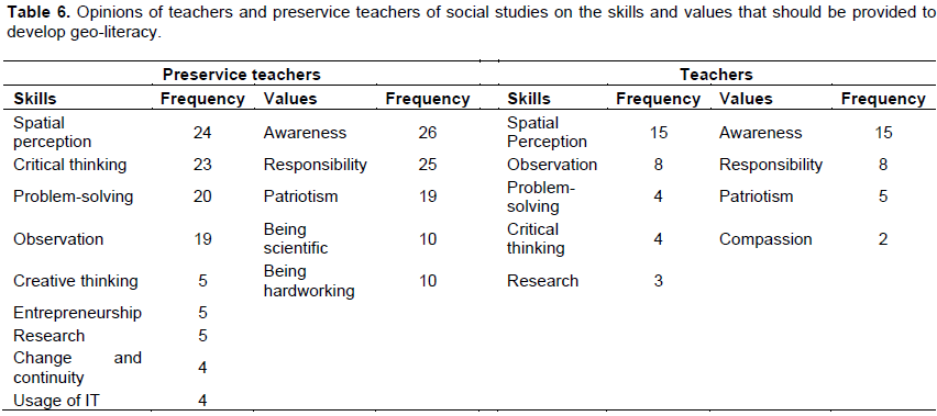
In social studies classes, in order to develop geo-literacy in students, the focus should be on critical thinking, problem-solving, spatial perception and observation skills. Regarding values, as citizens, environmental awareness, responsibility, working hard, being scientific and patriotism should be emphasized as much as possible (PT. 13). The most important skill in geo-literacy is spatial perception. Skills of reading and implementing maps, tables and charts should be developed in students. Skills of questioning causality relationships should be focused on. Observations should be made by the people. Environmental awareness and citizenship responsibilities may be developed as values (T. 8). Values of patriotism (recognition of own country, land and nation), responsibility for the country and awarenss of the environment and the country are important. Additionally, compassion for different geographies may also be developed (T. 14).
Issues about geo-literacy and recommendations for solutions
As shown in Table 7, preservice teachers of social studies stated that there is insufficient focus on spatiel perception, lack of inclusion of images, trips and observations, problems in materializing abstract information, incomplete explanation of concepts and lack of practice activities. Teachers of social studies stated that trips and observations cannot be included enough due to the procedures at schools, and although the number of outcomes is high in the curriculum, the class hours are insufficient, there is a lack of sufficient activities and usage of maps, and teachers are inadequately knowledgeable about geo-literacy. Some of the opinions of the preservice teachers and teachers of social studies are as follows:
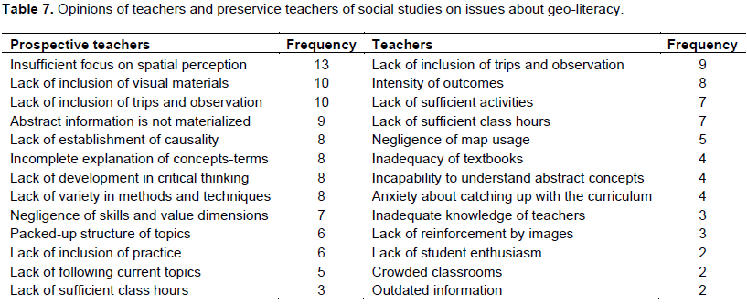
The topics are intensive and boring for students, teachers are not discussing the topics using different methods and techniques, some subjects are abstract and they are not materialized, some subjects and especially some concepts are not completely explained, the students are reluctant, and there is insufficient focus on the skills for reading and interpreting maps, tables and graphics (PT. 4). Visual materials are not used sufficiently while discussing geography topics, subjects are not materialized, different methods towards increasing permanence are not used, practices towards interpreting maps and tables are not included frequently, the curriculum is crowded with topics, the cause and effect relationships among events are not sufficiently emphasized, and there are no trips and observations (PT. 22). As the geography education is provided theoretically and it does not include practice, it cannot be internalized. As it is just memorized, as the system of memorization where the student is inactive, this literacy cannot be developed (PT. 11). There is lack of materials like maps in schools or their insufficient usage, failure to follow current issues and associate them with geography, lack of visual material usage, failure to provide fun methods and techniques (PT. 21). There are too many targeted outcomes in the curriculum. This is why we are struggling to catch up with the curriculum. There are not many activities towards geo-literacy. There is also lack of knowledge in this subject. I think textbooks are also insufficient in this matter (T. 7). Insufficient class hours, intensity of the curriculum, failure to take part in activities that will put geographical information into practice, difficulties of students to understand abstract subjects and their unwillingness seem to be the most important problems in my opinion (T. 19).
As shown in Table 8, as recommendations for solutions to issues in geo-literacy, the teachers and preservice teachers of social studies mostly stated increasing trips-observations (11-7), using practice in classes. The teachers of social studies stated that the class hours for the social studies course should be included and the targeted outcomes should be reduces, textbooks should be made effective, and teachers should be given in-service training regarding geo-literacy. Some of the opinions of the prospective teachers and teachers of social sciences are as follows:
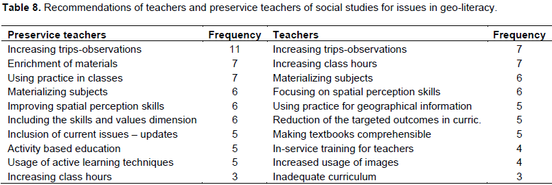
If we want to develop geo-literacy, we should first improve skills of reading and interpreting maps, tables and charts. Trips-observations should be made more frequent in our schools. We are only looking at the knowledge dimensions, but the values and skills dimensions should also be focused on. The subjects should be provided in compliance with teaching principles, and practices should be taken on to lead students to establish causality relationships and think creatively (PT. 9). Trips-observations should be increased in number. Materials, visuals and simulations should be enriched. Critical thinking skills should be improves and establishment of connections among subjects should be achieved. The practice part should be focused on more than the theoretical part. Current information should be provided, and at the same time, connections should be established with geographical topics by including current issues (PT. 12). The students mainly learn by seeing. For example, when I saw Karapınar in Konya [Turkey], I was moved by the erosion example. Therefore, trips and observations should be included. The procedure and responsibility of trips limit the teachers extensively. Images, maps, tables, chards, photographs, conceptual maps and similar visuals attract students during classes. Smartboards should be used effectively in this matter (T. 4). As students have difficulty in understanding abstract concepts, the subjects should be taught by materializing those concepts. Students should be asked to practice and taught how to use the information in daily life. Class hours should be increased, trips should be organized in relation to topics, the quality of books and textbooks should be increased and teachers should be improved with in-service training (T. 18).
Findings regarding the geo-literacy levels of preservice teachers of social studies
As shown in Table 9, while the prospective teachers of social studies stated that they were on an intermediate level in terms of knowing geographical information and concepts and causality; they stated that they did not find themselves sufficient in terms of spatial perception skills (reading and interpreting maps-tables-charts), making connections among events, association, as well as in the dimension of following geographical issues and looking at things critically.
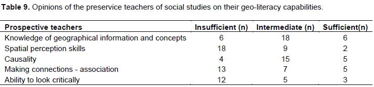
I cannot say that I see myself adequate in terms of geo-literacy. I do not think I am very capable of concepts, and reading and interpretation of maps, tables and charts. I am not completely capable of solving scale and time problems. I do not see myself competent in making connections and association things. I should improve myself in this matter (PT. 5). I know the concepts in geo-literacy. However, I cannot say I am sufficient in interpretation of maps, tables, charts, making connections and associations, and relating geographical topics by following current issues (PT. 22). I know very much about some geographical concepts and I can describe them. However, I cannot describe some concepts even though I know what they are called. I do not completely know the reasons for some geographical events, and I do not know the details and the reasons why some happened. I am not very capable in the area of association and table-chart interpretation (PT. 14).
While the prospective teachers of social studies defined geo-literacy as having geographical knowledge, reading and interpreting geographical information; the teachers of social sciences defined it as making sense of interpreting geographical information and reading-interpreting maps. Welton (1988) described geo-literacy by combining three main elements: knowledge of the physical environment, map usage skills and knowledge of the main concepts of geography. The teachers and preservice teachers of social studies provided similar definitions. According to the definition of geo-literacy by Oligara (2006), the teachers and the preservice teachers mostly mentioned the steps of having knowledge on the lower-level, establishing relationship with the environment, inquiry and analysis on the intermediate-level, while the rarely mentioned the critical geography approach, which is higher-level literacy.
While the preservice teachers stated that geo-literacy is important for achieving association among disciplines and better understanding of geographical subjects as the social studies course is interdisciplinary, the teachers said it is important in terms of recognizing national and international realities and analyzing the effects of geography on human life. There was an agreement between the goals stated in the social studies course curriculum and the opinions (MEB, 2005).
As the characteristics that a geo-literate individual should have, the preservice teachers most frequently mentioned: skills of spatial perception, critical thinking, problem-solving and observation, and knowledge of field-speficif concepts, while the teachers said they should be individuals who are able to establish cause and effect relationships of events and have advanced knowledge of maps and cognitive skills. According to the social studies curriculum, the skills directly related to geography topics are observation and spatial perception skills. Additionally, other skills that aimed to be developed via geography topics are skills of atlas usage, perception of time, reading maps and reading and preparation of charts (MEB, 2005). The teachers and preservice teachers of social studies also emphasized these skills.
The teachers and preservice teachers stated that, in order to develop geo-literacy, spatial perception practices, trips-observations and visual materials should be utilized frequently. The teachers also added that frequently asking questions that improve thinking such as why, for what and how, repetitions with fun games, usage of current issues and materialization of abstract subjects are important in developing geo-literacy.
Regarding what could be the values and skills to be provided while developing geo-literacy, the teachers and preservice teachers stated the the most important skills are spatial perception, observation, problem-solving and critical thinking, and the most important values are awareness (for the environment, country and world), responsibility and patriotism. The geographical skills necessary to teach geography and help development of geographical thinking in students may be listed as skills of asking geographical questions, gaining geographical knowledge, organizing and analyzing this knowledge, and answering geographical questions (Demirkaya, 2003).
While the preservice teachers stated that they knew about geographical information-concepts and reasons for events on an intermediate level, they said they did not see themselves as adequate in skills of spatial perception (reading and interpretion maps-tables-charts), making connections among events, association, and being able to consider a geographical issues in a critical way by following them. Some other studies had similar results (Cross, 1987; Kinney et al., 1988; Saarinen and Maccabe, 1995; Wood et al., 1988; Chiodo, 1993; Eve et al., 1994; Hardwick et al., 2000; Thomas, 2001; Tuncel, 2002; Gençtürk, 2009; Demirkaya 2009). Relevant studies showed that the geo-literacy levels of university students are low.
Regarding the issues seen in geo-literacy; the preservice teachers stated that classes do not focus on skills of spatial perception frequently, visuals, trips and observations are not included, there are problems in materialization of abstract information, concepts are not completely explained, and there is no practice component. The teachers stated that trips-observations are not included in schools due to excessive procedures, class hours are short despite the high number of the targeted outcomes in the curriculum, there is a lack of sufficient activities and map usage, and teachers do not have enough knowledge about geo-literacy. Akengin et al. (2016) found that teachers of social studies did not have sufficient knowledge on map, and they failed to take part in sufficient practices to develop map literacy in students due to the lack of sufficient class hours and intensity of targeted outcomes. Erol (2016) examined social studies textbooks, and it was shown that content related to geo-literacy was seen most frequently in ther 6th grade social studies textbook followed by the 5th grade textbook, while it was least frequently seen in the 7th grade textbook. As a result of the study, they concluded that the content in all three grade levels was not desirable in terms of quality and quantity. It was found that the ratio of outcomes related to geo-literacy among all outcomes in the social studies course curriculum was 7%. As stated by Akpinar and Ayvaci (2003), there are inadequacies in formation of curricula regarding the characteristics of the time, changed conditions, individual and social needs, and scientific and technological developments. The opinions of the teachers and preservice teachers in the field support these findings about the curriculum.
As a recommendation for solutions to issues experienced in geo-literacy, the teachers and preservice teachers of social studies mostly stated that, trips-observations should be increased in frequency, and classes should be held in an applied/practical way. In the study by Demirkaya (2015), it was proposed to increase the amount of trips-observations for the sake of geo-literacy. Studies have shown that trips influence geo-literacy positively (Bein, 1990; Nolan, 2002; Winship, 2004; Oigara, 2006). The teachers of social studies stated that the class hours for the social studies course should be included and the targeted outcomes should be reduces, textbooks should be made effective and teachers should be given in-service training regarding geo-literacy.
The following recommendations are presented based on the opinions of teachers and preservice teachers of social studies. In order to increase geo-literacy, in middle schools and universities, trips-observations should be more frequent, classes should be held with practice/application components, spatial perception skills should be frequently focused on and the class hours of geography should be increased. In middle schools, the targeted outcomes of the social studies course should be cut down, textbooks should be made adequate, skills of spatial perception should be focused on more and teachers should be provided with in-service training for geo-literacy. Additionally, current issues should also be included in social studies and geography courses, associations should be made with topics of geography and adjustments should be made in textbooks.
The authors have not declared any conflict of interests.
REFERENCES
|
Akengin H, Tuncel G, Cendek ME (2016). ÖÄŸrencilerde harita okuryazarlığının geliÅŸtirilmesine iliÅŸkin sosyal bilgiler öÄŸretmenlerinin görüÅŸleri. Marmara Geographical Review. Temmuz/July, 34:61-69.
|
|
|
|
Akpınar M, Ayvacı HÅž (2003). Sosyal bilgiler öÄŸretmen adaylarının sosyal bilimlerin temel disiplinlerine karşı tutumları. Milli EÄŸitim Dergisi. 158:137-145.
|
|
|
|
|
Aydın F, Güngördü E (2015). CoÄŸrafya eÄŸitiminde özel öÄŸretim yöntemleri. Ankara: Pegem Akademi.
|
|
|
|
|
BaÅŸkale H (2016). Nitel araÅŸtırmalarda geçerlik, güvenirlik ve örneklem büyüklüÄŸünün belirlenmesi. Dokuz Eylül Üniversitesi HemÅŸirelik Fakültesi Elektronik Dergisi. 9(1):23-28.
|
|
|
|
|
Bein FL (1990). Baseline geography competency test: Administered in Indiana Universities. J. Geogr. 89(6):260-266.
Crossref
|
|
|
|
|
Catling S (2015). Ä°lköÄŸretimde coÄŸrafya önemlidir!. Åženyurt, S. (Trans.). CoÄŸrafya EÄŸitimi Dergisi. 1(1):29-36.
|
|
|
|
|
Chiodo JJ (1993). Mental maps: preservice teachers' awareness of the world. J. Geogr. 92(3):110-117.
Crossref
|
|
|
|
|
Cross JA (1987). Factors associated with students' place location knowledge. J. Geogr. pp. 59-63.
Crossref
|
|
|
|
|
Demirkaya H (2003). CoÄŸrafya öÄŸretiminde örnek bir çalışma. Milli EÄŸitim Dergisi. P 157.
|
|
|
|
|
Demirkaya H (2009). Üniversite öÄŸrencilerinin coÄŸrafya okuryazarlığı burdur örneÄŸi. Ankara: Pegem Akademi Yayıncılık.
|
|
|
|
|
Demirkaya H (2015). CoÄŸrafya öÄŸretmen adaylarının Türkiye'nin yakın gelecekteki uluslararası iliÅŸkilerine bakışı: Bir coÄŸrafya okuryazarlığı analizi. Int. J. Soc. Educ. Sci. 2(3):57-86.
|
|
|
|
|
Dikmenli Y (2013). Geographic literacy perception scale (GLPS) validity and reliability study. Mevlana Int. J. Educ. (MIJE). 4(1):1-15.
Crossref
|
|
|
|
|
DoÄŸanay H (2011). Anlamı, tanımı, konusu ve felsefesi bakımından coÄŸrafya ilmi hakkında bazı düÅŸünceler. DoÄŸu CoÄŸrafya Dergisi. (25):1-44.
|
|
|
|
|
Donovan I (1993). Geographic literacy and ignorance: A survey of Dublin adults and school children. Geogr. Viewpoint, (21):73-92.
|
|
|
|
|
Edelson DC (2012). Geo-education: Pre-paration for 21st-century decisions. February (11).
|
|
|
|
|
Erol H (2014). Ortaokul öÄŸrencilerinin coÄŸrafya okuryazarlık düzeylerinin belirlenmesi. (Unpublished PhD Thesis). Afyonkarahisar Üniversitesi, Afyonkarahisar.
|
|
|
|
|
Erol H (2015). YetiÅŸkinlerin coÄŸrafya okuryazarlık düzeylerinin belirlenmesi-Adıyaman örneÄŸi. Int. J. Soc. Sci. JASS. Autumn II (38):383-406.
|
|
|
|
|
Erol H (2016). Ortaokul 5., 6. Ve 7. Sinif sosyal bilgiler ders kitaplarinin coÄŸrafi okuryazarlik açisindan deÄŸerlendirilmesi. Adıyaman Üniversitesi Sosyal Bilimler Enstitüsü Dergisi.1(1):129-163.
Crossref
|
|
|
|
|
Eve RA, Price B, Counts M (1994). Geographic iliteracy among college students. Youth Soc. 25(3):408-427.
Crossref
|
|
|
|
|
Gençtürk E (2009). Ä°lköÄŸretim sosyal bilgiler öÄŸretmen adaylarının coÄŸrafya okuryazarlık düzeylerinin belirlenmesi. (Unpublished PhD thesis). Gazi University, Ankara.
|
|
|
|
|
Hardwick SW, Bean LL, Alexander KA, Shelley FM (2000). Gender vs. sex differences: Factors affecting performance in geographic education. J. Geogr. 99(6):238-244.
Crossref
|
|
|
|
|
Kabapınar F (2003). Kavram yanılgılarının ölçülmesinde kullanılabilecek bir ölçeÄŸin bilgi kavrama düzeyini ölçmeyi amaçlayan ölçekten farklılıkları. EÄŸitim Yönetimi Dergisi. 9(3):398-417.
|
|
|
|
|
Kitchin RM (1996). Are there sex differences in geographic knowledge and understanding?. Geogr. J. 162(3):273-286.
Crossref
|
|
|
|
|
MEB (2005). Ä°lköÄŸretim sosyal bilgiler dersi 6-7. sınıflar öÄŸretim programı ve kılavuzu. MEB yayınevi. Ankara.
|
|
|
|
|
Meydan A (2011). Sosyal bilgilerde coÄŸrafyanın yeri ve önemi. Turan R, Ulusoy K (Ed.). Sosyal bilgilerin temelleri. Ankara: Pegem Akademi.
|
|
|
|
|
Miles MB, Huberman AM (1994). Qualitative data analysis: An expanded sourcebook. Thousand Oaks London: Sage Publication.
|
|
|
|
|
National Council for The Social Studies (NCSS) (2002). National standarts for social studies teacher. Volume I. United States of America.
|
|
|
|
|
National Geographic Roper (2002). Global geographic literacy survey. Prepa-red by Roper ASW for: National Geographic Education Foundation. Washington D.C.
|
|
|
|
|
National Geographic Roper Public Affairs (2006). Geographic literacy prepared by Roper ASW for: National Geographic Education Foundation. Washington D.C.
|
|
|
|
|
Nolan RE (2002). Geo-literacy:How well adults understand the world in which they live. Adult Basic Educ. 12(3):134-144.
|
|
|
|
|
Oigara J (2006). A Multi-method study of background experiences influencing levels of geographic. Ph.D. Thesis Binghamton University, USA.
|
|
|
|
|
Özey R (2002). Dünya ve Türkiye ölçeÄŸinde siyasi coÄŸrafya. Ä°stanbul: Aktif Yayınları
|
|
|
|
|
Öztürk C (2007). Sosyal bilgiler: Toplumsal yaÅŸama disiplinler arası bir bakış. Öztürk C. (Ed.). Hayat bilgisi ve sosyal bilgiler öÄŸretimi yapılandırmacı bir yaklaşım. Ankara: Pegem A Yayıncılık.
|
|
|
|
|
Öztürk Ç (2008). CoÄŸrafya öÄŸretiminde 5E modelinin bilimsel süreç becerilerine, akademik baÅŸarıya ve tutuma etkisi. (Unpublished phD thesis). Gazi Üniversitesi, Ankara.
|
|
|
|
|
Patton MQ (2014). Qualitative research and evaluation methods. (Trans:M. Bütün, S. B. Demir).Ankara: Pegem Akademi.
|
|
|
|
|
Saarinen TF, MacCabe CL (1995). World patterns of geographic literacy based on sketch map quality. Professional Geographers, 47(2):196-204.
Crossref
|
|
|
|
|
Sievertson M (2005). Is geography knowledge improving? A study of current geographic knowledge among united states college geograpy students. (Unpublished PhD thesis). Delta State University, Cleveland Mississipi.
|
|
|
|
|
Åžahin S (2003). CoÄŸrafya öÄŸretiminde beÅŸ temel konu. EÄŸitim Bilimleri Kongresi XII. (15-18 Ekim 2003). Antalya.
|
|
|
|
|
Åžahin S (2010). CoÄŸrafyada çaÄŸdaÅŸ öÄŸretim yöntemleri. R Özey, S Ä°ncekaya (Ed). CoÄŸrafya eÄŸitiminde kavram ve deÄŸiÅŸmeler. Ankara: Pegem Yayınevi.
|
|
|
|
|
Thomas PG (2001). An analysis of the geographic knowledge of preservice teachers at selected Midwestern universities. (Unpublished phD thesis). Kansas State University. Kansas.
|
|
|
|
|
Tuna F (2013). Türkiye'de üniversite öÄŸrencilerinin coÄŸrafi okuryazarlık düzeyleri: Mevcut durum analizi ve öneriler. Türkiye CoÄŸrafyacılar DerneÄŸi Yıllık Kongresi, Ä°stanbul.
|
|
|
|
|
Ünlü M (2014). CoÄŸrafya öÄŸretimi. Ankara: Pegem Akademi.
|
|
|
|
|
Winship JM (2004). Geographic literacy and world knowledge among undergraduate college students. (Master of Science in Geography). Virginia Polytechnic Institute and State University, Virginia.
|
|
|
|
|
Wood WR., Eicher C, Webster L, Gullickson A (1988). Geographical knowledge of university elemantary education reports. Majors. The University of South Dakota.
|
|
|
|
|
Yıldırım A, ÅžimÅŸek H (2013). Sosyal bilimlerde nitel araÅŸtırma yöntemleri. Ankara: Seçkin Yayınevi.
|
|
|
|
|
Yıldırım T (2016). Sosyal bilgiler ve sınıf öÄŸretmenliÄŸi öÄŸrencilerinin coÄŸrafya okuryazarlığı algı düzeylerinin incelenmesi. Turkish Studies. International Periodical for the Languages, Literature and History of Turkish or TurkicVolume. 11(14):847.
|
|